Embed Size (px)
Citation preview
Universidade Federal de São Carlos CENTRO DE CIÊNCIAS AGRÁRIAS- campus de Araras
Prof. Dr. Rubismar Stolf - [email protected]
Departamento de Recursos Naturais e Proteção Ambiental
Via Anhanguera, km 174. Cx.Postal.153 CEP 13600-970 ARARAS SP BR
Acervo técnico do Prof. Dr. Rubismar Stolf
Acesso: http://www.servidores.ufscar.br/hprubismar/hprubismar.htm ou:
http://www.cca.ufscar.br/drnpa/hprubismar.htm
125. BENTOS, ADRIEL BARBOZA ; GALLO, ANDERSON DE SOUZA ; GUIMARÃES, NATHALIA DE FRANÇA ; SOUZA, MAICON DOUGLAS BISPO DE ; STOLF, RUBISMAR ; BORGES, MARIA TERESA MENDES RIBEIRO . Rapid Assessment of Habitat Diversity Along the Araras Stream, Brazil. FLORAM, v. 25, p. 1-10, 2017. http://dx.doi.org/10.1590/2179-8087.002416
Para visualizar o trabalho vá para a próxima página ↓
Floresta e Ambiente 2018; 25(1): e20160024http://dx.doi.org/10.1590/2179-8087.002416
ISSN 2179-8087 (online)
Original Article
Conservation of Nature
Rapid Assessment of Habitat Diversity Along the Araras Stream, Brazil
Adriel Barboza Bentos1, Anderson de Souza Gallo1, Nathalia de França Guimarães1, Maicon Douglas Bispo de Souza1,
Rubismar Stolf2, Maria Teresa Mendes Ribeiro Borges3
1Programa de Pós-graduação em Agroecologia e Desenvolvimento Rural, Universidade Federal de São Carlos – UFSCar, Araras/SP, Brazil
2Departamento de Recursos Naturais e Proteção Ambiental, Universidade Federal de São Carlos – UFSCar, Araras/SP, Brazil
3Departamento de Tecnologia Agroindustrial e Sócio-Economia Rural, Universidade Federal de São Carlos – UFSCar, Araras/SP, Brazil
ABSTRACTAgriculture, urbanization, and industrialization are some of the anthropogenic activities that constantly generate negative impacts on natural environments. Part of this degradation directly affects aquatic systems. This study aimed to evaluate the visual characteristics of the Araras Stream, located in the municipality of Araras, São Paulo state, Brazil. Data was collected at six different assessment sites along the river in both rural and urban areas. The evaluation used a Rapid Habitat Diversity Assessment (RHDA) protocol composed of 22 parameters, which define levels of preservation of ecological conditions. According to this protocol, the 32 Km-long study transect along the Araras Stream was rated as impacted (39.6 points). A separate assessment by transects showed that only Transect 1 presented a natural level of preservation (71.8 points). Transects located in the urban area contributed the most to impacts on the aquatic environment. The RHDA protocol proved to be an important tool to evaluate and monitor aquatic environments.
Keywords: aquatic ecosystems, riparian vegetation, anthropogenic activities.
1. INTRODUCTION
Aquatic ecosystems and the history of water on planet Earth are multifaceted. The close relationship between pollution levels and population density is determined by three main factors: urbanization, industrialization, and large-scale agriculture. Population growth with its consequent urbanization and increase in agricultural areas, reduces the water retention capacity of river basins and the natural capacity to retain pollutants.
In view of the complexity of water use by humans, aquatic ecosystems are the most affected by environmental pollution. Loss of water quality and availability has been observed in several regions and countries due to degradation (Tundisi, 2003).
In the context of aquatic systems, a watershed is a geographic region bounded by water dividers, encompassing the whole catchment area of a waterway. It is a natural geographic unit and its boundaries are established by the flow of water on the surface over time. It is, therefore, the result of the interaction of water with other natural resources (Rocha, 1991).
The micro basin of the Araras Stream is located in the central part of the municipality of Araras, Sao Paulo state, Brazil, and is a good example of anthropogenic actions. The water quality of this stream is affected by different processes of land use and occupation. In addition to mining, deforestation, and pesticide
2/10 Bentos AB, Gallo AS, Guimarães NF, Souza MDB, Stolf R, Borges MTMR Floresta e Ambiente 2018; 25(1): e20160024
use in agricultural areas, intense urban and industrial occupation is observed throughout the basin, which pollutes the stream (Projeto Ecoagri, 2006).
Godoi (2008) highlighted the great importance of characterizing and controlling water quality. In urbanized regions, this control is an essential condition for the evolution and development of populations, either from a socioeconomic perspective or to obtain and maintain quality of life. In rural areas, the importance of monitoring water quality mainly concerns the conservation of ecosystems and the quality of agricultural activities. As a result, methods for rapid qualitative assessment have been developed to describe the holistic quality of the physical habitat of aquatic ecosystems (Hannaford et al., 1997). These methods integrate a set of variables representative of the main components that determine the ecological processes of river systems (Callisto et al., 2002; Rodrigues & Castro, 2008).
In this sense, the Rapid Habitat Diversity Assessment (RHDA) protocols are introduced, given that they are methodological tools used to evaluate the levels of conservation of environmental conditions in river transects. Therefore, these protocols take into acount the integrated analysis of lotic ecosystems based on the reading of easily understood and quickly applied parameters. Therefore, RHDA protocols are an important tool in environmental monitoring programs (Callisto et al., 2001, 2002; Rodrigues et al., 2008).
The purpose of the present study was to evaluate the environmental degradation processes in rural and urban areas in the longitudinal gradient of the Araras Stream watershed by means of qualitative and quantitative visual analyses using the RHDA protocol. Aiming to contribute to measures that mitigate ecological degradation, this study is expected to identify which stream transects had the greatest negative impact on the aquatic environment.
2. MATERIAL AND METHODS
2.1. Characterization of the study area
The municipality of Araras is located in the southeast region of Sao Paulo state, Brazil. It occupies an area of 644.8 Km2 within the 22º21’25”S; 47º23’03”W geographic coordinates, distant 152 Km from the state
capital city. It has a population of 118,000 inhabitants distributed as follows: 6% in the rural area and 94% in the urban area (IBGE, 2010).
The regional relief is represented by low rolling hills of sub-plain tops, whose slopes reach 5% on the sides and 3% at the top. Towards the north, the topography is more undulating, with slopes of up to 20%. On the flood plains flat areas or depressions with slope <2% are generally found. Dystrophic Red Latosol (Oxisol) is predominant in the region; these are strongly acid, ancient soils at an advanced stage of weathering, with low base saturation (Resende et al., 2007; Santos, 2006).
Climate in the region is Cwa according to Köppen classification, mesothermal, with hot summers, and dry winters with mean lowest and highest temperatures of 18 °C and 22 °C, respectively. The dry season is from April to September, with total rainfall in the driest month <30 mm. Most rainfall occurs in January or February (Magini & Chagas, 2003).
The Araras Stream micro basin is composed of other streams that flow west to east-northeast, and has its boundaries within the municipality (IBGE 1:50.000, Folha Araras-SF23YAII). The micro basin covers an area of approximately 400 Km2, being the main source of the Tambury Dam, which provides 15% of the water supply of the municipality and, according to Magini & Chagas (2003), presents a dendritic pattern similar to tree branches.
2.2. Field procedures and data analysis
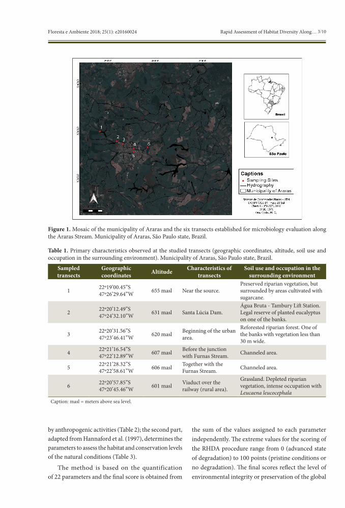
The choice of the studied transects was based on the criteria of ease of access and spatial distribution. Thus these transects were established upstream from the longitudinal gradient of Araras Stream comprising rural (Transects 1, 2, and 6) and urban (Transects 3, 4, and 5) areas, according to the mosaic shown in Figure 1.
The extension analyzed included a longitudinal gradient of approximately 32 Km and, as presented in Table 1, some basic characteristics observed are listed for each sampled transect.
The visual analysis was conducted according to the RHDA protocol. This protocol developed by Callisto et al. (2002) is composed of two parts: the first part, adapted from the Ohio Environmental Protection Agency, USA (EPA, 1987), seeks to evaluate the characteristics of the transect and the environmental impacts caused
3/10Rapid Assessment of Habitat Diversity Along…Floresta e Ambiente 2018; 25(1): e20160024
by anthropogenic activities (Table 2); the second part, adapted from Hannaford et al. (1997), determines the parameters to assess the habitat and conservation levels of the natural conditions (Table 3).
The method is based on the quantification of 22 parameters and the final score is obtained from
the sum of the values assigned to each parameter independently. The extreme values for the scoring of the RHDA procedure range from 0 (advanced state of degradation) to 100 points (pristine conditions or no degradation). The final scores reflect the level of environmental integrity or preservation of the global
Figure 1. Mosaic of the municipality of Araras and the six transects established for microbiology evaluation along the Araras Stream. Municipality of Araras, São Paulo state, Brazil.
Table 1. Primary characteristics observed at the studied transects (geographic coordinates, altitude, soil use and occupation in the surrounding environment). Municipality of Araras, São Paulo state, Brazil.
Sampled transects
Geographic coordinates Altitude Characteristics of
transectsSoil use and occupation in the
surrounding environment
1 22º19’00.45”S47º26’29.64”W 655 masl Near the source.
Preserved riparian vegetation, but surrounded by areas cultivated with sugarcane.
2 22º20’12.49”S47º24’32.10”W 631 masl Santa Lúcia Dam.
Água Bruta - Tambury Lift Station. Legal reserve of planted eucalyptus on one of the banks.
3 22º20’31.56”S47º23’46.41”W 620 masl Beginning of the urban
area.
Reforested riparian forest. One of the banks with vegetation less than 30 m wide.
4 22º21’16.54”S47º22’12.89”W 607 masl Before the junction
with Furnas Stream. Channeled area.
5 22º21’28.32”S47º22’58.61”W 606 masl Together with the
Furnas Stream. Channeled area.
6 22º20’57.85”S47º20’45.46”W 601 masl Viaduct over the
railway (rural area).
Grassland. Depleted riparian vegetation, intense occupation with Leucaena leucocephala
Caption: masl = meters above sea level.
4/10 Bentos AB, Gallo AS, Guimarães NF, Souza MDB, Stolf R, Borges MTMR Floresta e Ambiente 2018; 25(1): e20160024
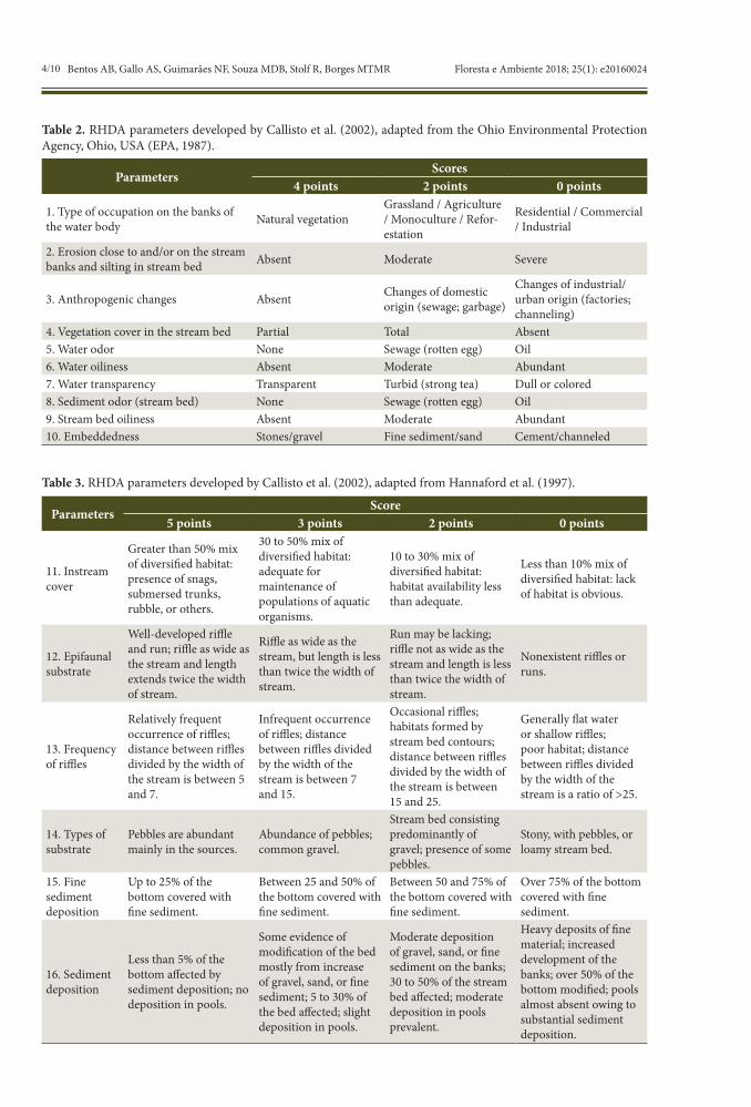
Table 2. RHDA parameters developed by Callisto et al. (2002), adapted from the Ohio Environmental Protection Agency, Ohio, USA (EPA, 1987).
ParametersScores
4 points 2 points 0 points
1. Type of occupation on the banks of the water body Natural vegetation
Grassland / Agriculture / Monoculture / Refor-estation
Residential / Commercial / Industrial
2. Erosion close to and/or on the stream banks and silting in stream bed Absent Moderate Severe
3. Anthropogenic changes Absent Changes of domestic origin (sewage; garbage)
Changes of industrial/urban origin (factories; channeling)
4. Vegetation cover in the stream bed Partial Total Absent5. Water odor None Sewage (rotten egg) Oil6. Water oiliness Absent Moderate Abundant7. Water transparency Transparent Turbid (strong tea) Dull or colored8. Sediment odor (stream bed) None Sewage (rotten egg) Oil9. Stream bed oiliness Absent Moderate Abundant10. Embeddedness Stones/gravel Fine sediment/sand Cement/channeled
Table 3. RHDA parameters developed by Callisto et al. (2002), adapted from Hannaford et al. (1997).
ParametersScore
5 points 3 points 2 points 0 points
11. Instream cover
Greater than 50% mix of diversified habitat: presence of snags, submersed trunks, rubble, or others.
30 to 50% mix of diversified habitat: adequate for maintenance of populations of aquatic organisms.
10 to 30% mix of diversified habitat: habitat availability less than adequate.
Less than 10% mix of diversified habitat: lack of habitat is obvious.
12. Epifaunal substrate
Well-developed riffle and run; riffle as wide as the stream and length extends twice the width of stream.
Riffle as wide as the stream, but length is less than twice the width of stream.
Run may be lacking; riffle not as wide as the stream and length is less than twice the width of stream.
Nonexistent riffles or runs.
13. Frequency of riffles
Relatively frequent occurrence of riffles; distance between riffles divided by the width of the stream is between 5 and 7.
Infrequent occurrence of riffles; distance between riffles divided by the width of the stream is between 7 and 15.
Occasional riffles; habitats formed by stream bed contours; distance between riffles divided by the width of the stream is between 15 and 25.
Generally flat water or shallow riffles; poor habitat; distance between riffles divided by the width of the stream is a ratio of >25.
14. Types of substrate
Pebbles are abundant mainly in the sources.
Abundance of pebbles; common gravel.
Stream bed consisting predominantly of gravel; presence of some pebbles.
Stony, with pebbles, or loamy stream bed.
15. Fine sediment deposition
Up to 25% of the bottom covered with fine sediment.
Between 25 and 50% of the bottom covered with fine sediment.
Between 50 and 75% of the bottom covered with fine sediment.
Over 75% of the bottom covered with fine sediment.
16. Sediment deposition
Less than 5% of the bottom affected by sediment deposition; no deposition in pools.
Some evidence of modification of the bed mostly from increase of gravel, sand, or fine sediment; 5 to 30% of the bed affected; slight deposition in pools.
Moderate deposition of gravel, sand, or fine sediment on the banks; 30 to 50% of the stream bed affected; moderate deposition in pools prevalent.
Heavy deposits of fine material; increased development of the banks; over 50% of the bottom modified; pools almost absent owing to substantial sediment deposition.
5/10Rapid Assessment of Habitat Diversity Along…Floresta e Ambiente 2018; 25(1): e20160024
situation found in the transects of basins under investigation (Rodrigues & Castro, 2008).
Assessment of the Araras Stream was conducted in December 2014. In each transect of the stream, the RHDA protocol was applied by four previously trained observers. Data was statistically analyzed using the Tukey test at 5% significance level (p<0.05) for intra-observer variation. For the scores from the RHDA protocol, arithmetical means were calculated and the parameters that presented scores ≤2 in Table 1
and ≤2.5 in Table 2 were classified as critical points (Carvalho et al., 2014).
The results were compared to a reference condition which presented the best habitat aspects listed in the protocol. After being graphically expressed, the results were classified according to the methodology by Callisto et al. (2002), which defines three levels of preservation: the range of 0 to 40 points indicates impacted transects; from 40 to 60 points indicates altered transects, and above 60 points indicates natural transects.
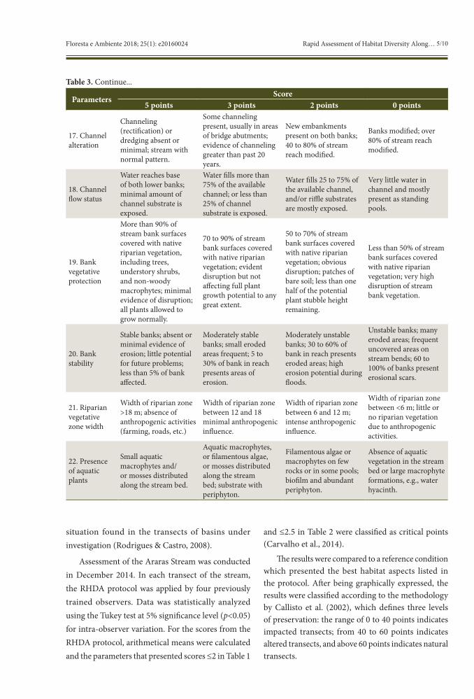
ParametersScore
5 points 3 points 2 points 0 points
17. Channel alteration
Channeling (rectification) or dredging absent or minimal; stream with normal pattern.
Some channeling present, usually in areas of bridge abutments; evidence of channeling greater than past 20 years.
New embankments present on both banks; 40 to 80% of stream reach modified.
Banks modified; over 80% of stream reach modified.
18. Channel flow status
Water reaches base of both lower banks; minimal amount of channel substrate is exposed.
Water fills more than 75% of the available channel; or less than 25% of channel substrate is exposed.
Water fills 25 to 75% of the available channel, and/or riffle substrates are mostly exposed.
Very little water in channel and mostly present as standing pools.
19. Bank vegetative protection
More than 90% of stream bank surfaces covered with native riparian vegetation, including trees, understory shrubs, and non-woody macrophytes; minimal evidence of disruption; all plants allowed to grow normally.
70 to 90% of stream bank surfaces covered with native riparian vegetation; evident disruption but not affecting full plant growth potential to any great extent.
50 to 70% of stream bank surfaces covered with native riparian vegetation; obvious disruption; patches of bare soil; less than one half of the potential plant stubble height remaining.
Less than 50% of stream bank surfaces covered with native riparian vegetation; very high disruption of stream bank vegetation.
20. Bank stability
Stable banks; absent or minimal evidence of erosion; little potential for future problems; less than 5% of bank affected.
Moderately stable banks; small eroded areas frequent; 5 to 30% of bank in reach presents areas of erosion.
Moderately unstable banks; 30 to 60% of bank in reach presents eroded areas; high erosion potential during floods.
Unstable banks; many eroded areas; frequent uncovered areas on stream bends; 60 to 100% of banks present erosional scars.
21. Riparian vegetative zone width
Width of riparian zone >18 m; absence of anthropogenic activities (farming, roads, etc.)
Width of riparian zone between 12 and 18 minimal anthropogenic influence.
Width of riparian zone between 6 and 12 m; intense anthropogenic influence.
Width of riparian zone between <6 m; little or no riparian vegetation due to anthropogenic activities.
22. Presence of aquatic plants
Small aquatic macrophytes and/or mosses distributed along the stream bed.
Aquatic macrophytes, or filamentous algae, or mosses distributed along the stream bed; substrate with periphyton.
Filamentous algae or macrophytes on few rocks or in some pools; biofilm and abundant periphyton.
Absence of aquatic vegetation in the stream bed or large macrophyte formations, e.g., water hyacinth.
Table 3. Continue...
6/10 Bentos AB, Gallo AS, Guimarães NF, Souza MDB, Stolf R, Borges MTMR Floresta e Ambiente 2018; 25(1): e20160024
3. RESULTS AND DISCUSSION
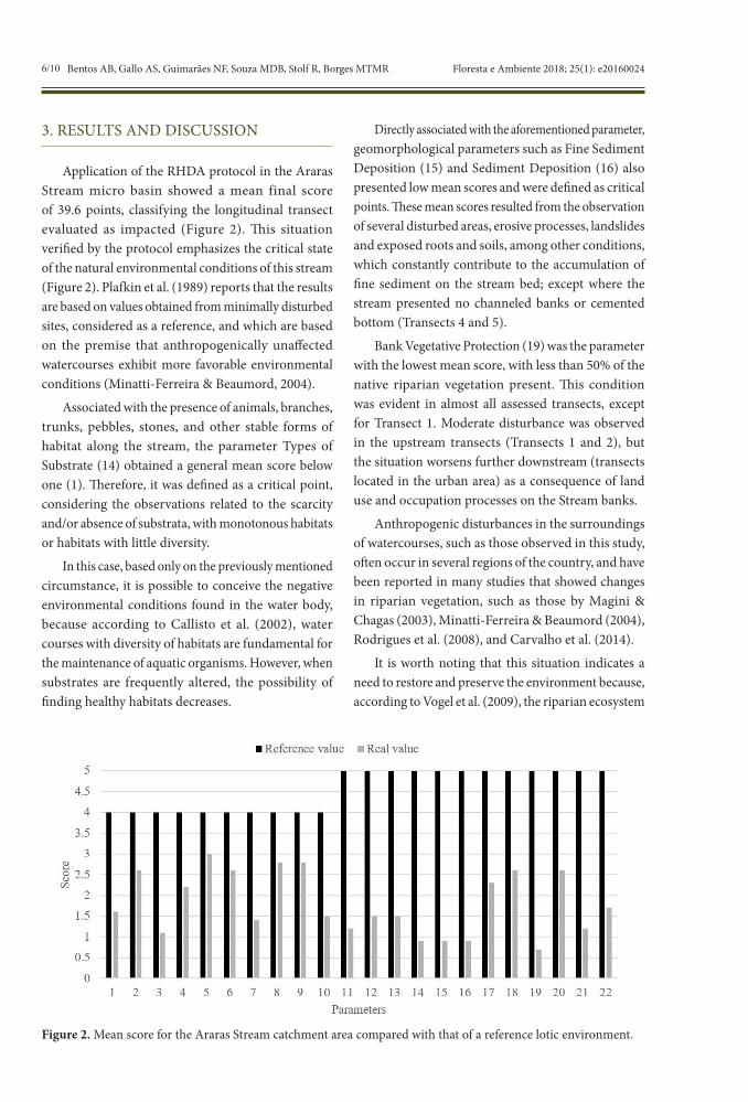
Application of the RHDA protocol in the Araras Stream micro basin showed a mean final score of 39.6 points, classifying the longitudinal transect evaluated as impacted (Figure 2). This situation verified by the protocol emphasizes the critical state of the natural environmental conditions of this stream (Figure 2). Plafkin et al. (1989) reports that the results are based on values obtained from minimally disturbed sites, considered as a reference, and which are based on the premise that anthropogenically unaffected watercourses exhibit more favorable environmental conditions (Minatti-Ferreira & Beaumord, 2004).
Associated with the presence of animals, branches, trunks, pebbles, stones, and other stable forms of habitat along the stream, the parameter Types of Substrate (14) obtained a general mean score below one (1). Therefore, it was defined as a critical point, considering the observations related to the scarcity and/or absence of substrata, with monotonous habitats or habitats with little diversity.
In this case, based only on the previously mentioned circumstance, it is possible to conceive the negative environmental conditions found in the water body, because according to Callisto et al. (2002), water courses with diversity of habitats are fundamental for the maintenance of aquatic organisms. However, when substrates are frequently altered, the possibility of finding healthy habitats decreases.
Directly associated with the aforementioned parameter, geomorphological parameters such as Fine Sediment Deposition (15) and Sediment Deposition (16) also presented low mean scores and were defined as critical points. These mean scores resulted from the observation of several disturbed areas, erosive processes, landslides and exposed roots and soils, among other conditions, which constantly contribute to the accumulation of fine sediment on the stream bed; except where the stream presented no channeled banks or cemented bottom (Transects 4 and 5).
Bank Vegetative Protection (19) was the parameter with the lowest mean score, with less than 50% of the native riparian vegetation present. This condition was evident in almost all assessed transects, except for Transect 1. Moderate disturbance was observed in the upstream transects (Transects 1 and 2), but the situation worsens further downstream (transects located in the urban area) as a consequence of land use and occupation processes on the Stream banks.
Anthropogenic disturbances in the surroundings of watercourses, such as those observed in this study, often occur in several regions of the country, and have been reported in many studies that showed changes in riparian vegetation, such as those by Magini & Chagas (2003), Minatti-Ferreira & Beaumord (2004), Rodrigues et al. (2008), and Carvalho et al. (2014).
It is worth noting that this situation indicates a need to restore and preserve the environment because, according to Vogel et al. (2009), the riparian ecosystem
Figure 2. Mean score for the Araras Stream catchment area compared with that of a reference lotic environment.
7/10Rapid Assessment of Habitat Diversity Along…Floresta e Ambiente 2018; 25(1): e20160024
plays an important role in functions associated with the generation of direct flow in watersheds, thus contributing to increased water storage capacity, maintenance of water quality in the basin, and water retention by the plant root system and nutrients released from terrestrial ecosystems. In addition, it provides bank stability, thermal water balance, and formation of ecological corridors.
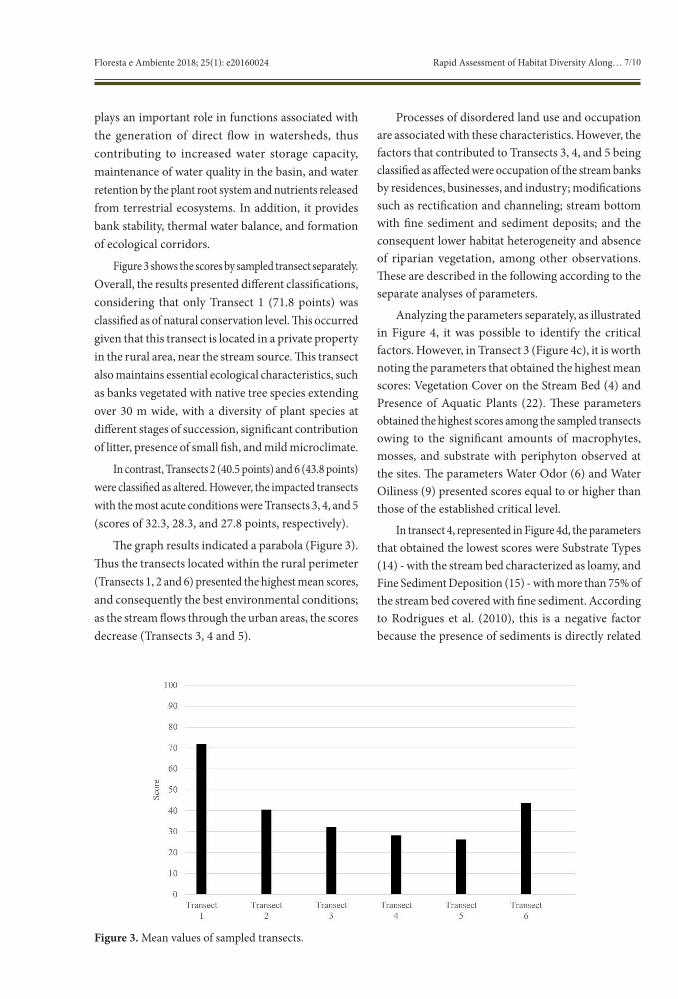
Figure 3 shows the scores by sampled transect separately. Overall, the results presented different classifications, considering that only Transect 1 (71.8 points) was classified as of natural conservation level. This occurred given that this transect is located in a private property in the rural area, near the stream source. This transect also maintains essential ecological characteristics, such as banks vegetated with native tree species extending over 30 m wide, with a diversity of plant species at different stages of succession, significant contribution of litter, presence of small fish, and mild microclimate.
In contrast, Transects 2 (40.5 points) and 6 (43.8 points) were classified as altered. However, the impacted transects with the most acute conditions were Transects 3, 4, and 5 (scores of 32.3, 28.3, and 27.8 points, respectively).
The graph results indicated a parabola (Figure 3). Thus the transects located within the rural perimeter (Transects 1, 2 and 6) presented the highest mean scores, and consequently the best environmental conditions; as the stream flows through the urban areas, the scores decrease (Transects 3, 4 and 5).
Processes of disordered land use and occupation are associated with these characteristics. However, the factors that contributed to Transects 3, 4, and 5 being classified as affected were occupation of the stream banks by residences, businesses, and industry; modifications such as rectification and channeling; stream bottom with fine sediment and sediment deposits; and the consequent lower habitat heterogeneity and absence of riparian vegetation, among other observations. These are described in the following according to the separate analyses of parameters.
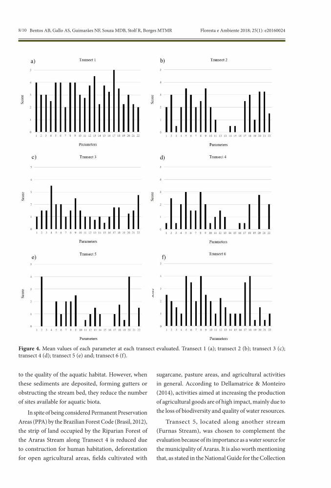
Analyzing the parameters separately, as illustrated in Figure 4, it was possible to identify the critical factors. However, in Transect 3 (Figure 4c), it is worth noting the parameters that obtained the highest mean scores: Vegetation Cover on the Stream Bed (4) and Presence of Aquatic Plants (22). These parameters obtained the highest scores among the sampled transects owing to the significant amounts of macrophytes, mosses, and substrate with periphyton observed at the sites. The parameters Water Odor (6) and Water Oiliness (9) presented scores equal to or higher than those of the established critical level.
In transect 4, represented in Figure 4d, the parameters that obtained the lowest scores were Substrate Types (14) - with the stream bed characterized as loamy, and Fine Sediment Deposition (15) - with more than 75% of the stream bed covered with fine sediment. According to Rodrigues et al. (2010), this is a negative factor because the presence of sediments is directly related
Figure 3. Mean values of sampled transects.
8/10 Bentos AB, Gallo AS, Guimarães NF, Souza MDB, Stolf R, Borges MTMR Floresta e Ambiente 2018; 25(1): e20160024
Figure 4. Mean values of each parameter at each transect evaluated. Transect 1 (a); transect 2 (b); transect 3 (c); transect 4 (d); transect 5 (e) and; transect 6 (f).
to the quality of the aquatic habitat. However, when these sediments are deposited, forming gutters or obstructing the stream bed, they reduce the number of sites available for aquatic biota.
In spite of being considered Permanent Preservation Areas (PPA) by the Brazilian Forest Code (Brasil, 2012), the strip of land occupied by the Riparian Forest of the Araras Stream along Transect 4 is reduced due to construction for human habitation, deforestation for open agricultural areas, fields cultivated with
sugarcane, pasture areas, and agricultural activities in general. According to Dellamatrice & Monteiro (2014), activities aimed at increasing the production of agricultural goods are of high impact, mainly due to the loss of biodiversity and quality of water resources.
Transect 5, located along another stream (Furnas Stream), was chosen to complement the evaluation because of its importance as a water source for the municipality of Araras. It is also worth mentioning that, as stated in the National Guide for the Collection
9/10Rapid Assessment of Habitat Diversity Along…Floresta e Ambiente 2018; 25(1): e20160024
and Preservation of Samples of CETESB (2011), it is necessary to include any possible areas that can influence the sampling of the water body. This transect presented the most critical environment according to the application of the RHDA protocol (Figure 4e). Characteristics predominant in urbanized areas were observed, such as nearby factories and industries, absence of riparian vegetation, and channeling of the banks. According to Palmer et al. (2005), the latter constitutes a problem because the rectification and channeling of rivers has as a direct consequence the reduction of the catchment area of river basins, causing a drastic decrease in the density and diversity of aquatic species.
Furthermore, the observation of greatest relevance gained through the application of the RHDA protocol was that the transects classified as affected (Transects 3, 4, and 5) are located in the urban area. This aspect reveals a greater negative influence of this land use on the watercourse. A similar situation was reported by Magini & Chagas (2003) when studying the same stream. There, they verified that the urban occupation of the banks and industrial activities were the main factors of impact.
Table 4 shows a comparison between the scores of each observer for the present study, confirming the low variation between assessments. It is worth mentioning that the observers who participated in this study had already conducted previous evaluations using the same tool. According to Rodrigues & Castro (2008), this increases the accuracy of the method.
The specific scientific literature has shown that, in general, assessment protocols present a common origin and have improved over time. Therefore, the protocols have developed consistent variables for the environmental analysis of watercourse banks because
they reflect what many researchers have considered important for impact assessment over the past decades.
Professional observers who begin to use rapid assessment protocols can focus on everything that this field of research has highlighted so far. Therefore, the method has a didactic function, as underlined by Callisto et al. (2002). Moreover, from the standpoint of the layperson, it is possible to acquire this clear and useful understanding, thereby justifying the advances in the use of the RHDA protocol.
4. CONCLUSIONS
Application of the RHDA protocol along part of the Araras Stream revealed a condition of concern with respect to the state of conservation of the lotic environment. The longitudinal transect sampled was classified as impacted and presented the following aggravating characteristics: occupation of the banks, presence of channeling and rectification, acute disruption of the riparian forest, cemented or loamy stream bed, impoverished habitat, absence of aquatic fauna, and erosive processes causing sedimentation of the stream bed.
The separate assessment of the transects identified the best environmental quality in a private property in the rural area, near the spring region. It also revealed that the regions most impacted by anthropogenic activities are located within the urban perimeter.
Application of the RHDA protocol in the micro basin of the Araras Stream proved to be simple, inexpensive, and capable of providing a holistic assessment of the aquatic ecosystem, presenting data that can be used in decision making for the management and conservation of water resources.
Table 4. RHDA protocol general rating by observer at each sampled transect (from Transects 1 to 6). Result comparison of four observers by the Turkey test at 5% probability, mean, and standard deviation.
Treatments(Observers)
Blocks (TRANSECTS)Transect
1Transect
2Transect
3Transect
4Transect
5Transect
6Treatment
meanObserver 1 64 46 43 22 37 20 44.5 AObserver 2 74 39 20 41 67 26 42.0 AObserver 3 76 45 26 32 40 33 38.7 AObserver 4 73 32 42 18 31 31 37.8 AMean/blocks 71.75 40.50 32.75 28.25 43.75 27.50 40.75Standard deviation 4.60 5.59 9.98 8.95 13.81 5.02 2.67Means with the same letters do not differ statistically by the Tukey test at 5% significance level.
10/10 Bentos AB, Gallo AS, Guimarães NF, Souza MDB, Stolf R, Borges MTMR Floresta e Ambiente 2018; 25(1): e20160024
SUBMISSION STATUS
Received: 4 feb., 2016 Accepted: 18 apr., 2017
CORRESPONDENCE TO
Adriel Barboza Bentos Programa de Pós-graduação em Agroecologia e Desenvolvimento Rural, Universidade Federal de São Carlos – UFSCar, Rodovia Anhanguera, Km 174, SP-330, CEP 13600-970, Araras, SP, Brazil e-mail: [email protected]
REFERENCES
Brasil. Lei nº 12.651, 25 de maio de 2012. Dispõe sobre a proteção da vegetação nativa e dá outras providências. Diário Oficial da República Federativa do Brasil, Brasília, DF (2012 may).
Callisto M, Ferreira WR, Moreno P, Goulart M, Petrucio M. Aplicação de um protocolo de avaliação rápida da diversidade de habitats em atividades de ensino e pesquisa (MG-RJ). Acta Limnologica Brasiliensia 2002; 14(1): 91-98.
Callisto M, Goulart M, Moretti M. Macroinvertebrados Bentônicos como Ferramenta para Avaliar a Saúde de Riachos. Revista Brasileira de Recursos Hídricos 2001; 6(1): 71-82. http://dx.doi.org/10.21168/rbrh.v6n1.p71-82.
Carvalho EM, Bentos AB, Pereira NS. Avaliação rápida da diversidade de habitats em um ambiente lótico. Interbio 2014; 8(1): 45-55.
Companhia Ambiental do Estado de São Paulo – CETESB. Guia nacional de coleta e preservação de amostras: água, sedimento, comunidades aquáticas e efluentes líquidos. São Paulo: CETESB; 2011.
Dellamatrice PM, Monteiro RTR. Principais aspectos da poluição de rios brasileiros por pesticidas. Revista Brasileira de Engenharia Agrícola e Ambiental 2014; 18(12): 1296-1301. http://dx.doi.org/10.1590/1807-1929/agriambi.v18n12p1296-1301.
Environmental Protection Agency – EPA. Biological criteria for the protection of aquatic life. Columbus: Division of Water Quality, Planning and Assessment, Surface Water Section; 1987.
Godoi EL. Monitoramento de água superficial densamente poluída: o Córrego Pirajuãra, região metropolitana de São Paulo, Brasil [dissertation]. São Paulo: Instituto de Pesquisas Energéticas e Nucleares; 2008.
Hannaford MJ, Barbour MT, Resh VH. Training reduces observer variability in visual-based assessments of stream
habitat. Journal of the North American Benthological Society 1997; 16(4): 853-860. http://dx.doi.org/10.2307/1468176.
Instituto Brasileiro de Geografia e Estatística – IBGE. Censo Demográfico 2010 [online]. Rio de Janeiro: IBGE; 2010. [cited 2015 July 18]. Available from: www.cidades.ibge.gov.br/xtras/perfil.php?codmun=350330
Magini C, Chagas RL. Microzoneamento e diagnóstico físico-químico do Ribeirão das Araras, SP. Geociências 2003; 22(2): 195-208.
Minatti-Ferreira DD, Beaumord AC. Avaliação rápida de integridade ambiental das sub-bacias do rio Itajaí-Mirim no Município de Brusque, SC. Revista Saúde & Ambiente 2004; 5(2): 21-27.
Palmer MA, Bernhardt ES, Allan JD, Lake PS, Alexander G, Brooks S et al. Standards for ecologically successful river restoration. Journal of Applied Ecology 2005; 42(2): 208-217. http://dx.doi.org/10.1111/j.1365-2664.2005.01004.x.
Plafkin JL, Barbour MT, Porter KD, Gross SK, Hughes RM. Rapid bioassessment protocols for use in streams and rivers: benthic macroinvertebrates and fish. Washington: EPA; 1989.
Projeto Ecoagri. Diagnóstico ambiental da agricultura em São Paulo: bases para um desenvolvimento rural sustentável. Campinas: FAPESP; 2006. Relatório III.
Resende M, Curi N, Rezende SB, Correa GF. Pedologia: base para distinção de ambientes. 5th ed. Lavras: Editora UFLA; 2007.
Rocha JSM. Manual de manejo integrado de bacias hidrográficas. Santa Maria: Universidade Federal de Santa Maria; 1991.
Rodrigues ASL, Castro PTA. Protocolos de avaliação rápida: instrumentos complementares no monitoramento dos recursos hídricos. Revista Brasileira de Recursos Hídricos 2008; 13(1): 161-170. http://dx.doi.org/10.21168/rbrh.v13n1.p161-170.
Rodrigues ASL, Malafaia G, Castro PTA. Avaliação ambiental de trechos de rios na região de Ouro Preto-MG através de um protocolo de avaliação rápida. Revista de Estudos Ambientais 2008; 10(1): 74-83.
Rodrigues ASL, Malafaia G, Castro PTA. A importância da avaliação do habitat no monitoramento da qualidade dos recursos hídricos: uma revisão. SaBios: Revista de Saúde e Biologia 2010; 5(1): 26-42.
Santos HG. Sistema brasileiro de classificação de solos. 2nd ed. Rio de Janeiro: Embrapa Solos; 2006.
Tundisi JG. Água no século XXI: enfrentando a escassez. 2rd ed. São Carlos: Rima; 2003.
Vogel HF, Zawadzki CH, Metri R. Florestas ripárias: importância e principais ameaças. Sabios: Revista Saúde e Biologia 2009; 4(1): 24-30.