Embed Size (px)
Citation preview

Versão online: http://www.lneg.pt/iedt/unidades/16/paginas/26/30/185 Comunicações Geológicas (2014) 101, Especial II, 615-619 IX CNG/2º CoGePLiP, Porto 2014 ISSN: 0873-948X; e-ISSN: 1647-581X
Amazonian mangrove dynamic based on indicators multi-proxy A dinâmica dos manguezais amazônicos baseada em indicadores multi-proxy M. C. França1,2*, M. I. Francisquini4, M. C. L. Cohen2,3, L. C. R. Pessenda4
© 2014 LNEG – Laboratório Nacional de Geologia e Energia IP
Abstract: The mangrove dynamic on Marajó Island at the mouth of the Amazon River during the past ~7500 cal yr BP was studied using multiple proxies, including sedimentary facies, pollen, δ13C, δ15N and C/N ratio, temporally synchronized with fifteen sediment samples to 14C dating. The results allowed to propose a palaeogeographical development with changes in vegetation, hydrology and organic matter dynamics. Today, the island’s interior is occupied by várzea/herbaceous vegetation (freshwater vegetation), but during the early-middle Holocene mangroves with accumulation of estuarine organic matter had colonized the tidal mud flats. This was caused by post-glacial sea-level rise, which combined with tectonic subsidence, produced a marine transgression. It is likely that the relatively higher marine influence at the studied area was favored by reduced Amazon River discharge, caused by a dry period occurred during the early and middle Holocene. During the late Holocene, there was a reduction of mangrove vegetation and the contribution of freshwater organic matter to the area was higher than early and middle Holocene. This suggests a decrease in marine influence during the late Holocene that led to a gradual migration of mangroves from the central region to the northeastern littoral zone of island, and, consequently, its isolation since at least ~1150 cal yr BP. Keywords: Coastal zone, Amazon River, Holocene, Sea-level, Vegetation, Climate change. Resumo: A dinâmica dos manguezais na Ilha de Marajó, foz do Rio Amazonas, durante o passado ~ 7500 anos cal AP foi estudada usando vários proxies, incluindo fácies sedimentares, grãos de pólen, δ13C, δ15N e relação C/N, temporalmente sincronizados com quinze datações 14C. Os resultados permitiram propor um desenvolvimento paleogeográfico com mudanças na vegetação, hidrologia e dinâmica da matéria orgânica. Hoje, o interior da Ilha é ocupado por vegetação de várzea/campos herbáceos de água doce, mas durante o Holoceno inicial houve um amplo desenvolvimento de manguezais com acúmulo de matéria orgânica estuarina. Isso foi causado devido aumento do nível do mar pós-glacial, e que combinado com uma subsidência tectônica, produziu uma transgressão marinha. É provável que a influência marinha relativamente maior na área estudada durante o Holoceno inicial e médio foi favorecida pela redução da descarga do Rio Amazonas, causada por um período de seca. Durante o final do Holoceno, houve uma redução da vegetação de mangue e da contribuição da matéria orgânica marinha. Isso sugere uma diminuição da influência marinha durante o Holoceno final que levou a uma migração gradual dos manguezais da região central para a zona litorânea nordeste da Ilha, causando um consequentemente isolamento dos manguezais pelo menos desde ~1150 anos cal AP. Palavras-chave: Zona costeira, Rio Amazonas, Holoceno, Nível do mar, Vegetação, Mudanças climáticas.
1Federal Institute of Pará, Av. Almirante Barroso, 1155, Marco, CEP 66090-020, Belém (PA), Brazil. 2Post-Graduate Program of Geology and Geochemistry, Laboratory of Coastal Dynamics, Federal University of Pará. Av. Perimentral 2651, Terra Firme, CEP: 66077-530, Belém (PA), Brazil. 3Faculty of Oceanography, Federal University of Pará, Rua Augusto Corrêa, n 1, Guama, CEP: 66075-110, Belém(PA), Brazil. 4University of São Paulo, 14C Laboratory, Avenida Centenário 303, 13400-000, Piracicaba, São Paulo, Brazil. *Corresponding author / Autor correspondente: [email protected]
1. Introduction
Mangrove distributions are considered indicators of coastal changes (Blasco et al., 1996) and have fluctuated throughout geological and human history. The area covered by mangrove is influenced by complex interactions involving gradients of tidal flooding frequency, nutrient availability and soil salt concentration across the intertidal area (Hutchings & Saenger, 1987; Wolanski et al., 1990).
Investigations along the littoral zone of the Brazilian Amazon using sedimentological, palynological and isotope data have revealed evidence of expansion/contraction of mangroves during the Holocene (Guimarães et al., 2012; Smith et al., 2012; Cohen et al., 2012). Those mangrove variations have been attributed to the combination of post-glacial sea-level rise (Suguio et al., 1985; Martin et al., 1996; Angulo et al., 2008), tectonic subsidence (Rossetti et al., 2012) and changes in the Amazon River discharge as consequence of variations in rainfall (Bush & Colinvaux, 1988; Bush et al., 2007).
The main objective of this investigation is to establish a relationship between the changes in estuarine salinity gradient from Amazon River and the mangrove dynamics of Marajó Island-Northern Brazil. Then, this work presents the integration of δ13C, δ15N, total organic carbon (TOC), C/N ratio, facies analysis and pollen data, synchronized chronologically with fifteen radiocarbon dated (14C) samples.
Artigo Curto Short Article
616 M. C. França et al. / Comunicações Geológicas (2014) 101, Especial II, 615-619
2. Materials and methods
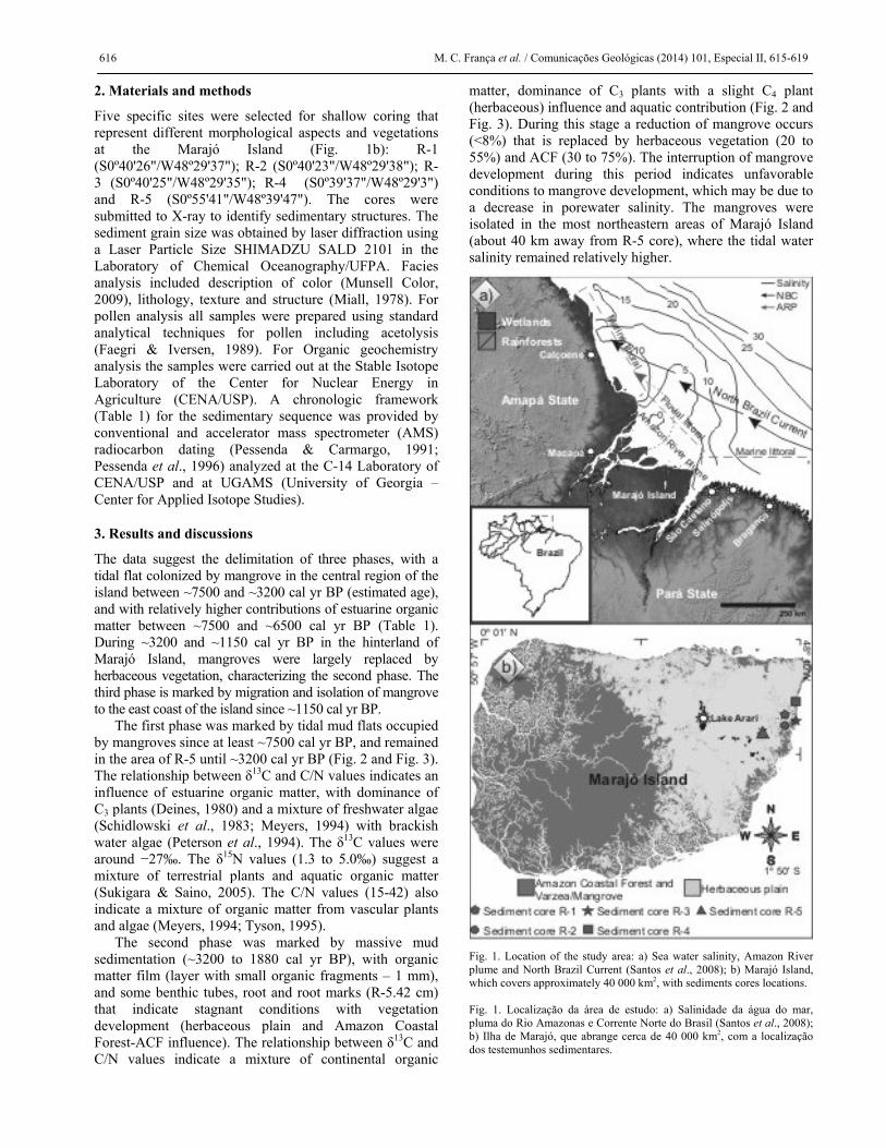
Five specific sites were selected for shallow coring that represent different morphological aspects and vegetations at the Marajó Island (Fig. 1b): R-1 (S0º40'26"/W48º29'37"); R-2 (S0º40'23"/W48º29'38"); R-3 (S0º40'25"/W48º29'35"); R-4 (S0º39'37"/W48º29'3") and R-5 (S0º55'41"/W48º39'47"). The cores were submitted to X-ray to identify sedimentary structures. The sediment grain size was obtained by laser diffraction using a Laser Particle Size SHIMADZU SALD 2101 in the Laboratory of Chemical Oceanography/UFPA. Facies analysis included description of color (Munsell Color, 2009), lithology, texture and structure (Miall, 1978). For pollen analysis all samples were prepared using standard analytical techniques for pollen including acetolysis (Faegri & Iversen, 1989). For Organic geochemistry analysis the samples were carried out at the Stable Isotope Laboratory of the Center for Nuclear Energy in Agriculture (CENA/USP). A chronologic framework (Table 1) for the sedimentary sequence was provided by conventional and accelerator mass spectrometer (AMS) radiocarbon dating (Pessenda & Carmargo, 1991; Pessenda et al., 1996) analyzed at the C-14 Laboratory of CENA/USP and at UGAMS (University of Georgia – Center for Applied Isotope Studies).
3. Results and discussions
The data suggest the delimitation of three phases, with a tidal flat colonized by mangrove in the central region of the island between ~7500 and ~3200 cal yr BP (estimated age), and with relatively higher contributions of estuarine organic matter between ~7500 and ~6500 cal yr BP (Table 1). During ~3200 and ~1150 cal yr BP in the hinterland of Marajó Island, mangroves were largely replaced by herbaceous vegetation, characterizing the second phase. The third phase is marked by migration and isolation of mangrove to the east coast of the island since ~1150 cal yr BP.
The first phase was marked by tidal mud flats occupied by mangroves since at least ~7500 cal yr BP, and remained in the area of R-5 until ~3200 cal yr BP (Fig. 2 and Fig. 3). The relationship between δ13C and C/N values indicates an influence of estuarine organic matter, with dominance of C3 plants (Deines, 1980) and a mixture of freshwater algae (Schidlowski et al., 1983; Meyers, 1994) with brackish water algae (Peterson et al., 1994). The δ13C values were around −27‰. The δ15N values (1.3 to 5.0‰) suggest a mixture of terrestrial plants and aquatic organic matter (Sukigara & Saino, 2005). The C/N values (15-42) also indicate a mixture of organic matter from vascular plants and algae (Meyers, 1994; Tyson, 1995).
The second phase was marked by massive mud sedimentation (~3200 to 1880 cal yr BP), with organic matter film (layer with small organic fragments – 1 mm), and some benthic tubes, root and root marks (R-5.42 cm) that indicate stagnant conditions with vegetation development (herbaceous plain and Amazon Coastal Forest-ACF influence). The relationship between δ13C and C/N values indicate a mixture of continental organic
matter, dominance of C3 plants with a slight C4 plant (herbaceous) influence and aquatic contribution (Fig. 2 and Fig. 3). During this stage a reduction of mangrove occurs (<8%) that is replaced by herbaceous vegetation (20 to 55%) and ACF (30 to 75%). The interruption of mangrove development during this period indicates unfavorable conditions to mangrove development, which may be due to a decrease in porewater salinity. The mangroves were isolated in the most northeastern areas of Marajó Island (about 40 km away from R-5 core), where the tidal water salinity remained relatively higher.
Fig. 1. Location of the study area: a) Sea water salinity, Amazon River plume and North Brazil Current (Santos et al., 2008); b) Marajó Island, which covers approximately 40 000 km2, with sediments cores locations. Fig. 1. Localização da área de estudo: a) Salinidade da água do mar, pluma do Rio Amazonas e Corrente Norte do Brasil (Santos et al., 2008); b) Ilha de Marajó, que abrange cerca de 40 000 km2, com a localização dos testemunhos sedimentares.

A mangrove dynamic based on multi-proxy 617
Fig. 2. Summary results for cores: variation as a function of cores depth from chronological, lithological profile, pollen analysis and geochemical variables. Binary diagram between δ13C x C/N for different zones data of organic matter preserved along the facies association Mangrove tidal flat (modified from Lamb et al., 2006). Fig. 2. Síntese dos resultados dos testemunhos: variação em função da profundidade dos resultados das datações, perfil litológico, resultados polínicos e variáveis geoquímicas. Diagrama binário entre δ13C x C/N para diferentes zonas de dados de matéria orgânica preservada ao longo da associação de fácies de uma planície de maré com manguezal (modificado de Lamb et al., 2006).
The third phase was marked by foreshore facies association (R-4, Fig. 2) recorded between ~1700 and ~600 cal yr BP. This period is marked by low TOC and absence of pollen. It may be caused by various external factors (sediment grain size, microbial attack, oxidation and mechanical forces), as well as factors inherent to the pollen grains themselves (sporopollenine content, chemical and physical composition of the pollen wall) (Havinga, 1967). The δ13C values (around −26‰) may indicate continental C3 plants (Deines, 1980) and/or freshwater algae (Schidlowski et al., 1983; Meyers, 1994). The mangrove began since ~1150 cal yr BP (R-2) at the earliest, and is recorded in cores R-1, R-4 and R-3 at ~540, ~580 and ~660 cal yr BP, respectively. During the last thousand years the relationship between δ13C and C/N shows a trend from continental organic matter to organic matter originating from estuarine algae during mangrove establishment.
Fig. 3. Schematic representation of successive phases of sediment accumulation and vegetation change in the study area according to marine-freshwater influence gradient. Fig. 3. Representação esquemática de sucessivas fases de acumulação de sedimentos e alteração da vegetação na área de estudo de acordo com a variação da influência de águas marinhas e água doce.

618 M. C. França et al. / Comunicações Geológicas (2014) 101, Especial II, 615-619
Table 1Sediment samples selected for Radiocarbon dating with depth, δ13C, 14C conventional and calibrated ages (using Calib 6.0; Reimer et al.,
2009).
Tabela 1. Amostras de sedimento selecionadas para datação por radiocarbono com a respectiva profundidade, δ13C e idades convencionais
de 14C calibradas (usando Calib 6.0; Reimer et al., 2009).
4. Conclusions
The sediment deposits from Marajó Island offer a valuable opportunity to investigate past climate and RSL, and its effects on vegetation and sedimentary organic matter. The data indicate a tidal mud flat colonized by mangroves with estuarine organic matter in the interior of Marajó Island between ~7500 and ~3200 cal yr BP. It was caused by the post-glacial sea-level rise, which combined with tectonic subsidence, produced a marine transgression. During the late Holocene, there was a reduction of mangrove vegetation in the interior of Marajó Island and the contribution of freshwater organic matter was higher than during the early and middle Holocene. It suggests a decrease in marine influence that led to a gradual migration of mangroves from the central region to the northeastern littoral, and consequently, its isolation since at least ~1150 cal yr BP.
As reported by this work, using a combination of proxies is efficient for establish a relationship between changes in estuarine salinity gradient and depositional environment/vegetation.
Acknowledgement
This study was financed by FAPESPA (Project 104/2008), CNPq (Project 473635/2012-7) and FAPESP (Project 03615-5/2007). The first author holds a scholarship from CNPq (Process 202598/2011-0).
References Angulo, R.J., de Souza, M.C., Assine, M.L., Pessenda, L.C.R., Disaró,
S.T., 2008. Chronostratigraphy and radiocarbon age inversion in the Holocene regressive barrier of Paraná, southern Brazil. Marine Geology, 252, 111-119.
Blasco, F., Saenger, P., Janodet, E., 1996. Mangrove as indicators of coastal change. Catena, 27, 167-178.
Bush, M.B., Colinvaux, P.A., 1988. A 7000-year pollen record from the Amazon lowlands, Ecuador. Vegetation, 76, 141-154.
Bush, M.B., Silman, M.R., Listopad, C.M.C.S., 2007. A regional study of Holocene climate change and human occupation in Peruvian Amazonia. Journal of Biogeography, 34, 1342-1356.
Cohen, M.C.L., Pessenda, L.C.R., Behling, H., Rossetti, D.F., França, M.C., Guimarães, J.T.F., Friaes, Y., Smith, C.B., 2012. Holocene palaeoenviromental history of the Amazonian mangrove belt. Quaternary Science Reviews, 55, 50-58.
Deines, P., 1980. The isotopic composition of reduced organic carbon. In: P. Fritz, J.C. Fontes, (Eds). Handbook of Environmental Isotope Geochemistry. The Terrestrial Environments, Vol. 1, Amsterdam: Elsevier, 329-406.
Faegri, K., Iversen, J., 1989. Textbook of Pollen Analysis, 4th. John.Wiley and Sons, Chichester, 328 p.
Guimarães, J.T.F., Cohen, M.C.L., Pessenda, L.C.R., França, M.C., Smith, C.B., Nogueira, A.C.R., 2012. Mid- and late-Holocene sedimentary process and palaeovegetation changes near the mouth of the Amazon River. The Holocene, 22, 359-370.
Havinga, A.J., 1967. Palynology and pollen preservation. Review of Paleobotany and Palynology, 2, 81-98.
Hutchings, P., Saenger, P., 1987. Ecology of Mangroves. Queensland University Press, St. Lucia, Qld., Australia and New York, 370 p.
Lamb, A.L., Wilson, G.P., Leng, M.J., 2006. A review of coastal palaeoclimate and relative sea-level reconstructions using δ13C and C/N ratios in organic material. Earth-Science Reviews, 75, 29-57.
Martin, L., Suguio, K., Flexor, J-M., Dominguez, J.M.L., Bittencourt, A.C.S.P., 1996. Quaternary Sea-level History and Variation in Dynamics along the Central Brazilian Coast: Consequences on Coastal Plain Construction. Anais da Academia Brasileira de Ciências, 68, 303-354.
Meyers, P.A., 1994. Preservation of elemental and isotopic source identification of sedimentary organic matter. Chemical Geology, 114, 289-302.
Miall, A.D., 1978. Facies types and vertical profile models in braided river deposits: a summary. In: A.D. Miall, (Ed.). Fluvial sedimentology. Canadian Society of Petroleum Geologists, Calgary, 597-604.
Munsell Color, 2009. Munsell Soil Color Charts. New Revised Edition. New Windsor, NY: Macbeth Division of Kollmorgen Instruments.
Pessenda, L.C.R., Camargo, P.B., 1991. Datação radiocarbônica de amostras de interesse arqueológico e geológico por espectrometria de cintilação líquida de baixo nível de radiação de fundo. Química Nova, 14, 98-103.
Pessenda, L.C.R., Valencia, E.P.E., Martinelli, L.A., 1996. 14C measurements in tropical soil developed on basic rocks. Radiocarbon, 38, 203-208.
Peterson, B.J., Fry, B., Hullar, M., Saupe, S., Wright, R., 1994. The distribution and stable carbon isotope composition of dissolved organic carbon in estuaries. Estuaries, 17, 111-121.
Reimer, P.J., Baillie, M.G.L., Bard, E., Bayliss, A., Beck, J.W., Blackwell, P.G., Bronk Ramsey, C., Buck, C.E., Burr, G.S., Edwards, R.L., Friedrich, M., Grootes, P.M., Guilderson, T.P., Hajdas, I., Heaton, T.J., Hogg, A.G., Hughen, K.A., Kaiser, K.F., Kromer, B., Mccormac, F.G., Manning, S.W., Reimer, R.W., Richards, D.A., Southon, J.R., Talamo, S., Turney, C.S.M., Van der Plicht, J., Weyhenmeyer, C.E., 2009. IntCal09 and Marine09 radiocarbon age calibration curves, 0-50,000 years cal BP. Radiocarbon, 51, 1111-1150.
Rossetti, D.F., Souza, L.S.B., Prado, R., Elis, V.R., 2012. Neotectonics in the northern equatorial Brazilian margin. Journal of South American Earth Sciences, 37, 175-190.
Santos, M.L.S., Medeiros, C., Muniz, K., Feitosa, F.A.N., Schwamborn, R., Macedo, S.J., 2008. Influence of the Amazon and Pará Rivers on water composition and phyto-plankton biomass on the adjacent shelf. Journal of Coastal Research, 24, 585–593.
A mangrove dynamic based on multi-proxy 619 Schidlowski, M., Hayes, J.M., Kaplan, I.R., 1983. Isotopic inferences
of ancient biochemistries: Carbon, sulphur, hydrogen and nitrogen. In: J.W. Scholf, (Ed.), Earth’s Earliest Biosphere, Its Origin and Evolution. Princeton: Princeton University Press, 149-186.
Smith, C.B., Cohen, M.C.L., Pessenda, L.C.R., França, M.C., Guimarães, J.T.F., 2012. Holocenic proxies of sedimentary organic matter and the evolution of Lake Arari-Northern Brazil. Catena, 90, 26-38.
Suguio, K., Martin, L., Bittencourt, A.C.S.P., Dominguez, J.M.L., Flexor, J.M., Azevedo, A.E.G., 1985. Flutuações do Nível do Mar durante o Quaternário Superior ao longo do Litoral Brasileiro e suas
Implicações na Sedimentação Costeira. Revista Brasileira de Geociência, 15, 273-286.
Sukigara, C., Saino, T., 2005. Temporal variations of δ13C and δ15N in organic particles collected by a sediment trap at time-series station off the Tokyo Bay. Continental Shelf Research, 25, 1749-1767.
Tyson, R.V., 1995. Sedimentary Organic Matter: Organic Facies and Palynofacies. London: Chapman and Hall, 615 p.
Wolanski, E., Mazda, Y., King, B., Gay, S., 1990. Dynamics, flushing and trapping in Hinchinbrook channel, a giant mangrove swamp, Australia. Estuarine, Coastal and Shelf Science, 31, 555-579.