Embed Size (px)
Citation preview

ANAIS do 34º Congresso Brasileiro de Espeleologia Ouro Preto SP, 13-18 de junho de 2017 - ISSN 2178-2113 (online)
O artigo a seguir é parte integrando dos Anais do 34º Congresso Brasileiro de Espeleologia disponível gratuitamente em www.cavernas.org.br/34cbeanais.asp
Sugerimos a seguinte citação para este artigo: RIBEIRO, T. G. R.; et al.. Contexto estrutural no desenvolvimento da Caverna Tamboril, Unaí-MG. In: RASTEIRO, M.A.; TEIXEIRA-SILVA, C.M.; LACERDA, S.G. (orgs.) CONGRESSO BRASILEIRO DE ESPELEOLOGIA, 34, 2017. Ouro Preto. Anais... Campinas: SBE, 2017. p.297-300. Disponível em: <http://www.cavernas.org.br/anais34cbe/34cbe_297-300.pdf>. Acesso em: data do acesso.
A publicação dos Anais do 34º CBE contou com o apoio do Instituto Brasileiro de Mineração. Acompanhe a cooperação SBE-IBRAM em www.cavernas.org.br/sbe-ibram
Esta é uma publicação da Sociedade Brasileira de Espeleologia. Consulte outras obras disponíveis em www.cavernas.org.br

ANAIS do 34º Congresso Brasileiro de Espeleologia Ouro Preto MG, 13-18 de junho de 2017 – Sociedade Brasileira de Espeleologia
------------------------------------------------------------------------------------ -------------------------------------------------------------------------------------- www.cavernas.org.br [email protected]
297
CONTEXTO ESTRUTURAL NO DESENVOLVIMENTO DA CAVERNA
TAMBORIL, UNAÍ-MG
STRUCTURAL CANTEXT IN THE DEVELOPMENT OF TAMBORIL CAVE, UNAÍ-MG
Tulio G. R. RIBEIRO (1,2); Gabriel Castro de Oliveira DOMINGUES (2); Lucas Pedrosa
SOARES(2); André C. SOUZA (1,2)
(1) Grupo de Espeleologia da Geologia da Universidade de Brasília- GREGEO-UnB, Brasília DF.
(2) Universidade de Brasília, Brasília DF.
Contatos: [email protected]; [email protected]; [email protected].
Resumo
A região de Unaí-MG encontra-se localizada no contexto geológico da Faixa de Dobramentos Brasília. É
nesse contexto, sobre rochas carbonáticas do Grupo Bambuí (CPRM, 2014) que a Caverna Tamboril se
estabeleceu. A estruturação NE-SW de desenvolvimento da caverna segue o mesmo padrão de lineamentos
regionais. O controle da dissolução se deu principalmente ao longo de zona de charneira variando de NE a
NW em uma dobra antiforme isoclinal e fraturamentos associados.
Palavras-Chave: caverna Tamboril; dobra; fratura.
Abstract
The Unaí region in the state of Minas-Gerais is located at the geological context Brasília Fold Belt, central
part of Brazil. Was in this context that carbonatic rocks of Bambuí Group were dissolved generating the
Tamboril Cave. The NE-SW main development of the cave follows the regional pattern of lineaments. The
dissolution control occurred mainly along hinge zone of antiformal folds varying between NE to NW
directions under an isoclinal antiform.
Key-words: Tamboril cave; fold; fracture.
1. INTRODUÇÃO
This study has the proposal to present a
previous interpretation of how dissolution
preferably dissolved the carbonatic host rock of
Tamboril Cave, in Unaí region, 155 km of Brasilia
(Figure 1).
According with the topographic map of the
cave constructed by GREGEO, is notable a curved
main orientation that starts with NW-SE, changing
for approximately N-S and ending with NE-SW
direction (Figure 2).
Previous studies of the area emphasized the
well marked NE trend of lineaments (Laranjeira,
1992; Laranjeira & Dardenne, 1990). They also
suggested the presence of thrust and strike-slip
faults associated with isoclinal folds verging to the
east.
In the region, some authors emphasize the
difficulties to make stratigraphic correlations due
the complexity of the fault/folded system
(Laranjeira & Dardenne, 1990). The geological
mapping realized by CPRM, 2017 suggests that the
dolomitic and pelitic rocks are “doubtfully”
associated to the Bambuí Group.
Figure 1: Schematic map showing the location of
Tamboril Cave. Black point represents the entrances of
the cavity.

ANAIS do 34º Congresso Brasileiro de Espeleologia Ouro Preto MG, 13-18 de junho de 2017 – Sociedade Brasileira de Espeleologia
------------------------------------------------------------------------------------ -------------------------------------------------------------------------------------- www.cavernas.org.br [email protected]
298
Figure 2: Left: Some atitudes measured on the hill and abandoned mine;
Right: Tamboril Cave positioning in relation to the hill.
2. OBJECTIVES AND METHODOLOGY
The structural analysis of this project was
suggested by the master degree “Geological and
geochemical modeling of superficial infiltration of
water in the Tamboril Cave: Implication for
paleoclimatic interpretation.”, by the same author.
The path taken by superficial water is important
because the water can be biased by anomalous
contents of isotopes, leading to misinterpretations
(Wortham et al., 2017). For instance, we can note
anomalous values of Sr in the dripping water
collected from siltstones layers.
In first place an schematic map of lineaments
utilizing Google and digital elevation model of
elevation (SRTM images) (Figure 3) were made to
assist in the comprehension the understanding of the
structural trends. The geologic context of the area
was based on the bibliographic review, field
observations and mapping.
Figure 3: Map of lineaments of the region north of Unaí-MG.

ANAIS do 34º Congresso Brasileiro de Espeleologia Ouro Preto MG, 13-18 de junho de 2017 – Sociedade Brasileira de Espeleologia
------------------------------------------------------------------------------------ -------------------------------------------------------------------------------------- www.cavernas.org.br [email protected]
299
The next step was to understand how the
layers and fractures in general are structured,
measures were made inside, outside the cave, and
also in the abandoned mine in the southwest face of
the hill.
After collecting the structural data, an
simplistic model was constructed utilizing the
software 3D-Move (Figure 4).
3. DISCUSSIONS AND RESULTS
Measures done on the surface (outside the
hill) suggest that the mean attitude of the layers is
approximately 260°/45°. Is important to emphasize
that high dip layers like 235°/82° sometimes are
inverted, defined by upside down stromatolites.
This model indicates that the bedding is
folded in isoclinal system (Figure 5). Inside the cave
is notable that the preferential direction southward is
aligned with the hinge zone (in the lake hall the
azimuth is 185°) of an anticlinal tight fold. In the
ceiling of the same hall was observed a big fracture
with azimuth direction of 280°-100°. This fracture
in special present great amount of dissolution
speleothems like stalactites and curtains, which may
represent a good vector of percolation. Normal
faults were also seen (Figure 6) in the walls of the
cave, probably associated with late phase of
relaxation of the main tension.
Figure 4: Geological model of the layers. Note isoclinal pattern with inverted bedding.
Figure 5: Schematic cross-section adapted from Laranjeira & Dardenne, 1990.
Note the structural setting of isoclinal folds where Tamboril Cave is located.
ANAIS do 34º Congresso Brasileiro de Espeleologia Ouro Preto MG, 13-18 de junho de 2017 – Sociedade Brasileira de Espeleologia
------------------------------------------------------------------------------------ -------------------------------------------------------------------------------------- www.cavernas.org.br [email protected]
300
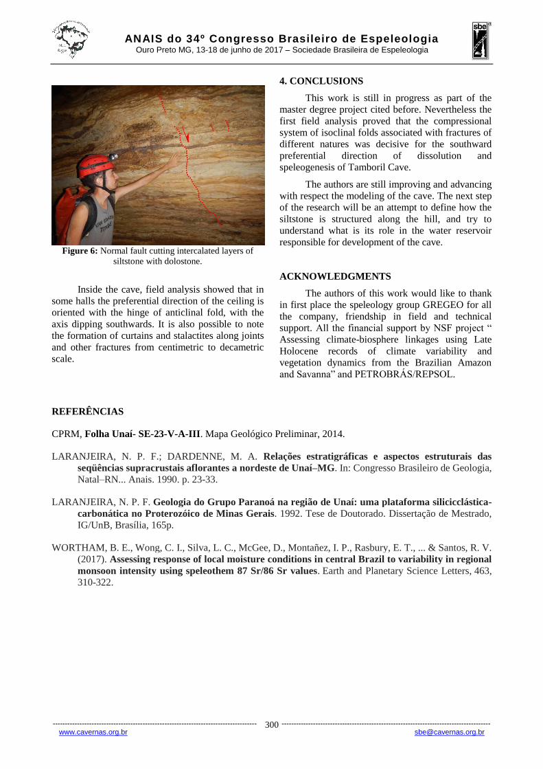
Figure 6: Normal fault cutting intercalated layers of
siltstone with dolostone.
Inside the cave, field analysis showed that in
some halls the preferential direction of the ceiling is
oriented with the hinge of anticlinal fold, with the
axis dipping southwards. It is also possible to note
the formation of curtains and stalactites along joints
and other fractures from centimetric to decametric
scale.
4. CONCLUSIONS
This work is still in progress as part of the
master degree project cited before. Nevertheless the
first field analysis proved that the compressional
system of isoclinal folds associated with fractures of
different natures was decisive for the southward
preferential direction of dissolution and
speleogenesis of Tamboril Cave.
The authors are still improving and advancing
with respect the modeling of the cave. The next step
of the research will be an attempt to define how the
siltstone is structured along the hill, and try to
understand what is its role in the water reservoir
responsible for development of the cave.
ACKNOWLEDGMENTS
The authors of this work would like to thank
in first place the speleology group GREGEO for all
the company, friendship in field and technical
support. All the financial support by NSF project “
Assessing climate-biosphere linkages using Late
Holocene records of climate variability and
vegetation dynamics from the Brazilian Amazon
and Savanna” and PETROBRÁS/REPSOL.
REFERÊNCIAS
CPRM, Folha Unaí- SE-23-V-A-III. Mapa Geológico Preliminar, 2014.
LARANJEIRA, N. P. F.; DARDENNE, M. A. Relações estratigráficas e aspectos estruturais das
seqüências supracrustais aflorantes a nordeste de Unaí–MG. In: Congresso Brasileiro de Geologia,
Natal–RN... Anais. 1990. p. 23-33.
LARANJEIRA, N. P. F. Geologia do Grupo Paranoá na região de Unaí: uma plataforma silicicclástica-
carbonática no Proterozóico de Minas Gerais. 1992. Tese de Doutorado. Dissertação de Mestrado,
IG/UnB, Brasília, 165p.
WORTHAM, B. E., Wong, C. I., Silva, L. C., McGee, D., Montañez, I. P., Rasbury, E. T., ... & Santos, R. V.
(2017). Assessing response of local moisture conditions in central Brazil to variability in regional
monsoon intensity using speleothem 87 Sr/86 Sr values. Earth and Planetary Science Letters, 463,
310-322.