Embed Size (px)
Citation preview
1
UNIVERSIDADE FEDERAL DO PARÁ INSTITUTO DE GEOCIÊNCIAS
PROGRAMA DE PÓS-GRADUAÇÃO EM GEOLOGIA E GEOQUÍMICA
TESE DE DOUTORADO Nº 97
DESENVOLVIMENTO DA VEGETAÇÃO E MORFOLOGIA DA FOZ DO AMAZONAS-PA E RIO DOCE-ES DURANTE O
QUATERNÁRIO TARDIO
Tese apresentada por:
MARLON CARLOS FRANÇA Orientador: Prof. Dr. Marcelo Cancela Lisboa Cohen (UFPA) Coorientador: Prof. Dr. Luiz Carlos Ruiz Pessenda (CENA/USP)
BELÉM
2013
Dados Internacionais de Catalogação-na-Publicação (CIP) Sistema de Bibliotecas da UFPA
F798d França, Marlon Carlos
Desenvolvimento da vegetação e morfologia da foz do Amazonas-PA e rio Doce-ES durante o Quaternário tardio / Marlon Carlos França; Orientador: Marcelo Cancela Lisboa Cohen; Co-orientador: Luiz Carlos Ruiz Pessenda – 2013
Tese (doutorado em geologia) – Universidade Federal do Pará,
Instituto de Geociências, Programa de Pós-Graduação em Geologia e Geoquímica, Belém, 2012.
1. Sedimentologia – Pará. 2. Sedimentologia – Espírito Santo. 3.
Estratigrafia. 4. Palinologia. 5. Quaternário. 6. Planícies de mare. I. Cohen, Marcelo Cancela Lisboa, orient. II. Universidade Federal do Pará. III. Título.
CDD 22ª ed.: 551.3098115

V niversidade Federal do Pará 9!1iil!~ Instituto de Geociências
Programa de Pós-Graduação em eologia e Geoquímica
DESENVOLVIMENTO DA VEGETAÇÃ E MORFOLOGIA DA FOZ DO AMAZONAS-PA E RIO DO E-ES DURANTE O
QUATERNÁRIO TARD O
TESE APRESENTADA PO
MARLONCARLOSFRA ÇA
Como requisito parcial à obtenção do Grau de Doutor em Ciê cias na Área de GEOLOGIA
Data da aprovação: 05/11/2013
Banca Examinadora:

Dedico este trabalho aos meus pais Franco e Lene, aos
meus irmãos Fabrycio, Brandon, Christopher e Glayson (in
memoriam), à minha amada esposa Renata França e meus amados
filhos Maria Clara e Yuri.
AGRADECIMENTOS
Expresso aqui meu total agradecimento a Deus, por toda força e proteção que tem me
concedido durante todos os dias da minha vida e, à minha família, por todo apoio e
honestidade.
Agradeço ao meu orientador Prof. Dr. Marcelo Cancela Lisboa Cohen (UFPA), co-
orientadores Prof. Dr. Luiz Carlos Ruiz Pessenda (USP) e Prof. Dr. Raymond S. Bradley
(UMASS/Amherst), por todo o conhecimento científico e social transferido, por todas as
discussões e sugestões, além dos incentivos diários para a composição deste e dos futuros
trabalhos.
Aos amigos do PPGG e Biblioteca do Instituto de Geociências da UFPA, Cleida
Freitas, Lúcia de Sousa e Hélio.
Aos Professores Dra. Dilce de Fátima Rossetti (INPE), Dr. Paulo C. F. Giannini
(USP), Dr. Jolimar A. Schiavo (UEMS), Dra. Susy Eli Marques Gouveia e ao Dr. Franklin N.
Santos pela amizade, por toda orientação nas atividades de campo, coleta dos testemunhos,
atividades de laboratório e conhecimento transferido.
Aos amigos e professores do Instituto Federal do Pará, MSc. Osvaldo Teixeira, Dr.
Maurício Zorro, MSc. Ruth Amanda, Dr. Roberto Vilhena, MSc. Pâmela Costa, MSc. Rayette
Silva, Dr. Carlos Rocha, por todo apoio.
Aos amigos e profissionais do Laboratório de Dinâmica Costeira (LADIC), da
Universidade Federal do Pará, Dr. José Tasso Felix Guimarães (VALE), Dra. Clarisse Beltrão
Smith (UEPA), MSc. Yuri Friaes (PPGG/UFPA), MSc. Igor C. C. Alves (PPGG/UFPA) pela
amizade, dedicação, sugestões e auxílio nos trabalhos de campo e laboratório. À Cleida
Freitas pela amizade e eficiência profissional nos assuntos do PPGG/UFPA.
Aos amigos e profissionais do Laboratório de 14C (CENA/USP), MSc. Antônio
Álvaro Buso Junior, MSc. Marcos A. Borotti Filho, MSc. Mariah I. Francisquini, MSc. Flávio
L. Lorente, Thiago Barros, Liz Mary, Fernanda Torquetti W. Lima e Dra. Darciléa F. Castro,
por todo apoio nas atividades de campo e laboratório para a construção deste trabalho.
Aos membros do Department of Geoscience, UMass/Amherst, Dr. Michael Rawlins,
Dra. Donna Francis, Dr. Mark Leckie, Dr. John Woodruff, Dra. Addie Rose Holland, Dr.
Nick Balascio, Dra. Fangxing Fan, Dr. Liang Ning, MSc. Anthony Coletti, MSc. Samuel
Davin, MSc. Gregory Dewet, MSc. Chantelle Lonsdale, MSc. Jeremy Wei, Ben Pelto, Laura
Bishop, George Drake, Jenn Nikonczyk, Lorna Stinchfield e Nancy Condon, por toda
amizade e apoio durante o desenvolvindo dos trabalhos nos Estados Unidos.
Aos profissionais da Jones Library (Amherst/MA), Lew Hortzman, Lynne Weintraub
e Tina Swift por todo carinho, amizade e apoio nos ensinamentos e revisões do Inglês.
Aos revisores anônimos das revistas científicas, obrigado por todos os
questionamentos e sugestões, que colaboraram de forma construtiva para este trabalho.
À Universidade Federal do Pará (Programa de Pós-Graduação em Geologia e
Geoquímica), pela disponibilidade de espaço e laboratórios.
Ao Instituto Federal de Educação, Ciência e Tecnologia do Pará, pela confiança e
apoio no desenvolvimento deste trabalho.
À University of Massachusetts, Climate System Research Center, Department of
Geosciences pela concessão de espaço e utilização dos laboratórios.
Ao CNPq pelo apoio financeiro (473635/2012-7) e concessão da bolsa de estudos
(Doutorado Sanduíche - 202598/2011-0) nesta pesquisa.
À Fundação de Amparo à Pesquisa do Estado do Pará (FAPESPA), pelo
financiamento do projeto de pesquisa (104/2008)
À Fundação de Amparo à Pesquisa do Estado de São Paulo (FAPESP), pelo
financiamento do projeto de pesquisa (03615-5/2007 e 00995-7/2011).
Ao Centro de Energia Nuclear Aplicado à Agricultura (CENA-USP) e Laboratório
de 14C.
Ao Laboratório e Oceanografia Química (LOQ-UFPA) e ao Laboratório de Dinânica
Costeira da Universidade Federal do Pará (LADIC-UFPA).
À Reserva Natural Vale (Linhares – ES), pelo acolhimento e suporte durante as
atividades de campo no Espírito Santo.
Agradeço novamente de forma especial à minha família, que tanto amo, por todo
apoio e carinho durante a construção deste trabalho. À minha amada esposa Renata de Castro
Ribeiro França, meus filhos Maria Clara e Yuri, meus pais Franco França e Valdilene Alves,
meus irmãos Fabrycio França, Glayson França (in memoriam) Brandon França e Christopher
França, minha sogra Carmem S. R. do Carmo e meu sogro Paulo da Cruz Castro.
Muito obrigado!
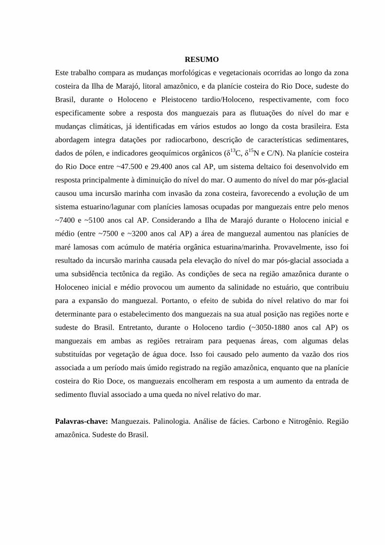
RESUMO
Este trabalho compara as mudanças morfológicas e vegetacionais ocorridas ao longo da zona
costeira da Ilha de Marajó, litoral amazônico, e da planície costeira do Rio Doce, sudeste do
Brasil, durante o Holoceno e Pleistoceno tardio/Holoceno, respectivamente, com foco
especificamente sobre a resposta dos manguezais para as flutuações do nível do mar e
mudanças climáticas, já identificadas em vários estudos ao longo da costa brasileira. Esta
abordagem integra datações por radiocarbono, descrição de características sedimentares,
dados de pólen, e indicadores geoquímicos orgânicos (δ13C, δ15N e C/N). Na planície costeira
do Rio Doce entre ~47.500 e 29.400 anos cal AP, um sistema deltaico foi desenvolvido em
resposta principalmente à diminuição do nível do mar. O aumento do nível do mar pós-glacial
causou uma incursão marinha com invasão da zona costeira, favorecendo a evolução de um
sistema estuarino/lagunar com planícies lamosas ocupadas por manguezais entre pelo menos
~7400 e ~5100 anos cal AP. Considerando a Ilha de Marajó durante o Holoceno inicial e
médio (entre ~7500 e ~3200 anos cal AP) a área de manguezal aumentou nas planícies de
maré lamosas com acúmulo de matéria orgânica estuarina/marinha. Provavelmente, isso foi
resultado da incursão marinha causada pela elevação do nível do mar pós-glacial associada a
uma subsidência tectônica da região. As condições de seca na região amazônica durante o
Holoceneo inicial e médio provocou um aumento da salinidade no estuário, que contribuiu
para a expansão do manguezal. Portanto, o efeito de subida do nível relativo do mar foi
determinante para o estabelecimento dos manguezais na sua atual posição nas regiões norte e
sudeste do Brasil. Entretanto, durante o Holoceno tardio (~3050-1880 anos cal AP) os
manguezais em ambas as regiões retrairam para pequenas áreas, com algumas delas
substituídas por vegetação de água doce. Isso foi causado pelo aumento da vazão dos rios
associada a um período mais úmido registrado na região amazônica, enquanto que na planície
costeira do Rio Doce, os manguezais encolheram em resposta a um aumento da entrada de
sedimento fluvial associado a uma queda no nível relativo do mar.
Palavras-chave: Manguezais. Palinologia. Análise de fácies. Carbono e Nitrogênio. Região
amazônica. Sudeste do Brasil.
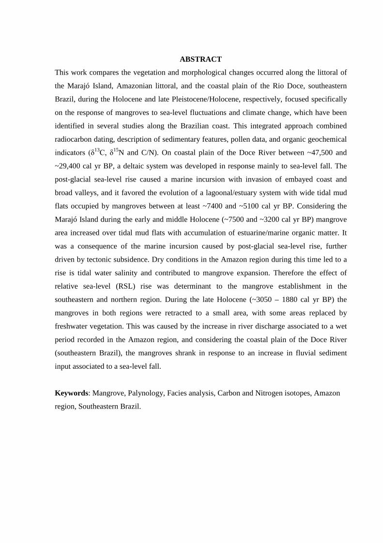
ABSTRACT
This work compares the vegetation and morphological changes occurred along the littoral of
the Marajó Island, Amazonian littoral, and the coastal plain of the Rio Doce, southeastern
Brazil, during the Holocene and late Pleistocene/Holocene, respectively, focused specifically
on the response of mangroves to sea-level fluctuations and climate change, which have been
identified in several studies along the Brazilian coast. This integrated approach combined
radiocarbon dating, description of sedimentary features, pollen data, and organic geochemical
indicators (δ13C, δ15N and C/N). On coastal plain of the Doce River between ~47,500 and
~29,400 cal yr BP, a deltaic system was developed in response mainly to sea-level fall. The
post-glacial sea-level rise caused a marine incursion with invasion of embayed coast and
broad valleys, and it favored the evolution of a lagoonal/estuary system with wide tidal mud
flats occupied by mangroves between at least ~7400 and ~5100 cal yr BP. Considering the
Marajó Island during the early and middle Holocene (~7500 and ~3200 cal yr BP) mangrove
area increased over tidal mud flats with accumulation of estuarine/marine organic matter. It
was a consequence of the marine incursion caused by post-glacial sea-level rise, further
driven by tectonic subsidence. Dry conditions in the Amazon region during this time led to a
rise is tidal water salinity and contributed to mangrove expansion. Therefore the effect of
relative sea-level (RSL) rise was determinant to the mangrove establishment in the
southeastern and northern region. During the late Holocene (~3050 – 1880 cal yr BP) the
mangroves in both regions were retracted to a small area, with some areas replaced by
freshwater vegetation. This was caused by the increase in river discharge associated to a wet
period recorded in the Amazon region, and considering the coastal plain of the Doce River
(southeastern Brazil), the mangroves shrank in response to an increase in fluvial sediment
input associated to a sea-level fall.
Keywords: Mangrove, Palynology, Facies analysis, Carbon and Nitrogen isotopes, Amazon
region, Southeastern Brazil.
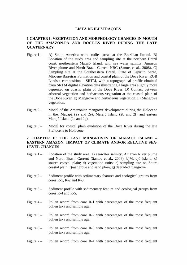
LISTA DE ILUSTRAÇÕES
1 CHAPTER I: VEGETATION AND MORPHOLOGY CHANGES IN MOUTH OF THE AMAZON-PA AND DOCE-ES RIVER DURING THE LATE QUATERNARY
Figure 1 – A) South America with studies areas at the Brazilian littoral. B) Location of the study area and sampling site at the northern Brazil coast, northeastern Marajó Island, with sea water salinity, Amazon River plume and North Brazil Current-NBC (Santos et al., 2008). C) Sampling site at the Southeastern Brazil, State of Espirito Santo, Miocene Barreiras Formation and coastal plain of the Doce River, RGB Landsat composition – SRTM, with a topographical profile obtained from SRTM digital elevation data illustrating a large area slightly more depressed on coastal plain of the Doce River. D) Contact between arboreal vegetation and herbaceous vegetation at the coastal plain of the Doce River. E) Mangrove and herbaceous vegetation. F) Mangrove vegetation.
Figure 2 – Model of the Amazonian mangrove development during the Holocene in the: Macapá (2a and 2e); Marajó Island (2b and 2f) and eastern Marajó Island (2c and 2g).
Figure 3 – Model for coastal plain evolution of the Doce River during the late Pleitocene to Holocene.
2 CHAPTER II: THE LAST MANGROVES OF MARAJÓ ISLAND – EASTERN AMAZON: IIMPACT OF CLIMATE AND/OR RELATIVE SEA-LEVEL CHANGES
Figure 1 – Location of the study area: a) seawater salinity, Amazon River plume and North Brazil Current (Santos et al., 2008), b)Marajó Island; c) source coastal plain; d) vegetation units; e) sampling site on Soure coastal plain; f)mangrove and sand plain; g) degraded mangrove.
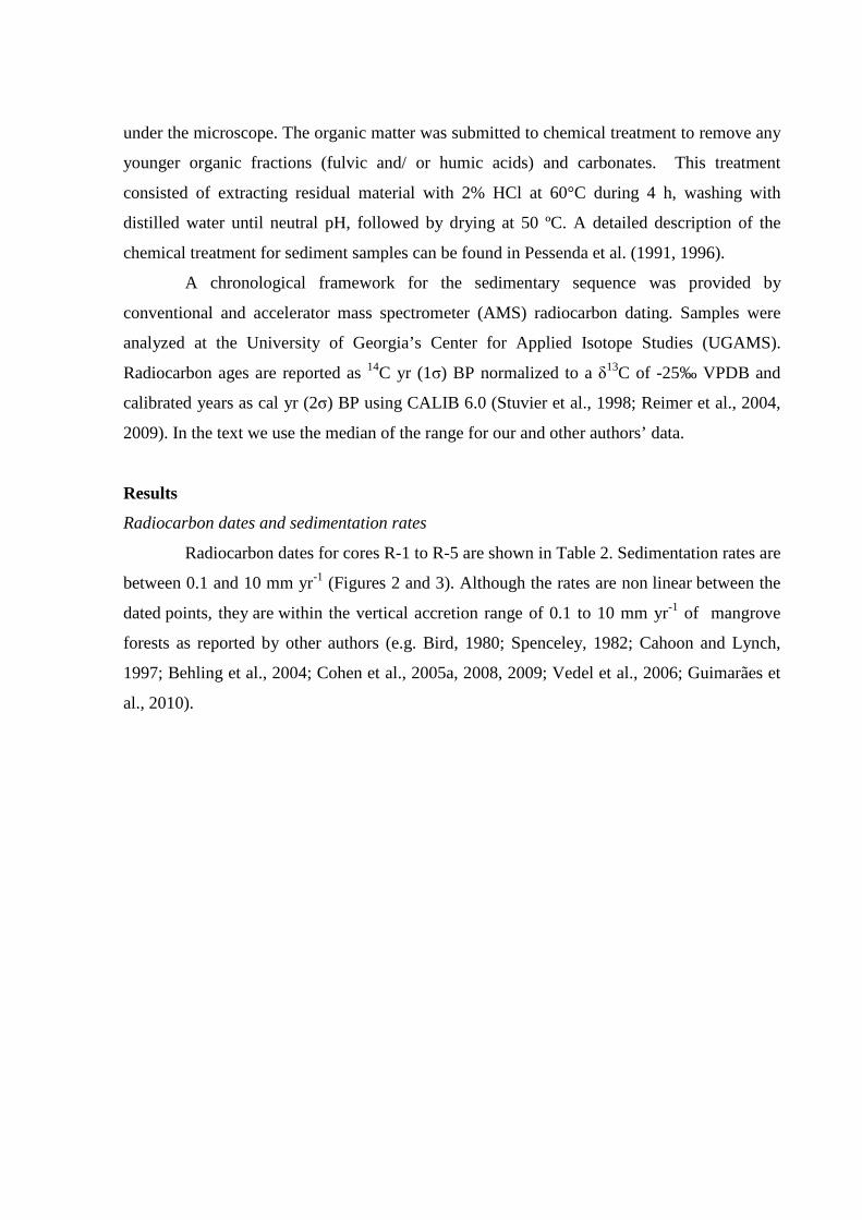
Figure 2 – Sediment profile with sedimentary features and ecological groups from cores R-1, R-2 and R-3.
Figure 3 – Sediment profile with sedimentary feature and ecological groups from cores R-4 and R-5.
Figure 4 – Pollen record from core R-1 with percentages of the most frequent pollen taxa and sample age.
Figure 5 – Pollen record from core R-2 with percentages of the most frequent pollen taxa and sample age.
Figure 6 – Pollen record from core R-3 with percentages of the most frequent pollen taxa and sample age.
Figure 7 – Pollen record from core R-4 with percentages of the most frequent
pollen taxa and sample age.
Figure 8 – Pollen record from core R-5 with percentages of the most frequent pollen taxa and sample age.
3 CHAPTER III: AN INTER-PROXY APPROACH TO ASSESSING THE DEVELOPMENT OF THE AMAZONIAN MANGROVE, DURING THE HOLOCENE
Figure 1 – Location of the study area: a) Sea water salinity, Amazon River plume and North Brazil Current (Santos et al., 2008); b) Marajó Island, which covers approximately 39,000 km2; c) Sampling in the mangrove; d) Sampling in the Lake São Luis; e) Mangrove and sand plain; f) Mangrove.
Figure 2 – Summary results for R-1 core: variation as a function of core depth from chronological, lithological profile, pollen analysis and geochemical variables.
Figure 3 – Summary results for R-2 core: variation as a function of core depth from chronological, lithological profile, pollen analysis and geochemical variables.
Figure 4 – Summary results for R-3 core: variation as a function of core depth from chronological, lithological profile, pollen analysis and geochemical variables.
Figure 5 – Summary results for R-4 core: variation as a function of core depth from chronological, lithological profile, pollen analysis and geochemical variables.
Figure 6 – Summary results for R-5 core: variation as a function of core depth from chronological, lithological profile, pollen analysis and geochemical variables.
Figure 7 – Binary diagram between δ13C x C/N for the different studies cores and different zones: a) R-1; b) R-2; c) R-3; d) R-4 and e) R-5 core. 7f) It represents the integration of δ13C and C/N data of organic matter preserved along the facies association Mangrove tidal flat. The different fields in the δ13C x C/N plots correspond to the member sources for organic matter preserved in sediments and trendline, on red line (modified from Meyers, 1997 and Lamb et al., 2006).
Figure 8 – Schematic representation of successive phases of sediment accumulation and vegetation change in the study area according to marine-freshwater influence gradient.
4 CHAPTER IV: LANDSCAPE EVOLUTION DURING THE LATE QUATERNARY AT THE DOCE RIVER MOUTH, ESPÍRITO SANTO STATE, SOUTHEASTERN BRAZIL
Figure 1 – a) Location of the study area, and its geological context. b) SRTM-DEM topography of the study site and lithostratigraphic profiles. C) Location of studied sediment cores and the spatial distribution of main geomorphological features.
Figure 2 – Topographic correlation among the facies associations identified in the studied cores.
Figure 3 – Stratigraphic description for Li01 with lithological profile, pollen analysis and geochemical variables.
Figure 4 – Stratigraphic description for Li24 with lithological profile, pollen analysis and geochemical variables.
Figure 5 – Diagram illustrating the relationship between δ13C and C/N for the different sedimentary facies, with interpretation according to data presented by Lamb et al. (2006) and Meyers (2003).
Figure 6 – Schematic representation of successive phases of sediment accumulation and vegetation change in the study area according to relative sea-level changes and sediment supply. ( cores location).
Figure 7 – Global sea-level curves to the late Quaternary.
5 CHAPTER V: MANGROVE VEGETATION CHANGES ON HOLOCENE TERRACES OF THE DOCE RIVER, SOUTHEASTERN BRAZIL
Figure 1 – Location of the study area: a) Miocene Barreiras Formation and coastal plain of the Doce River; b) RGB Landsat composition – SRTM, with a topographical profile obtained from SRTM digital elevation data illustrating a large area slightly more depressed on coastal plain of the Doce River; c) palaeodrainage networks preserved, with lagoons and lake system originated at the Holocene. Note the presence of Pleistocene deposits. Observe also, the beach ridges which are related to coastal progradation.
Figure 2 – Sharp contact between arboreal vegetation and herbaceous vegetation marking the red line the contact zone between paleolake and the edge at the coastal plain of the Doce River. The herbs and grasses are current vegetation which has been developed during since at least 3043 cal yr BP above of paleolake sediments.
Figure 3 – The X-ray of the core with examples of sedimentary facies of the tidal plain deposits, illustrating: a) massive mud (facies Mm); b) parallel laminated mud (facies Mp), with rootlets and root marks; c) parallel-laminated sand (facies Sp); d) heterolithic mud/sand deposit with plain remain (facies Hm); e) lenticular heterolithic muddy silt with cross lamination (facies Hl); f) sandy layer, heterolithic mud/sand deposit with convolute lamination and shells (facies Hf).
Figure 4 – Summary results for sediment core (LI-32): variation as a function of core depth showing chronological and lithological profile with sedimentary features and facies, pollen analysis with ecological groups,
organic geochemical variables and characteristics of organic matter influence. Pollen data are presented in pollen diagrams as percentages of the total pollen sum.
Figure 5 – Pollen diagram record with percentages of the most frequent pollen taxa, samples age, zones and cluster analysis.
Figure 6 – Diagram illustrating the relationship between δ13C and C/N ratio for the different sedimentary facies (foreshore, lagoon, lake and herbaceous plain), with interpretation according to data presented by Lamb et al. (2006); Meyers (2003) and Wilson et al. (2005) showing C4 plants with marine/brackish water influence and C3 plants with freshwater influence.
Figure 7 – Model of the geomorphology and vegetation development with successive phases of sediment accumulation according to relative sea-level changes during the Holocene.
Figure 8 – RSL curves of the eastern Brazilian coast during the Holocene with comparative pollen diagrams from northern and southeast Brazil coastline.
LISTA DE TABELAS
1 CHAPTER I: VEGETATION AND MORPHOLOGY CHANGES IN MOUTH OF THE AMAZON-PA AND DOCE RIVER-ES DURING THE LATE QUATERNARY
Table 1 – Sites, vegetation types, sampling method, coordinate and location.
Table 2 – Sediment cores with sampling site, depth, δ13C, 14C conventional and calibrated ages (using Calib 6.0; Reimer et al., 2009) from Marajó Island (Amazon region) and coastal plain of the Doce River (Southeastern Brazil).
2 CHAPTER II: THE LAST MANGROVES OF MARAJÓ ISLAND – EASTERN AMAZON: IIMPACT OF CLIMATE AND/OR RELATIVE SEA-LEVEL CHANGES
Table 1 – Study site, vegetation types, sampling method and geographic coordinates in the coast-al plain of Soure–eastern Marajó Island.
Table 2 – Sediment samples selected for Radiocarbon dating and results (R-1, R-2, R-3, R-4 and R-5).
Table 3 – Lithofacies description of cores R-1, R-2, R-3, R-4 and R-5, from the Soure coastal plain, eastern margin Marajó Island.
3 CHAPTER III: AN INTER-PROXY APPROACH TO ASSESSING THE DEVELOPMENT OF THE AMAZONIAN MANGROVE, DURING THE HOLOCENE
Table 1 – List of the current vegetation and their δ13C value.
Table 2 – Material, Depth, δ13C, 14C conventional and calibrated ages (using Calib 6.0; Reimer et al., 2009).
Table 3 – Summary of facies association, pollen, isotopes and C/N values, with the proposed interpretation of the depositional environments.
4 CHAPTER IV: LANDSCAPE EVOLUTION DURING THE LATE QUATERNARY AT THE DOCE RIVER MOUTH, STATE OF ESPÍRITO SANTO, SOUTHEASTERN BRAZIL
Table 1 – Radiocarbon dates of studied sediment cores.
5 CHAPTER V: MANGROVE VEGETATION CHANGES ON HOLOCENE TERRACES OF THE DOCE RIVER, SOUTHEASTERN BRAZIL
Table 1 – Sediment samples selected for Radiocarbon dating and results from LI-32 core (coastal plain of the Doce River) with material, depth, δ13C, 14C conventional and calibrated ages (using Calib 6.0; Reimer et al., 2009).
Table 2 – Summary of facies association with sedimentary characteristics, pollen groups and geochemical data.
SUMÁRIO
DEDICATÓRIA
AGRADECIMENTOS
RESUMO
ABSTRACT
LISTA DE ILUSTRAÇÕES
LISTA DE TABELAS
1 CHAPTER I: VEGETATION AND MORPHOLOGY CHANGES IN MOUTH OF THE AMAZON-PA AND DOCE RIVER-ES DURING THE LATE QUATERNARY
Introduction
Study area
Geological Setting
Marajó island – northern brazil
Coastal plain of the doce river – southeastern brazil
Climate
Vegetation
Materials and methods
Fields work and sample processing
Palynological analysis
δ13C, δ15N and C/N
Radiocarbon dating
Results and discussions
Marajó Island – Northern Brazil
Geomorphology changes in the coastal plain of the Doce River during the
late Pleistocene and Holocene
Mangrove vegetation changes during the Holocene
Conclusions
2 CHAPTER II: THE LAST MANGROVES OF MARAJÓ ISLAND – EASTERN AMAZON: IMPACT OF CLIMATE AND/OR RELATIVE SEA-LEVEL CHANGES * Paper published on Review of Palaeobotany and Palynology 187 (2012) 50-65 http://www.sciencedirect.com/science/article/pii/S0034666712002205
Abstract

Introduction
Study area
Present climate and vegetation
Materials and methods
Field work and sample processing
Pollen and spore analyses
Radiocarbon dating
Results
Radiocarbon dates and sedimentation rates
Facies description and pollen association
Mangrove/herbaceous flat facies association
Mangrove flat facies association
Lagoon facies association
Foreshore facies association
Lake facies association
Discussion
Pollen signal and vegetation changes in Marajó Island during the
Holocene (central and eastern coastal zone)
Mangrove dynamics during the last decades in the eastern coastal zone of
Marajó Island
Conclusions
3 CHAPTER III: AN INTER-PROXY APPROACH TO ASSESSING THE DEVELOPMENT OF THE AMAZONIAN MANGROVE, DURING THE HOLOCENE * Paper accepted on Vegetation History and Archaeobotany
Abstract
Introduction
Study site
Geological and geomorphological setting
Regional climate and oceanographic characteristics
Modern vegetation
Materials and methods
Sampling
Facies analysis
Pollen analysis
Organic geochemistry
Radiocarbon dating
Results
Radiocarbon dates and sedimentation rates
δ13C values of modern vegetation
Facies, pollen description and isotope values of the sediment cores
R-1 core (mangrove/várzea, 150 cm)
R-2 core (mangrove, 150 cm)
R-3 core (herbaceous plain/mangrove, 150 cm)
R-4 core (mangrove, 225 cm)
R-5 core (lake/herbaceous plain, 256 cm)
Interpretation and discussion
First phase (Early- to mid-Holocene – mangrove): ~7500 to ~3200 cal yr
BP
Second phase (Mid- to late-Holocene. – lake): ~3200 to ~1880 cal yr BP
Third phase (Late Holocene to modern – mangrove): ~1700 cal yr BP to
modern
Amazon River and Relative Sea Level (RSL) controlling mangrove
dynamics
Conclusions
4 CHAPTER IV: LANDSCAPE EVOLUTION DURING THE LATE QUATERNARY AT THE DOCE RIVER MOUTH, ESPÍRITO SANTO STATE, SOUTHEASTERN BRAZIL * Paper accepted on Palaeogeography, Palaeoclimatology, Palaeoecology
Abstract
Introduction
Study area
Location
Geology and geomorphology
Climate
Vegetation
Methods
Remote sensing
Sampling processing and facies description
Pollen and spore analysis
Isotopic and chemical analysis
Radiocarbon dating
Results
Radiocarbon dates and sedimentation rates
Facies description
Delta plain and Estuary central basin/lagoon-bay (A)
Facies Association A1- Beach ridge complex
Facies Association A2- Lake
Facies Association A3-Fluvial channel
Facies Association A4-Tidal channel
Facies Association A5- Marshes
Facies Association A6- Estuary central basin/lagoon-bay
Deltaic system (B)
Facies Association B1-Delta Plain
Facies Association B2-Delta Front
Facies Association B3-Prodelta
Palaeoenvironmental Interpretation
Climate and sea-level changes during the late Quaternary
Sea-level changes and fluvial sediment supply
Conclusion
5 CHAPTER V: MANGROVE VEGETATION CHANGES ON HOLOCENE TERRACES OF THE DOCE RIVER, SOUTHEASTERN BRAZIL * Paper published on Catena 110 (2013) 59-69 http://www.sciencedirect.com/science/article/pii/S0341816213001501
Abstract
Introduction
Modern settings
Study area and geological setting
Climate
Vegetation
Materials and methods
Field work and sampling processing
Facies description
Palynological analysis
Isotopic and chemical analysis
Radiocarbon dating
Results
Radiocarbon date and sedimentation rates
Facies, pollen description and isotopes values from sediment core
Facies association A (foreshore)
Facies association B (lagoon)
Facies association C (lake)
Facies association D (herbaceous plain)
Interpretation and discussion
Early Holocene: foreshore to lagoon
Middle-Late Holocene: Lagoon/lake transition to herbaceous flat
Holocene sea-level changes, climate and vegetation dynamics
Conclusion
REFERENCES
CHAPTER I:
VEGETATION AND MORPHOLOGY CHANGES IN MOUTH
OF THE AMAZON-PA AND DOCE-ES RIVER DURING THE
LATE QUATERNARY
Introduction
Climate change and Atlantic sea-level oscillation have produced an impact on
sedimentary dynamics and displacements of coastal ecosystems along the Brazilian littoral
during the late Quaternary (Suguio et al., 1985; Dominguez et al., 1992; Ledru et al., 1996;
Angulo and Lessa, 1997; Behling et al., 1998; Grimm et al., 2001; Bezerra et al., 2003; Martin
et al., 2003; Cohen et al., 2005a,b; Angulo et al., 2006; Vedel et al., 2006; Behling et al.,
2007; Sawakuchi et al., 2008; Lara and Cohen, 2009; Zular et al., 2013, Guimarães et al.,
2012, 2013; Buso Junior et al., 2013 – in press; França et al., 2012; 2013a,b – in press). The
region is largely controlled by complex interactions involving gradients of tidal oscillation,
river discharge, littoral currents, sediment and nutrient supply and winds (Dominguez, 2006;
Schaeffer-Novelli et al., 2000; Cohen et al., 2005a,b; Amaral et al., 2006; Cohen et al., 2009;
Dillenburg et al., 2009; Sanders et al., 2010, 2012; Pessenda et al., 2012; Smith et al., 2012;
Guimarães et al., 2012).
Regarding the mangroves, they occur broadly on the Brazilian coast (Schaeffer-
Novelli et al., 2000), and they have reacted clearly to climate change and sea-level
fluctuations, as they respond to environmental factors such as water salinity, nutrients and
input of sediment and freshwater (Krauss et al., 2008; Stevens et al., 2006; Stuart et al., 2007).
The evolutionary development of these forests is controlled by land-ocean interaction, and
their expansion is determined by topography, sediment geochemistry (Alongi, 2002), as well
as current energy conditions (Woodroffe, 1982). This ecosystem is highly adaptive, with
plants tolerant of extreme environmental conditions such as high salinity, anoxia and constant
water inundation (Vannucci, 2001). This adaptability has allowed mangroves to withstand
environmental change throughout the Holocene (Monacci et al., 2009), and become a marker
of great importance for scientific analysis of coastal change (Blasco et al., 1996).
The mangroves in the northern Brazilian littoral were present along the current
coastline since the early Holocene (Behling, 2001; Cohen et al., 2005a,b; 2012; Smith et al.,
2011; França et al., 2012). This ecosystem expanded along the coastal plain of the Doce River
during the early-middle Holocene (Buso Junior et al., 2013 – in press; França et al., 2013a –
in press). Currently the mangroves have presented a limited distribution in the northern
Brazilian littoral influenced by Amazon River and along the southeastern Brazilian coastline
(Amaral et al., 2006; Cohen et al., 2012; Pessenda et al., 2012).
Previous studies of pollen, biogeochemistry and sedimentary records along the
Brazilian coast have demonstrated that proxy analysis can provide important information
about coastal vegetation history (e.g. Grindrod et al., 2002; Amaral et al., 2006; Pessenda et
al., 2008; Cohen et al., 2009; Smith et al., 2011; França et al., 2012; Guimarães et al., 2012;
França et al., 2013b – in press). In this context, the goal of this study was to compare the
impact of sea-level fluctuations, and sediment/freshwater supply changes in mangrove areas
and morphological dynamics influenced by Amazon and Doce River during the late
Quaternary. This was carried out by the integration of multi-proxy data, including pollen,
sedimentary features, δ13C, δ15N, C/N and radiocarbon-date from twelve cores sampled along
the northern (Chapters II and III) and southeastern Brazilian coast (Chapters IV and V).
Study area
The study sites are located on Marajó Island (northern Brazil), at the mouth of the
Amazon River, and in the coastal plain of the Doce River (southeastern Brazil) (Figure 1).
Currently, the Marajó Island’s coastal vegetation is dominated by a regime of semidiurnal
meso- and macro-tides (tidal range of 2 to 4 m and 4 to 6 m, respectively) with variations
during the spring tide between 3.6 and 4.7 m (DHN, 2003), and influenced by Amazon River
discharge of approx. 170,000 m3 s-1 (ANA, 2003). Consequently, the river discharge and
hydrodynamic conditions allow a strong reduction of tidal water salinity along the adjacent
coast (Vinzon et al., 2008; Rosario et al., 2009) with salinity values between 7 and 30‰.
The second area located on the southeastern Brazilian littoral, State of Espírito Santo,
is between Conceição da Barra and Barra do Riacho. The coastal plain of the Doce River has
a maximum width of about 40 km and length of about 150 km (Suguio et al., 1982;
Bittencourt et al., 2007). This coastal region is influenced by the Atlantic ocean with
semidiurnal micro-tides (tidal range < 2 m), tidal water salinity between 9 and 34‰ and two
main rivers, the Doce River, with maximum and minimum outflow of 1900 and 400 m3 s-1,
and the São Mateus River with discharge about 11 m3 s-1 (Bernini et al., 2006; Freitas et al.,
2010).
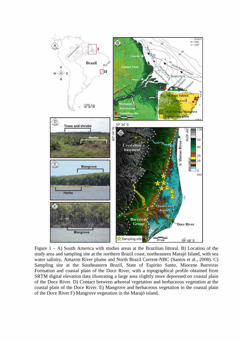
Figure 1 – A) South America with studies areas at the Brazilian littoral. B) Location of the study area and sampling site at the northern Brazil coast, northeastern Marajó Island, with sea water salinity, Amazon River plume and North Brazil Current-NBC (Santos et al., 2008). C) Sampling site at the Southeastern Brazil, State of Espirito Santo, Miocene Barreiras Formation and coastal plain of the Doce River, with a topographical profile obtained from SRTM digital elevation data illustrating a large area slightly more depressed on coastal plain of the Doce River. D) Contact between arboreal vegetation and herbaceous vegetation at the coastal plain of the Doce River. E) Mangrove and herbaceous vegetation in the coastal plain of the Doce River F) Mangrove vegetation in the Marajó island.
Geological Setting
Marajó Island – Northern Brazil
The coastal plain of Soure is located on the Pará platform of northern Brazil. It
pertains to a large area of crystalline and Palaeozoic sedimentary basement that remained
tectonically stable relative to adjacent Cretaceous and Cenozoic sedimentary basins (Rossetti
et al., 2008). The coastal plateau of northern Brazil is formed by the Barreiras Formation.
These deposits occur from northern to southeastern Brazil and are of Miocene age (Arai,
1997).
Except for a narrow belt where the Barreiras Formation occurs, the eastern portion of
the island is characterized by lowlands with altitudes averaging 4-6 m above the modern sea-
level (Rossetti et al., 2007, 2008) and is dominated by Holocene sedimentation, which is
topographically slightly lower than the western side (Behling et al., 2004; Rossetti et al.,
2007; Lara and Cohen, 2009). Along the eastern portion, the Barreiras Formation is
represented by sandstones and mudstones followed by post-Barreiras deposits (Rossetti et al.,
2008).
Marajó Island has a river system consisting of numerous small, straight and
meandering channels and ponds that are either permanent or ephemeral (Bemerguy, 1981).
The flat surface of the eastern part of the island has been deeply incised by a drainage system
during the Pleistocene and Holocene.
Coastal plain of the Doce River – Southeastern Brazil
The study site is located in the coastal plain between two large rivers, Doce and São
Mateus, northern Espírito Santo – Brazil, running along a nearly N-S section between
Conceição da Barra and Barra do Riacho (Suguio et al., 1982; Bittencourt et al., 2007). The
Holocene sedimentary history in this sector is strongly controlled by RSL changes, fluvial
supply and longshore transport. The formation of a barrier island/lagoonal system began about
7000 yr BP (Suguio et al., 1982; Martin et al., 1996; Martin et al., 2003).
The study area is composed of a Miocene age plateau of Barreiras Formation
continental deposits, whose surface is slightly sloping to the ocean. The site is characterized
by the presence of many wide valleys with flat bottoms, resulting from Quaternary deposition
of silty sediments (Martin et al., 1996). The study area is part of a larger area of tectonically
stable Precambrian crystalline rocks. Four geomorphological units are recognized in the area:
(1) a mountainous province, made up of Precambrian rocks, with a multidirectional
rectangular dendritic drainage net; (2) a tableland area composed of Barreiras Formation
constituted by sandstones, conglomerates and mudstones attributed mainly to Neogene fluvial
and alluvial fan deposits, but possibly including deposits originating from a coastal overlap
associated with Neogene marine transgressions (Arai, 2006; Dominguez et al., 2009). The
drainage catchment slopes gently down towards the sea; and (3) a coastal plain area, with
fluvial, transitional and shallow marine sediments, which were deposited during RSL changes
(Martin et al., 1987) and (4) an inner continental shelf area (Asmus et al. 1971).
Climate
Climate along the northern coast of Brazil is tropical (warm and humid), with annual
precipitation averaging 2300 mm (Lima et al., 2005). The rainy season occurs between the
months of December and May, with a drier period between June and November. Average
temperatures range between 25º and 29º C (Marengo et al., 1993, 2001; Nobre and Shukla,
1996; Fu et al., 2001; Liebmann and Marengo, 2001). Southeastern Brazil is characterized by
a warm and humid tropical climate with annual precipitation averaging 1400 mm (Peixoto and
Gentry, 1990). Precipitation generally occurs in the summer with a dry fall-winter season. The
rainy season occurs between the months of November and January with a drier period
between May and September. The average temperature ranges between 20º and 26º C
(Carvalho et al., 2004).
Vegetation
Modern vegetation on Marajó Island consists of herbaceous flats, natural open areas
that are dominated by Cyperaceae and Poaceae, “várzea” vegetation (swampland seasonally
and permanently inundated by freshwater) is composed of wetlands trees such as Euterpe
oleraceae and Hevea guianensis, while the “terra firme” vegetation, represented by the
Amazon Coastal Forest (ACF) unit, is characterized by Cedrela odorata, Hymenaea courbaril
and Manilkara huberi (Behling et at., 2004; Cohen et al., 2008; Smith et al., 2011, 2012).
“Restinga” (shrub and herb vegetation that occurs on sand plains and on dunes close to the
shore line) is dominated by Anacardiaceae and Malpighiaceae. Mangroves (tree heights
reaching ~20 m) are classified as Rhizophora sp. dominated with a presence of Avicennia sp.
and Laguncularia sp. (Cohen et al., 2008).
The coastal plain of the Doce River is characterized by forest pioneering freshwater
species such as Hypolytrum sp., Panicum sp and also brackish/marine water species such as
Polygala cyparissias, Remiria maritima, Typha sp., Cyperus sp., Montrichardia sp., Tapirira
guianensis and Symphonia globulifera. Tropical rainforest type vegetation is also present in
this region, where the most representative plant families are Annonaceae, Fabaceae,
Myrtaceae, Sapotaceae, Bignoniaceae, Lauraceae, Hippocrateaceae, Euphorbiaceae, and
Apocynaceae (Peixoto and Gentry, 1990). The mangrove ecosystem is characterized by
Rhizophora sp., Laguncularia sp. and Avicennia sp., which are currently restricted to the
northern and southern littoral part of the coastal plain (Bernini et al., 2006).
Materials and methods
Fields work and sample processing
For this study twelve sediment cores were analysed from areas occupied by different
vegetation units (Table 1): “várzea” (R-1), mangroves (R-2 and R-4), mangrove and
herbaceous vegetation (R-3), lacustrine herbaceous plain (R-5), herbaceous plain (LI-01, LI-
23, LI-26, LI-31, LI-32 and LI-33) and mixture between forest and herbaceous plain (LI-24).
Three sediment cores were collected in northern Brazil (R-1, R-2 and R-3) using a Russian
sampler (Cohen, 2003) and two sediment cores were taken with a vibracorer using an
aluminium tube (R-4 and R-5). Considering the coastal plain of the Doce River, one sediment
core was sampled (LI-32) using a Russian sampler and to the others was used a percussion
drilling Robotic Key System (RKS), model COBRA MK1 (COBRA Directional Drilling Ltd.,
Darlington, U.K.).
The cores were X-rayed in order to identify sedimentary structures. Samples were
collected for grain size analysis in the Laboratory of Chemical Oceanography/UFPA. Grain
size was determined by laser diffraction using a Laser Particle Size SHIMADZU SALD 2101.
The sediment grain size distributions were determined following the methods of Wentworth
(1922) and the graphics were elaborated using the SYSGRAN software (Camargo, 1999),
with sand (2-0.0625 mm), silt (62.5-3.9 µm) and clay fractions (3.9-0.12 µm). Facies analysis
included descriptions of color (MunsellColor, 2009), lithology, texture and structure (Harper
1984; Walker, 1992). The sedimentary facies were codified according to Miall (1978).
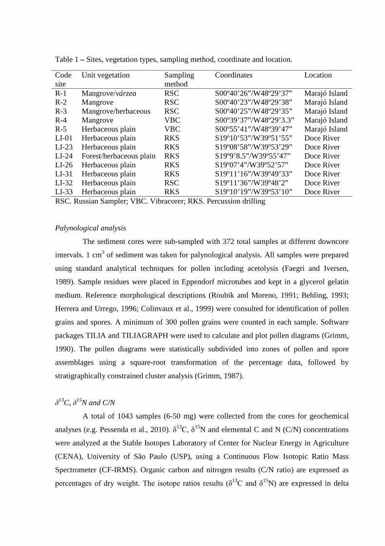
Table 1 – Sites, vegetation types, sampling method, coordinate and location.
Code site
Unit vegetation Sampling method
Coordinates Location
R-1 Mangrove/várzea RSC S00º40’26”/W48º29’37” Marajó Island R-2 Mangrove RSC S00º40’23”/W48º29’38” Marajó Island R-3 Mangrove/herbaceous RSC S00º40’25”/W48º29’35” Marajó Island R-4 Mangrove VBC S00º39’37”/W48º29’3.3” Marajó Island R-5 Herbaceous plain VBC S00º55’41”/W48º39’47” Marajó Island LI-01 Herbaceous plain RKS S19º10’53”/W39º51’55” Doce River LI-23 Herbaceous plain RKS S19º08’58”/W39º53’29” Doce River LI-24 Forest/herbaceous plain RKS S19º9’8.5”/W39º55’47” Doce River LI-26 Herbaceous plain RKS S19º07’4”/W39º52’57” Doce River LI-31 Herbaceous plain RKS S19º11’16”/W39º49’33” Doce River LI-32 Herbaceous plain RSC S19º11’36”/W39º48’2” Doce River LI-33 Herbaceous plain RKS S19º10’19”/W39º53’10” Doce River RSC. Russian Sampler; VBC. Vibracorer; RKS. Percussion drilling
Palynological analysis
The sediment cores were sub-sampled with 372 total samples at different downcore
intervals. 1 cm3 of sediment was taken for palynological analysis. All samples were prepared
using standard analytical techniques for pollen including acetolysis (Faegri and Iversen,
1989). Sample residues were placed in Eppendorf microtubes and kept in a glycerol gelatin
medium. Reference morphological descriptions (Roubik and Moreno, 1991; Behling, 1993;
Herrera and Urrego, 1996; Colinvaux et al., 1999) were consulted for identification of pollen
grains and spores. A minimum of 300 pollen grains were counted in each sample. Software
packages TILIA and TILIAGRAPH were used to calculate and plot pollen diagrams (Grimm,
1990). The pollen diagrams were statistically subdivided into zones of pollen and spore
assemblages using a square-root transformation of the percentage data, followed by
stratigraphically constrained cluster analysis (Grimm, 1987).
δ13C, δ15N and C/N
A total of 1043 samples (6-50 mg) were collected from the cores for geochemical
analyses (e.g. Pessenda et al., 2010). δ13C, δ15N and elemental C and N (C/N) concentrations
were analyzed at the Stable Isotopes Laboratory of Center for Nuclear Energy in Agriculture
(CENA), University of São Paulo (USP), using a Continuous Flow Isotopic Ratio Mass
Spectrometer (CF-IRMS). Organic carbon and nitrogen results (C/N ratio) are expressed as
percentages of dry weight. The isotope ratios results (δ13C and δ15N) are expressed in delta
per mil notation with an analytical precision greater than 0.2‰, with respect to the VPDB
standard and atmospheric air, respectively.
The relationship between δ13C, δ15N and C/N was used to provide information about
the origin of organic matter preserved in the coastal environment (Fry et al., 1977; Peterson
and Howarth, 1987; Schidlowski et al., 1983; Meyers, 1997, 2003; Wilson et al., 2005; Lamb
et al., 2006).
The δ13C values have different mean value between terrestrial plants, freshwater and
marine sources (Meyers, 1997). Some classes of plants also have different sources of CO2 (air
vs. water) or different carbon isotopic fractionations (C3 vs. C4 photosynthetic pathways).
Atmospheric nitrogen has a δ15N value of zero, and terrestrial plants tends to have δ15N values
close to 0‰, whereas Spartina sp. has δ15N values around +6‰, and near shore plankton have
values of around +6 to +10‰ (Wada 1980; Macko et al., 1984; Altabet and McCarthy, 1985).
Radiocarbon dating
Twenty nine bulk samples of ~10g each were used for radiocarbon dating (Table 2).
Samples were checked and physically cleaned (no roots) under the stereo microscope. The
residual material for each sample was then extracted with 2% HCl at 60°C for 4 hours,
washed with distilled water until neutral pH was reached, at 50 ºC and dried (Pessenda et al.,
2010, 2012). The organic matter from the sediment was analyzed by Accelerator Mass
Spectrometry (AMS) at the Center for Applied Isotope Studies (Athens, Georgia, USA) and
LACUFF (Fluminense Federal University). Radiocarbon ages are reported in years before AD
1950 (yr BP) normalized to δ13C of –25‰VPDB and in cal yr BP, 2σ (Reimer et al., 2009)
and use the median of the range for discussing our and other authors data in the text.
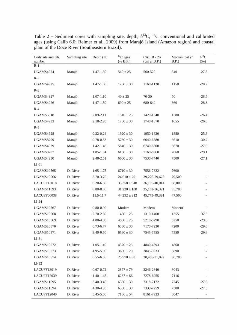
Table 2 – Sediment cores with sampling site, depth, δ13C, 14C conventional and calibrated ages (using Calib 6.0; Reimer et al., 2009) from Marajó Island (Amazon region) and coastal plain of the Doce River (Southeastern Brazil).
Cody site and lab. number
Sampling site Depth (m) 14C ages (yr B.P.)
CALIB - 2σ (cal yr B.P.)
Median (cal yr B.P.)
δ13C (‰)
R-1
UGAMS4924 Marajó 1.47-1.50 540 ± 25 560-520 540 -27.8
R-2
UGAMS4925 Marajó 1.47-1.50 1260 ± 30 1160-1120 1150 -28.2
R-3
UGAMS4927 Marajó 1.07-1.10 40 ± 25 70-30 50 -28.5
UGAMS4926 Marajó 1.47-1.50 690 ± 25 680-640 660 -28.8
R-4
UGAMS5318 Marajó 2.09-2.11 1510 ± 25 1420-1340 1380 -26.4
UGAMS4933 Marajó 2.18-2.20 1760 ± 30 1740-1570 1655 -26.6
R-5
UGAMS4928 Marajó 0.22-0.24 1920 ± 30 1950-1820 1880 -25.3
UGAMS8209 Marajó 0.78-0.83 5730 ± 30 6640-6580 6610 -30.2
UGAMS4929 Marajó 1.42-1.46 5840 ± 30 6740-6600 6670 -27.0
UGAMS8207 Marajó 1.85-1.94 6150 ± 30 7160-6960 7060 -29.1
UGAMS4930 Marajó 2.48-2.51 6600 ± 30 7530-7440 7500 -27.1
LI-01
UGAMS10565 D. River 1.65-1.75 6710 ± 30 7556-7622 7600 -
UGAMS10566 D. River 3.70-3.75 24,610 ± 70 29,226-29,678 29,500 -
LACUFF13018 D. River 6.20-6.30 33,358 ± 948 36,105-40,014 38,000 -
UGAMS11693 D. River 8.80-8.86 31,220 ± 100 35,162-36,321 35,700 -
LACUFF00038 D. River 11.5-11.7 44,232 ± 812 45,775-49,391 47,500 -
LI-24
UGAMS10567 D. River 0.80-0.90 Modern Modern Modern -
UGAMS10568 D. River 2.70-2.80 1480 ± 25 1310-1400 1355 -32.5
UGAMS10569 D. River 4.80-4.90 4500 ± 25 5210-5290 5250 -29.8
UGAMS10570 D. River 6.73-6.77 6330 ± 30 7170-7230 7200 -29.6
UGAMS10571 D. River 9.40-9.50 6560 ± 30 7545-7555 7550 -29.6
LI-31
UGAMS10572 D. River 1.05-1.10 4320 ± 25 4840-4893 4860 -
UGAMS10573 D. River 4.95-5.00 3600 ± 20 3845-3933 3890 -
UGAMS10574 D. River 6.55-6.65 25,970 ± 80 30,465-31,022 30,700 -
LI-32
LACUFF13019 D. River 0.67-0.72 2877 ± 79 3246-2840 3043 -
LACUFF12039 D. River 1.40-1.45 6237 ± 66 7278-6955 7116 -
UGAMS11695 D. River 3.40-3.45 6330 ± 30 7318-7172 7245 -27.6
UGAMS11694 D. River 4.30-4.35 6380 ± 30 7339-7259 7300 -27.5
LACUFF12040 D. River 5.45-5.50 7186 ± 54 8161-7933 8047 -
Results and discussions
Marajó Island – Northern Brazil
The cores from Marajó Island consist of dark gray and light brown muddy and sandy
silt sediments. Grain size increases towards the top of the core (see Chapter II). The δ13C
isotopic results exhibit values from –29.34‰ to –22.07‰ (mean= –26.55‰), which indicate
the dominance of C3 plants (–32‰ to –21‰; Deines, 1980; Boutton, 1996). The δ15N record
shows values between –0.61‰ and +6.04‰ (mean= +2.46‰), which suggests a mixture of
terrestrial plants (~0‰) and aquatic matter (+6 to +10‰) as observed by Wada (1980),
Macko et al. (1984) and Altabet and McCarthy (1985). The C/N values showed considerable
variation between 3.55 and 45.67 (mean= 22.04), which also indicate a mixture of organic
matter from vascular plants and algae (<10 algae dominance and >12 vascular plants; Meyers,
1994; Tyson, 1995) (França et al., 2013b – in press; see Chapter III).
The texture analysis and description of sedimentary structures of the materials
collected in the tidal flat, together with pollen records, grain size, isotopic (δ13C and δ15N) and
C/N values, allowed five facies associations to be defined: mangrove flat, lake, foreshore,
lagoon and mangrove/mixed flat on the eastern coast of the island during at least the last 7500
cal yr BP.
The results indicate a tidal mud flat colonized by mangroves with estuarine organic
matter between ~7500 and ~3200 cal yr BP. During the late Holocene this led to a gradual
migration of mangroves from the central region to the northeastern littoral zone of the island,
and, consequently, its isolation since at least ~1150 cal yr BP. This likely results from lower
tidal water salinity caused by a relatively wet period that resulted in greater river discharge
during the late Holocene. The northeastern area of the island exhibits relatively greater tidal
water salinity, due to the southeast-northwest trending littoral current which brings brackish
waters from more marine influenced areas. It has provided a refuge for the mangroves of
Marajó Island (França et al., 2012, see chapter II).
Over the last century, the increase in flow energy evidenced by upward mud/sand
transitions also contributes to mangrove retraction, as recorded in the upper part of core R-3
(see Chapter II). This is mainly due to landward sand migration, which covers the mudflat and
asphyxiates the mangrove. The increase in flow energy and exposure to tidal influence may
have been driven by the RSL rise, either associated with global fluctuations or tectonic
subsidence, and/or by the increase in river water discharge. These processes can modify the
size of the area occupied by mangroves (França et al., 2012; see chapter II).
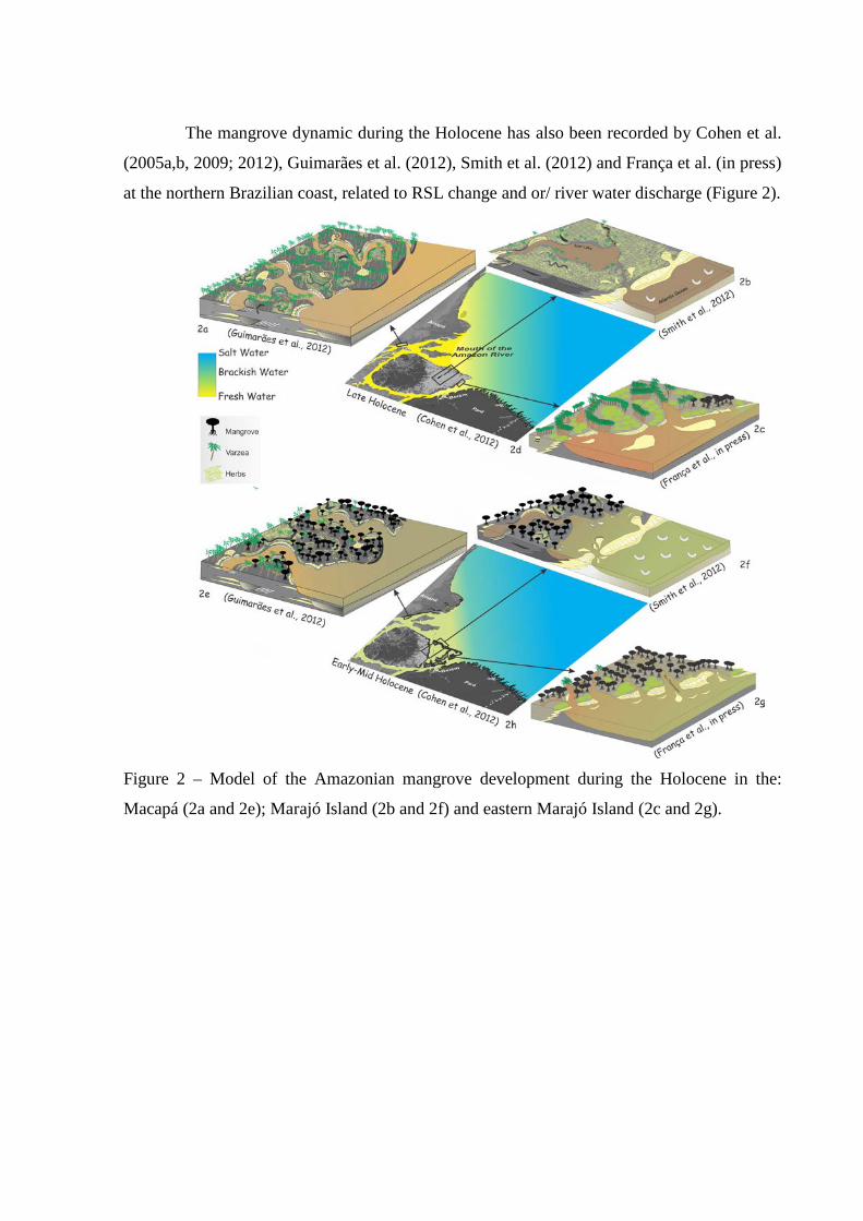
The mangrove dynamic during the Holocene has also been recorded by Cohen et al.
(2005a,b, 2009; 2012), Guimarães et al. (2012), Smith et al. (2012) and França et al. (in press)
at the northern Brazilian coast, related to RSL change and or/ river water discharge (Figure 2).
Figure 2 – Model of the Amazonian mangrove development during the Holocene in the:
Macapá (2a and 2e); Marajó Island (2b and 2f) and eastern Marajó Island (2c and 2g).
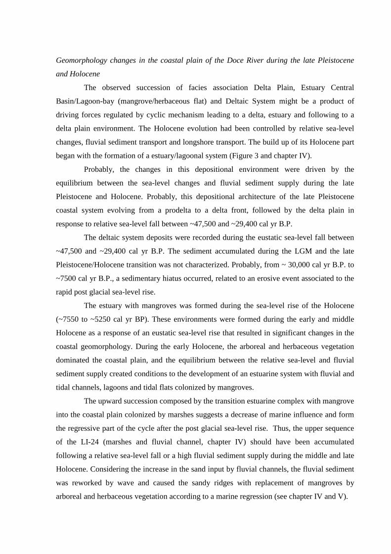
Geomorphology changes in the coastal plain of the Doce River during the late Pleistocene
and Holocene
The observed succession of facies association Delta Plain, Estuary Central
Basin/Lagoon-bay (mangrove/herbaceous flat) and Deltaic System might be a product of
driving forces regulated by cyclic mechanism leading to a delta, estuary and following to a
delta plain environment. The Holocene evolution had been controlled by relative sea-level
changes, fluvial sediment transport and longshore transport. The build up of its Holocene part
began with the formation of a estuary/lagoonal system (Figure 3 and chapter IV).
Probably, the changes in this depositional environment were driven by the
equilibrium between the sea-level changes and fluvial sediment supply during the late
Pleistocene and Holocene. Probably, this depositional architecture of the late Pleistocene
coastal system evolving from a prodelta to a delta front, followed by the delta plain in
response to relative sea-level fall between ~47,500 and ~29,400 cal yr B.P.
The deltaic system deposits were recorded during the eustatic sea-level fall between
~47,500 and ~29,400 cal yr B.P. The sediment accumulated during the LGM and the late
Pleistocene/Holocene transition was not characterized. Probably, from ~ 30,000 cal yr B.P. to
~7500 cal yr B.P., a sedimentary hiatus occurred, related to an erosive event associated to the
rapid post glacial sea-level rise.
The estuary with mangroves was formed during the sea-level rise of the Holocene
(~7550 to ~5250 cal yr BP). These environments were formed during the early and middle
Holocene as a response of an eustatic sea-level rise that resulted in significant changes in the
coastal geomorphology. During the early Holocene, the arboreal and herbaceous vegetation
dominated the coastal plain, and the equilibrium between the relative sea-level and fluvial
sediment supply created conditions to the development of an estuarine system with fluvial and
tidal channels, lagoons and tidal flats colonized by mangroves.
The upward succession composed by the transition estuarine complex with mangrove
into the coastal plain colonized by marshes suggests a decrease of marine influence and form
the regressive part of the cycle after the post glacial sea-level rise. Thus, the upper sequence
of the LI-24 (marshes and fluvial channel, chapter IV) should have been accumulated
following a relative sea-level fall or a high fluvial sediment supply during the middle and late
Holocene. Considering the increase in the sand input by fluvial channels, the fluvial sediment
was reworked by wave and caused the sandy ridges with replacement of mangroves by
arboreal and herbaceous vegetation according to a marine regression (see chapter IV and V).
32
Figure 3 – Model for coastal plain evolution of the Doce River during the late Pleitocene to Holocene.
33
Mangrove vegetation changes during the Holocene
During the Holocene, the post-glacial sea-level rise and changes in river water
discharge have been considered the main driving forces behind the expansion/contraction of
mangroves in northern Brazil (Cohen et al., 2008; Lara and Cohen, 2009; França et al., 2012;
Guimarães et al., 2012; Smith et al., 2012). The data from Marajó Island indicates a tidal mud
flat colonized by mangroves with an influence of estuarine organic matter and terrigenous
input between at least ~7500 and ~3200 cal yr BP (chapters II and III). This is likely due to
the relatively higher marine influence caused by post-glacial sea-level rise, and the dry period
experienced by the Amazon region during the early and middle Holocene (Pessenda et al.,
2001; Behling and Hooghiemstra, 2000; Freitas et al., 2001; Sifeddine et al. 2001; Weng et
al., 2002; Bush et al., 2007). As rainfall controls the volume of the Amazon River (Eisma et
al., 1991; Maslin and Burns, 2000; Latrubesse and Fanzinelli, 2002), lower precipitation
resulted in severely reduced freshwater discharge (Amarasekera et al., 1997; Toledo and
Bush, 2007, 2008). This led to a greater influence of saline marine water and mangrove
expansion in the northern Brazil (Cohen et al., 2012).
During the late Holocene occurred a decrease in mangrove vegetation area in the
Marajó Island. Likely it was caused by an increase in river discharge, which resulted in a
relatively low tidal water salinity during that time (França et al., 2012; see chapter II and III).
In contrast, the dynamics of these forests in southeastern Brazil have been controlled
mainly by sediment supply associated to sea-level fluctuations. The post-glacial sea-level rise
caused change in the coastal environment along southeastern Brazil (Giannini et al., 2007;
Guedes et al., 2011; Pessenda et al., 2012), which resulted in the formation of numerous
lagoons and estuarine systems around 7800 cal yr BP (Martin et al., 1996; Sallun et al., 2012)
colonized by mangrove and herbaceous vegetation (Buso Junior et al., in press). Sea-level
oscillations have apparently been more intense and recognizable in this region. During the
early and middle Holocene several studies on the Brazilian coastal zone indicate significant
climatic changes and RSL fluctuations (Suguio et al., 1985; Dominguez et al., 1992; Angulo
and Lessa, 1997; Bezerra et al., 2003; Martin et al., 2003; Cohen et al., 2005a,b; Angulo et al.,
2006; Vedel et al., 2006; Lara and Cohen, 2009). The Salvador sea-level curve (northeastern
Brazil), reconstructed by Martin et al. (2003) extends back to around 7800 cal yr BP, when
the mean sea level exceeded the current level for the first time in the Holocene. This period
coincided with a dryer period in the Amazonian hydrographic region (Van der Hammem,
1974; Absy et al., 1991; Desjardins et al., 1996; Behling and Costa, 2000; Ledru, 2001;
Pessenda et al., 2001). Between ~8050 and ~5200 cal yr BP, our data from coastal plain of the

Doce River indicate a predominance of muddy sediments supply and that C4 plants are
present, with greater influence from C3 plants and estuarine water. During the middle to late
Holocene, an increase in the contribution of sandy sediments and terrestrial organic matter
occurred with C4 plants influence (chapters IV and V), probably associated with a RSL fall,
resulting in a retraction of mangroves and expansion of herbaceous vegetation, trees and
shrubs.
During the late Holocene, there was a decrease in the extent of mangrove vegetation
in Marajó Island and in the coastal plain of the Doce River, mainly caused by increase of
freshwater discharge and sandy sediment supply associated to RSL fall, respectively.
Mangrove environments are now isolated in areas with some marine influence and suitable
mud sediment supply. Regarding the coastal plain of the Doce River, the data indicate that the
input of freshwater organic matter and terrigenous material during the late Holocene was
higher than the early and middle Holocene. This transition from marine to freshwater
influence, likely is due to the combined action of RSL fall and sedimentary supply during the
late Holocene. Furthermore, tectonic activities may have caused RSL changes in both studied
sectors with a potential impact on mangrove distribution (Rossetti et al., 2007; Miranda et al.,
2009; Rossetti et al., 2012).
Conclusions
The delta plain of the Doce River presents a stratigraphic sequence with development
of a deltaic system to estuarine and to continental terraces produced by the interplay of
relative sea-level changes and sediment river discharge. The regressive deposits reveal
highstand systems tracts and forced/normal regressive systems tracts in cycles developed
according to the rate of relative sea-level changes combined with local sediment supply.
Therefore, the equilibrium between the relative sea-level and fluvial sediment supply
allowed the development of a deltaic system in response mainly to sea-level fall during at
least ~47,500 and ~29,400 cal yr B.P (chapter IV). After the post-glacial sea-level rise, an
estuarine complex was developed with wide tidal mud flats occupied by mangroves during the
early and middle Holocene both in the mouth of the Amazon (chapter II and III) and Doce
River (chapter V).
Considering the Holocene vegetation history of northern Brazil, the data from
Marajó Island indicate a tidal mud flat colonized by mangroves with influence of estuarine
organic matter between at least ~7500 and ~3200 cal yr BP (chapter III). This is likely due to
the relatively higher marine influence and dryer conditions during this period. During the late

Holocene, there was a decrease in the extent of mangrove vegetation in Marajó Island and in
the coastal plain of the Doce River, mainly caused by increase of freshwater discharge and
sandy sediment supply associated to RSL fall, respectively. Mangrove environments are now
isolated in areas with some marine influence and suitable mud sediment supply. Regarding
the southeastern Brazil, the data indicate that the input of freshwater organic matter and
terrigenous material during the late Holocene was higher than the early and middle Holocene.
This transition from marine to freshwater influence, likely is due to the combined action of
RSL fall and sedimentary supply during the late Holocene. In the Marajó Island, during the
late Holocene, there was a return to more continental conditions, heavily influenced by
freshwater with mangroves isolated to a small area (100-700 m width) in the northeastern part
of the island (chapter III).
Over the last century, the increase in flow energy evidenced by upward mud/sand
transitions also contributes to mangrove retraction in the Marajó Island (see chapter II). This
is mainly due to landward sand migration, which covers the mudflat and asphyxiates the
mangrove. The increase in flow energy and exposure to tidal influence may have been driven
by the RSL rise, either associated with global fluctuations or tectonic subsidence, and/or by
the increase in river water discharge. These processes can modify the size of the area
occupied by mangroves (chapter II).
CHAPTER II:
THE LAST MANGROVES OF MARAJÓ ISLAND – EASTERN
AMAZON: IMPACT OF CLIMATE AND/OR RELATIVE
SEA-LEVEL CHANGES
* Paper published on Review of Palaeobotany and Palynology 187 (2012) 50-65 http://www.sciencedirect.com/science/article/pii/S0034666712002205
Abstract
The dynamics, over the last 7,500 years, of a mangrove at Marajó Island in northern
Brazil were studied by pollen and sedimentary facies analyses using sediment cores. This
island, located at the mouth of the Amazon River, is influenced by riverine inflow combined
with tidal fluctuations of the equatorial Atlantic Ocean. Herbaceous vegetation intermingled
with rainforest dominates the central area of the island, while várzea is the main vegetation
type along the littoral. In particular, the modern northeastern coastal zone is covered by a
mosaic of dense rainforest, herbaceous vegetation, mangroves, várzea , and restinga. The
integration of pollen data and facies descriptions indicates a tidal mud flat colonized by
mangroves in the interior of Marajó Island between ~ 7,500 cal yr BP and ~ 3,200 cal yr BP.
During the late Holocene, mangroves retracted to a small area (100-700 m in width) along the
northeastern coastal plain. Mangrove expansion during the early and mid Holocene was likely
caused by the post-glacial sea-level rise which, combined with tectonic subsidence, led to a
rise in tidal water salinity. Salinity must have further increased due to low river discharge
resulting from increased aridity during the early and mid Holocene. The shrinking of the area
covered by mangrove vegetation during the late Holocene was likely caused by the increase in
river discharge during the late Holocene, which has maintained relatively low tidal water
salinity in Marajó Island. Tidal water salinity is relatively higher in the northeastern part of
the island than in others, due to the southeast-northwest trending current along the littoral.
The mixing of marine and riverine freshwater inflows has provided a refuge for mangroves in
this area. The increase in flow energy during the last century is related to landward sand
migration, which explains the current retraction of mangroves. These changes may indicate an
increased exposure to tidal influence driven by the relative sea-level rise, either associated
with global fluctuations or tectonic subsidence, and/or by an increase in river water discharge.
Keywords: Amazon coast; climate; Holocene; palynology; sea level; vegetation
Introduction
Mangroves are highly susceptible to climatic changes and sea-level oscillations (e.g.,
Fromard et al., 2004; Versteegh et al., 2004; Alongi, 2008; Berger et al., 2008). They have
been almost continuously exposed to disturbance as a result of fluctuations in sea-level over
the last 11,000 years (Gornitz, 1991; Blasco et al., 1996; Sun and Li, 1999; Behling et al.,
2001; Lamb et al., 2006; Alongi, 2008; Berger et al., 2008; Cohen et al., 2008; Gilman et al.,
2008). During the Holocene, the post-glacial sea-level rise and changes in river water
discharge have been considered the main driving forces behind the expansion/contraction of
mangroves in northern Brazil (Cohen et al., 2008; Lara and Cohen, 2009; Guimarães et al.,
2010; Smith et al., 2012). However, important changes in coastal morphology have been
recorded in this region as a result of tectonic reactivations, which could have modified the
relative sea-level (RSL), with a potential impact on mangrove distribution (Rossetti et al.,
2007; Miranda et al., 2009; Rossetti et al., 2012).
An empirical model based on an ecohydrological approach, which allows the
integration of hydrographical, topographical and physicochemical information with vegetation
characteristics of mangroves and marshes, indicates that changes in pore water salinity affect
vegetation boundaries (Cohen and Lara, 2003; Lara and Cohen, 2006). In addition to studies
in northern Brazil, the relationship between mangrove distribution and sediment geochemistry
has been widely studied in other coastal regions (Hesse, 1961; Baltzer, 1970; Walsh, 1974;
Baltzer, 1975; Snedaker, 1982; Lacerda et al., 1995; McKee, 1995; Pezeshki et al., 1997;
Clark et al., 1998; Youssef and Saenger, 1999; Matthijs et al., 1999; Alongi et al., 1998, 1999,
2000).
Generally, mangroves are distributed parallel to the coast with some species
dominating areas more exposed to the sea, and others occurring landward at higher elevations
(Snedaker, 1982). This zonation is a response of mangrove species mainly to tidal inundation
frequency, nutrient availability, and porewater salinity in the intertidal zone (Hutchings and
Saenger, 1987).
Mangroves of the littoral of northern Brazil follow well-known patterns (Behling et
al., 2001; Cohen et al., 2005a), where salinity results in the exclusion of freshwater species
(Snedaker, 1978) and leads to characteristic patterns of species zonation and predictable types
of community structure (Menezes et al., 2003). Mangroves are more tolerant to soil salinity
than is várzea forest (Gonçalves-Alvim et al., 2001) and sediment salinity is mostly controlled
by flooding frequency (Cohen and Lara, 2003) and estuarine gradients (Lara and Cohen,
2006).
Changes in mangrove distribution may also reflect changes in variables that control
coastal geomorphology (e.g. Blasco et al., 1996; Fromard et al., 2004; Lara and Cohen, 2009).
The development of mangroves is regulated by continent-ocean interactions and their
expansion is determined by the topography relative to sea-level (Gornitz, 1991; Cohen and
Lara, 2003) and flow energy (Chapman, 1976; Woodroffe, 1989), where mangroves
preferentially occupy mud surfaces. Thus, a relative rise in sea-level may result in mangroves
migrating inland due to changes in flow energy and tidal inundation frequency. Similarly,
vegetation on elevated mudflats is subject to boundary adjustments, since mangroves can
migrate to higher locations and invade these areas (Cohen and Lara, 2003).
The potential of each variable to influence mangrove establishment will depend on
the environmental characteristics of the given littoral. Climate and hydrology are the main
factors controlling the modern distribution of geobotanical units along the coast of the
Amazon (Cohen et al., 2008, 2009). According to these authors, mangroves and saltmarshes
dominate the marine-influenced littoral when tidal water salinity lies between 30 and 7‰ to
the southeastern coastline, and várzea and herbaceous vegetation dominate freshwater-
influenced coasts with tidal water salinity below 7‰ in the northwest. The littoral of Marajó
Island, at the mouth of the Amazon River, is part of the fluvial sector (Figure 1a) (Cohen et
al., 2008; Smith et al., 2011, 2012).
The mangroves of Marajó Island are currently restricted to a relatively narrow
section of the northeastern area of the island (Cohen et al., 2008; Smith et al., 2012). This
mangrove has developed continuously since at least 2,700 cal yr BP (Behling et al., 2004).
According to pollen records from hinterland (Lake Arari), the area covered by mangrove
vegetation was wider between ~7,250 and ~2,300 cal yr BP (Smith et al., 2011).
The purpose of this work was to study the environmental history of the northeastern
part of Marajó Island, and discuss the processes that caused the contraction of the mangrove
during the Holocene. We focus on vegetation development, the location of boundaries
between mangrove and dry herbaceous vegetation, and areas where changes in sensitive
vegetation related to RSL and tidal water salinities can be expected. This approach is based on
the integration of pollen and facies analyses of five sediment cores, collected at distinct
locations presently covered by mangrove, várzea and herbaceous vegetation.
Study area
The study site is located on the island of Marajó in northern Brazil, which covers
approximately 39,000 km2 (Cohen et al., 2008). The island is located at the mouth of the
Amazon River (Figure 1). Sediment cores were taken on the coastal plain of the town of
Soure and from a lake surrounded by a herbaceous plain, and cores were denominated R-1, R-
2, R-3, R-4 and R-5 (Table 1).
The study area covers the central-eastern part of the coastal plain. Its topographical
range is less than 5 m and it extends inland to the maximum of the intertidal zone, which
borders the coastal plateau (França and Sousa Filho, 2006).
41
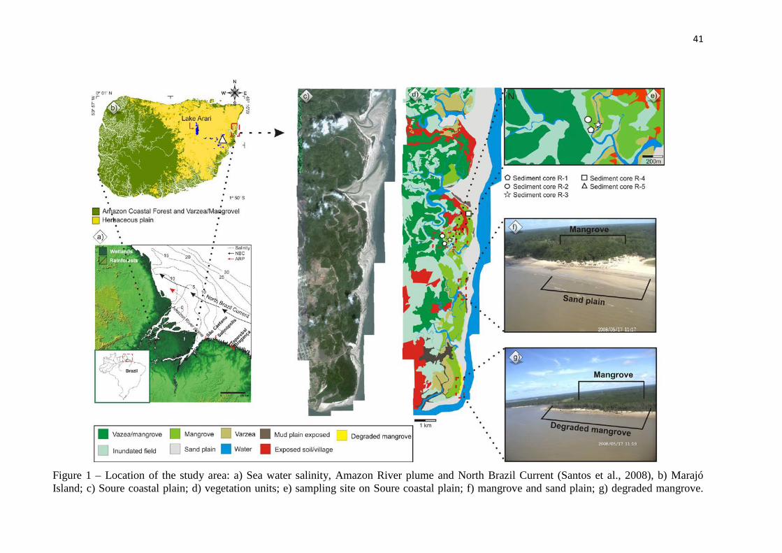
Figure 1 – Location of the study area: a) Sea water salinity, Amazon River plume and North Brazil Current (Santos et al., 2008), b) Marajó Island; c) Soure coastal plain; d) vegetation units; e) sampling site on Soure coastal plain; f) mangrove and sand plain; g) degraded mangrove.
42
Table 1 – Study site, vegetation types, sampling method and geographic coordinates in the coastal plain of Soure– eastern Marajó Island.
Cody site
Unit vegetation and main taxa Sampling method Coordinates
R-1
Mangrove/varzea transition – characterised by Rhizophora mangle and others taxa: Arecaceae (Euterpe oleracea; Mauritia flexuosa); Araceae (Montrichardia arborescens); Aizoaceae (Sesuvium); Acanthaceae (Avicennia germinans); Cyperaceae; Heliconiaceae; Musaceae; Myrtaceae (Psidium guajava); Poaceae (Olyra); Pteridaceae (Acrostichum auereum)
Russian Sampler
S 00º40’26.3 / W 048º29’37.2”
R-2 Mangrove – characterised by Rhizophora mangle
Russian Sampler S 00º40’23.1 / W 048º29’38.8”
R-3
Herbaceous and restinga vegetation – characterised by Arecaceae (Euterpe oleracea; Mauritia flexuosa); Birzonimia; Cyperaceae; Poaceae (Olyra); Malpiguiaceae
Russian Sampler
S 00º40’25.2” / W 48º29’35.7”
R-4 Mangrove – characterised by Rhizophora mangle
Vibracorer S 00º39’37” / W 048º29’3.3”
R-5 Herbaceous flat – characterised by Convovulaceae; Rubiaceae; Cyperaceae and Poaceae
Vibracorer S 00º55’41” / W 048º39’47”
Geological and geomorphological setting
The coastal plain of Soure is located on the Pará platform of northern Brazil. It
pertains to a large area of crystalline and Palaeozoic sedimentary basement that remained
tectonically stable relative to adjacent Cretaceous and Cenozoic sedimentary basins (Rossetti
et al., 2008). The coastal plateau of northern Brazil is formed by the Barreiras Formation.
These deposits occur from northern to southeastern Brazil and are of Miocene age (Arai,
1997).
Except for a narrow belt where the Barreiras Formation occurs, the eastern portion of
the island is characterized by lowlands with altitudes averaging 4-6 m above the modern sea-
level (Rossetti et al., 2007, 2008) and is dominated by Holocene sedimentation (Behling et al.,
2004), which is topographically slightly lower than the western side (Behling et al., 2004;
Rossetti et al., 2007; Lara and Cohen, 2009). Along the eastern portion, the Barreiras
Formation is represented by sandstones and mudstones followed by post-Barreiras deposits
(Rossetti et al., 2008).
Marajó Island has a river system consisting of numerous small, straight and
meandering channels and ponds that are either permanent or ephemeral (Bemerguy, 1981).
The flat surface of the eastern part of the island has been deeply incised by a drainage system
during the Pleistocene and Holocene.
Present climate and vegetation
The region is characterized by a warm and humid tropical climate with annual
precipitation averaging 2,300 mm (Lima et al., 2005). The rainy season extends between
December and May, with average temperatures ranging between 25 and 29ºC. The region is
dominated by a regime of meso- and macrotides (tidal range of 2 to 4 m and 4 to 6 m,
respectively) with variation during the spring tide between 3.6 and 4.7 m (DHN, 2003).
In contrast to most regions of Amazonia, where dense forest dominates, northeastern
Marajó Island is covered with open vegetation. Restinga vegetation is represented by shrubs
and herbs (e.g., Anacardium, Byrsonima, Annona, Acacia) that occur on sand plains and
dunes near the shoreline. Mangrove is represented by Rhizophora and Avicennia (tree heights
reaching ~20 m). The herbaceous plain consists of naturally open areas dominated by
Cyperaceae and Poaceae that widely colonize the eastern side of Marajó Island. Várzea
(swamp seasonally and permanently inundated by freshwater, featuring wetland trees such as
Euterpe oleracea and Hevea guianensis) and Amazon coastal forest (ACF) (composed of
terrestrial trees such as Cedrela odorata, Hymenaea courbaril and Manilkara huberi) occur
on the western side (Cohen et al., 2008). Narrow and elongated belts of dense ombrophilous
forest are also present along riverbanks (Rossetti et al., 2008). Detailed information on the
most characteristic taxa of each vegetation unit is found in Smith et al. (2011).
Materials and methods
Field work and sample processing
LANDSAT images acquired in 2010 were obtained from INPE (National Space
Research Institute, Brazil). A three-color band composition (RGB 543) image was created and
processed using the SPRING 3.6.03 system to discriminate geobotanical units (Cohen and
Lara, 2003). Aerial photography, visual observation, photographic documentation, and GPS
measurements were used to determine typical plant species and characterize the main
vegetation units.
Three sediment cores (R-1, R-2 and R-3) were collected during the summer season
(Nov. 2008), using a Russian sampler (Cohen, 2003), and two other cores were taken with a
vibracorer using aluminum tubes (R-4 and R-5). Cores were taken from an area occupied by
different vegetation units: mangroves (R4 and R2), várzea (R-1), mangrove and herbaceous
vegetation (R-3), and a lacustrine herbaceous plain (R-5) (Table 1).
The cores were submitted to X-ray to identify sedimentary structures. Samples were
collected for grain size analysis at the Chemical Oceanography Laboratory of the Federal
University of Pará (UFPA). This analysis made use of a laser particle size analyzer
(SHIMADZU SALD 2101), and graphics were obtained using the Sysgran Program
(Camargo, 1999). Grain size distribution followed Wentworth (1922), with separation of sand
(2 - 0.0625 mm), silt (62.5-3.9 µm) and clay (3.9-0.12 µm) fractions. Facies analysis included
descriptions of color (Munsell Color, 2009), lithology, texture and structure (Harper, 1984;
Walker, 1992). The sedimentary facies were codified according to Miall (1978).
Pollen and spore analyses
For pollen analysis, 1 cm3 samples were taken at 2.5 cm intervals along sediment
cores R-1, R-2 and R-3 (each 150 cm deep). From sediment cores R-4 and R-5, 24 and 36
samples were collected, respectively. Prior to processing, one tablet of exotic Lycopodium
spores was added to each sediment sample to allow the calculation of pollen concentration
(grains cm-3) and pollen influx rates (grains cm-2 yr-1). All samples were prepared using
standard analytical techniques for pollen including acetolysis (Faegri and Iversen, 1989).
Sample residues were placed in Eppendorf microtubes and kept in a glycerol gelatin medium.
Reference morphological descriptions (Roubik and Moreno, 1991; Behling, 1993;
Herrera and Urrego, 1996) were consulted for identification of pollen grains and spores. A
minimum of 300 pollen grains were counted in each sample. The pollen sum excludes fern
spores, algae and micro-foraminifers. Pollen and spore data are presented in diagrams as
percentages of the pollen sum. Taxa were grouped into mangrove, herbaceous plain elements,
restinga, palms, and Amazon coastal forest. Software packages TILIA and TILIAGRAF were
used to calculate and plot pollen diagrams. The pollen diagrams were statistically subdivided
into zones of pollen and spore assemblages using a square-root transformation of the
percentage data, followed by stratigraphically constrained cluster analysis (Grimm, 1987).
Radiocarbon dating
Based on stratigraphic discontinuities suggesting changes in the tidal inundation
regime, fourteen bulk samples (10 g each) were selected. In order to avoid natural
contamination (e.g. Goh, 2006), the sediment samples were checked and physically cleaned
under the microscope. The organic matter was submitted to chemical treatment to remove any
younger organic fractions (fulvic and/ or humic acids) and carbonates. This treatment
consisted of extracting residual material with 2% HCl at 60°C during 4 h, washing with
distilled water until neutral pH, followed by drying at 50 ºC. A detailed description of the
chemical treatment for sediment samples can be found in Pessenda et al. (1991, 1996).
A chronological framework for the sedimentary sequence was provided by
conventional and accelerator mass spectrometer (AMS) radiocarbon dating. Samples were
analyzed at the University of Georgia’s Center for Applied Isotope Studies (UGAMS).
Radiocarbon ages are reported as 14C yr (1σ) BP normalized to a δ13C of -25‰ VPDB and
calibrated years as cal yr (2σ) BP using CALIB 6.0 (Stuvier et al., 1998; Reimer et al., 2004,
2009). In the text we use the median of the range for our and other authors’ data.
Results
Radiocarbon dates and sedimentation rates
Radiocarbon dates for cores R-1 to R-5 are shown in Table 2. Sedimentation rates are
between 0.1 and 10 mm yr-1 (Figures 2 and 3). Although the rates are non linear between the
dated points, they are within the vertical accretion range of 0.1 to 10 mm yr-1 of mangrove
forests as reported by other authors (e.g. Bird, 1980; Spenceley, 1982; Cahoon and Lynch,
1997; Behling et al., 2004; Cohen et al., 2005a, 2008, 2009; Vedel et al., 2006; Guimarães et
al., 2010).
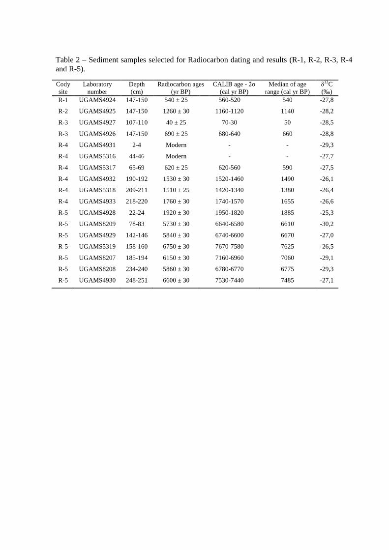
Table 2 – Sediment samples selected for Radiocarbon dating and results (R-1, R-2, R-3, R-4 and R-5).
Cody site
Laboratory number
Depth (cm)
Radiocarbon ages (yr BP)
CALIB age - 2σ (cal yr BP)
Median of age range (cal yr BP)
δ13C (‰)
R-1 UGAMS4924 147-150 540 ± 25 560-520 540 -27,8
R-2 UGAMS4925 147-150 1260 ± 30 1160-1120 1140 -28,2
R-3 UGAMS4927 107-110 40 ± 25 70-30 50 -28,5
R-3 UGAMS4926 147-150 690 ± 25 680-640 660 -28,8
R-4 UGAMS4931 2-4 Modern - - -29,3
R-4 UGAMS5316 44-46 Modern - - -27,7
R-4 UGAMS5317 65-69 620 ± 25 620-560 590 -27,5
R-4 UGAMS4932 190-192 1530 ± 30 1520-1460 1490 -26,1
R-4 UGAMS5318 209-211 1510 ± 25 1420-1340 1380 -26,4
R-4 UGAMS4933 218-220 1760 ± 30 1740-1570 1655 -26,6
R-5 UGAMS4928 22-24 1920 ± 30 1950-1820 1885 -25,3
R-5 UGAMS8209 78-83 5730 ± 30 6640-6580 6610 -30,2
R-5 UGAMS4929 142-146 5840 ± 30 6740-6600 6670 -27,0
R-5 UGAMS5319 158-160 6750 ± 30 7670-7580 7625 -26,5
R-5 UGAMS8207 185-194 6150 ± 30 7160-6960 7060 -29,1
R-5 UGAMS8208 234-240 5860 ± 30 6780-6770 6775 -29,3
R-5 UGAMS4930 248-251 6600 ± 30 7530-7440 7485 -27,1
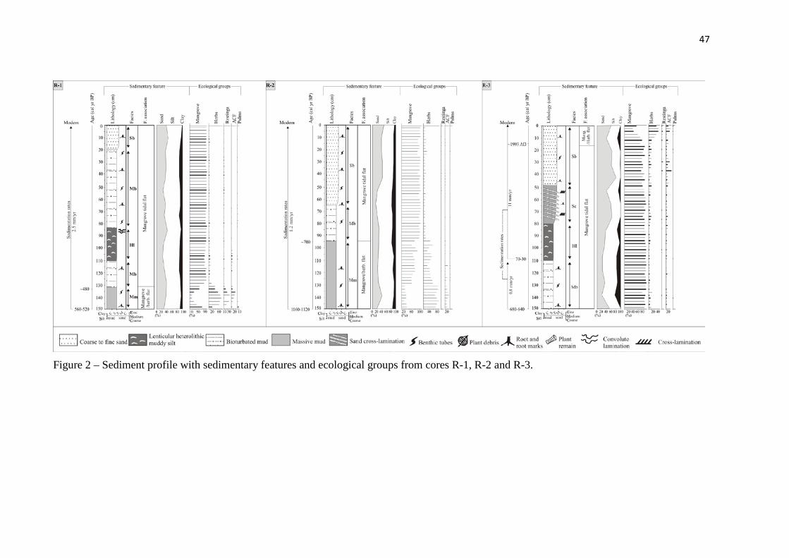
47
Figure 2 – Sediment profile with sedimentary features and ecological groups from cores R-1, R-2 and R-3.
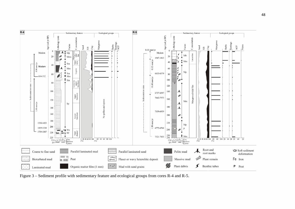
48
Figure 3 – Sediment profile with sedimentary feature and ecological groups from cores R-4 and R-5.
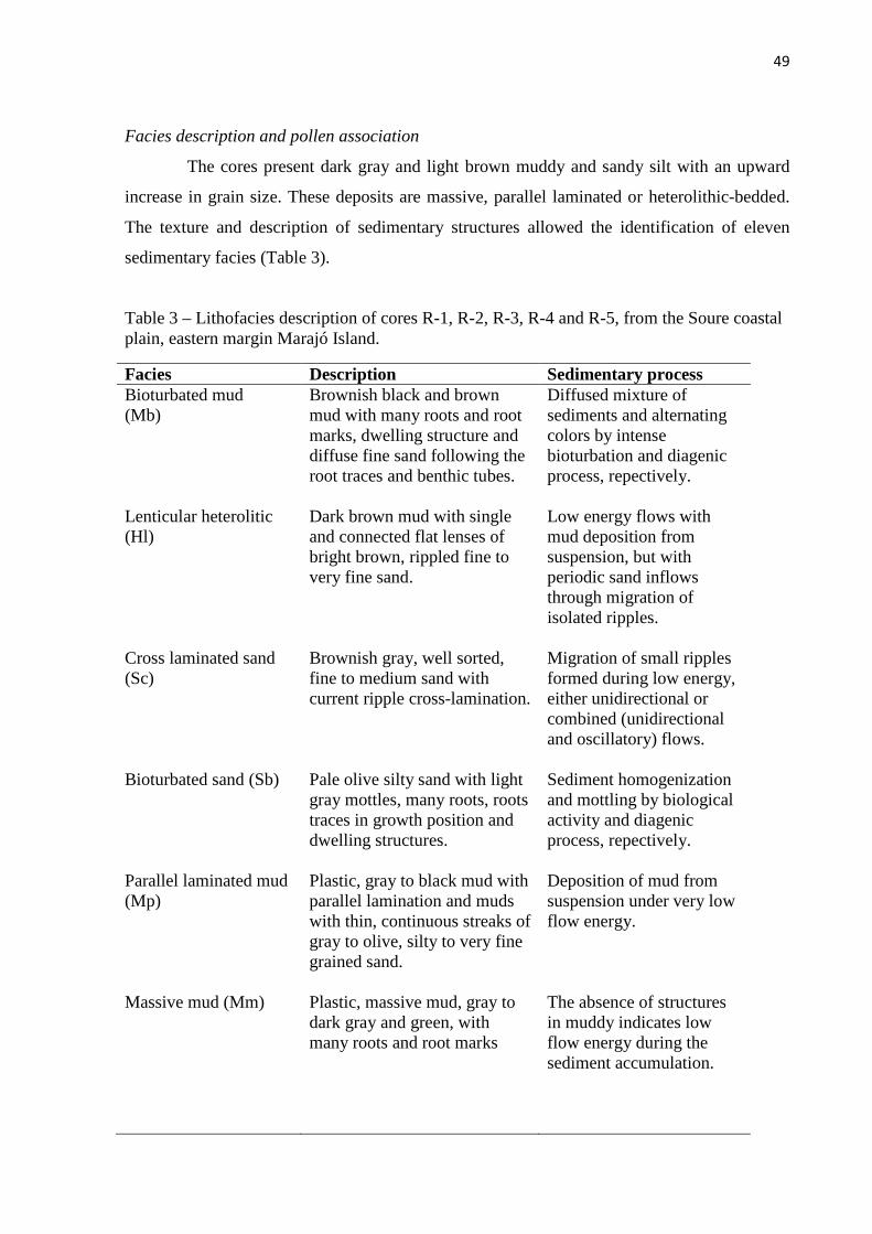
49
Facies description and pollen association
The cores present dark gray and light brown muddy and sandy silt with an upward
increase in grain size. These deposits are massive, parallel laminated or heterolithic-bedded.
The texture and description of sedimentary structures allowed the identification of eleven
sedimentary facies (Table 3).
Table 3 – Lithofacies description of cores R-1, R-2, R-3, R-4 and R-5, from the Soure coastal plain, eastern margin Marajó Island.
Facies Description Sedimentary process Bioturbated mud (Mb)
Brownish black and brown mud with many roots and root marks, dwelling structure and diffuse fine sand following the root traces and benthic tubes.
Diffused mixture of sediments and alternating colors by intense bioturbation and diagenic process, repectively.
Lenticular heterolitic (Hl)
Dark brown mud with single and connected flat lenses of bright brown, rippled fine to very fine sand.
Low energy flows with mud deposition from suspension, but with periodic sand inflows through migration of isolated ripples.
Cross laminated sand (Sc)
Brownish gray, well sorted, fine to medium sand with current ripple cross-lamination.
Migration of small ripples formed during low energy, either unidirectional or combined (unidirectional and oscillatory) flows.
Bioturbated sand (Sb) Pale olive silty sand with light gray mottles, many roots, roots traces in growth position and dwelling structures.
Sediment homogenization and mottling by biological activity and diagenic process, repectively.
Parallel laminated mud (Mp)
Plastic, gray to black mud with parallel lamination and muds with thin, continuous streaks of gray to olive, silty to very fine grained sand.
Deposition of mud from suspension under very low flow energy.
Massive mud (Mm) Plastic, massive mud, gray to dark gray and green, with many roots and root marks
The absence of structures in muddy indicates low flow energy during the sediment accumulation.
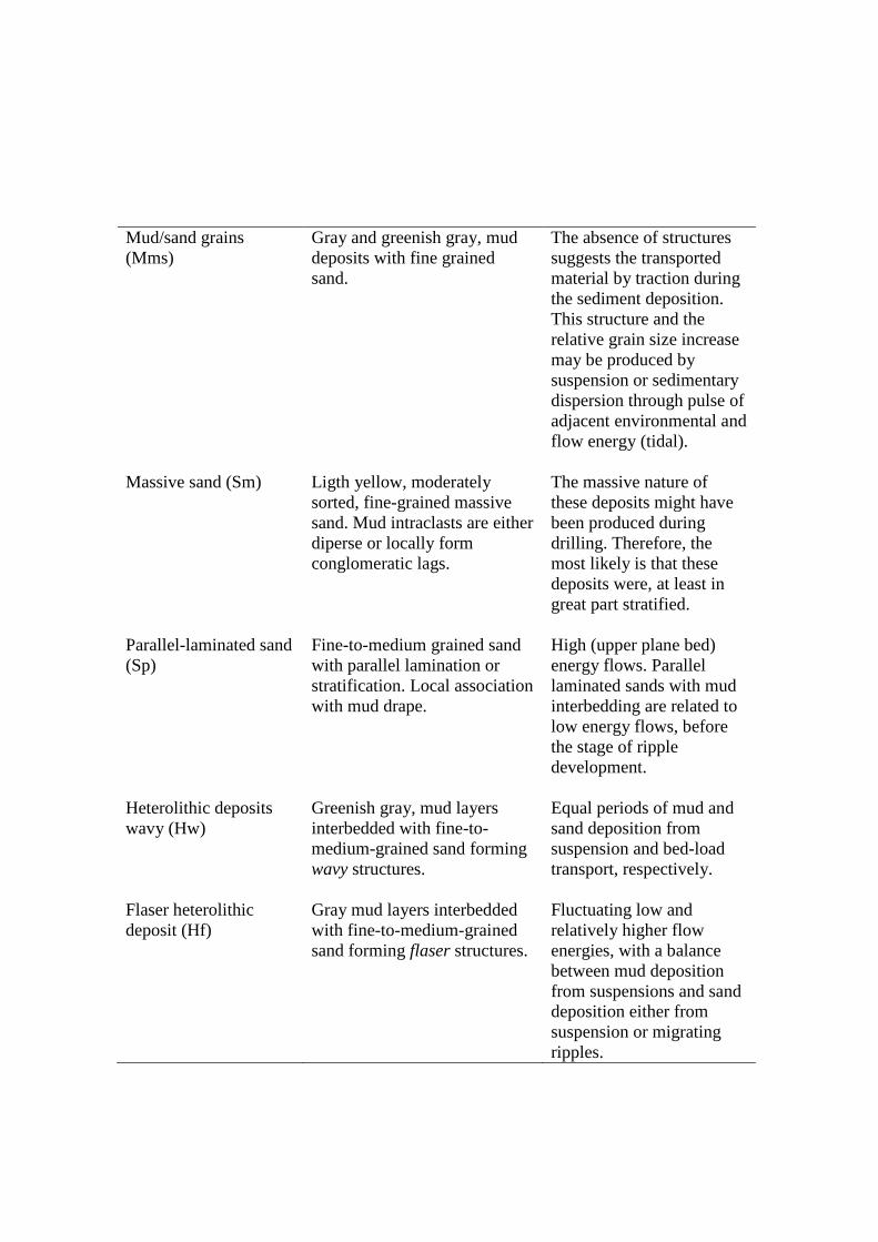
Mud/sand grains (Mms)
Gray and greenish gray, mud deposits with fine grained sand.
The absence of structures suggests the transported material by traction during the sediment deposition. This structure and the relative grain size increase may be produced by suspension or sedimentary dispersion through pulse of adjacent environmental and flow energy (tidal).
Massive sand (Sm) Ligth yellow, moderately sorted, fine-grained massive sand. Mud intraclasts are either diperse or locally form conglomeratic lags.
The massive nature of these deposits might have been produced during drilling. Therefore, the most likely is that these deposits were, at least in great part stratified.
Parallel-laminated sand (Sp)
Fine-to-medium grained sand with parallel lamination or stratification. Local association with mud drape.
High (upper plane bed) energy flows. Parallel laminated sands with mud interbedding are related to low energy flows, before the stage of ripple development.
Heterolithic deposits wavy (Hw)
Greenish gray, mud layers interbedded with fine-to-medium-grained sand forming wavy structures.
Equal periods of mud and sand deposition from suspension and bed-load transport, respectively.
Flaser heterolithic deposit (Hf)
Gray mud layers interbedded with fine-to-medium-grained sand forming flaser structures.
Fluctuating low and relatively higher flow energies, with a balance between mud deposition from suspensions and sand deposition either from suspension or migrating ripples.

A cluster analysis of pollen assemblages allowed the definition of pollen zones for
each sediment core. The pollen diagrams show pollen types (Figures 4, 5, 6, 7 and 8) and the
proportions represented by the different ecological groups (Figures 2 and 3). Pollen
concentration and pollen influx values ranged from 5,000 to 100,000 grains cm-3 and from
100 to 8,000 grains cm-2 yr-1, respectively.
The sediment and pollen analyses allowed the identification of five facies associations,
described below.
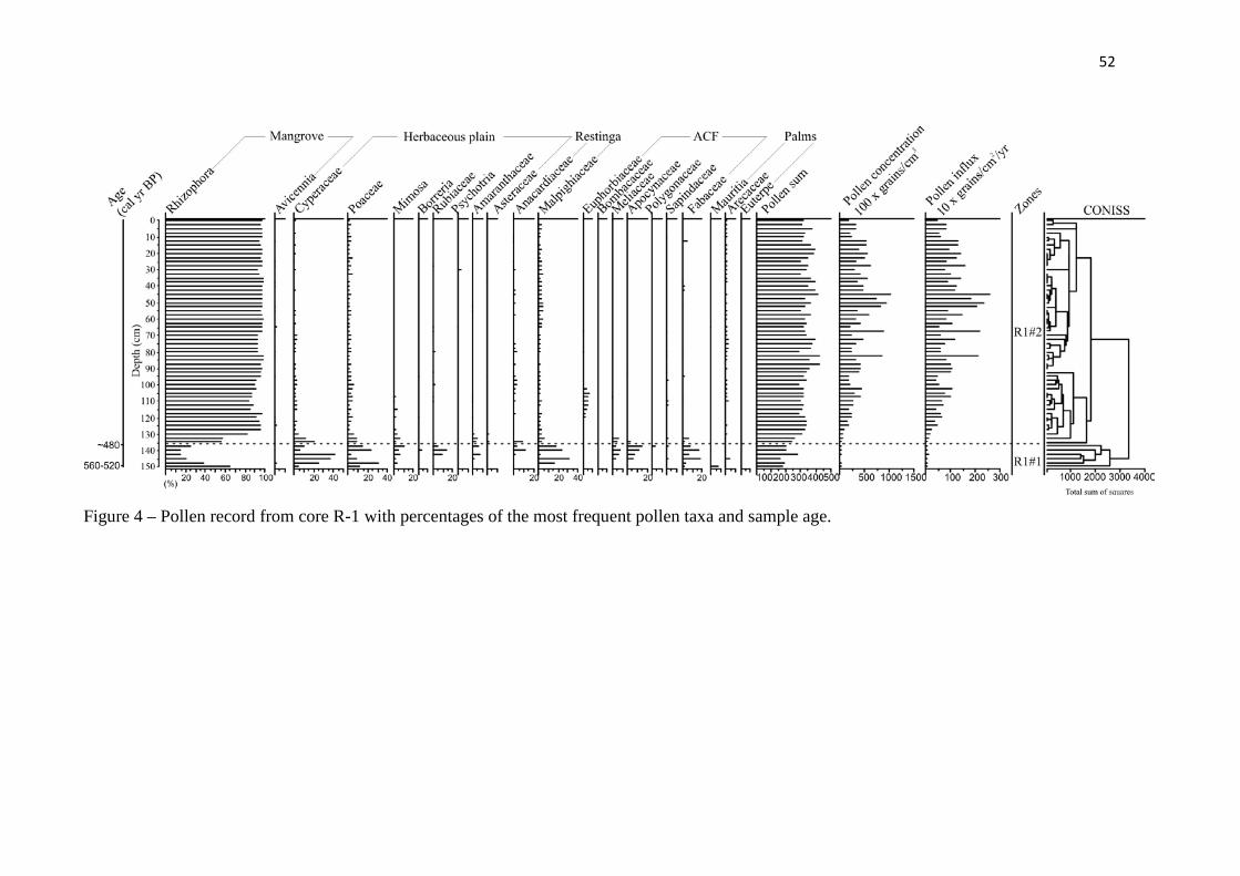
52
Figure 4 – Pollen record from core R-1 with percentages of the most frequent pollen taxa and sample age.
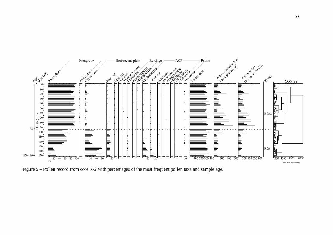
53
Figure 5 – Pollen record from core R-2 with percentages of the most frequent pollen taxa and sample age.
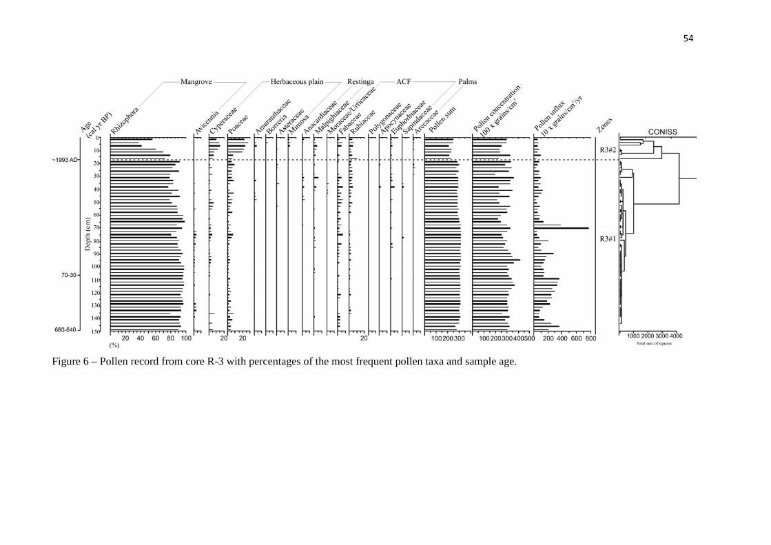
54
Figure 6 – Pollen record from core R-3 with percentages of the most frequent pollen taxa and sample age.
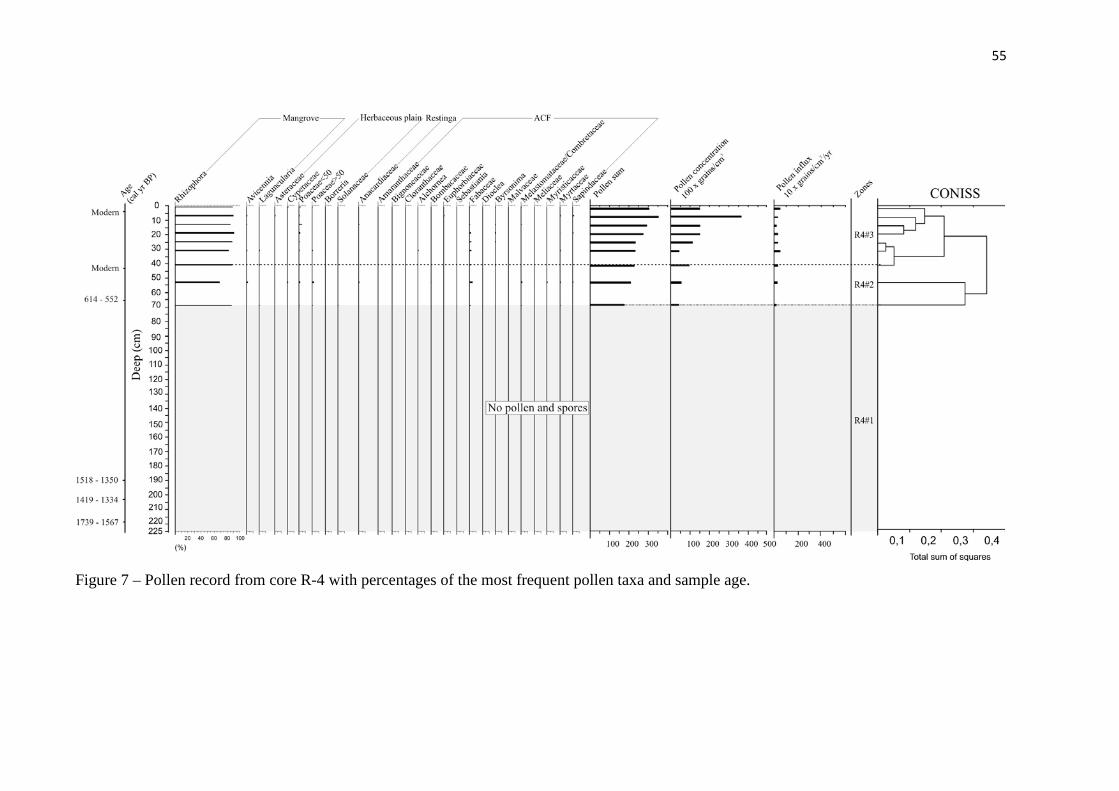
55
Figure 7 – Pollen record from core R-4 with percentages of the most frequent pollen taxa and sample age.
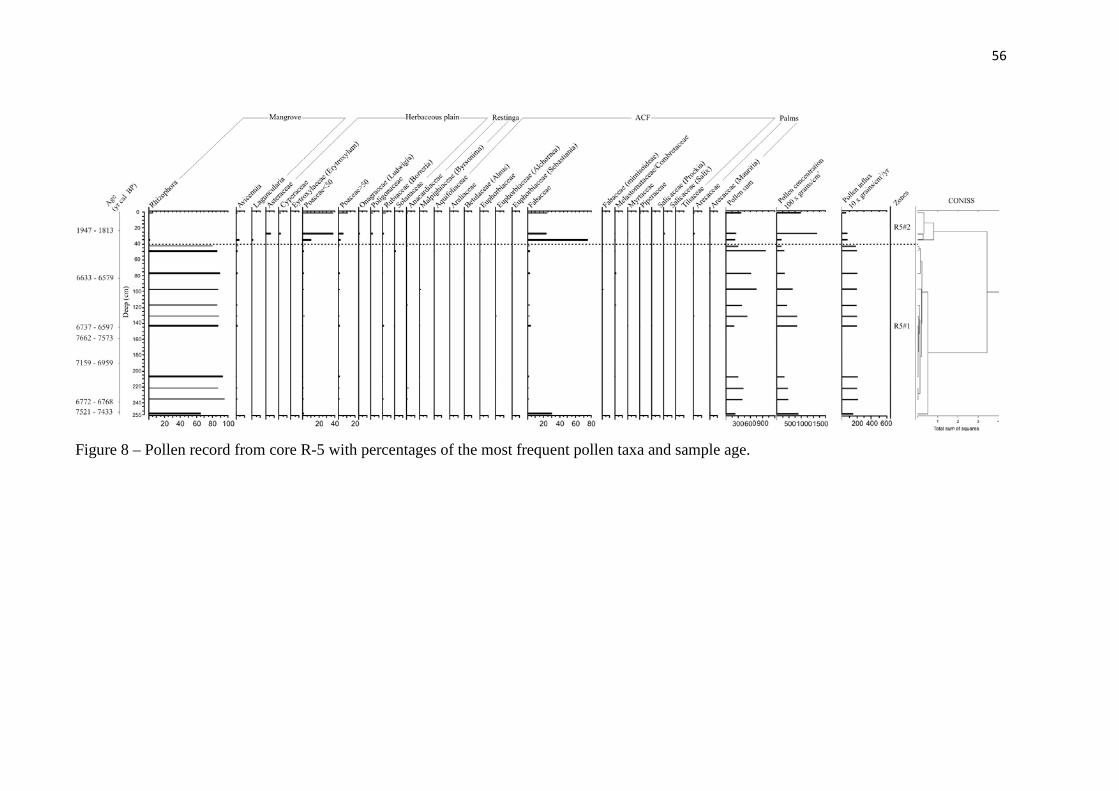
56
Figure 8 – Pollen record from core R-5 with percentages of the most frequent pollen taxa and sample age.
57
Mangrove/herbaceous flat facies association
The mangrove/herbaceous flat occurs along the interval 150-135, 150-95 and 15-0
cm in R-1, R-2 and R-3, respectively (Figure 2).This unit consists mostly of massive mud
(facies Mm) with plant debris, and bioturbated coarse- to fine-grained sand (facies Sb).
The pollen assemblages of this association correspond to zone R1#1 (Figure 4), R2#1
(Figure 5) and R3#2 (Figure 6). Zone R1#1 (560-520 cal yr BP until ~ 480 cal yr BP) is
characterized by pollen of Rhizophora (15-65%), Cyperaceae (5-40%), Poaceae (2-30%),
Fabaceae (2-20%), Mimosaceae (2-10%), Borreria (~5%), Rubiaceae (5-15%) and
Amaranthaceae (2-7%).
Zone R2#1 (1,160-1,120 cal yr BP until ~700 cal yr BP) is characterized by pollen of
Rhizophora (10-75%), Cyperaceae (10-70%), Poaceae (5-20%), Fabaceae (2-10%) and
Rubiaceae (1-5%). The presence of pollen from the Amazon coastal forest can be observed in
this zone, represented by Euphorbiaceae (5-20%). Zone R3#2 (1993 AD until present) is
characterized mainly by a decrease in Rhizophora (35-80%) and increase in Poaceae (10-
25%) and Cyperaceae (5-15%) pollen.
Mangrove flat facies association
Cores R-1 and R-2 show the mangrove tidal flat along the intervals 135-0 and 95-0
cm, while this association occurs at depth interval 150-15 cm in R-3, 40-0 cm in R-4, and
between 255 and 15 cm in R-5 (Figures 2 and 3). The deposit consists of mud with flat lenses
of rippled sand (facies Hl). Bioturbated mud (facies Mb), bioturbated sand (facies Sb),
massive sand (Sm) and cross laminated fine-grained sand (facies Sc) are also present in this
association. In addition, core R-1 displays mud with convolute lamination, which may contain
roots, root channels and dwelling structures produced by benthic fauna.
The pollen assemblages of this association correspond to zone R1#2 (~480 cal yr BP
– modern, Figure 4), zone R2#2 (~700 cal yr BP – modern, Figure 5) and to zone R3#1 (~660
cal yr BP – ~1993 AD, Figure 6) in its entirety. This association also occurs in zone R4#3
(~600 cal yr BP – modern, Figure 7), and zone R5#1 (~7,500 cal yr BP – ~3,200 cal yr BP,
Figure 8) and is characterized by the predominance of mangrove pollen, mainly represented
by Rhizophora (40-95%). Pollen of herbaceous plain vegetation of the Cyperaceae, Poaceae,
Fabaceae, Mimosaceae, Borreria, Rubiaceae, Amaranthaceae and Asteraceae occur at very
low percentages (<30%).
Lagoon facies association
This association is mainly represented by massive mud (facies Mm) and massive
sand (facies Sm), with mangrove pollen along zone R4#2 (70-40 cm). These deposits contain
root and root marks, benthic tubes, mud and very fine silt to medium sand. The presence of
mangrove is marked by Rhizophora (65-90%) and Avicennia (5%) pollen.
Foreshore facies association
This association occurs in core R-4 (225-70 cm), about > 1,650 to 580 cal yr B.P.,
corresponding to zone R4#1. It consists of parallel-laminated, fine- to medium-grained sand
(facies Sp). Roots, root marks and benthic tubes are present locally. Bedding is
marked by heavy minerals and/or clay films (Figure 3). The base is characterized by very
fine- to medium-grained sand, and either heterolithic wavy deposits (facies Hw) and flaser
heterolithic deposits (Hf). In addition, plants debris and oxidized iron blades are present.
These deposits did not contain pollen grains.
Lake facies association
This association occurs only in core R-5 (R5#2), between 55 and 0 cm (Figures 3 and
8). It is characterized by massive mud (facies Mm) and bioturbated mud (Mb). Benthic tubes,
oxidized iron concretions, plant debris and root marks were present. These deposits are
marked by greater amounts of pollen which is characteristics of ACF (3-75%), herbs (2-55%),
aquatic vegetation (0-10%) and ferns (1-5%), and accompanied by a decrease in mangrove
pollen (85-0%).
Discussion
Pollen signal and vegetation changes in Marajó Island during the Holocene (central and
eastern coastal zone)
There often exists two pollen components in sediment—pollen from ‘‘local’’
vegetation, and background pollen from ‘‘regional’’ vegetation (Janssen, 1966, 1973;
Andersen, 1967, 1970; Sugita, 1994). Pollen records of lacustrine sediment cores include
pollen sourced from vegetation surrounding the lake, considering that winds blow from
various directions. Thus, the proportion of the pollen signal provided by each vegetation type
is distance-weighted (e.g. Davis, 2000). Some empirical studies have reported pollen
transport in rivers (e.g. Brush and Brush, 1972; Solomon et al., 1982). Flume experiments
suggest that pollen grains will settle out into sediment when water velocity is lower than
0.3 m s-1, and therefore grains can remain in suspension and be transported long distances
when water velocity is greater than 0.3 m s-1 (Brush and Brush, 1972). According to Xu et al.
(2012), the pollen found in lakes originates from three components: an aerial component
mainly carried by wind, a fluvial catchment component transported by rivers and a third
waterborne component transported by surface wash. Overall, vegetational composition within
the “aerial catchment” differs from that of the hydrological catchment.
Influx rates of modern pollen from the Bragança Peninsula, located 150 km east of
the study area, indicate that Rhizophora is a very prolific pollen producer within mangroves,
while Avicennia and Laguncularia produce lesser amounts. Pollen influx rates of Rhizophora
and Avicennia in the Rhizophora/Avicennia dominated forest area are approximately 14,500
and 450 grains cm-2 yr-1, respectively. Pollen traps in the herbaceous plain site, which are
located at least 1 – 2 km away from the nearest Rhizophora trees and 100 m away from the
nearest Avicennia, document an average of 410 Rhizophora grains cm-2 yr-1 and an average of
8 Avicennia grains cm-2 yr-1. This indicates that a certain amount of Rhizophora pollen grains
can be transported by wind, while wind transportation of Avicennia pollen is very low
(Behling et al., 2001).
Core R-5, sampled from a lake and currently dominated by herbaceous vegetation
(Figure 1), indicates change in vegetation patterns. This change likely extends at least to the
drainage basin area and is expected to be reflected in pollen records of the lacustrine
sediments. Pollen contributions from different vegetation type in the surrounding landscape
are also expected to decrease with increasing distance from the lake. For this reason the pollen
record of core R-5, at least between depths of 0 and 55 cm, is likely more representative of
vegetation dynamics of eastern Marajó Island than those records from cores R-1, R-2, R-3 and
R-4, collected from tidal flats.
The results obtained from pollen and sedimentological analyses suggest vegetation
changes during the last seven thousand years. The sedimentary deposits consisting of
mud/sand alternations formed under oscillating flow energy contain three pollen groups.
Vegetation shifts most likely occurred under the influence of fluctuating flow velocity
asymmetry in tidal flats. Data suggest a tidal mud flat colonized by mangroves in the central
region of the island between ~7,500 cal yr BP and ~3,200 cal yr BP, as recorded in core R-5
(Figures 3 and 8), and other cores from Lake Arari on Marajó Island during the early and mid
Holocene (Smith et al., 2011, 2012).
During the late Holocene in the hinterland of Marajó Island, mangroves were largely
replaced by herbaceous vegetation. Mangroves occurred on tidal flats on the northeastern
coast of the island (i.e, core R-2) at least since ~1,150 cal yr BP, and continued to be recorded
in cores R-1, R-4 and R-3 at 540, 580 and 660 cal yr BP, respectively.
The migration of mangroves recorded in core R-4 (Figure 7) may be a natural
response to coast progradation, following stabilization and mud accumulation. Progradation
could have also affected other areas of the Marajó coastline, where várzea became established
instead of mangrove (Cohen et al., 2008 and Smith et al., 2011).
Therefore, mangrove vegetation at the mouth of the Amazon River retreated to a
narrow area of northeastern Marajo Island. An increment in river discharge near Marajó
Island during the late Holocene constitutes a hypothesis for this isolation (Guimarães et al.,
2012; Smith et al., 2012). This process could be responsible for the modern decrease in tidal
water salinity along the littoral (0–6 ‰, Santos et al., 2008). It is noteworthy that tidal water
salinity is greater in this northeastern area than elsewhere on the island, and this is related to
the southeast-northwest trending current along the littoral. This current displaces brackish
waters from the marine influenced littoral (Figure 1a).
Greater tidal water salinity during the early and mid Holocene could be attributed to
the episode of Atlantic sea-level rise recorded in other parts of South America (e.g., Suguio et
al., 1985; Tomazelli, 1990; Rull et al.,1999; Hesp et al., 2007; Angulo et al., 2008). This
event could have also produced a marine incursion along the Pará littoral, where the RSL
stabilized at its current level between 7,000 and 5,000 yr BP (e.g. Cohen et al., 2005a; Vedel
et al., 2006). A transgressive phase occurred on Marajó Island in the early to mid-late
Holocene. Subsequently, there was a return to the more continental conditions that prevail
today in the study area (Rossetti et al., 2008). This history of RSL fluctuations on Marajó
Island seems to have been affected by tectonic activity during the Late Pleistocene and
Holocene (Rossetti et al., 2008; Rossetti, et al., 2012). Hence, transgression was favored
during increased subsidence, when space was created to accommodate new sediments.
Tectonic stability seems to have prevailed during the mid to late Holocene, leading to
coastal progradation that culminated with more continental conditions prevailing on the
island.
The post-glacial sea-level rise, likely combined with tectonic subsidence, may have
increased tidal water salinity. Salinity might have further increased due to low river discharge
resulting from increased aridity during the early and mid Holocene. If river systems are
considered to be integrators of rainfall over large areas (Amarasekera et al., 1997), variations
in the discharge of the Amazon River during the Holocene may be a consequence of changes
in rainfall rates, as recorded in many different regions of the Amazon Basin (e.g. Bush and
Colinvaux, 1988; Absy et al., 1991; Sifeddine et al., 1994; Desjardins et al., 1996; Gouveia et
al., 1997; Pessenda et al., 1998a,b, 2001; Behling and Hooghiemstra, 2000; Freitas et al.,
2001; Sifeddine et al. 2001; Weng et al., 2002; Bush et al., 2007; Guimarães et al., 2012).
Mangrove dynamics during the last decades in the eastern coastal zone of Marajó Island
Mangroves preferentially occupy mudflats. Mangrove retreat along the coastline may
be caused by landward sand migration, which covers the mudflat and asphyxiates the
vegetation (Cohen and Lara, 2003). During the last one hundred years, the increase inflow
energy on mangroves (Furukawa and Wolanski, 1996) evidenced at Marajó Island by the
upward mud into sand (Figures 1f and 1g) may also contribute to mangrove retraction, as
recorded in the upper section of core R-3 (Figure 6).
The disappearance of mangrove vegetation along the Marajó coastline has been
mostly caused by erosion and landward sand migration above mangrove mud sediments
(Figure 1g). At present, this region is exposed to wave action and tidal currents in Marajó
Bay, which apparently have caused the retreat of the coastline, and consequently a reduction
in the area covered by mangrove vegetation.
This process is also evidenced along the Pará littoral. The marine influenced littoral
in the central area of peninsulas also shows a transition between herbaceous vegetation and
mangrove forest, with mangrove migration toward the topographically highest herbaceous
areas most likely in response to the modern RSL rise (Cohen and Lara 2003; Cohen et al.,
2009).
Greater exposure to tidal influence may have been driven by RSL rise and/or by
greater river water discharge. As previously mentioned, the RSL rise in this area may be
related to tectonics and it may reduce areas favorable for mangrove development (Blasco et
al. 1996) leading to the migration of this ecosystem to topographically more elevated terrains
(Cohen and Lara, 2003, Cohen et al., 2005a).
Climate fluctuations (Molodkov and Bolikhovskaya, 2002) which impacted rainfall
(e.g. Absy et al., 1991; Pessenda et al., 1998a,b, 2001, 2004; Behling and Costa, 2000;
Freitas, et al., 2001; Maslin and Bruns, 2000) could also have caused changes in river flow
and estuarine salinity gradients (Lara and Cohen, 2006). This can also affect the RSL
(Mörner, 1996, 1999).
The area covered by herbaceous vegetation, located in topographically higher areas,
suffered a reduction during the last decades (Cohen and Lara, 2003) and centuries (Cohen et
al., 2005a,b). This indicates an increase in the RSL, which has caused erosion and deposition

of sand over mud deposits. This trend was also observed on the Taperebal (12 km north of
Bragança) (Vedel et al., 2006). The effects of RSL rise were also observed in cores taken
from São Caetano de Odivelas and Salinópolis (Cohen et al., 2009) in the northeastern coast
of Pará, in the eastern Amazon region.
Conclusions
The integration of pollen data and facies descriptions of five sediment cores indicates
a tidal mud flat colonized by mangroves in the interior of Marajó Island between ~7,500 cal
yr BP and ~3,200 cal yr BP. During the late Holocene, mangroves became isolated and grew
on a small area (100-700 m width) of the northeastern part of the island. This likely results
from lower tidal water salinity caused by a wet period that resulted in greater river discharge
during the late Holocene. The northeastern area of the island exhibits relatively greater tidal
water salinity, due to the southeast-northwest trending littoral current which brings brackish
waters from more marine influenced areas. It has provided a refuge for the mangroves of
Marajó Island.
Over the last century, the increase in flow energy evidenced by upward mud/sand
transitions also contributes to mangrove retraction, as recorded in the upper part of core R-3.
This is mainly due to landward sand migration, which covers the mudflat and asphyxiates the
mangrove. The increase in flow energy and exposure to tidal influence may have been driven
by the RSL rise, either associated with global fluctuations or tectonic subsidence, and/or by
the increase in river water discharge. These processes can modify the size of the area
occupied by mangroves.
As demonstrated by this work, using a combination of proxies is efficient for
palaeoenvironmental reconstruction, where mangrove retraction during the late
Holocene shows the high degree of sensitivity of this ecosystem to the sequence
of environmental variables discussed here.
CHAPTER III:
AN INTER-PROXY APPROACH TO ASSESSING THE
DEVELOPMENT OF THE AMAZONIAN MANGROVE,
DURING THE HOLOCENE
* Paper accepted on Vegetation History and Archaeobotany
Abstract
The mangrove dynamic on Marajó Island at the mouth of the Amazon River during
the past ~7500 cal yr BP was studied using multiple proxies, including sedimentary facies,
pollen, δ13C, δ15N and C/N ratio, temporally synchronized with fifteen sediment samples to 14C dating. The results allowed to propose a palaeogeographical development with changes in
vegetation, hydrology and organic matter dynamics. Today, the island’s interior is occupied
by várzea/herbaceous vegetation (freshwater vegetation), but during the early-middle
Holocene mangroves with accumulation of estuarine organic matter had colonized the tidal
mud flats. This was caused by post-glacial sea-level rise, which combined with tectonic
subsidence, produced a marine transgression. It is likely that the relatively higher marine
influence at the studied area was favored by reduced Amazon River discharge, caused by a
dry period occurred during the early and middle Holocene. During the late Holocene, there
was a reduction of mangrove vegetation and the contribution of freshwater organic matter to
the area was higher than early and middle Holocene. This suggests a decrease in marine
influence during the late Holocene that led to a gradual migration of mangroves from the
central region to the northeastern littoral zone of island, and, consequently, its isolation since
at least ~1150 cal yr BP. This is probably a result from lower tidal water salinity caused by a
wet period that resulted in greater river discharge during the late Holocene. This work details
chronologically and spatially the contraction of mangrove forest from northeastern Marajó
Island under the influence of Amazon climatic changes that allows to propose a model with
successive phases of sediment accumulation and vegetation change according to marine-
freshwater influence gradient. As demonstrated by this work, using a combination of proxies
is efficient for establish a relationship between the changes in estuarine salinity gradient and
depositional environment/vegetation.
Keywords: Amazon coastal area; Holocene; isotopes; sea-level; vegetation; climate change
Introduction
Mangrove distributions are considered indicators of coastal changes (Blasco et al.,
1996) and have fluctuated throughout geological and human history. The area covered by
mangrove is influenced by complex interactions involving gradients of tidal flooding
frequency, nutrient availability and soil salt concentration across the intertidal area (Hutchings
and Saenger, 1987; Wolanski et al., 1990). The geomorphic setting of mangrove systems also
comprises a range of inter-related factors such as substrate types, coastal processes, sediment,
and freshwater delivery. All of these factors influence the occurrence and survivorship of
mangroves (Semeniuk, 1994).
Investigations along the littoral zone of the Brazilian Amazon using
sedimentological, palynological and isotope data have revealed evidence of
expansion/contraction of mangroves during the Holocene (Cohen et al., 2008; Lara and
Cohen, 2009; Cohen et al., 2009; Guimarães et al., 2010, 2012; Smith et al., 2011, 2012).
Those mangrove variations have been attributed to the combination of post-glacial sea-level
rise (Suguio et al., 1985; Tomazelli, 1990; Angulo and Suguio, 1995; Martin et al., 1996;
Angulo and Lessa, 1997; Angulo et al., 1999; Rull et al., 1999; Hesp et al., 2007; Angulo et
al., 2008), tectonic subsidence (Miranda et al., 2009; Castro et al., 2010; Rossetti et al., 2012)
and changes in the Amazon River discharge as consequence of variations in rainfall (e.g.
Bush and Colinvaux, 1988; Absy et al., 1991; Sifeddine et al., 1994; Desjardins et al., 1996;
Gouveia et al., 1997; Pessenda et al., 1998a, 2001; Behling and Hooghiemstra, 2000; Freitas
et al., 2001; Sifeddine et al. 2001; Weng et al., 2002; Bush et al., 2007).
The mangroves of northern Brazil began to develop along their current position
during the early and middle-Holocene (Behling et al., 2001; Behling and Costa, 2001; Cohen
et al., 2005a, Vedel et al., 2006), due to the stabilization of relative sea-level (RSL) after the
post-glacial sea-level rise that invaded the embayed coast and broad valleys (Cohen et al.,
2005a; Souza-Filho et al., 2006). Currently, the coastal zone influenced by the Amazon River
(fluvial sector – northwestern coastline) is occupied by várzea/herbaceous vegetation
(freshwater vegetation). However, pollen data indicate that marine influence and mangrove
vegetation (brackish water vegetation) were more expressive than they are today on Marajó
Island (Smith et al., 2011, 2012; França et al., 2012), as well as on Macapá coast (Guimarães
et al., 2012) between >8800 and ~2300 cal yr BP and >5500 and ~5200 cal yr BP,
respectively.
During the late Holocene, it is likely that the replacement of brackish/marine water
by freshwater vegetation at the mouth of Amazon River was caused by a wetter climate,

which generated a river discharge increase (Bush and Colinvaux, 1988; Absy et al., 1991;
Desjardins et al., 1996; Pessenda et al., 1998a,b; Freitas et al., 2001). A higher river
discharger has maintained low tidal water salinity surrounding of Marajó Island (0–6 ‰,
Santos et al., 2008), while the marine influenced littoral zone presents a relatively higher tidal
water salinity than the sector near the Amazon River (Figure 1a, Cohen et al., 2012).
Previously, Smith et al. (2011) and França et al. (2012) indicated a mangrove
contraction in the Marajó Island during the Holocene. The main objective of this investigation
is to establish a relationship between the changes in estuarine salinity gradient from Amazon
River and the mangrove dynamics of Marajó Island-Northern Brazil. Then, this work presents
the integration of δ13C, δ15N, total organic carbon (TOC), C/N ratio, facies analysis and pollen
data, synchronized chronologically with fifteen radiocarbon dated (14C) samples. For this
purpose, material extracted from five cores, with depth between 150 and 256 cm, was
collected from the eastern coast of Marajó Island.
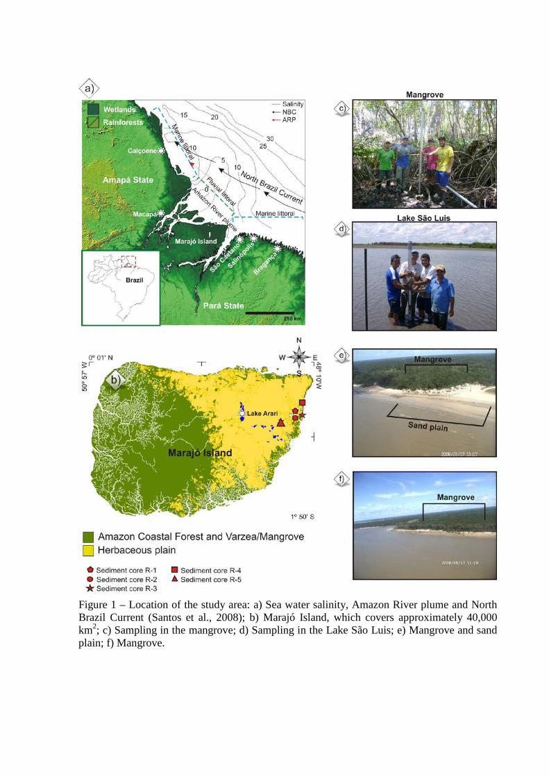
Figure 1 – Location of the study area: a) Sea water salinity, Amazon River plume and North Brazil Current (Santos et al., 2008); b) Marajó Island, which covers approximately 40,000 km2; c) Sampling in the mangrove; d) Sampling in the Lake São Luis; e) Mangrove and sand plain; f) Mangrove.
Study site
Geological and geomorphological setting
The Marajó Island has an area of about 40,000 km2. The study sites are located in the
central eastern region of this island (0°39’16.96”S/48°40’13.79”W to
0°55’51.35”S/48°28’16.96”W), northern Brazil, on the coastal plain situated at the mouth of
the Amazon River (Cohen et al., 2008; Smith et al., 2011, 2012). Geologically, the island is
located in the Pará Platform. The eastern margin presents a topographical range of less than 5
m and extends inland to the maximum extent of the tidal influence zone, which limits the
coastal plateau (França and Sousa-Filho, 2006). This region has a low relief, averaging only
4-6 m above modern sea-level (Rossetti et al., 2007, 2008, 2012), and is dominated by
Holocene sedimentation, which is slightly depressed relative to the western side (Behling et
al., 2004; Rossetti et al., 2007; Lara and Cohen, 2009). Along the eastern portion, the
Barreiras Formation is represented by sandstones and mudstones followed by post-Barreiras
deposits, that thicken toward the west in the sub-surface (Rossetti et al., 2008).
Regional climate and oceanographic characteristics
The climate is warm and humid tropical with an annual precipitation averaging 2300
mm (Lima et al., 2005). The seasonality of regional precipitation is influenced by several
factors, including the migration of the Inter Tropical Convergence Zone (ITCZ), due to
changing Atlantic sea surface temperatures (SST), moist trade winds from the tropical
Atlantic, evapotranspiration from the forest itself, and the coupled onset and intensity of
Amazon convection (Marengo et al., 1993, 2001; Nobre and Shukla, 1996; Fu et al., 2001;
Liebmann and Marengo, 2001). The rainy season occurs between the months of December
and May and a drier period between June and November. Average temperatures range
between 25º and 29º C. The region is dominated by a regime of semidiurnal meso- and
macrotides (tidal range of 2 to 4 m and 4 to 6 m, respectively) with variations during the
spring tide, between 3.6 and 4.7 m (DHN, 2003). The mean Amazon River discharge is about
170,000 m3 s-1 (at Óbidos city), with maximum and minimum outflow of 270,000 and 60,000
m3 s-1 (ANA, 2003). Consequently, the river discharge and hydrodynamic conditions allow a
strong reduction of water salinity along the Amazon River and its adjacent coast (Figure 1a)
(Vinzon et al., 2008; Rosario et al., 2009). Furthermore the structure of the Amazon River
plume is controlled by the North Brazilian Current, which induces a northwestern flow with
speeds of 40–80 cm/s over the continental shelf (Lentz, 1995).
Modern vegetation
The modern vegetation consists of natural open areas dominated by Cyperaceae and
Poaceae (herbaceous flats), which occur mainly in the eastern side of Marajó Island. The
várzea vegetation (swamp seasonally and permanently inundated by freshwater) is composed
by wetlands trees such as Euterpe oleraceae and Hevea guianensis, while the “terra firme”
vegetation, represented by the Amazon Coastal Forest (ACF) unit, is characterized by Cedrela
odorata, Hymenaea courbaril and Manilkara huberi (Behling et at., 2004; Cohen et al., 2008;
Smith et al., 2011, 2012). The várzea and ACF dominate the western side of Marajó Island
(Figure 1a). Narrow and elongated belts of dense ombrophilous forest are also present along
riverbanks (Rossetti et al., 2008). The restinga (shrub and herb vegetation that occurs on sand
plains and on dunes close to the shore line) is dominated by Anacardiaceae and
Malpighiaceae. The mangroves are colonized by Rhizophora, Avicennia and Laguncularia
(Cohen et al., 2008).
The mangrove on the studied island, occurs within specific topographic zones (see
Cohen and Lara, 2003; Cohen et al., 2005a, 2005b, 2008, 2009) depending on physical
(sediment type, e.g., Duke et al., 1997) and chemical (Hutching and Saenger, 1987; Wolanski
et al., 1990) characteristics, and are currently present in small areas in the northeastern coast
with 100-700 m width. The mangrove of our study area are classified as Rhizophora-
dominated "fringe forests" reaching 20 m in height, with a presence of Avicennia at highest
elevations above mean spring tide level, inundation frequency.
Materials and methods
Analysis of sedimentary facies, pollen, δ13C, δ15N, TOC and C/N ratio were
conducted following the results of radiocarbon dating (14C), to assess the development of the
Amazonian mangrove and organic matter source. The sediment cores (R-1; R-2 and R-3)
were collected during the summer season (November 2008), using Russian sampling
equipment (Cohen, 2003) and two others (R-4 and R-5) with a vibracorer (Martin et al., 1995)
using an aluminum tube.
Sampling
Five specific sites were selected for shallow coring that represent different
morphological aspects and vegetations at Marajó Island (Figure 1b). The sediment cores were
sampled from an area colonized by mangroves mainly characterized by Rhizophora mangle
(R-4, S0º39'37"/W48º29'3" and R-2, S0º40'23"/W48º29'38") and mixture várzea/mangrove
(R-1, S0º40'26"/W48º29'37") characterized by Rhizophora mangle and others taxa such as
Arecaceae (Euterpe oleracea; Mauritia flexuosa); Araceae (Montrichardia arborescens);
Aizoaceae (Sesuvium); Acanthaceae (Avicennia germinans); Cyperaceae; Heliconiaceae;
Musaceae; Myrtaceae (Psidium guajava); Poaceae (Olyra); Pteridaceae (Acrostichum
auereum).
The core R-3 (S0º40'25"/W48º29'35") was taken from an area occupied by
herbaceous and restinga vegetation characterized by Arecaceae (Euterpe oleracea; Mauritia
flexuosa); Birzonimia; Cyperaceae; Poaceae (Olyra); Malpiguiaceae, while the R-5
(S0º55'41"/W48º39'47", 15 km from shoreline) was sampled from an area colonized only by
herbaceous vegetation mainly represented by Convovulaceae; Rubiaceae; Cyperaceae and
Poaceae.
Facies analysis
For analysis of sedimentary facies, the cores were submitted to X-ray to identify
sedimentary structures. The sediment grain size was obtained by laser diffraction using a
Laser Particle Size SHIMADZU SALD 2101 in the Laboratory of Chemical
Oceanography/UFPA. Approximately 0.5 g of each sample was submitted to H2O2 to remove
the organic matter, and residual sediments were disaggregated by ultrasound before the
determination of grain size (França, 2010). The sediment grain size distribution followed the
methods of Wentworth (1922), with sand (2-0.0625 mm), silt (62.5-3.9 µm) and clay fraction
(3.9-0.12 µm). The graphics were elaborated using the Sysgran Program (Camargo, 1999).
Following the methods of Harper (1984) and Walker (1992). Facies analysis included
description of color (Munsell Color, 2009), lithology, texture and structure. The sedimentary
facies were codified following Miall (1978).
Pollen analysis
For pollen analysis, 1 cm3 samples were taken at 2.5 cm intervals along sediment
cores R-1, R-2 and R-3 (183 samples), in order to observe a high resolution to vegetation
changes. From sediment cores R-4 and R-5, 24 and 36 samples were collected, respectively.
Prior to processing, one tablet of exotic Lycopodium spores (Stockmarr, 1971) was added to
each sediment sample to allow the calculation of pollen concentration (grains cm-3) and pollen
influx rates (grains cm-2 yr-1). All samples were prepared using standard analytical techniques
for pollen including acetolysis (Faegri and Iversen, 1989). Sample residues were placed in
Eppendorf microtubes and kept in a glycerol gelatin medium. Reference morphological
descriptions (Roubik and Moreno, 1991; Behling, 1993; Herrera and Urrego, 1996; Colinvaux
et al., 1999) and pollen collection of the Laboratory of Coastal Dynamics/Federal University
of Pará were consulted for identification of pollen grains and spores. A minimum of 300
pollen grains were counted in each sample. The pollen sum excludes fern spores, algae and
micro-foraminifers. Pollen and spore data are presented in diagrams as percentages of the
pollen sum (França et al., 2012). Taxa were grouped into mangrove, herbaceous plain
elements, Restinga (coastal forest vegetation), palms, and Amazon coastal forest (ACF).
Software packages TILIA and TILIAGRAPH were used to calculate and plot pollen diagrams
(Grimm, 1987).
Organic geochemistry
A total of 236 samples (6-50 mg) were collected at 5 cm intervals from the sediment
cores in order to associate to vegetation changes and understand also the organic matter
source change. Samples of leaves, roots, etc., were separated and treated with 4% HCl to
eliminate carbonates, washed with distilled water until the pH reached 6, dried at 50oC and
homogenized. These samples were used for total organic carbon and nitrogen analyses,
carried out at the Stable Isotope Laboratory of the Center for Nuclear Energy in Agriculture
(CENA/USP). The results are expressed as a percentage of dry weight, with analytical
precision of 0.09 and 0.07%, respectively. The 13C and 15N results are expressed as δ13C and
δ15N with respect to the VPDB standard and atmospheric air, respectively, using the following
conventional notations:
δ13C (‰)=[(R1sample/R2standard)-1] . 1000
δ15N (‰)=[(R3sample/R4standard)-1] . 1000
where R1sample and R2standard are the 13C/12C ratio of the sample and standard, as well as
R3sample and R4standard are the 15N/14N, respectively. Analytical precision is ±0.2‰ (Pessenda et
al., 2004).
Surface sample sediment cores were collected to verify the isotopic composition of
modern organic matter to compare different isotopic signature between them. Leaves of the
most representative trees of the study area were also sampled for isotopic δ13C determination
to define photosynthetic characteristics of regional vegetation (Table 1). The application of
carbon isotopes is based on the 13C composition of C3 (trees) and C4 (grasses) plants and its
preservation in SOM (sedimentary organic matter). Especially in the Amazon ecosystem with
predominance of C3 plants values, the isotope values tend to increase towards the deeper
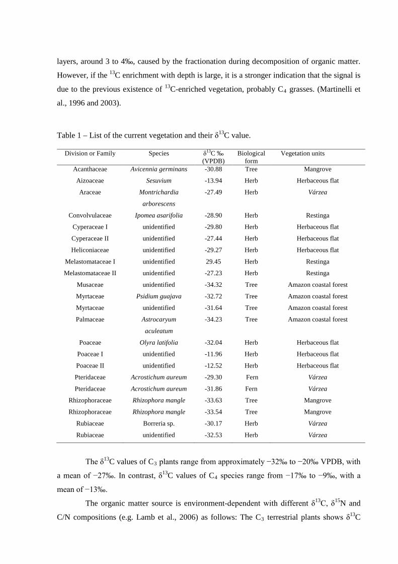
layers, around 3 to 4‰, caused by the fractionation during decomposition of organic matter.
However, if the 13C enrichment with depth is large, it is a stronger indication that the signal is
due to the previous existence of 13C-enriched vegetation, probably C4 grasses. (Martinelli et
al., 1996 and 2003).
Table 1 – List of the current vegetation and their δ13C value.
Division or Family Species δ13C ‰ (VPDB)
Biological form
Vegetation units
Acanthaceae Avicennia germinans -30.88 Tree Mangrove
Aizoaceae Sesuvium -13.94 Herb Herbaceous flat
Araceae Montrichardia
arborescens
-27.49 Herb Várzea
Convolvulaceae Ipomea asarifolia -28.90 Herb Restinga
Cyperaceae I unidentified -29.80 Herb Herbaceous flat
Cyperaceae II unidentified -27.44 Herb Herbaceous flat
Heliconiaceae unidentified -29.27 Herb Herbaceous flat
Melastomataceae I unidentified 29.45 Herb Restinga
Melastomataceae II unidentified -27.23 Herb Restinga
Musaceae unidentified -34.32 Tree Amazon coastal forest
Myrtaceae Psidium guajava -32.72 Tree Amazon coastal forest
Myrtaceae unidentified -31.64 Tree Amazon coastal forest
Palmaceae Astrocaryum
aculeatum
-34.23 Tree Amazon coastal forest
Poaceae Olyra latifolia -32.04 Herb Herbaceous flat
Poaceae I unidentified -11.96 Herb Herbaceous flat
Poaceae II unidentified -12.52 Herb Herbaceous flat
Pteridaceae Acrostichum aureum -29.30 Fern Várzea
Pteridaceae Acrostichum aureum -31.86 Fern Várzea
Rhizophoraceae Rhizophora mangle -33.63 Tree Mangrove
Rhizophoraceae Rhizophora mangle -33.54 Tree Mangrove
Rubiaceae Borreria sp. -30.17 Herb Várzea
Rubiaceae unidentified -32.53 Herb Várzea
The δ13C values of C3 plants range from approximately −32‰ to −20‰ VPDB, with
a mean of −27‰. In contrast, δ13C values of C4 species range from −17‰ to −9‰, with a
mean of −13‰.
The organic matter source is environment-dependent with different δ13C, δ15N and
C/N compositions (e.g. Lamb et al., 2006) as follows: The C3 terrestrial plants shows δ13C
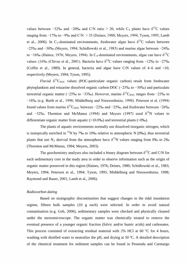
values between −32‰ and −20‰ and C/N ratio > 20, while C4 plants have δ13C values
ranging from −17‰ to −9‰ and C/N > 35 (Deines, 1980; Meyers, 1994; Tyson, 1995; Lamb
et al., 2006). In C3-dominated environments, freshwater algae have δ13C values between
−25‰ and −30‰ (Meyers, 1994; Schidlowski et al., 1983) and marine algae between −24‰
to −16‰ (Haines, 1976; Meyers, 1994). In C4-dominated environments, algae can have δ13C
values ≤16‰ (Chivas et al., 2001). Bacteria have δ13C values ranging from −12‰ to −27‰
(Coffin et al., 1989). In general, bacteria and algae have C/N values of 4–6 and <10,
respectively (Meyers, 1994; Tyson, 1995).
Fluvial δ13CPOC values (POC-particulate organic carbon) result from freshwater
phytoplankton and estuarine dissolved organic carbon-DOC (−25‰ to −30‰) and particulate
terrestrial organic matter (−25‰ to −33‰). However, marine δ13CPOC ranges from −23‰ to
−18‰ (e.g. Barth et al., 1998; Middelburg and Nieuwenhuize, 1998). Peterson et al. (1994)
found values from marine δ13CDOC between −22‰ and −25‰, and freshwater between −26‰
and −32‰. Thornton and McManus (1994) and Meyers (1997) used δ15N values to
differentiate organic matter from aquatic (>10.0‰) and terrestrial plants (~0‰).
The plants of aquatic environments normally use dissolved inorganic nitrogen, which
is isotopically enriched in 15N by 7‰ to 10‰ relative to atmospheric N (0‰), thus terrestrial
plants that use N2 derived from the atmosphere have δ15N values ranging from 0‰ to 2‰
(Thornton and McManus, 1994; Meyers, 2003).
The geochemistry analyses also included a binary diagram between δ13C and C/N for
each sedimentary core in the study area in order to observe information such as the origin of
organic matter preserved in this region (Haines, 1976; Deines, 1980; Schidlowski et al., 1983;
Meyers, 1994; Peterson et al., 1994; Tyson, 1995; Middelburg and Nieuwenhuize, 1998;
Raymond and Bauer, 2001; Lamb et al., 2006).
Radiocarbon dating
Based on stratigraphic discontinuities that suggest changes in the tidal inundation
regime, fifteen bulk samples (10 g each) were selected. In order to avoid natural
contamination (e.g. Goh, 2006), sedimentary samples were checked and physically cleaned
under the stereomicroscope. The organic matter was chemically treated to remove the
eventual presence of a younger organic fraction (fulvic and/or humic acids) and carbonates.
This process consisted of extracting residual material with 2% HCl at 60 °C for 4 hours,
washing with distilled water to neutralize the pH, and drying at 50 ºC. A detailed description
of the chemical treatment for sediment samples can be found in Pessenda and Carmargo
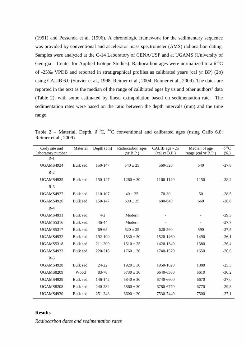
(1991) and Pessenda et al. (1996). A chronologic framework for the sedimentary sequence
was provided by conventional and accelerator mass spectrometer (AMS) radiocarbon dating.
Samples were analyzed at the C-14 Laboratory of CENA/USP and at UGAMS (University of
Georgia – Center for Applied Isotope Studies). Radiocarbon ages were normalized to a δ13C
of -25‰ VPDB and reported in stratigraphical profiles as calibrated years (cal yr BP) (2σ)
using CALIB 6.0 (Stuvier et al., 1998; Reimer et al., 2004; Reimer et al., 2009). The dates are
reported in the text as the median of the range of calibrated ages by us and other authors’ data
(Table 2), with some estimated by linear extrapolation based on sedimentation rate. The
sedimentation rates were based on the ratio between the depth intervals (mm) and the time
range.
Table 2 – Material, Depth, δ13C, 14C conventional and calibrated ages (using Calib 6.0; Reimer et al., 2009).
Cody site and laboratory number
Material Depth (cm) Radiocarbon ages (yr B.P.)
CALIB age - 2σ (cal yr B.P.)
Median of age range (cal yr B.P.)
δ13C (‰)
R-1
UGAMS4924 Bulk sed. 150-147 540 ± 25 560-520 540 -27,8
R-2
UGAMS4925 Bulk sed. 150-147 1260 ± 30 1160-1120 1150 -28,2
R-3
UGAMS4927 Bulk sed. 110-107 40 ± 25 70-30 50 -28,5
UGAMS4926 Bulk sed. 150-147 690 ± 25 680-640 660 -28,8
R-4
UGAMS4931 Bulk sed. 4-2 Modern - - -29,3
UGAMS5316 Bulk sed. 46-44 Modern - - -27,7
UGAMS5317 Bulk sed. 69-65 620 ± 25 620-560 590 -27,5
UGAMS4932 Bulk sed. 192-190 1530 ± 30 1520-1460 1490 -26,1
UGAMS5318 Bulk sed. 211-209 1510 ± 25 1420-1340 1380 -26,4
UGAMS4933 Bulk sed. 220-218 1760 ± 30 1740-1570 1650 -26,6
R-5
UGAMS4928 Bulk sed. 24-22 1920 ± 30 1950-1820 1880 -25,3
UGAMS8209 Wood 83-78 5730 ± 30 6640-6580 6610 -30,2
UGAMS4929 Bulk sed. 146-142 5840 ± 30 6740-6600 6670 -27,0
UGAMS8208 Bulk sed. 240-234 5860 ± 30 6780-6770 6770 -29,3
UGAMS4930 Bulk sed. 251-248 6600 ± 30 7530-7440 7500 -27,1
Results
Radiocarbon dates and sedimentation rates
Radiocarbon dates for cores R-1 to R-5 are shown in Table 2 (range since ~7500 cal
yr BP). Sedimentation rates are between 0.1 and 10 mm yr−1. Although the rates are nonlinear
between the dated points, they are within the vertical accretion range of 0.1 to 10 mm yr−1 of
mangrove forests as reported by other authors (e.g. Bird, 1980; Spenceley, 1982 and Cahoon
and Lynch, 1997; Behling et al., 2004; Cohen et al., 2005a, 2008, 2009; Vedel et al., 2006;
Guimarães et al., 2010).
δ13C values of modern vegetation
Twenty-two species of the most representative vegetation were collected at the study
site. The δ13C values range between −34.23‰ and −27.23‰, and indicate a predominance of
C3 plants (Table 1). The contribution of C4 to the δ13C signal in the sediment is restricted to
the Poaceae (unidentified) with a mean value of −12.24‰, and Aizoaceae (Sesuvium) with a
value of −13.94‰.
Facies, pollen description and isotope values of the sediment cores
The cores present dark gray and light brown muddy and sandy silt sediments with an
upward increase in grain size. These deposits are massive, parallel laminated or heterolithic.
The texture analysis and description of sedimentary structures of the materials collected in the
tidal flat, together with pollen records, isotopic (δ13C and δ15N), TOC and C/N values,
allowed five facies associations to be defined (Table 3).
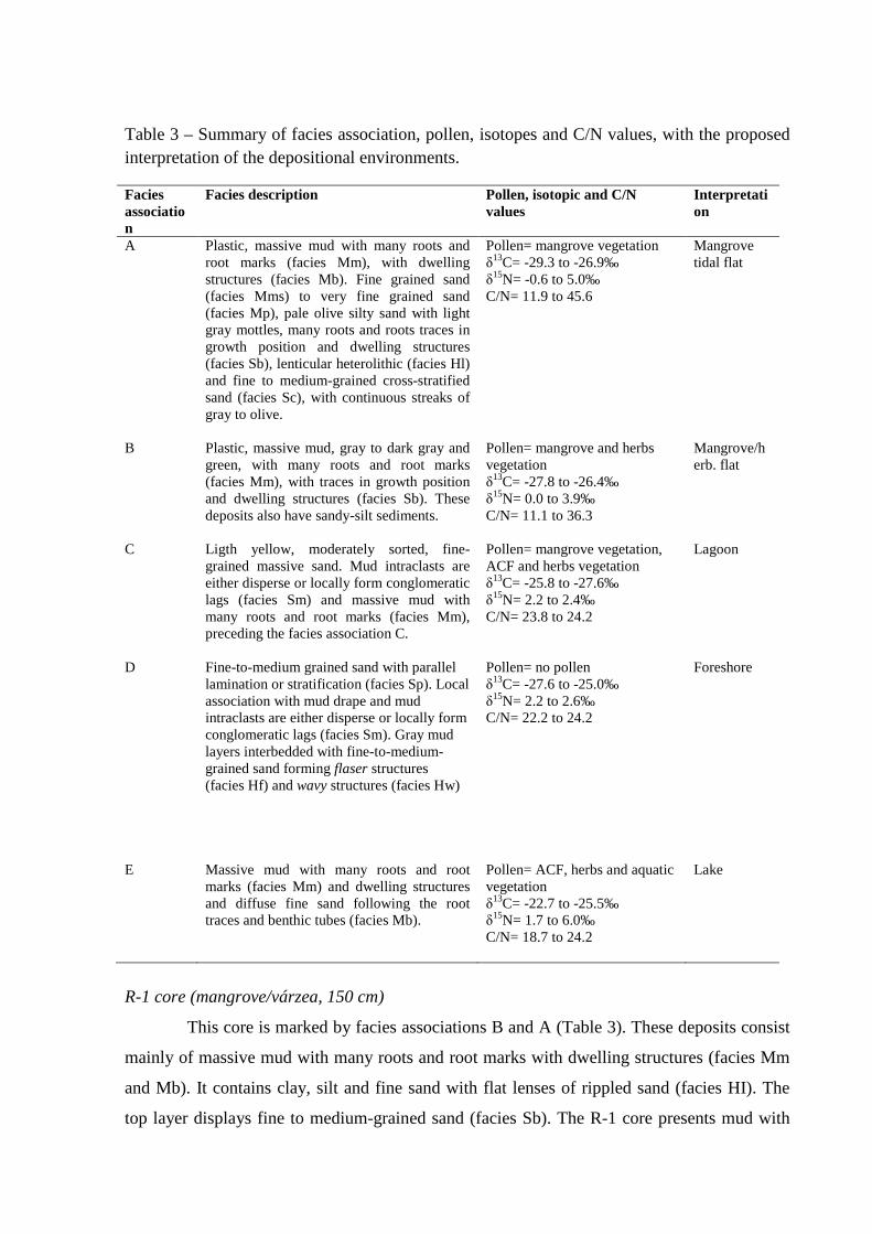
Table 3 – Summary of facies association, pollen, isotopes and C/N values, with the proposed interpretation of the depositional environments.
Facies association
Facies description Pollen, isotopic and C/N values
Interpretation
A Plastic, massive mud with many roots and root marks (facies Mm), with dwelling structures (facies Mb). Fine grained sand (facies Mms) to very fine grained sand (facies Mp), pale olive silty sand with light gray mottles, many roots and roots traces in growth position and dwelling structures (facies Sb), lenticular heterolithic (facies Hl) and fine to medium-grained cross-stratified sand (facies Sc), with continuous streaks of gray to olive.
Pollen= mangrove vegetation δ13C= -29.3 to -26.9‰ δ15N= -0.6 to 5.0‰ C/N= 11.9 to 45.6
Mangrove tidal flat
B Plastic, massive mud, gray to dark gray and green, with many roots and root marks (facies Mm), with traces in growth position and dwelling structures (facies Sb). These deposits also have sandy-silt sediments.
Pollen= mangrove and herbs vegetation δ13C= -27.8 to -26.4‰ δ15N= 0.0 to 3.9‰ C/N= 11.1 to 36.3
Mangrove/herb. flat
C Ligth yellow, moderately sorted, fine-grained massive sand. Mud intraclasts are either disperse or locally form conglomeratic lags (facies Sm) and massive mud with many roots and root marks (facies Mm), preceding the facies association C.
Pollen= mangrove vegetation, ACF and herbs vegetation δ13C= -25.8 to -27.6‰ δ15N= 2.2 to 2.4‰ C/N= 23.8 to 24.2
Lagoon
D Fine-to-medium grained sand with parallel lamination or stratification (facies Sp). Local association with mud drape and mud intraclasts are either disperse or locally form conglomeratic lags (facies Sm). Gray mud layers interbedded with fine-to-medium-grained sand forming flaser structures (facies Hf) and wavy structures (facies Hw)
Pollen= no pollen δ13C= -27.6 to -25.0‰ δ15N= 2.2 to 2.6‰ C/N= 22.2 to 24.2
Foreshore
E Massive mud with many roots and root marks (facies Mm) and dwelling structures and diffuse fine sand following the root traces and benthic tubes (facies Mb).
Pollen= ACF, herbs and aquatic vegetation δ13C= -22.7 to -25.5‰ δ15N= 1.7 to 6.0‰ C/N= 18.7 to 24.2
Lake
R-1 core (mangrove/várzea, 150 cm)
This core is marked by facies associations B and A (Table 3). These deposits consist
mainly of massive mud with many roots and root marks with dwelling structures (facies Mm
and Mb). It contains clay, silt and fine sand with flat lenses of rippled sand (facies HI). The
top layer displays fine to medium-grained sand (facies Sb). The R-1 core presents mud with
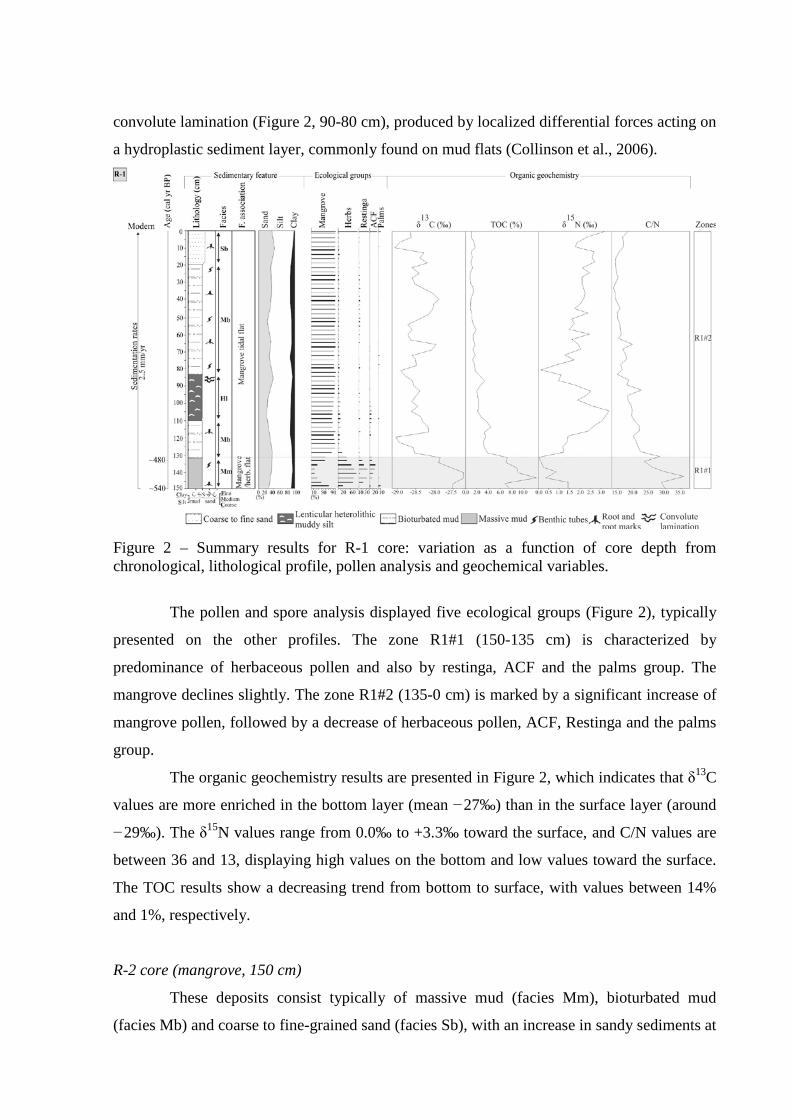
convolute lamination (Figure 2, 90-80 cm), produced by localized differential forces acting on
a hydroplastic sediment layer, commonly found on mud flats (Collinson et al., 2006).
Figure 2 – Summary results for R-1 core: variation as a function of core depth from chronological, lithological profile, pollen analysis and geochemical variables.
The pollen and spore analysis displayed five ecological groups (Figure 2), typically
presented on the other profiles. The zone R1#1 (150-135 cm) is characterized by
predominance of herbaceous pollen and also by restinga, ACF and the palms group. The
mangrove declines slightly. The zone R1#2 (135-0 cm) is marked by a significant increase of
mangrove pollen, followed by a decrease of herbaceous pollen, ACF, Restinga and the palms
group.
The organic geochemistry results are presented in Figure 2, which indicates that δ13C
values are more enriched in the bottom layer (mean −27‰) than in the surface layer (around
−29‰). The δ15N values range from 0.0‰ to +3.3‰ toward the surface, and C/N values are
between 36 and 13, displaying high values on the bottom and low values toward the surface.
The TOC results show a decreasing trend from bottom to surface, with values between 14%
and 1%, respectively.
R-2 core (mangrove, 150 cm)
These deposits consist typically of massive mud (facies Mm), bioturbated mud
(facies Mb) and coarse to fine-grained sand (facies Sb), with an increase in sandy sediments at
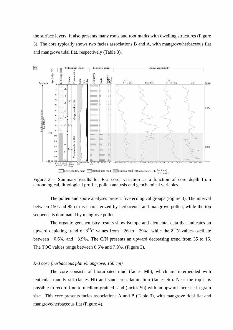
the surface layers. It also presents many roots and root marks with dwelling structures (Figure
3). The core typically shows two facies associations B and A, with mangrove/herbaceous flat
and mangrove tidal flat, respectively (Table 3).
Figure 3 – Summary results for R-2 core: variation as a function of core depth from chronological, lithological profile, pollen analysis and geochemical variables.
The pollen and spore analyses present five ecological groups (Figure 3). The interval
between 150 and 95 cm is characterized by herbaceous and mangrove pollen, while the top
sequence is dominated by mangrove pollen.
The organic geochemistry results show isotope and elemental data that indicates an
upward depleting trend of δ13C values from −26 to −29‰, while the δ15N values oscillate
between −0.6‰ and +3.9‰. The C/N presents an upward decreasing trend from 35 to 16.
The TOC values range between 0.5% and 7.9%. (Figure 3).
R-3 core (herbaceous plain/mangrove, 150 cm)
The core consists of bioturbated mud (facies Mb), which are interbedded with
lenticular muddy silt (facies Hl) and sand cross-lamination (facies Sc). Near the top it is
possible to record fine to medium-grained sand (facies Sb) with an upward increase in grain
size. This core presents facies associations A and B (Table 3), with mangrove tidal flat and
mangrove/herbaceous flat (Figure 4).
Figure 4 – Summary results for R-3 core: variation as a function of core depth from chronological, lithological profile, pollen analysis and geochemical variables.
The interval between 150 and 15 cm is marked by a dominance of mangrove pollen,
while the top is marked by a decrease in mangrove, and an increase in herbaceous pollen, and
trees and shrubs from ACF.
The isotope data and elemental analysis results are presented in Figure 4. The δ13C
values oscillate between −28.3‰ and −27‰. The δ15N values present an upward increase
from +0.6‰ to +4.8‰. The C/N shows a decreasing trend from 26.2 to 11.1 in surface. The
TOC results exhibit values between 0.3% and 2% with higher values at 120 cm.
R-4 core (mangrove, 225 cm)
The deposits are dominantly sandy sediments at the bottom, with mud present at
shallow depth. This core grades downward into heterolitic deposits (facies Hf and Hw),
consisting of massive sand (facies Sm) or, less commonly, parallel laminated, fine to very
fine-grained sand (facies Sp). Plant debris and overload structures are locally present. These
deposits show association D, C and A (Table 3), thus a phase of foreshore, with tidal channel
(facies Hf and Hw), lagoon with mangrove and mangrove tidal flat, respectively (Figure 5).
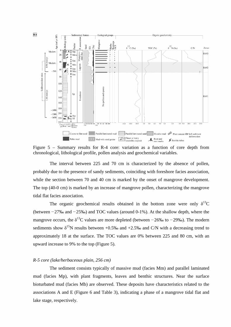
Figure 5 – Summary results for R-4 core: variation as a function of core depth from chronological, lithological profile, pollen analysis and geochemical variables.
The interval between 225 and 70 cm is characterized by the absence of pollen,
probably due to the presence of sandy sediments, coinciding with foreshore facies association,
while the section between 70 and 40 cm is marked by the onset of mangrove development.
The top (40-0 cm) is marked by an increase of mangrove pollen, characterizing the mangrove
tidal flat facies association.
The organic geochemical results obtained in the bottom zone were only δ13C
(between −27‰ and −25‰) and TOC values (around 0-1%). At the shallow depth, where the
mangrove occurs, the δ13C values are more depleted (between −26‰ to −29‰). The modern
sediments show δ15N results between +0.5‰ and +2.5‰ and C/N with a decreasing trend to
approximately 18 at the surface. The TOC values are 0% between 225 and 80 cm, with an
upward increase to 9% to the top (Figure 5).
R-5 core (lake/herbaceous plain, 256 cm)
The sediment consists typically of massive mud (facies Mm) and parallel laminated
mud (facies Mp), with plant fragments, leaves and benthic structures. Near the surface
bioturbated mud (facies Mb) are observed. These deposits have characteristics related to the
associations A and E (Figure 6 and Table 3), indicating a phase of a mangrove tidal flat and
lake stage, respectively.
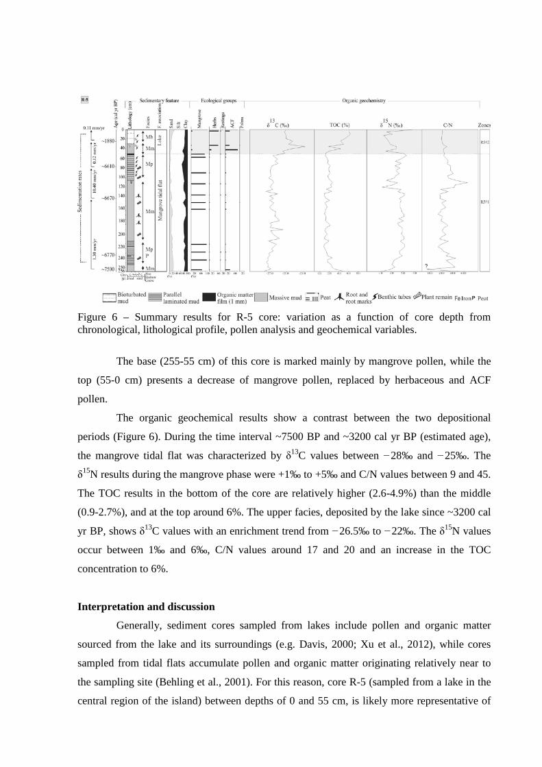
Figure 6 – Summary results for R-5 core: variation as a function of core depth from chronological, lithological profile, pollen analysis and geochemical variables.
The base (255-55 cm) of this core is marked mainly by mangrove pollen, while the
top (55-0 cm) presents a decrease of mangrove pollen, replaced by herbaceous and ACF
pollen.
The organic geochemical results show a contrast between the two depositional
periods (Figure 6). During the time interval ~7500 BP and ~3200 cal yr BP (estimated age),
the mangrove tidal flat was characterized by δ13C values between −28‰ and −25‰. The
δ15N results during the mangrove phase were +1‰ to +5‰ and C/N values between 9 and 45.
The TOC results in the bottom of the core are relatively higher (2.6-4.9%) than the middle
(0.9-2.7%), and at the top around 6%. The upper facies, deposited by the lake since ~3200 cal
yr BP, shows δ13C values with an enrichment trend from −26.5‰ to −22‰. The δ15N values
occur between 1‰ and 6‰, C/N values around 17 and 20 and an increase in the TOC
concentration to 6%.
Interpretation and discussion
Generally, sediment cores sampled from lakes include pollen and organic matter
sourced from the lake and its surroundings (e.g. Davis, 2000; Xu et al., 2012), while cores
sampled from tidal flats accumulate pollen and organic matter originating relatively near to
the sampling site (Behling et al., 2001). For this reason, core R-5 (sampled from a lake in the
central region of the island) between depths of 0 and 55 cm, is likely more representative of
vegetation and organic matter of eastern Marajó Island than the records from cores R-1, R-2,
R-3 and R-4, collected from tidal flats with a smaller spatial representativeness of vegetation
and organic matter (Cohen et al., 2008; Smith et al., 2011; 2012).
Thus, the results obtained from sedimentary features, pollen and geochemical
analyses from Marajó Island suggest significant changes in vegetation and organic matter
source during at least the last seven thousand years. The data suggest the delimitation of three
phases, with a tidal flat colonized by mangrove in the central region of the island between
~7500 and ~3200 cal yr BP (estimated age), and with relatively higher contributions of
estuarine organic matter between ~7500 and ~6500 cal yr BP, as recorded in core R-5
(Figures 6, 7 and 8). During ~3200 and ~1150 cal yr BP in the hinterland of Marajó Island,
mangroves were largely replaced by herbaceous vegetation, characterizing the second phase.
The third phase is marked by migration and isolation of mangrove to the east coast of the
island since ~1150 cal yr BP at the earliest (i.e, core R-2), and is recorded in cores R-1, R-4
and R-3 at ~540, ~580 and ~660 cal yr BP, respectively (Figure 8).
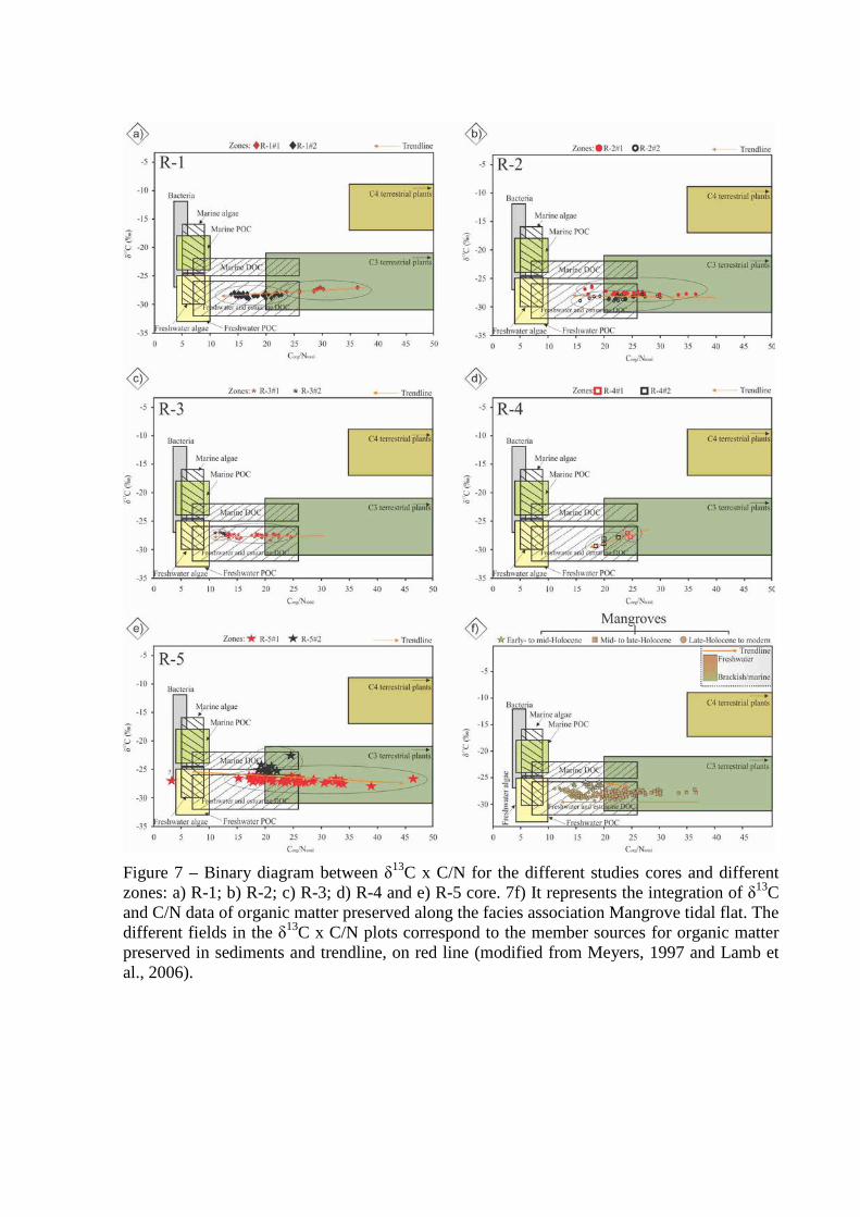
Figure 7 – Binary diagram between δ13C x C/N for the different studies cores and different zones: a) R-1; b) R-2; c) R-3; d) R-4 and e) R-5 core. 7f) It represents the integration of δ13C and C/N data of organic matter preserved along the facies association Mangrove tidal flat. The different fields in the δ13C x C/N plots correspond to the member sources for organic matter preserved in sediments and trendline, on red line (modified from Meyers, 1997 and Lamb et al., 2006).
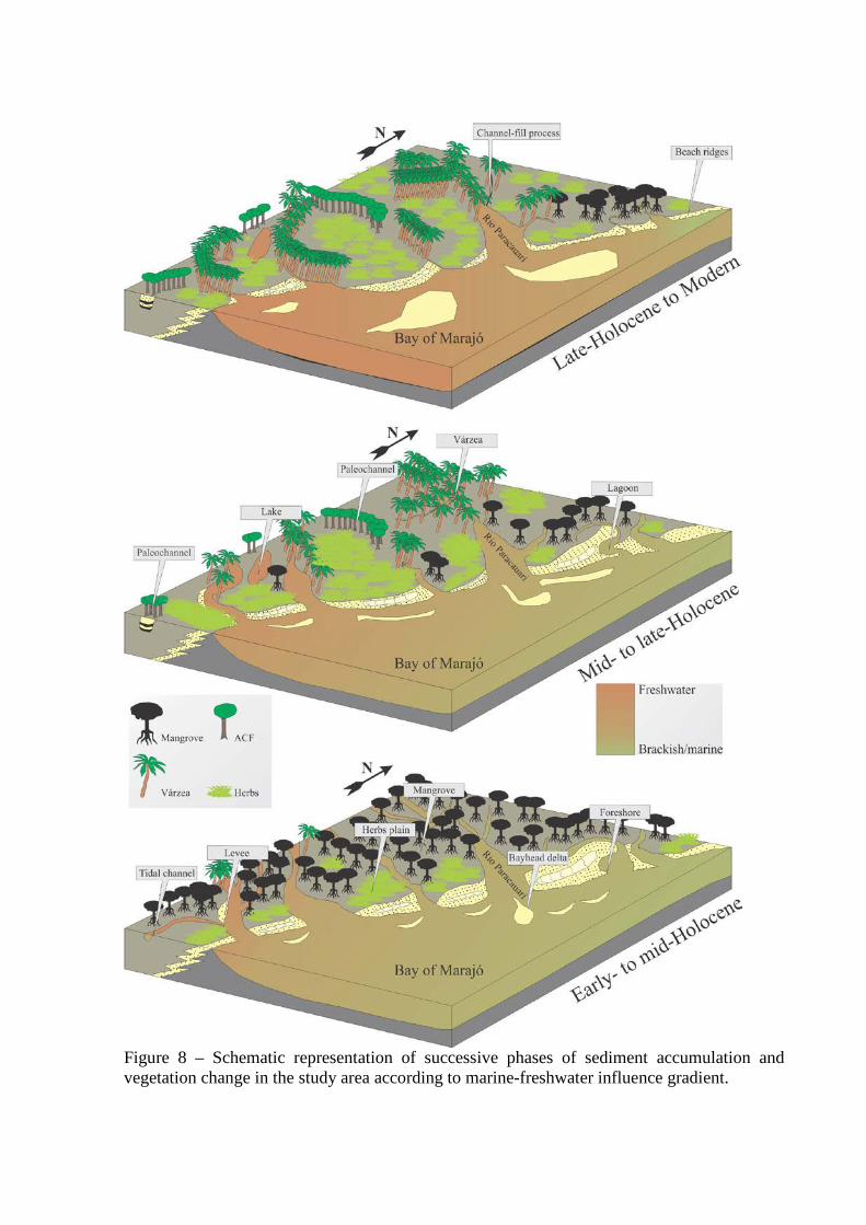
Figure 8 – Schematic representation of successive phases of sediment accumulation and vegetation change in the study area according to marine-freshwater influence gradient.
First phase (Early- to mid-Holocene – mangrove): ~7500 to ~3200 cal yr BP
The tidal mud flats were occupied by mangroves since at least ~7500 cal yr BP, and
remained in the area of R-5 until ~3200 cal yr BP (Figure 8). The relationship between δ13C
and C/N values indicates an influence of estuarine organic matter, with dominance of C3
plants (δ13C= −32‰ to −21‰, Deines, 1980) and a mixture of freshwater algae (δ13C=
−26‰ to −30‰, Schidlowski et al., 1983; Meyers, 1994) with brackish water algae (δ13C=
−22‰ to −25‰, Peterson et al., 1994). The δ13C values (around −27‰) of organic matter
recorded during this phase are 3‰ enriched in relation to δ13C values range of mangrove
vegetation (-33 to -30‰, table 1), with pollen percentage between 60 to 95% and mixture
with some herbs also C3. These isotope values difference may be attributed to the natural
trend of δ13C to increase towards the deeper layers, around 3 to 4‰, caused by the
fractionation during decomposition of organic matter. The δ15N values (1.3 to 5.0‰) suggest
a mixture of terrestrial plants and aquatic organic matter (~5.0‰, Sukigara and Saino, 2005).
The C/N values (15-42) also indicate a mixture of organic matter from vascular plants and
algae (< 10 algae dominance and > 12 vascular plants, Meyers, 1994; Tyson, 1995).
Second phase (Mid- to late-Holocene. – lake): ~3200 to ~1880 cal yr BP
This phase is marked by massive mud sedimentation, with organic matter film
(1mm), and some benthic tubes, root and root marks (R-5, 42 cm) that indicate stagnant
conditions with vegetation development (herbaceous plain and ACF influence). The
relationship between δ13C (−25.5‰ to −22.7‰) and C/N values (< 20) indicate a mixture of
continental organic matter, dominance of C3 plants with a slight C4 plant (herbaceous)
influence and aquatic contribution (Figures 6, 7 and 8), allowing the inference of a lacustrine
environment since ~3200 cal yr BP at the earliest. During this stage a reduction of mangrove
occurs (<8%) that is replaced by herbaceous vegetation (20 to 55%), ACF (30 to 75%) and
some aquatics elements with freshwater influence. The interruption of mangrove development
during this period indicates unfavorable conditions to mangrove development, which may be
due to a decrease in porewater salinity. During this interval, the ACF and herbaceous plain,
which had adapted to freshwater flooding, expanded in this area. The mangroves were
isolated in the most northeastern areas of Marajó Island (about 40 km away from R-5 core),
where the tidal water salinity remained relatively higher.
Third phase (Late Holocene to modern – mangrove): ~1700 cal yr BP to modern
The foreshore facies association (R-4, Figure 5) was recorded between ~1700 and
~600 cal yr BP. This period is marked by low TOC and absence of pollen. It may be caused
by various external factors (sediment grain size, microbial attack, oxidation and mechanical
forces), as well as factors inherent to the pollen grains themselves (sporopollenine content,
chemical and physical composition of the pollen wall) (Havinga, 1967). In this case the
sediment grain size and energy flow can be considered the main cause of the pollen absence,
since the sandy sediments are not favorable to pollen preservation.
During the foreshore facies association, it was not possible to measure the C/N and
δ15N values due to low concentration of nitrogen in sedimentary organic matter. Thus, it is not
possible to identify the origin of organic matter (terrestrial or marine) preserved in these
sediments. The δ13C values (around −26‰) may indicate continental C3 plants (−32‰ to
−21‰, Deines, 1980) and/or freshwater algae (−26‰ to −30‰, Schidlowski et al., 1983;
Meyers, 1994).
This phase is marked by mangrove presence since ~1150 cal yr BP (R-2) at the
earliest, and is recorded in cores R-1, R-4 and R-3 at ~540, ~580 and ~660 cal yr BP,
respectively. Data presented by Behling et al. (2004) shows that mangrove vegetation became
established at about ~2800 cal yr BP along the northeastern Marajó Island. The vegetation
development in this region was marked by four ecological groups (herbs, Restinga, ACF and
palms).
During the last thousand years the relationship between δ13C and C/N shows a trend
from continental organic matter to organic matter originating from estuarine algae during
mangrove establishment (Figure 7). This indicates an increase in tidal influence on the R-1,
R-2, R-3 and R-4 areas, mainly during the last century.
Amazon River and Relative Sea Level (RSL) controlling mangrove dynamics
The Amazon climate change within the Holocene is often offered as a causal
mechanism underlying the modern biodiversity and biogeography of Amazonia (e.g. Bush,
1994; Colinvaux, 1998, Bush et al., 2004; Weng et al., 2004; Hermanowski et al., 2012).
Main climatic factors may have driven changes in vegetation as temperature, precipitation,
seasonality and CO2 concentration (Bush et al., 2004). However, the development of
mangroves is regulated by continent-ocean interactions and their expansion is determined by
the topography relative to sea-level (Gornitz 1991; Cohen and Lara, 2003), and flow energy
(Woodroffe, 1989; Chapman 1976), where mangroves preferentially occupy mud surfaces. On
the mud tidal flats, this ecosystem is controlled by tidal inundation frequency, nutrient
availability, and porewater salinity (Hutchings and Saenger, 1987, Lara and Cohen, 2006).
Mangroves are tolerant to soil salinity and sediment salinity is mostly controlled by flooding
frequency (Cohen and Lara, 2003) and estuarine salinity gradients (Lara and Cohen, 2006).
Therefore, despite that mangroves are influenced by coastal variables (Blasco et al.
1996), climatic changes recorded in Amazon basin during the Holocene (Absy et al., 1991;
Desjardins et al., 1996; Gouveia et al., 1997; Pessenda et al., 1998a) must be affecting the
Amazon River discharge, and consequently, its estuarine salinity gradients and the area
flooded by estuarine waters at the mouth of the Amazon River (Smith et al., 2011; 2012;
Guimarães et al., 2012).
The data indicate a tidal mud flat colonized by mangroves with influence of estuarine
organic matter between at least ~7500 and ~3200 cal yr BP (Figures 7f and 8). Probably it is
due to the relatively higher marine influence favored by reduced Amazon River discharge
caused by a dry period during the early and middle Holocene (Pessenda et al., 2001; Behling
and Hooghiemstra, 2000; Freitas et al., 2001; Sifeddine et al. 2001; Weng et al., 2002; Bush et
al., 2007). Mangrove expansion during the early Holocene was likely caused by the post-
glacial sea-level rise which, combined with tectonic subsidence (Rossetti et al., 2008;
Rossetti, et al., 2012), led to a marine transgression. This event caused a marine incursion
along the littoral of northern Brazil, where the RSL stabilized at its current level between
7000 and 5000 yr BP (e.g. Cohen et al., 2005a; Vedel et al., 2006). A transgressive phase
occurred on Marajó Island in the early to middle Holocene. Subsequently, there was a return
to more continental conditions that prevail currently in the study area (Rossetti et al., 2008).
During the late Holocene, there was a decrease of mangrove vegetation in the area of
R-5 and the contribution of freshwater organic matter is higher than early and middle
Holocene (Figure 7f), suggesting a decrease in marine influence as recorded by Smith et al.
(2012). This led to the isolation of mangroves in the eastern Marajó Island since at least
~1150 cal yr BP (Figure 3), indicating a gradual migration of mangroves from the central
region to the current coastline (Figure 8). An increment in Amazon River discharge during the
more humid late Holocene in the Northern and Northeastern regions of Brazil (Pessenda et
al.,1998a, 2001, 2004, 2010) constitutes a hypothesis for this isolation (Guimarães et al.,
2012; Smith et al., 2011; 2012). This process could be responsible for the modern decrease in
tidal water salinity along the littoral (0–6 ‰, Santos et al., 2008). It is clearly observed in the
relationship between C/N and δ13C (Figure 7), which shows a trend of increasing aquatic
organic matter (R-1, R-2, R-3 and R-4).
Conclusions
The sediment deposits from Marajó Island offer a valuable opportunity to investigate
past climate and RSL, and its effects on vegetation and sedimentary organic matter. Changes
in vegetation, sediment deposition and organic matter input should be related to the
interaction between Amazon climate and the RSL. The data indicate a tidal mud flat colonized
by mangroves with estuarine organic matter in the interior of Marajó Island between ~7500
and ~3200 cal yr BP. It was caused by the post-glacial sea-level rise, which combined with
tectonic subsidence, produced a marine transgression. Likely, the relatively higher marine
influence along the studied area was favored by reduced Amazon River discharge caused by a
dry period during the early and middle Holocene.
During the late Holocene, there was a reduction of mangrove vegetation in the
interior of Marajó Island and the contribution of freshwater organic matter was higher than
during the early and middle Holocene. It suggests a decrease in marine influence that led to a
gradual migration of mangroves from the central region to the northeastern littoral, and
consequently, its isolation since at least ~1150 cal yr BP. These likely results from lower tidal
water salinity caused by a wet period that resulted in greater river discharge during the late
Holocene.
As reported by this work, using a combination of proxies is efficient for establish a
relationship between changes in estuarine salinity gradient and depositional
environment/vegetation.
CHAPTER IV:
LANDSCAPE EVOLUTION DURING THE LATE
QUATERNARY AT THE DOCE RIVER MOUTH, STATE OF
ESPÍRITO SANTO, SOUTHEASTERN BRAZIL
* Paper accepted on Palaeogeography, Palaeoclimatology, Palaeoecology
Abstract
The sedimentary deposits of delta plain of the Doce and Barra Seca Rivers,
Southeastern Brazil, were studied by facies analysis, pollen records, δ13C, C/N analysis and 14C- dating by AMS. Today, this deltaic plain is dominated by beach ridges and sandy terraces
occupied by arboreal and herbaceous vegetation. Between at least ~47,500 and ~29,400 cal yr
B.P., a deltaic system was developed in response mainly to eustatic sea-level fall. Despite of
the stratigraphic sequence studied presents compatibility with the trend of global sea-level
fall, the position of old sea-level, suggested by the deltaic system, is above the expected for
the MIS3 stage. Probably, a tectonic uplift occurred during the late Quaternary and raised this
sedimentary sequence. The post-glacial sea-level rise caused a marine incursion with invasion
of embayed coast and broad valleys, and it favored the evolution of an estuary with wide tidal
mud flats occupied by mangroves between at least ~7400 and ~5100 cal yr B.P. Probably, the
high river sand supply and/or the relative sea-level fall in the late Holocene lead to seaward
and downward translation of the shoreline during normal/forced regression, producing
progradational deposits with mangrove shrink and expansion of marsh colonized by
herbaceous vegetation. Therefore, stratigraphic architecture and evolution of the Doce River
delta plain suggest that fluvial sediment supply and relative sea-level fluctuations related to
Quaternary global climatic changes and tectonism exerted a major control on sedimentation
through the variation of accommodation space and base-level changes.
Keywords: climate change; isotopes; palynology; sea-level changes; sedimentary facies
Introduction
Systematic studies of the Holocene sea-level in the eastern Brazilian coastline show a
post-glacial sea-level rise, and that a middle Holocene sea-level highstand occurred along the
whole coast, with a subsequent fall to the present time (e.g., Angulo et al., 2006). The sea-
level change and the local balance of the coastal sediments are the main factors that control
the evolution of the sedimentary plains in the Brazilian coast. Associated to these plains,
several ecosystems and coastal systems, such as mangroves, beaches, lagoons, and deltas
undergo the influence of those factors and interact among themselves composing an
integrated system that cannot be analyzed in isolation (e.g., Woodroffe, 2002).
Considering a sandy coastal zone with an equilibrium profile determined by the local
hydrodynamics and the grain size of the sediments, the profile is constantly being destroyed
by hydrodynamic changes due to tides, waves and litoraneous currents. However, over a
sufficiently long period of time, a standard equilibrium profile will be established. This
equilibrium may be disturbed by the relative sea-level rise (SLR), but it would be re-
established by a landward displacement of the beach profile. This results in an accelerated
erosion of the beach prism and transfer of eroded sands toward the inner shelf, with the rise of
the inner shelf bottom by a height equal to that of SLR (Bruun, 1962; Schwartz, 1965; 1968;
Woodroffe, 2002).
Under conditions of rising sea-level on a gently sloping sandy coast, a barrier island
with lagoons and/or estuaries are the dominant depositional systems (Swift, 1975), and beach-
ridge plains are virtually absent. Regarding estuaries, its response to sea-level changes is
affected by tidal range, nearshore wave climate, river inflow, and the nature and supply of
sediments. All estuaries assumed their present form during the rise of sea-level that followed
the Last Glacial Maximum (LGM), about 20 thousand years ago (Chappell and Woodroffe,
1994). In contrast, a sea-level fall creates highly unfavorable conditions for the genesis and
maintenance of estuaries, lagoons and bays, especially in wave dominated coasts. The
continued river sediment supply results in shoreline progradation, and it may generate a delta
(Suter, 1994). Lagoons and bays become emergent and beach ridge plains rapidly prograde,
resulting in regressive sand sheets (Martin and Suguio, 1992).
If the littoral is colonized by mangroves, they can be used as indicators of coastal
dynamics, since their position within the intertidal zone are strongly influenced by SLR
(Woodroffe et al., 1989; Woodroffe, 1995). Over a range of SLR scenarios, coastal wetlands
adjust towards an equilibrium with sea-level (e.g., D’Alpaos et al., 2007; Kirwan and Murray,
2007). Equilibrium models predict that coastal wetlands have a number of feedbacks that
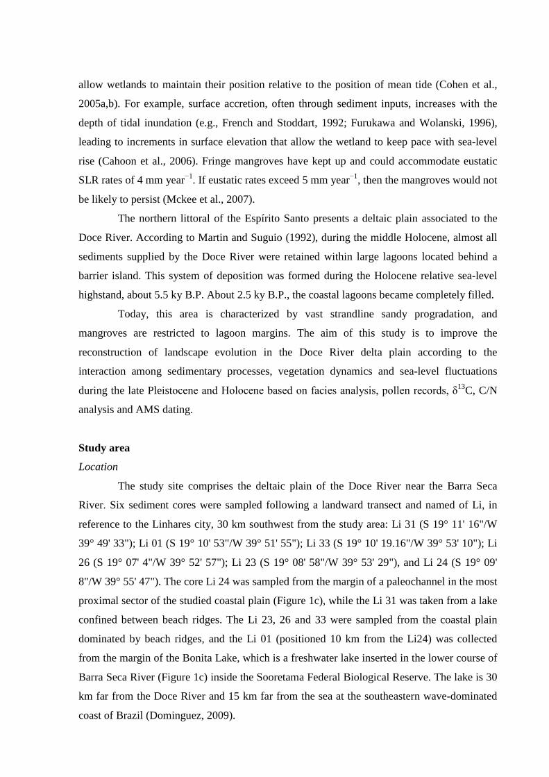
allow wetlands to maintain their position relative to the position of mean tide (Cohen et al.,
2005a,b). For example, surface accretion, often through sediment inputs, increases with the
depth of tidal inundation (e.g., French and Stoddart, 1992; Furukawa and Wolanski, 1996),
leading to increments in surface elevation that allow the wetland to keep pace with sea-level
rise (Cahoon et al., 2006). Fringe mangroves have kept up and could accommodate eustatic
SLR rates of 4 mm year−1. If eustatic rates exceed 5 mm year−1, then the mangroves would not
be likely to persist (Mckee et al., 2007).
The northern littoral of the Espírito Santo presents a deltaic plain associated to the
Doce River. According to Martin and Suguio (1992), during the middle Holocene, almost all
sediments supplied by the Doce River were retained within large lagoons located behind a
barrier island. This system of deposition was formed during the Holocene relative sea-level
highstand, about 5.5 ky B.P. About 2.5 ky B.P., the coastal lagoons became completely filled.
Today, this area is characterized by vast strandline sandy progradation, and
mangroves are restricted to lagoon margins. The aim of this study is to improve the
reconstruction of landscape evolution in the Doce River delta plain according to the
interaction among sedimentary processes, vegetation dynamics and sea-level fluctuations
during the late Pleistocene and Holocene based on facies analysis, pollen records, δ13C, C/N
analysis and AMS dating.
Study area
Location
The study site comprises the deltaic plain of the Doce River near the Barra Seca
River. Six sediment cores were sampled following a landward transect and named of Li, in
reference to the Linhares city, 30 km southwest from the study area: Li 31 (S 19° 11' 16"/W
39° 49' 33"); Li 01 (S 19° 10' 53"/W 39° 51' 55"); Li 33 (S 19° 10' 19.16"/W 39° 53' 10"); Li
26 (S 19° 07' 4"/W 39° 52' 57"); Li 23 (S 19° 08' 58"/W 39° 53' 29"), and Li 24 (S 19° 09'
8"/W 39° 55' 47"). The core Li 24 was sampled from the margin of a paleochannel in the most
proximal sector of the studied coastal plain (Figure 1c), while the Li 31 was taken from a lake
confined between beach ridges. The Li 23, 26 and 33 were sampled from the coastal plain
dominated by beach ridges, and the Li 01 (positioned 10 km from the Li24) was collected
from the margin of the Bonita Lake, which is a freshwater lake inserted in the lower course of
Barra Seca River (Figure 1c) inside the Sooretama Federal Biological Reserve. The lake is 30
km far from the Doce River and 15 km far from the sea at the southeastern wave-dominated
coast of Brazil (Dominguez, 2009).
Figure 1 – a) Location of the study area, and its geological context. b) SRTM-DEM
topography of the study site and lithostratigraphic profiles. C) Location of studied sediment
cores and the spatial distribution of main geomorphological features.
Geology and geomorphology
Four geomorphological units are recognized in the area: (1) the mountainous area,
represented by Precambrian crystalline rocks, with a multidirectional rectangular dendritic
drainage net; (2) a tableland area composed of the Barreiras Formation, which is constituted
by sandstones, conglomerates, and mudstones attributed mainly to Neogene fluvial and
alluvial fan deposits, but possibly including marine deposits originated from a coastal onlap
associated to Neogene transgressions (Arai, 2006; Dominguez, 2009); (3) a coastal plain
area, with fluvial, transitional and shallow marine sediments, which were deposited during
changes in sea-level in the Quaternary (Martin and Suguio, 1992); and (4) an inner continental
shelf area (Asmus et al., 1971). Several W-E, NW–SE and NE–SW tectonic lineaments revel
the importance of regional tectonic in the development of many modern drainage systems
(Fig. 1a).
Currently, the Doce River shows a mostly W-E trending “straight” pattern, flowing
on basement crystalline rocks and into the littoral plain through a low valley with Holocene
terraces (Figure 1). The terraces, with a 0.45% longitudinal gradient, consist of a mixture of
sediments from the Barreiras Formation, and are transported by rivers that originate in
mountainous areas and Neogene tablelands. They are composed mainly of moderately sorted,
coarse- to very-coarse grained sands that are distributed along the coastline forming beach
ridges. Downstream, sandy silt sediments of the Doce River spread over its floodplain (Figure
1). Residual and very poorly preserved mangrove vegetation close to marine influence occurs
in the margin of the barrier and coastal lagoon system. An elongated coastal sand barrier
occurs parallel to the shore and are separated from the mainland by a lagoon. It displays 37
and 3.6 km in length and width, respectively, and present multiple beach ridges, that likely
represent successive shoreline positions formed during coastline progradation associated to
sea-level fall (Otvos, 2000).
The studied delta plain covers an area of ~2700 km2 and displays fluvial channels
and an extensive paleochannel network. The abandoned channels present straight to
meandering patterns, and they maintain the shape and typical concavity of the original
channel, resulting in the formation of lakes and lake belts (Figure 1). Avulsion may have been
responsible for the partial or complete abandonment of several channels due to the rapid sand
sedimentation.
Considering the sandy ridges, they present extensive, straight to slightly curved sand
bodies colonized by herbaceous vegetation, and exhibit N-S and NW-SE orientations,
elevation between 4 and 11 m, 2 to 20 km in length with interridge spacing between 30 and
200 m (Figure 1). Additionally, the studied delta plain presents three topographic groups of
sandy ridges, named inner (~9 m), intermediated (~5 m) and outer sandy ridge (~10 m) with
maximal width of about 3.5; 75 and 3.6 km, respectively. The inner and intermediate sandy
ridges are interpreted as beach ridges, while the outer sandy ridges occur as dune ridges.
Some interridge depressions present standing water. These shallow interridge lakes are
subjected to overbank crevassing, resulting in a sediment influx into the lake. They show ~2
m depth, water salinity of ~0‰, and ephemeral behavior due to the seasonality of climate and
hydrology. The deposits consist of thick peat layers, laminated, mud and bioturbated mud,
which are colonized by freshwater marshes.
Climate
The region is characterized by a warm and humid tropical climate with annual
precipitation averaging 1400 mm (Peixoto and Gentry, 1990), and concentrated in the
summer, between November and January. The dry fall-winter season occurs between May
and September. It is regulated by the position of the Inter Tropical Convergence Zone (ITCZ)
and South Atlantic Convergence Zone (SACZ) (Carvalho et al., 2004). The study area is
entirely located within the South Atlantic trade winds belt (NE-E-SE) that is related to a local
high-pressure cell and the periodic advance of the Atlantic Polar Front during the autumn and
winter, generating SSE winds (Dominguez et al., 1992, Martin et al., 1998). The average
temperature ranges between 20º and 26º C.
Vegetation
The modern vegetation is composed mainly by tropical rainforest. The most
representative plant families are Fabaceae, Myrtaceae, Sapotaceae, Bignoniaceae, Lauraceae,
Hippocrateaceae, Euphorbiaceae, Annonaceae and Apocynaceae (Peixoto and Gentry, 1990).
In the proximal portion of the delta plain occurs a herbaceous plain mainly represented by
Cyperaceae and Poaceae with some trees and shrubs on edge of the plain. A gradual transition
occurs to the distal portion of the delta plain where dominates the restinga vegetation, which
occurs on sand plains and dunes close to the shoreline. It is represented by shrub and herbs.
Palm trees as well as orchids and bromeliads that grow on the trunks and branches of larger
trees occurs also along the shoreline. Ipomoea pes-caprae (Convolvulaceae), Hancornia
speciosa (Apocynaceae), Chrysobalanus icaco (Chrysobalanaceae), Hirtella Americana
(Chrysobalanaceae), Cereus fernambucensis (Cactaceae), Anacardium occidentale
(Anacardiaceae) and Byrsonima crassifolia (Malpighiaceae) are also found. Mangroves
represented by Rhizophora and Avicennia are restricted to the margin of the barrier and
coastal lagoon systems. The vegetation inside the lake and at its margins comprises land
plants such as Tabebuia cassinoides, Alchornea triplinervia and Cecropia sp., and emergent,
submerged, floating-leaved and floating plants like Typha sp., Cyperaceae, Poaceae, Salvinia
sp., Cabomba sp., Utricularia sp. and Tonina sp. A freshwater marsh composed by
herbaceous vegetation colonizes the Barra Seca Valley.
Methods
Remote Sensing
The morphological aspects of the study area were characterized based on the analysis
of Landsat images 5-TM, obtained in August 2008 by INPE-Brazilian National Institute for
Space Research, as well as topographic data acquired during the Shuttle Radar Topographic
Mission (SRTM-90 m) distributed by the National Aeronautics and Space Administration
(NASA). The SRTM data were processed using customized shading schemes and palettes to
highlight topographic and morphological features. We interpreted elevation data using the
software Global Mapper (Global Mapper Software LLC, Olathe, KS, USA).
Sampling processing and facies description
Fieldwork was undertaken in November 2009, during the dry season. Using a
Percussion Drilling (Hammer Cobra TT), the sediment cores were taken up to a depth of 12m.
Following the proposal of Harper (1984) and Walker (1992), facies analysis included
descriptions of lithology, texture and structures. The sedimentary facies were codified
following Miall (1978). The sediment grain size distribution, following Wentworth (1922),
was analyzed by laser diffraction in a Laser Particle Size SHIMADZU SALD 3101.
Pollen and spore analysis
For pollen analyses, 1 cm3 samples were taken at 10 cm intervals along the cores Li
01 and Li24. Preparation followed standard pollen analytical techniques including acetolysis
(Faegri and Iversen, 1989). Pollen and spores were identified by comparison with reference
collections of about 4,000 Brazilian forest taxa and various pollen keys (Salgado-Laboriau,
1973; Absy, 1975; Markgraf and D’Antoni, 1978; Roubik and Moreno, 1991; Colinvaux, et
al., 1999) jointly with the reference collection of the Laboratory of Coastal Dynamics –
Federal University of Pará and 14C Laboratory of the Center for Nuclear Energy in
Agriculture (CENA/USP) to identify pollen grains and spores. A minimum of 300 pollen
grains were counted for each sample. In specific depths 100-200 grains were counted due to
low pollen concentration. Microfossils consisting of spores, algae and some fungal were also
counted, but not included in the sum. Pollen data are presented in pollen diagrams as
percentages of the total pollen sum. Taxa were grouped into broad ecological categories
including mangrove, trees and shrubs, herbs, palms, fern spores, and micro-foraminifer. The
software TILIA was used for calculations, and CONISS and TILIAGRAPH for the cluster
analysis of pollen taxa and to plot the pollen diagrams (Grimm, 1987).
Isotopic and chemical analysis
Ninety-four samples (1 cm3) were collected along the cores Li01 and Li24. Samples
were separated and treated with 4% HCl to eliminate carbonates, washed with distilled water
until pH ~ 6, dried at 50ºC, and homogenized. These samples were used for total organic
carbon (TOC) and total nitrogen (TN) analyses, carried out at the Stable Isotope Laboratory of
the Center for Nuclear Energy in Agriculture (CENA/USP). The results are expressed in
percent of dry weight, with an analytical precision of 0.09 and 0.07%, respectively. The 13C
results are expressed as δ13C with respect to the VPDB standard using the following
conventional notations:
δ13C (‰)=[(R1sample/R2standard)-1] . 1000
where RS1 and RS2 are, respectively, the 13C/12C ratios in the sample, RPDB the 13C/12C ratio
for the international standard (VPDB). The results are expressed in delta per mil (δ ‰)
notation, with analytical precision better than 0.2 ‰ (Pessenda et al., 2004).
Radiocarbon dating
Thirteen samples of ~ 2g each of sedimentary organic matter and one shell were used
for radiocarbon dating (Table 1). The sediment samples were physically treated by removing
roots and vegetal fragments under the microscope. The residual material was then chemically
treated with 2 % HCl at 60°C during 4 hours, washed with distilled water until neutral pH and
dried (50 ºC), in order to remove eventual younger organic fractions (fulvic/humic acids) and
carbonates. A chronologic framework for the sedimentary sequence was provided by
conventional and accelerator mass spectrometer (AMS) radiocarbon dating. Samples were
analyzed at the 14C Laboratory of Fluminense Federal University (LACUFF) and at the
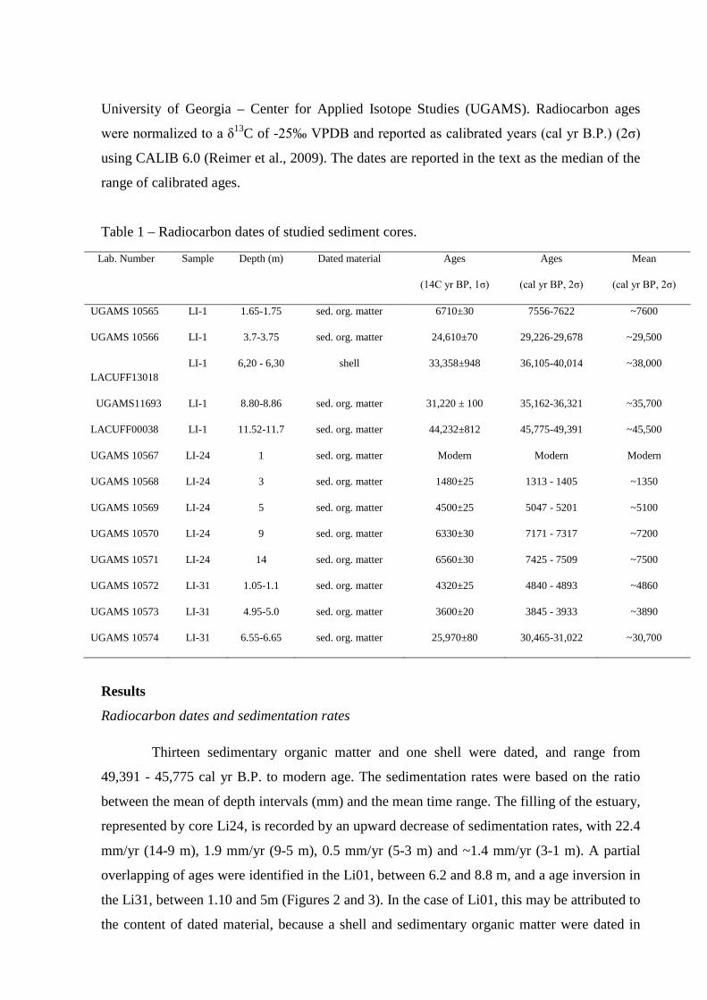
University of Georgia – Center for Applied Isotope Studies (UGAMS). Radiocarbon ages
were normalized to a δ13C of -25‰ VPDB and reported as calibrated years (cal yr B.P.) (2σ)
using CALIB 6.0 (Reimer et al., 2009). The dates are reported in the text as the median of the
range of calibrated ages.
Table 1 – Radiocarbon dates of studied sediment cores.
Lab. Number Sample Depth (m) Dated material Ages
(14C yr BP, 1σ)
Ages
(cal yr BP, 2σ)
Mean
(cal yr BP, 2σ)
UGAMS 10565 LI-1 1.65-1.75 sed. org. matter 6710±30 7556-7622 ~7600
UGAMS 10566 LI-1 3.7-3.75 sed. org. matter 24,610±70 29,226-29,678 ~29,500
LACUFF13018
LI-1 6,20 - 6,30 shell 33,358±948 36,105-40,014 ~38,000
UGAMS11693 LI-1 8.80-8.86 sed. org. matter 31,220 ± 100 35,162-36,321 ~35,700
LACUFF00038 LI-1 11.52-11.7 sed. org. matter 44,232±812 45,775-49,391 ~45,500
UGAMS 10567 LI-24 1 sed. org. matter Modern Modern Modern
UGAMS 10568 LI-24 3 sed. org. matter 1480±25 1313 - 1405 ~1350
UGAMS 10569 LI-24 5 sed. org. matter 4500±25 5047 - 5201 ~5100
UGAMS 10570 LI-24 9 sed. org. matter 6330±30 7171 - 7317 ~7200
UGAMS 10571 LI-24 14 sed. org. matter 6560±30 7425 - 7509 ~7500
UGAMS 10572 LI-31 1.05-1.1 sed. org. matter 4320±25 4840 - 4893 ~4860
UGAMS 10573 LI-31 4.95-5.0 sed. org. matter 3600±20 3845 - 3933 ~3890
UGAMS 10574 LI-31 6.55-6.65 sed. org. matter 25,970±80 30,465-31,022 ~30,700
Results
Radiocarbon dates and sedimentation rates
Thirteen sedimentary organic matter and one shell were dated, and range from
49,391 - 45,775 cal yr B.P. to modern age. The sedimentation rates were based on the ratio
between the mean of depth intervals (mm) and the mean time range. The filling of the estuary,
represented by core Li24, is recorded by an upward decrease of sedimentation rates, with 22.4
mm/yr (14-9 m), 1.9 mm/yr (9-5 m), 0.5 mm/yr (5-3 m) and ~1.4 mm/yr (3-1 m). A partial
overlapping of ages were identified in the Li01, between 6.2 and 8.8 m, and a age inversion in
the Li31, between 1.10 and 5m (Figures 2 and 3). In the case of Li01, this may be attributed to
the content of dated material, because a shell and sedimentary organic matter were dated in
6.20–6.30 and 8.8-8.86 m depth, respectively (Figure 3). Generally, organic matter, found in
marine sediments, are suited for radiocarbon dating, since it is assumed the temporal relation
between the material dated and the timing of sedimentation. However, is possible overgrowth
of calcite in mollusks, and some gastropods incorporate old carbon from limestone or
calcareous sediments into their shells and, therefore, yield radiocarbon ages that are ~3000 14C years too old (Rubin et al., 1963; Evin et al., 1980; Goodfriend, 1987; Goodfriend and
Stipp, 1983; Pigati et al., 2013). Regarding the Li31, the age inversion was recorded in the
base and top of the facies association fluvial channel. This may reflect a rapid filling of the
channel and/or rework of sedimentary organic matter along its pathway (Figure 2).

100
Figure 2 – Topographic correlation among the facies associations identified in the studied cores.

Figure 3 – Stratigraphic description for Li01 with lithological profile, pollen analysis and geochemical variables.
102
Facies description
The studied cores record sedimentary successions encompassing massive sand and
mud, parallel laminated/cross stratified sand and wave laminated/heterolithic lenticular
deposits (Figure 2). Pollen, spore, shell records and δ13C values were added to facies
characteristics in order to define nine facies associations.
Delta plain and Estuary central basin/lagoon-bay (A)
The delta plain deposits occur along the studied cores. They are represented by five
facies associations related to high and low energy proximal environments of the deltaic
system. The sedimentary deposits of the estuary central basin/lagoon-bay occur only in the
base of the Li24.
Facies Association A1- Beach ridge complex
This facies association occurs in the Li01, between 0 and 1.8 m depth; Li23, between
0 and 2.2 m; Li26, between 0 and 5 m, and along the Li33. It is characterized by deposits of
silty to fine-grained sands, with laminated mud and plant remains that grade upward into
sandy deposits with cross-laminated or cross-stratified sand, characterizing coarsening
upward successions, and forming several coarsening upward cycles. In Li33, it consists of
cross-laminated and cross-stratified sands. Association A1 ranges in thickness from a few cm
up to 2 m thick (Figure 2).
Considering the Li01, a pollen assemblage was identified mainly in the finer-grained
layers, and it is predominantly characterized by herbs (30-100%) represented by Poaceae (30-
60%), Cyperaceae (9-40%) and Asteraceae (0-7%); and trees and shrubs, evidenced mainly
by Fabaceae (0-50%) and Sapotaceae (0-17%) pollen.
Facies Association A2- Lake
This facies association occurs only in the Li31 between 0 and 1.2 m in the upper part
of the Facies Association Fluvial Channel. It is characterized by massive mud with plant
remain, being interbedded with a sand level in its basis.
Facies Association A3-Fluvial channel
This association occurs in Li24 (0-1.8 m) and Li31 (1.2-4.6 m). It consists of several
thin fining upward successions of massive, cross-stratified or cross-laminated, fine- to coarse-
grained sands in the Li24 and massive medium to coarse-grained sands in the Li31. These
deposits are typically bounded at the base by sharp and erosional surfaces, which might be
mantled by a lag of quartz granules or mud clasts. The pollen assemblage in the finer-grained
layers in the Li24 presents arboreal (70-86%) pollen as the most representative, followed by
herbaceous (10-15%) pollen (Figure 4). The δ13C values range between -28‰ and -26‰. The
C/N values are between 6 and 12 (Figures 4 and 5).
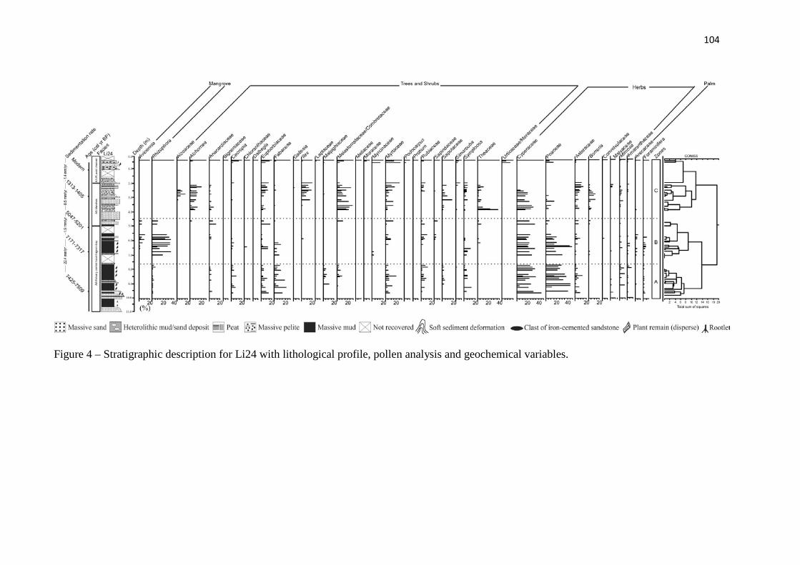
104
Figure 4 – Stratigraphic description for Li24 with lithological profile, pollen analysis and geochemical variables.
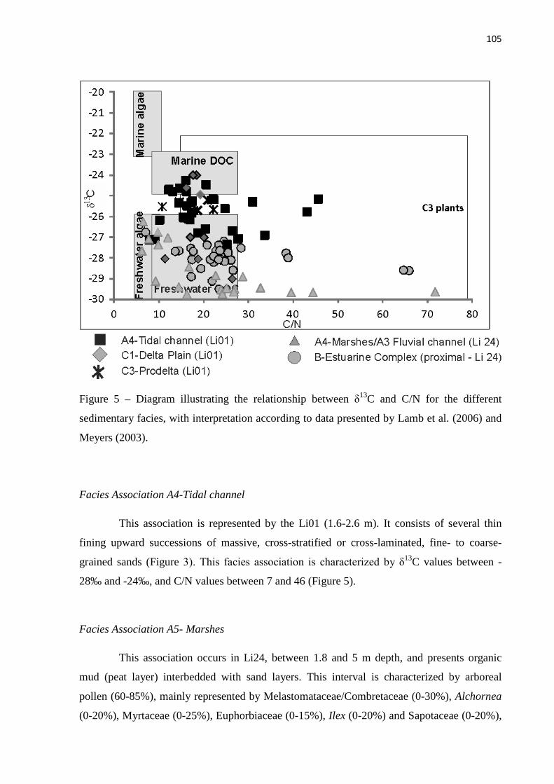
105
Figure 5 – Diagram illustrating the relationship between δ13C and C/N for the different
sedimentary facies, with interpretation according to data presented by Lamb et al. (2006) and
Meyers (2003).
Facies Association A4-Tidal channel
This association is represented by the Li01 (1.6-2.6 m). It consists of several thin
fining upward successions of massive, cross-stratified or cross-laminated, fine- to coarse-
grained sands (Figure 3). This facies association is characterized by δ13C values between -
28‰ and -24‰, and C/N values between 7 and 46 (Figure 5).
Facies Association A5- Marshes
This association occurs in Li24, between 1.8 and 5 m depth, and presents organic
mud (peat layer) interbedded with sand layers. This interval is characterized by arboreal
pollen (60-85%), mainly represented by Melastomataceae/Combretaceae (0-30%), Alchornea
(0-20%), Myrtaceae (0-25%), Euphorbiaceae (0-15%), Ilex (0-20%) and Sapotaceae (0-20%),
followed by herbs pollen (20-60%) mainly composed by Cyperaceae (1-30%), Poaceae (0-
15%), Borreria (0-15%), Aizoaceae (0-20%), Asteraceae (0-15%) and Mimosa (0-5%)
(Figure 4). The δ13C values range between -26‰ and -30‰, and the C/N values occur
between 9 and 71 (Figure 5).
Facies Association A6- Estuary central basin/lagoon-bay
This facies association was recorded in core Li24 between 4.5 and 11 m, represented
by massive mud with plant remain, being interbedded with sand levels deposited during the
early Holocene. This phase is characterized by arboreal and herbaceous pollen (Figure 4). In
contrast to the facies associations from coastal plain, these deposits are dominantly muddy. It
grades upward into tidal flat colonized by mangroves with thickening and coarsening upward
successions. Trees and shrubs (20-45%) and herbs (35-73%) pollen, followed by mangrove
(15-43%) pollen represented by Rhizophora (10-30%) and Avicennia (5-10%), are preserved,
occurring between 4.5 and 7 m in a massive mud with sand. Between 7 and 11 m occurs trees
and shrubs (20-60%) and herbaceous (40-75) pollen (Figure 4). This facies association is
characterized by δ13C values between -29 and -27‰. The C/N values display a range of
variation between 8 and 66 (Figure 5).
Deltaic system (B)
This depositional system is recorded between 5 and 7 m in the Li31 (Figure 2) and
3.4 and 12 m depth in the Li01 (Figure 3). It is represented by three facies associations: B1-
Delta Plain, B2-Deltafront and B3-Prodelta.
Facies Association B1-Delta Plain
It is mainly characterized by gray massive and laminated mud with massive sandy
levels between 7 and 5 m in the Li31 (Figure 2), and between 3.6 and 5.0 m in Li01 (Figure
3). The pollen assemblages in this interval in the Li01 is characterized by the predominance of
herbs pollen (35-96%) represented by Poaceae (36-96%), Cyperaceae (0-8%), Asteraceae (0-
5%), Mimosa (0-5%), Borreria (0-5%) and Amaranthaceae (0-5%). The trees and shrubs are
represented mainly by Fabaceae (0-28%), Anacardiaceae (0-14%), Malpighiaceae (0-12%),
Byrsonima (0-5%), Rubiaceae (0-18%) and Myrtaceae (0-5%). The mangrove is characterized
by Rhizophora (5-32%). Arecaceae and ferns occurred also during this phase (Figure 3). This
facies association is characterized by δ13C values between -26 and -25‰. The C/N values
display a range of variation between 11 and 23 (Figure 5).
Facies Association B2-Delta Front
This facies association was record along the 5-8 m and 9.2-12 m intervals in the Li01
(Figure 3). Between 5-7.5 m, it presents a dark silt to medium-grained quartz sand, and
contains shells (Olivella mutica, Glycymeris sp., Halistylus columna, Corbula cymellain,
Mulinia cleryana, Tivela sp., Strigilla mirabilis and Miltha childrenae) that may be scattered
within the sediment or concentrated in layers. These species are found in sandy-muddy
sediments from coastal areas near the mouths of rivers or oceanic islands (Da Costa, 1778;
Say, 1822; Dall, 1881; Dall, 1890). The Mulinia cleryana may be found in coastal regions,
between 0 to 30 m (Orbigny, 1846). The Tivela sp. occurs between 0 and 20 m (Link, 1807).
Olivella mutica is found up to 113 m (Say, 1822). The Halistylus columna occurs between 18
and 108 m (Dall, 1890), while the Strigilla mirabilis and Miltha childrenae may be found
between 10 and 65 m depth (Gray, 1825; Orbigny, 1841; Philippi, 1841).
The 7.5-8 m and 9.2-12 m intervals present characteristics of deltafront and prodelta
with massive sand and dark clay level. These intervals contain shells (Anachis isabellei,
Natica sp., Olivella floralia, Anadara ovalis) scattered in the sediment. These species are
found in sandy-muddy sediments from coastal areas near the mouths of rivers or oceanic
islands (Bruguière, 1789; Orbigny, 1841; Duclos, 1840), while the Anadara ovalis may be
found in coastal waters associated with carbonate and coral reefs (Bruguière, 1789).
Facies Association B3-Prodelta
It occurs between 8 and 9.2 m, and is represented by massive dark clay. Shells are
present along this interval, however, due to its poor preservation, we could not identify them.
This facies association is characterized by δ13C values between -25 and -23‰. The C/N
values display a range of variation between 13 and 19 (Figure 5).
Palaeoenvironmental Interpretation
Likely, the base of the Li01 (12-9.2m) characterizes a transition zone between delta
front and prodelta accumulated between ~47,500 and ~35,000 cal yr B.P., while the upward
succession deposited in 9.2-8 and 8-7.5 m intervals were accumulated in a prodelta and
prodelta/delta front environment, respectively (Figure 6). The prodelta is entirely subaqueous
and presents the finest-grained portion of a delta. Sediments here are deposited mostly from
suspension, or from dilute turbidity currents flows. The finest sediments are found at the
greatest depths, and usually a coarsening-upward signature is present. Relatively slow or
intermittent deposition can permit marine organisms to colonize the sediments of the prodelta
(Suter, 1994).
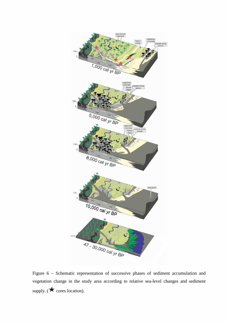
Figure 6 – Schematic representation of successive phases of sediment accumulation and
vegetation change in the study area according to relative sea-level changes and sediment
supply. ( cores location).
Probably, the sediments accumulated between 7.5 and 5 m record a delta front that is
the transition zone from the fluvial to the marine environment. The delta front includes distal
bar silts, distributary mouth bar sands, and redistributed marine deposits such as tidal ridges
and shoreface deposits. The process of river mouth sedimentation and seaward fining of
sediments results in the deposition of the coarsest material in a short distance from the river
mouth, on the upper parts of the delta front (Suter, 1994). The sedimentary deposits between
5 and 3.6 m should represent a delta plain with its tidal flats, lagoons, mangroves and creeks
(Suter, 1994; Figures 3 and 6). The deltaic sediments, accumulated between ~47,500 and
~29,000, presents δ13C values, ranging between -26‰ and -23‰, and C/N values between 11
and 23 (Fig. 5), indicating continental organic matter (C3 plants) and freshwater/marine algae
influence (-30‰ to -26‰ and -23‰ to -16‰, respectively, Schidlowski et al., 1983; Meyers,
1994).
Regarding the facies association A6 (Estuary central basin/lagoon-bay) accumulated
during the early and middle Holocene (Figure 4), it presents low flow energy, likely in a
depositional environment characterized by shallower water protected from direct wave action.
However, it is subjected to some currents, as indicated by the presence of lenticular
heterolithic mud deposits with sand levels and locally cross laminated sand. The C/N between
8 and 66, and δ13C values, ranging between -29‰ and -27‰ (Figure 5) indicate continental
organic matter (C3 plants) and freshwater algae influence (Figure 5) (Schidlowski et al., 1983;
Meyers, 1994), reveling a proximal portion developed in an estuary, and in particular in the
central portion of the estuary where the low-energy part occurs (Figure 6). Within an estuary,
sediment is coarsest within the marine- and river-dominated zones, and finest in the central
zone (Dalrymple et al., 1992). However, the formation of barrier islands during the early
Holocene may have contributed to the deposition of this sedimentary deposit, as described by
Martin et al. (2003) and França et al. (2013). Then, the facies association A6 may have been
deposited in an estuary central basin or in a lagoon-bay influenced by river with its edge
colonized by mangroves and herbaceous vegetation passing upward into marshes of the
association A4 (Figures 3 and 6).
Today some mangroves occur immediately behind the coastal sandy barriers, which
it favor the lagoons development. Its tidal inlets undergo a longshore migration, and the inlet
channel is often obliterated as the sands from the adjacent barriers migrate.
The facies associations A1, A2, A3, A4 and A5 are compatible with a delta plain
setting, since the studied area today presents several sandy ridges sequence and displays
fluvial channels, lake belts and an extensive paleochannel network (Figure 1).
The association A4 in the Li01 (Figure 3) may correspond to a tidal channel
established during the early Holocene, and represent the distal portion of the delta plain,
relatively more influenced by marine organic matter, as evidenced by the relationship δ13C
and C/N values (Figures 5 and 6). The sandy deposits occur in the tidal channels that run
along the length of the estuary (Woodroffe et al., 1989; Dalrymple et al., 1990). Nevertheless,
the energy minimum is the site of the finest channel sands. Muddy sediments accumulate
primarily in tidal flats and marshes along the sides of the estuary. Then, the facies association
A4 is related to marshes (A5) and estuary central basin/lagoon-bay (A6).
The succession A4-A2 in the Li31 likely evidence abandonment phases of a channel
by avulsion during the middle Holocene. The concavity of the some abandoned channel,
product of avulsion process, may result in formation of lakes (Figures 1 and 2).
The facies association A1 is related to beach ridge complex based on the sandy
nature and coarsening upward nature and on the relationship with the other coastal
associations. The wave-deposited deposits run parallel to a shoreline, and, generally,
inasmuch the relative sea-level fall, the interridges depressions form shallow lakes subjected
to overbank crevassing, resulting in an influx of sediment into the lake ending with its
siltation as identified in facies association A1 (Figure 2, Li23).
Regarding the pollen, isotopic and C/N data, the sequence of facies association A
presents δ13C values predominantly around -28‰ (Li24, Figure 5) and -26‰ (Li01, Figure 5).
The C/N values oscillate between 6 and 72 in the Li24, while in the Li01 presents values
between 10 and 45. These values indicate contribution of C3 plants along the facies
association A3 and A4, as evidenced by the pollen analysis (Figure 5).
Climate and sea-level changes during the late Quaternary
Globally, the climates during the Marine Isotope Stage 3 (MIS3, Figure 7), the phase
that precedes the LGM, are 2oC warmer than LGM (van Meerbeeck et al., 2008), and in the
South America, paleoecology studies indicate that the climate was colder (4 - 5°C lower
compared to modern) during the MIS3 (e.g. Colinvaux et al., 2000; Urrego et al., 2005;
Whitney et al., 2011).
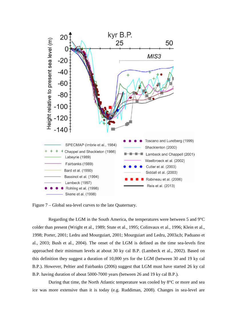
Figure 7 – Global sea-level curves to the late Quaternary.
Regarding the LGM in the South America, the temperatures were between 5 and 9°C
colder than present (Wright et al., 1989; Stute et al., 1995; Colinvaux et al., 1996; Klein et al.,
1998; Porter, 2001; Ledru and Mourguiart, 2001; Mourguiart and Ledru, 2003a;b; Paduano et
al., 2003; Bush et al., 2004). The onset of the LGM is defined as the time sea-levels first
approached their minimum levels at about 30 ky cal B.P. (Lambeck et al., 2002). Based on
this definition they suggest a duration of 10,000 yrs for the LGM (between 30 and 19 ky cal
B.P.). However, Peltier and Fairbanks (2006) suggest that LGM must have started 26 ky cal
B.P. having duration of about 5000-7000 years (between 26 and 19 ky cal B.P.).
During that time, the North Atlantic temperature was cooled by 8°C or more and sea
ice was more extensive than it is today (e.g. Ruddiman, 2008). Changes in sea-level are
directly related to changes in global ice volume, where with each 1-m rise of sea-level
equivalent to 0.4 million km3 of ice (Ruddiman, 2008). According to global sea-level data
based on independent proxies and modelled reconstruction (Figure 7), the global sea-level in
50 ky cal B.P. was between 40 and 80 m below the present, and the sea-level fell gradually
until 30 – 25 ky cal B.P., when the it dropped abruptly (100 – 140 m below the modern sea-
level) until ~20 ky cal B.P. After the end of the LGM the global sea-level rose dramatically
fast (e.g. Fairbanks, 1989; Bard et al., 1990, 1996; Lambeck and Bard, 2000; Lambeck et al.,
2002, 2004; Berné et al., 2007; Clark, 2009; Bard et al., 2010; Bard, 2012). Based on
geomorphic indicators, similar trend was recorded along the continental shelf of Rio de
Janeiro State (Reis et al., 2013).
Considering the present work, the observed succession of facies association B and A
might be a product of driving forces regulated by cyclic mechanism leading to a delta, estuary
and following to a delta plain environment. Probably, the changes in this depositional
environment were driven by the equilibrium between the relative sea-level changes and
fluvial sediment supply during the late Pleistocene and Holocene. Probably, this depositional
architecture of the late Pleistocene coastal system evolving from a prodelta to a delta front,
followed by the delta plain in response to relative sea-level fall between ~47,500 and ~29,400
cal yr B.P. (Figures 6 and 7).
The sediments accumulated during the LGM and the late Pleistocene/Holocene
transition were not characterized. Probably, from ~ 29,400 cal yr B.P. to ~7500 cal yr B.P in
Li01, and ~30,000 cal yr B.P. to ~3900 cal yr B.P. in Li31, a sedimentary hiatus occurred,
related to an erosive event associated to the rapid post glacial sea-level rise. Similar erosive
event between ~ 19,000 cal yr B.P. and ~2200 cal yr B.P. has been recorded at the Cardoso
Island, southern coastal region of São Paulo State, southeastern Brazil (Pessenda at al., 2012).
Although the stratigraphic sequence studied present compatibility with the trends of
global sea-level changes, the position of the old sea-level, suggested by sedimentary deposits
interpreted as a deltaic system, is at least 20 meters above the sea-level of the MIS3 stage. A
tectonic uplift in the study area during the late Quaternary may justify this difference in the
paleo sea-levels, since the late Pleistocene marine terrace deposits in northeastern
Brazil suggests that the littoral zone may have been uplifted by at least 10 – 12 m since 120
ky B.P. (Barreto et al., 2002). In addition, regressive–transgressive events recorded along the
Brazilian coast likely responded to a combination of eustatic sea-level fluctuations and local
factors such as tectonic activity (Rossetti et al., 2013). It may contribute to accumulation of
old marine deposits close to the modern coastline (Rossetti et al., 2011), as recorded in the
Li01 with marine/brackish organic matter, marine shells and mangrove pollen along the
deltaic system (Figure 3).
Regarding the estuary with mangroves recorded in the Li24, it was formed during the
high relative sea-level of the Holocene. Likely, these environments were formed during the
early and middle Holocene as a response of an eustatic sea-level rise that resulted in
significant changes in the coastal geomorphology (Figure 6). During the early Holocene, the
arboreal and herbaceous vegetation dominated the coastal plain, and the equilibrium between
the relative sea-level and fluvial sediment supply created conditions to the development of an
estuarine system with fluvial and tidal channels, and tidal flats colonized by mangroves
(Figure 6).
The upward succession composed by the transition estuarine complex with mangrove
into the coastal plain colonized by marshes in the Li24 suggests a decrease of marine
influence and form the regressive part of the cycle after the post glacial sea-level rise. Thus,
the upper sequence of the Li24 (A5 and A3) should have been accumulated following a
relative sea-level fall or a high fluvial sediment supply during the middle and late Holocene.
Considering the increase in the sand input by fluvial channels, the fluvial sediment was
reworked by wave and caused the sandy ridges with replacement of mangroves by the groups
of trees/shrubs and herbaceous vegetation according to a marine regression.
Sea-level changes and fluvial sediment supply
According to Posamentier et al. (1992), the term "regression" describes a retreat of
the sea and a concomitant seaward expansion of the land. Regression can occur in two
specific ways: (1) if sediment flux delivered to the shoreline exceeds the amount of space
added for sediment to fill; and (2) if there is a relative sea-level fall. In either case, the
shoreline migrates seaward. In the situation 1, sufficient sediment is entering into the coastal
system so as to overwhelm the amount of space available. This can occur during stillstands or
rises of relative sea-level (which is a function of sea surface movement, i.e., eustasy and sea
floor movement, the latter due to tectonics, thermal cooling, loading by sediments or by
water, and sediment compaction) and is referred to as a "normal" regression. However, in
certain cases, regression may not occur despite high volumes of sediment flux, if the
dispersive energy of the littoral environmental (i.e., waves or tidal currents) is high. Under
these circumstances, supplied sediment is distributed over a widespread area commonly
beyond the immediate area, thus preventing progradation of the shoreline.
When no sediment is delivered to the shoreline during a relative sea-level fall, the
regression is said to be forced because a seaward shift of the shoreline must occur, even if the
volume of sediment supplied is zero. This is in marked contrast to "normal" regression, which
occur in response to the balance between variations of sediment flux and new space added
(Posamentier et al., 1992).
In the first situation, regression can occur under conditions of eustatic sea-level rise,
since the rate of sediment flux is greater than the rate of increase of accommodation.
Consequently, in areas of relatively high sediment flux, such as deltas, regression will
continue longer following a sea-level rise, than in areas of relatively low sediment flux. Thus,
despite of the eustatic sea-level rise recorded to the southeastern Brazilian littoral during the
early and middle Holocene, followed by a relative sea-level fall (e.g., Suguio et al., 1985;
Angulo et al., 2006), the high sediment flux of the Doce and Barra Seca River may have
contributed to the regressive sequence since the middle Holocene.
Conclusion
Between at least ~47,500 and ~29,400 cal yr B.P., a deltaic system was developed in
response mainly to eustatic sea-level fall of the MIS3 stage. Even though the stratigraphic
sequence studied presents compatibility with the trend of global sea-level fall, the position of
old sea-level, suggested by the deltaic system, is above the sea-level for the MIS3 stage.
Probably, a tectonic uplift occurred during the late Quaternary and raised this sedimentary
succession. The rapid post glacial sea-level rise caused the erosion of the sedimentary
sequences accumulated during the LGM and the late Pleistocene/Holocene transition in the
studied area. This eustatic sea-level rise produced a marine incursion with invasion of
embayed coast and broad valleys, and favored the evolution of an estuary with wide tidal mud
flats occupied by mangroves between at least ~7400 and ~5100 cal yr B.P. During the late
Holocene, the high river sand supply and/or the relative sea-level fall lead to seaward and
downward translation of the shoreline during normal/forced regression, producing
progradational deposits with mangrove shrink and expansion of marsh colonized by
herbaceous vegetation.
Therefore, the case study of the delta plain of Doce River illustrates a stratigraphic
sequence with development of deltaic systems and estuary produced by the interplay of
eustatic sea-level fluctuations and local factors such as sediment supply and tectonic activity.
CHAPTER V:
MANGROVE VEGETATION CHANGES ON HOLOCENE
TERRACES OF THE DOCE RIVER, SOUTHEASTERN
BRAZIL
* Paper published on Catena 110 (2013) 59-69 http://www.sciencedirect.com/science/article/pii/S0341816213001501
Abstract
High-resolution sedimentological, geochemical and pollen analysis on sediment core
from the coastal plain of the Doce River, southeastern Brazil, revealed changes in the
depositional system and vegetation caused by combined action of oscillations in relative sea-
level (RSL) and sedimentary supply during the Holocene. Two main phases were discerned
using sedimentary features, δ13C, δ15N, total organic carbon (TOC), total nitrogen (N), C/N
and cluster analysis of pollen data, temporally synchronized with radiocarbon age dating. The
data indicates the presence of a lagoon system surrounded by a tidal plain colonized by
mangroves and its sedimentary organic matter sourced from C4 plants between ~8050 and
~7115 cal yr BP. However, during the mid and late-Holocene the mangroves shrank and
freshwater vegetation expanded (C3 plants), probably, due to a marine regression. During this
phase, the development of a lacustrine environment was followed by the colonization of
herbs, trees and shrubs. The continuous sediment infilling into the lake allowed the expansion
of a herbaceous plain as seen today. This geomorphologic and vegetation evolution is in
agreement with the mid-Holocene RSL maximum above present RSL and subsequent fall to
the present time.
Keywords: facies analyses, Holocene, mangrove, palynology, sea-level, stable isotopes

Introduction
Several studies have presented coastal environmental shifts in response to Holocene
sea-level changes (Woodroffe, 1981; Parkinson et al., 1994; Blasco et al., 1996; Fujimoto et
al., 1996; Behling et al., 2001, 2004; Yulianto et al., 2004, 2005; Cohen et al., 2005a,b;
Ellison, 2005; Horton et al., 2005; Engelhart et al., 2007; Monacci et al., 2009, 2011;
Guimarães et al., 2012; 2013; Smith et al., 2012; Cohen et al., 2012). The effect of relative
sea-level (RSL) changes is apparent in coastal environments, where significant
geomorphological changes (Giannini et al., 2007) extend to the mangrove dynamics (Behling
et al., 2001, 2004; Lara et al., 2002; Cohen and Lara, 2003; Cohen et al., 2004; 2005a,b;
Vedel et al., 2006; França et al., 2012; Guimarães et al., 2012; Smith et al., 2012). The
expansion or contraction of mangrove areas is dependent on temperature, soil type, salinity,
inundation frequency, sediment accretion, tidal and wave energy (Lugo and Snedaker, 1974).
Specifically the mangrove has special physiological and morphological adaptations that allow
it to grow in intertidal environments (Blasco et al., 1996; Cahoon and Lynch, 1997; Alongi,
2008; Sanders et al., 2012). Thus this ecosystem may be used as indicator of coastal change
and RSL fluctuations (Blasco et al., 1996).
Along the Brazilian coast, mangroves are found from the extreme northern Brazilian
coast in the Oiapoque River (04°20′N) to Laguna (28°30′S) in the southern coast (Schaeffer-
Novelli et al., 2000). In northern Brazil the mangroves are extremely irregular and jagged,
occurring throughout bays and estuaries (Souza-Filho et al., 2006), with meso- and macrotidal
ranges (tidal range of 2 to 4 m and 4 to 6 m, respectively). On the southeastern and southern
coast, mangroves are restricted to microtidal (tidal range below 2 m) bays, lagoons or
estuarine inlets (Schaeffer-Novelli, 1990), which are strongly controlled by climate and
oceanographic characteristics (Soares et al., 2012).
Some studies have shown post-glacial sea-level rise at the Brazilian littoral
(Bittencourt et al., 1979; Suguio et al., 1985; Angulo and Suguio, 1995; Martin et al., 1996;
Angulo and Lessa, 1997; Angulo et al., 1999; Bezerra et al., 2003; Martin et al., 2003; Angulo
et al., 2006), which inundated inland valleys (Martin et al., 1996; Scheel-Ybert, 2000; Cohen
et al., 2005a,b; Souza-Filho et al., 2006), causing changes in depositional systems and also in
mangrove area (Scheel-Ybert, 2000; Cohen et al., 2005a,b; Amaral et al., 2006, 2012; Smith
et al., 2012; Guimarães et al., 2012).
Investigations in northern Brazil utilizing sedimentological, palynological and
geochemical data revealed displacement of the mangrove ecosystem during the Holocene.
This shift is attributed to climate, river discharge and RSL changes (Behling et al., 2004;
Cohen et al., 2005a, 2008, 2009; Lara and Cohen, 2009; Smith et al., 2011, 2012; Guimarães
at al., 2012; França et al., 2012). However, in southeastern Brazil, the mangrove dynamics are
mainly related to RSL changes (Buso Junior, 2010; Buso Junior et al., 2013 – in press) and
sediment transport (Amaral et al., 2006).
For the southeastern Brazilian coast environmental reconstructions based on inter-
proxy analysis are still scarce, and the response of mangrove ecosystems to Holocene sea-
level changes remains poorly understood. In this work we present a study about mangrove
development on the coastal plain of the Doce river, State of Espírito Santo, southeastern
Brazil, during the Holocene, recorded by multiple proxies such as sedimentary features, δ13C
and δ15N, C/N , pollen data and radiocarbon dating.
Modern settings
Study area and geological setting
The study site is located in the coastal plain between two large rivers (Figure 1),
Doce and São Mateus, northern Espírito Santo – Brazil, running along a nearly N-S section
between Conceição da Barra and Barra do Riacho (Suguio et al., 1982; Bittencourt et al.,
2007). The Holocene sedimentary history in this sector is strongly controlled by RSL changes,
fluvial supply and longshore transport. The formation of a barrier island/lagoonal system
began about 7000 yr BP (Suguio et al., 1982; Martin et al., 1996; Martin et al., 2003).
The study area is composed of a Miocene age plateau of Barreiras Formation
continental deposits, whose surface is slightly sloping to the ocean. The site is characterized
by the presence of many wide valleys with flat bottoms, resulting from Quaternary deposition
of silty sediments (Martin et al., 1996). The study area is part of a larger area of tectonically
stable Precambrian crystalline rocks. Four geomorphological units are recognized in the area:
(1) a mountainous province, made up of Precambrian rocks, with a multidirectional
rectangular dendritic drainage net; (2) a tableland area composed of Barreiras Formation
constituted by sandstones, conglomerates and mudstones attributed mainly to Neogene fluvial
and alluvial fan deposits, but possibly including deposits originating from a coastal overlap
associated with Neogene marine transgressions (Arai, 2006; Dominguez et al., 2009). The
drainage catchment slopes gently down towards the sea; and (3) a coastal plain area, with
fluvial, transitional and shallow marine sediments, which were deposited during RSL changes
(Martin and Suguio 1992) and (4) an inner continental shelf area (Asmus et al., 1971).

Figure 1 – Location of the study area: a) Miocene Barreiras Formation and coastal plain of the Doce River; b) RGB Landsat composition – SRTM, with a topographical profile obtained from SRTM digital elevation data illustrating a large area slightly more depressed on coastal plain of the Doce River. Note a morphometric profile along the main geological features and morphological units (a-a’); c) palaeodrainage networks preserved, with lagoons and lake system originated at the Holocene. Note the presence of Pleistocene deposits. Observe also, the beach ridges which are related to coastal progradation.
Climate
The region is characterized by a warm and humid tropical climate with annual
precipitation averaging 1400 mm (Peixoto and Gentry, 1990). Precipitation generally occurs
in the summer with a dry fall-winter season, controlled by the position of the Inter Tropical
Convergence Zone (ITCZ) and the position of the South Atlantic Convergence Zone (SACZ)
(Carvalho et al., 2004). The area is entirely located within the South Atlantic trade winds belt
(NE-E-SE) that is related to a local high-pressure cell and the periodic advance of the Atlantic
Polar Front during the autumn and winter, generating SSE winds (Dominguez et al., 1992,
Martin et al., 1998). The rainy season occurs between the months of November and January
with a drier period between May and September. The average temperature ranges between 20º
and 26º C.
Vegetation
The region is composed mainly of tropical rainforest, where the most representative
plant families are Annonaceae, Fabaceae, Myrtaceae, Sapotaceae, Bignoniaceae, Lauraceae,
Hippocrateaceae, Euphorbiaceae, and Apocynaceae (Peixoto and Gentry, 1990). In the sandy
coastal plain, vegetation is characterized by palm trees as well as orchids and bromeliads that
grow on the trunks and branches of larger trees. Ipomoea pes-caprae, Hancornia speciosa,
Chrysobalanus icaco, Hirtella Americana and Cereus fernambucensis are also found. The
coastal plain of the Doce River is characterized by forest pioneering freshwater species such
as Hypolytrum sp., Panicum sp and also brackish/marine water species such as Polygala
cyparissias, Remiria maritima, Typha sp., Cyperus sp., Montrichardia sp., Tapirira
guianensis and Symphonia globulifera. A mangrove dominated ecosystem is also present,
characterized by Rhizophora mangle, Laguncularia racemosa and Avicennia germinans,
which are currently restricted to the northern littoral part of the coastal plain (Bernini et al.,
2006). Herbaceous vegetation dominates the sampling site, represented by Araceae,
Cyperaceae and Poaceae with some trees and shrubs on edge of the plain (Figure 2).
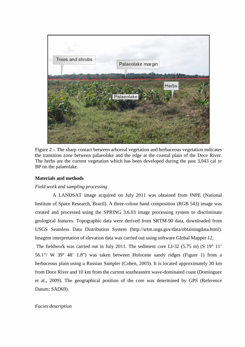
Figure 2 – The sharp contact between arboreal vegetation and herbaceous vegetation indicates the transition zone between palaeolake and the edge at the coastal plain of the Doce River. The herbs are the current vegetation which has been developed during the past 3,043 cal yr BP on the palaeolake. Materials and methods
Field work and sampling processing
A LANDSAT image acquired on July 2011 was obtained from INPE (National
Institute of Space Research, Brazil). A three-colour band composition (RGB 543) image was
created and processed using the SPRING 3.6.03 image processing system to discriminate
geological features. Topographic data were derived from SRTM-90 data, downloaded from
USGS Seamless Data Distribution System (http://srtm.usgs.gov/data/obtainingdata.html).
Imagem interpretation of elevation data was carried out using software Global Mapper 12.
The fieldwork was carried out in July 2011. The sediment core LI-32 (5.75 m) (S 19° 11’
56.1”/ W 39° 48’ 1.8”) was taken between Holocene sandy ridges (Figure 1) from a
herbaceous plain using a Russian Sampler (Cohen, 2003). It is located approximately 30 km
from Doce River and 10 km from the current southeastern wave-dominated coast (Dominguez
et al., 2009). The geographical position of the core was determined by GPS (Reference
Datum: SAD69).
Facies description
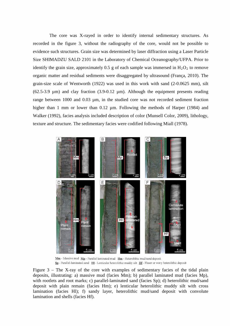
The core was X-rayed in order to identify internal sedimentary structures. As
recorded in the figure 3, without the radiography of the core, would not be possible to
evidence such structures. Grain size was determined by laser diffraction using a Laser Particle
Size SHIMADZU SALD 2101 in the Laboratory of Chemical Oceanography/UFPA. Prior to
identify the grain size, approximately 0.5 g of each sample was immersed in H2O2 to remove
organic matter and residual sediments were disaggregated by ultrasound (França, 2010). The
grain-size scale of Wentworth (1922) was used in this work with sand (2-0.0625 mm), silt
(62.5-3.9 µm) and clay fraction (3.9-0.12 µm). Although the equipment presents reading
range between 1000 and 0.03 µm, in the studied core was not recorded sediment fraction
higher than 1 mm or lower than 0.12 µm. Following the methods of Harper (1984) and
Walker (1992), facies analysis included description of color (Munsell Color, 2009), lithology,
texture and structure. The sedimentary facies were codified following Miall (1978).
Figure 3 – The X-ray of the core with examples of sedimentary facies of the tidal plain deposits, illustrating: a) massive mud (facies Mm); b) parallel laminated mud (facies Mp), with rootlets and root marks; c) parallel-laminated sand (facies Sp); d) heterolithic mud/sand deposit with plain remain (facies Hm); e) lenticular heterolithic muddy silt with cross lamination (facies Hl); f) sandy layer, heterolithic mud/sand deposit with convolute lamination and shells (facies Hf).
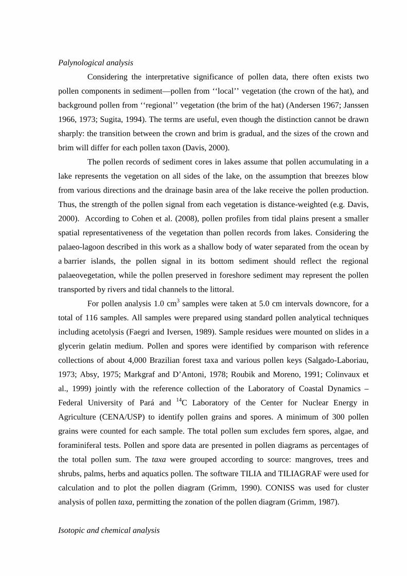
Palynological analysis
Considering the interpretative significance of pollen data, there often exists two
pollen components in sediment—pollen from ‘‘local’’ vegetation (the crown of the hat), and
background pollen from ‘‘regional’’ vegetation (the brim of the hat) (Andersen 1967; Janssen
1966, 1973; Sugita, 1994). The terms are useful, even though the distinction cannot be drawn
sharply: the transition between the crown and brim is gradual, and the sizes of the crown and
brim will differ for each pollen taxon (Davis, 2000).
The pollen records of sediment cores in lakes assume that pollen accumulating in a
lake represents the vegetation on all sides of the lake, on the assumption that breezes blow
from various directions and the drainage basin area of the lake receive the pollen production.
Thus, the strength of the pollen signal from each vegetation is distance-weighted (e.g. Davis,
2000). According to Cohen et al. (2008), pollen profiles from tidal plains present a smaller
spatial representativeness of the vegetation than pollen records from lakes. Considering the
palaeo-lagoon described in this work as a shallow body of water separated from the ocean by
a barrier islands, the pollen signal in its bottom sediment should reflect the regional
palaeovegetation, while the pollen preserved in foreshore sediment may represent the pollen
transported by rivers and tidal channels to the littoral.
For pollen analysis 1.0 cm3 samples were taken at 5.0 cm intervals downcore, for a
total of 116 samples. All samples were prepared using standard pollen analytical techniques
including acetolysis (Faegri and Iversen, 1989). Sample residues were mounted on slides in a
glycerin gelatin medium. Pollen and spores were identified by comparison with reference
collections of about 4,000 Brazilian forest taxa and various pollen keys (Salgado-Laboriau,
1973; Absy, 1975; Markgraf and D’Antoni, 1978; Roubik and Moreno, 1991; Colinvaux et
al., 1999) jointly with the reference collection of the Laboratory of Coastal Dynamics –
Federal University of Pará and 14C Laboratory of the Center for Nuclear Energy in
Agriculture (CENA/USP) to identify pollen grains and spores. A minimum of 300 pollen
grains were counted for each sample. The total pollen sum excludes fern spores, algae, and
foraminiferal tests. Pollen and spore data are presented in pollen diagrams as percentages of
the total pollen sum. The taxa were grouped according to source: mangroves, trees and
shrubs, palms, herbs and aquatics pollen. The software TILIA and TILIAGRAF were used for
calculation and to plot the pollen diagram (Grimm, 1990). CONISS was used for cluster
analysis of pollen taxa, permitting the zonation of the pollen diagram (Grimm, 1987).
Isotopic and chemical analysis
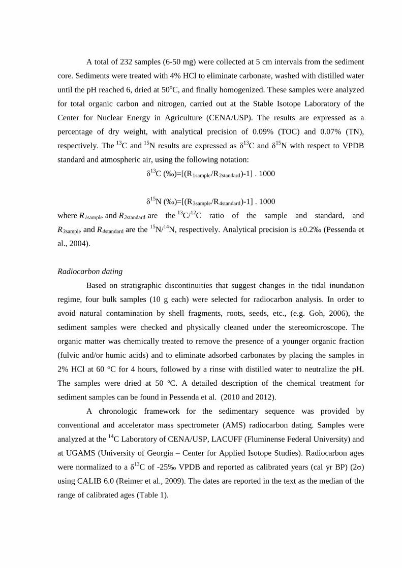
A total of 232 samples (6-50 mg) were collected at 5 cm intervals from the sediment
core. Sediments were treated with 4% HCl to eliminate carbonate, washed with distilled water
until the pH reached 6, dried at 50oC, and finally homogenized. These samples were analyzed
for total organic carbon and nitrogen, carried out at the Stable Isotope Laboratory of the
Center for Nuclear Energy in Agriculture (CENA/USP). The results are expressed as a
percentage of dry weight, with analytical precision of 0.09% (TOC) and 0.07% (TN),
respectively. The 13C and 15N results are expressed as δ13C and δ15N with respect to VPDB
standard and atmospheric air, using the following notation:
δ13C (‰)=[(R1sample/R2standard)-1] . 1000
δ15N (‰)=[(R3sample/R4standard)-1] . 1000
where R1sample and R2standard are the 13C/12C ratio of the sample and standard, and
R3sample and R4standard are the 15N/14N, respectively. Analytical precision is ±0.2‰ (Pessenda et
al., 2004).
Radiocarbon dating
Based on stratigraphic discontinuities that suggest changes in the tidal inundation
regime, four bulk samples (10 g each) were selected for radiocarbon analysis. In order to
avoid natural contamination by shell fragments, roots, seeds, etc., (e.g. Goh, 2006), the
sediment samples were checked and physically cleaned under the stereomicroscope. The
organic matter was chemically treated to remove the presence of a younger organic fraction
(fulvic and/or humic acids) and to eliminate adsorbed carbonates by placing the samples in
2% HCl at 60 °C for 4 hours, followed by a rinse with distilled water to neutralize the pH.
The samples were dried at 50 ºC. A detailed description of the chemical treatment for
sediment samples can be found in Pessenda et al. (2010 and 2012).
A chronologic framework for the sedimentary sequence was provided by
conventional and accelerator mass spectrometer (AMS) radiocarbon dating. Samples were
analyzed at the 14C Laboratory of CENA/USP, LACUFF (Fluminense Federal University) and
at UGAMS (University of Georgia – Center for Applied Isotope Studies). Radiocarbon ages
were normalized to a δ13C of -25‰ VPDB and reported as calibrated years (cal yr BP) (2σ)
using CALIB 6.0 (Reimer et al., 2009). The dates are reported in the text as the median of the
range of calibrated ages (Table 1).
Table 1 – Sediment samples selected for Radiocarbon dating and results from LI-32 core (coastal plain of the Doce River) with material, depth, δ13C, 14C conventional and calibrated ages (using Calib 6.0; Reimer et al., 2009).
Cody site and laboratory
number
Depth (m)
Material Ages (14C yr BP,
1σ)
Ages (cal yr BP, 2σ
deviation)
Median of age range (cal yr
BP)
Sedimentation rates
LACUFF13019 0.67-0.72
Bulk sed. 2877 ± 79 3246-2840 3043 0.2 mm/yr
LACUFF12039 1.40-1.45 Bulk sed. 6237 ± 66 7278-6955
7116 0.2 mm/yr
UGAMS11695 3.40-3.45 Bulk sed. 6330 ± 30 7318-7172
7245 15.0 mm/yr
UGAMS11694 4.30-4.35 Bulk sed. 6380 ± 30 7339-7259
7300 16.0 mm/yr
LACUFF12040 5.45-5.50 Bulk sed. 7186 ± 54 8161-7933 8047 1.50 mm/yr
Results
Radiocarbon date and sedimentation rates
The radiocarbon dates are shown in Table 1 (range since ~ 8050 cal yr BP) and no
age inversions were observed. The sedimentation rates were based on the ratio between the
depth intervals (mm) and the time range. The calculated sedimentation rates are 1.5 mm/yr
(5.50-4.35 m), 16 mm/yr (4.35-3.45 m), 15 mm/yr (3.45 - 1.45 m), 0.2 mm/yr (1.45- 0.72 m)
and 0.2 mm/yr (0.72-0 m). Although the rates are non linear between the dated points,
they are same magnitude order with the vertical accretion range of 0.1 to 10 mm yr-1 of
mangrove forests reported by other authors (e.g. Cahoon and Lynch, 1997; Bird, 1980;
Spenceley, 1982; Behling et al., 2004; Cohen et al., 2005a; 2008; 2009; Guimarães et al.,
2010; Vedel et al., 2006).
Facies, pollen description and isotopes values from sediment core
The sediment is composed mostly of greenish gray or dark brown sandy silt with
grain size fining upward. The sediment facies are characterized by massive mud, parallel
laminated mud, cross stratified sand, parallel-laminated sand, lenticular and heterolithic
mud/sand, with peat present near the surface (Figures 3 and 4). The texture, grain size,
sedimentary structures and pollen content, complemented with isotopic and geochemical data
(δ13C, δ15N, TOC, N and C/N), define four facies associations representative of foreshore,
lagoon, lake, and herbaceous plain environments (Table 2).
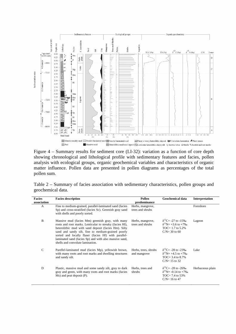
Figure 4 – Summary results for sediment core (LI-32): variation as a function of core depth showing chronological and lithological profile with sedimentary features and facies, pollen analysis with ecological groups, organic geochemical variables and characteristics of organic matter influence. Pollen data are presented in pollen diagrams as percentages of the total pollen sum. Table 2 – Summary of facies association with sedimentary characteristics, pollen groups and geochemical data.
Facies association
Facies description Pollen predominance
Geochemical data Interpretation
A Fine to medium-grained, parallel-laminated sand (facies Sp) and cross-stratified (facies Sc). Greenish gray sand with shells and poorly sorted.
Herbs, mangrove, trees and shrubs
Foreshore
B Massive mud (facies Mm) greenish gray, with many roots and root marks. Lenticular to streaky (facies Hl), heterolithic mud with sand deposit (facies Hm). Silty sand and sandy silt, fine to medium-grained poorly sorted and locally flaser (facies Hf) with parallel-laminated sand (facies Sp) and with also massive sand, shells and convolute lamination.
Herbs, mangrove, trees and shrubs
δ13C= -27 to -15‰ δ15N= +3.6 to +7‰ TOC= 1.7 to 5.2% C/N= 30 to 60
Lagoon
C Parellel-laminated mud (facies Mp), yellowish brown, with many roots and root marks and dwelling structures and sandy silt.
Herbs, trees, shrubs and mangrove
δ13C= -28 to -23‰ δ15N= +4.5 to +7‰ TOC= 3.4 to 8.7% C/N= 15 to 32
Lake
D Plastic, massive mud and some sandy silt, gray to dark gray and green, with many roots and root marks (facies Ms) and peat deposit (P).
Herbs, trees and shrubs
δ13C= -28 to -26‰ δ15N= -0.14 to +7‰ TOC= 7.4 to 53% C/N= 16 to 47
Herbaceous plain
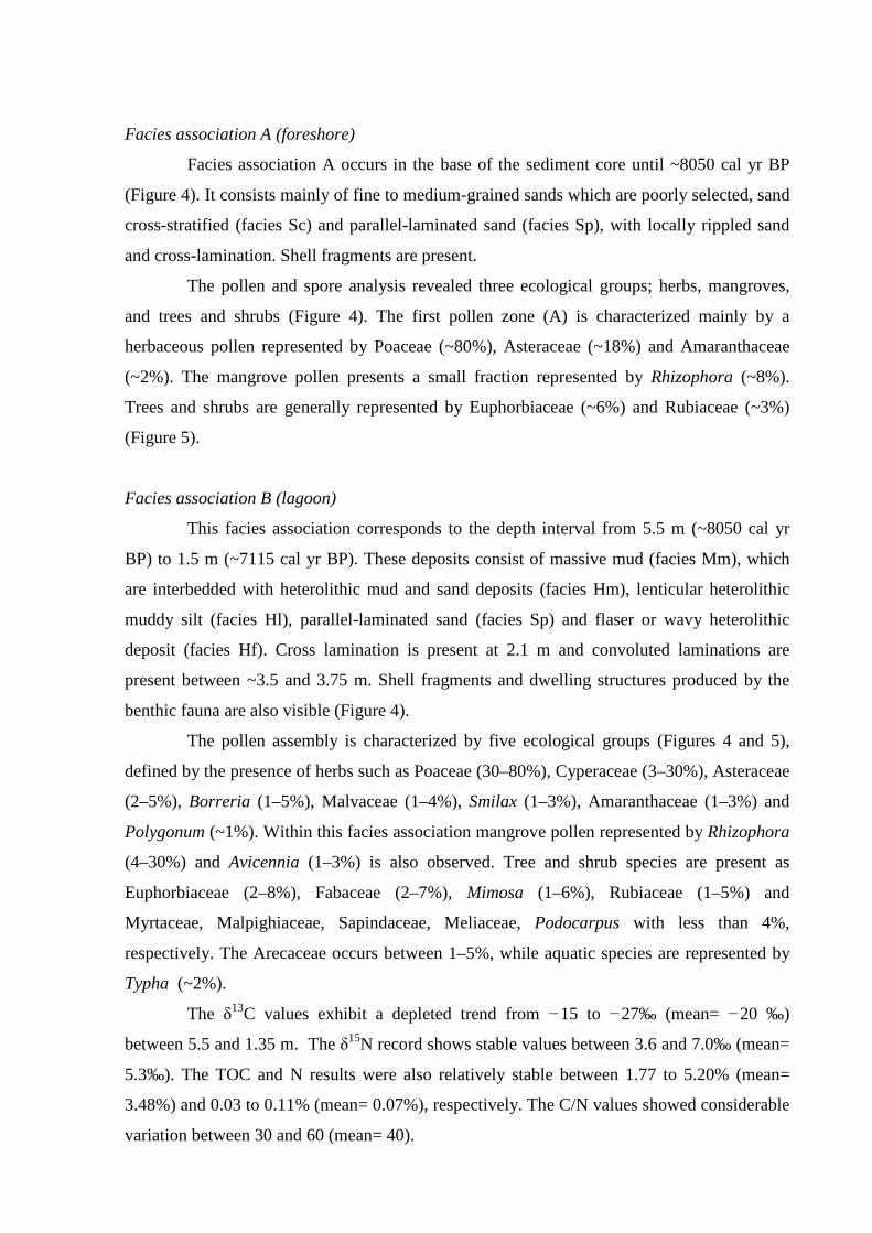
Facies association A (foreshore)
Facies association A occurs in the base of the sediment core until ~8050 cal yr BP
(Figure 4). It consists mainly of fine to medium-grained sands which are poorly selected, sand
cross-stratified (facies Sc) and parallel-laminated sand (facies Sp), with locally rippled sand
and cross-lamination. Shell fragments are present.
The pollen and spore analysis revealed three ecological groups; herbs, mangroves,
and trees and shrubs (Figure 4). The first pollen zone (A) is characterized mainly by a
herbaceous pollen represented by Poaceae (~80%), Asteraceae (~18%) and Amaranthaceae
(~2%). The mangrove pollen presents a small fraction represented by Rhizophora (~8%).
Trees and shrubs are generally represented by Euphorbiaceae (~6%) and Rubiaceae (~3%)
(Figure 5).
Facies association B (lagoon)
This facies association corresponds to the depth interval from 5.5 m (~8050 cal yr
BP) to 1.5 m (~7115 cal yr BP). These deposits consist of massive mud (facies Mm), which
are interbedded with heterolithic mud and sand deposits (facies Hm), lenticular heterolithic
muddy silt (facies Hl), parallel-laminated sand (facies Sp) and flaser or wavy heterolithic
deposit (facies Hf). Cross lamination is present at 2.1 m and convoluted laminations are
present between ~3.5 and 3.75 m. Shell fragments and dwelling structures produced by the
benthic fauna are also visible (Figure 4).
The pollen assembly is characterized by five ecological groups (Figures 4 and 5),
defined by the presence of herbs such as Poaceae (30–80%), Cyperaceae (3–30%), Asteraceae
(2–5%), Borreria (1–5%), Malvaceae (1–4%), Smilax (1–3%), Amaranthaceae (1–3%) and
Polygonum (~1%). Within this facies association mangrove pollen represented by Rhizophora
(4–30%) and Avicennia (1–3%) is also observed. Tree and shrub species are present as
Euphorbiaceae (2–8%), Fabaceae (2–7%), Mimosa (1–6%), Rubiaceae (1–5%) and
Myrtaceae, Malpighiaceae, Sapindaceae, Meliaceae, Podocarpus with less than 4%,
respectively. The Arecaceae occurs between 1–5%, while aquatic species are represented by
Typha (~2%).
The δ13C values exhibit a depleted trend from −15 to −27‰ (mean= −20 ‰)
between 5.5 and 1.35 m. The δ15N record shows stable values between 3.6 and 7.0‰ (mean=
5.3‰). The TOC and N results were also relatively stable between 1.77 to 5.20% (mean=
3.48%) and 0.03 to 0.11% (mean= 0.07%), respectively. The C/N values showed considerable
variation between 30 and 60 (mean= 40).
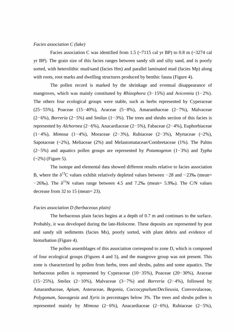
Facies association C (lake)
Facies association C was identified from 1.5 (~7115 cal yr BP) to 0.8 m (~3274 cal
yr BP). The grain size of this facies ranges between sandy silt and silty sand, and is poorly
sorted, with heterolithic mud/sand (facies Hm) and parallel laminated mud (facies Mp) along
with roots, root marks and dwelling structures produced by benthic fauna (Figure 4).
The pollen record is marked by the shrinkage and eventual disappearance of
mangroves, which was mainly constituted by Rhizophora (3−15%) and Avicennia (1−2%).
The others four ecological groups were stable, such as herbs represented by Cyperaceae
(25−55%), Poaceae (15−40%), Araceae (5−8%), Amaranthaceae (2−7%), Malvaceae
(2−6%), Borreria (2−5%) and Smilax (1−3%). The trees and shrubs section of this facies is
represented by Alchornea (2−6%), Anacardiaceae (2−5%), Fabaceae (2−4%), Euphorbiaceae
(1−4%), Mimosa (1−4%), Moraceae (2−3%), Rubiaceae (2−3%), Myrtaceae (~2%),
Sapotaceae (~2%), Meliaceae (2%) and Melastomataceae/Combretaceae (1%). The Palms
(2−5%) and aquatics pollen groups are represented by Potamogeton (1−3%) and Typha
(~2%) (Figure 5).
The isotope and elemental data showed different results relative to facies association
B, where the δ13C values exhibit relatively depleted values between −28 and −23‰ (mean=
−26‰). The δ15N values range between 4.5 and 7.2‰ (mean= 5.9‰). The C/N values
decrease from 32 to 15 (mean= 23).
Facies association D (herbaceous plain)
The herbaceous plain facies begins at a depth of 0.7 m and continues to the surface.
Probably, it was developed during the late-Holocene. These deposits are represented by peat
and sandy silt sediments (facies Ms), poorly sorted, with plant debris and evidence of
bioturbation (Figure 4).
The pollen assemblages of this association correspond to zone D, which is composed
of four ecological groups (Figures 4 and 5), and the mangrove group was not present. This
zone is characterized by pollen from herbs, trees and shrubs, palms and some aquatics. The
herbaceous pollen is represented by Cyperaceae (10−35%), Poaceae (20−30%), Araceae
(15−25%), Smilax (2−10%), Malvaceae (3−7%) and Borreria (2−4%), followed by
Amaranthaceae, Apium, Asteraceae, Begonia, Coccocypselum/Declieuxia, Convovulaceae,
Polygonum, Sauvagesia and Xyris in percentages below 3%. The trees and shrubs pollen is
represented mainly by Mimosa (2−6%), Anacardiaceae (2−6%), Rubiaceae (2−5%),
Malpighiaceae (2−4%), Alchornea (2−3%) and Fabaceae (1−2%), followed by
Anadenanthera, Melastomataceae/Combretaceae, Meliaceae and Mytaceae at around 1−2%,
respectively. The palm and aquatic pollen were below 2%, colonized by Arecaceae,
Hydrocleis, Typha and Utricularia.
The sediment δ13C values ranged between −28 and −26‰ (mean= −27‰). The
range for δ15N values was between −0.1 and 7‰. The C/N ratio varies between 47 and 16
(mean= 29).
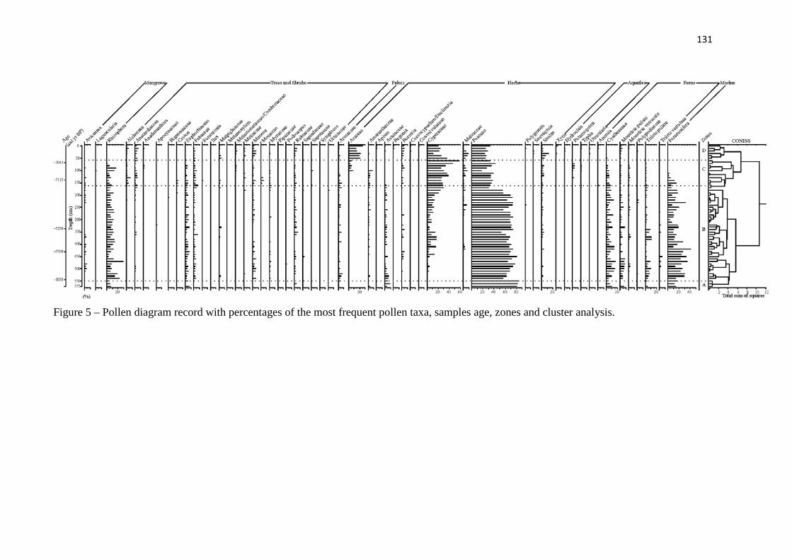
131
Figure 5 – Pollen diagram record with percentages of the most frequent pollen taxa, samples age, zones and cluster analysis.
132
Interpretation and discussion
The data suggest two phases of wetland development: (i) tidal flat colonized by
mangroves in the margin of the lagoon, where flow energy oscillated. In addition, the
geochemical data showed organic matter was influenced by C4 plants between ~8050 and
~7115 cal yr BP. The phase (ii) was characterized by mangrove extinctions, with an increased
influence of C3 plants and freshwater/estuarine dissolved organic matter, which occurred in
the lake and, then the development of a herbaceous plain, probably, during the late-Holocene
(Figure 7).
Early Holocene: foreshore to lagoon
The foreshore to lagoon phase was initially marked by a foreshore facies association
which exhibits shell fragments in cross-stratified sand and parallel-laminated sand (Figure 4),
which record the action of relatively weak currents shaping the bedform. These currents
induced the migration of small sand ripples (Reineck and Singh, 1980) between 6 and 5.60 m
depth. The ecological record for this region is characterized by mangrove development
associated with herbs, trees and shrubs (Figures 5 and 7). The lagoon facies is represented by
massive mud, heterolithic mud/sand, lenticular heterolithic muddy silt, parallel-laminated
sand, and flaser or wavy heterolithic deposits and cross-laminations. This assemblage of
structures may indicate tidal influence. During this period, the tidal flat in the margin of the
lagoon was occupied by mangroves, herbs, palms, trees and shrubs (Figure 7). Also during
this time, the development of the mangrove was largely represented by Rhizophora (4−30%),
which is associated with trees and shrubs (2−25%), and may have contributed to the upward
decrease of δ13C values from −15‰ to −23‰. It may represent a mixture of C3, C4 plants and
aquatic organic matter, as indicated by the binary diagram between the δ13C and C/N rate
(Figure 6). The C4 plants may be sourced from marine herbs, which have lower δ13C values
(between −17‰ and −9‰, Boutton, 1996). The δ15N values (mean= 5.2‰) suggest a mixture
of terrestrial plants and aquatic organic matter (~5.0‰, Sukigara and Saino, 2005).
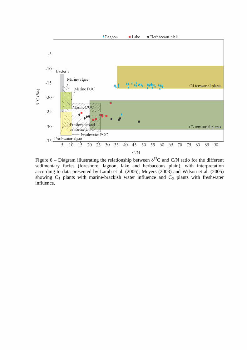
Figure 6 – Diagram illustrating the relationship between δ13C and C/N ratio for the different sedimentary facies (foreshore, lagoon, lake and herbaceous plain), with interpretation according to data presented by Lamb et al. (2006); Meyers (2003) and Wilson et al. (2005) showing C4 plants with marine/brackish water influence and C3 plants with freshwater influence.
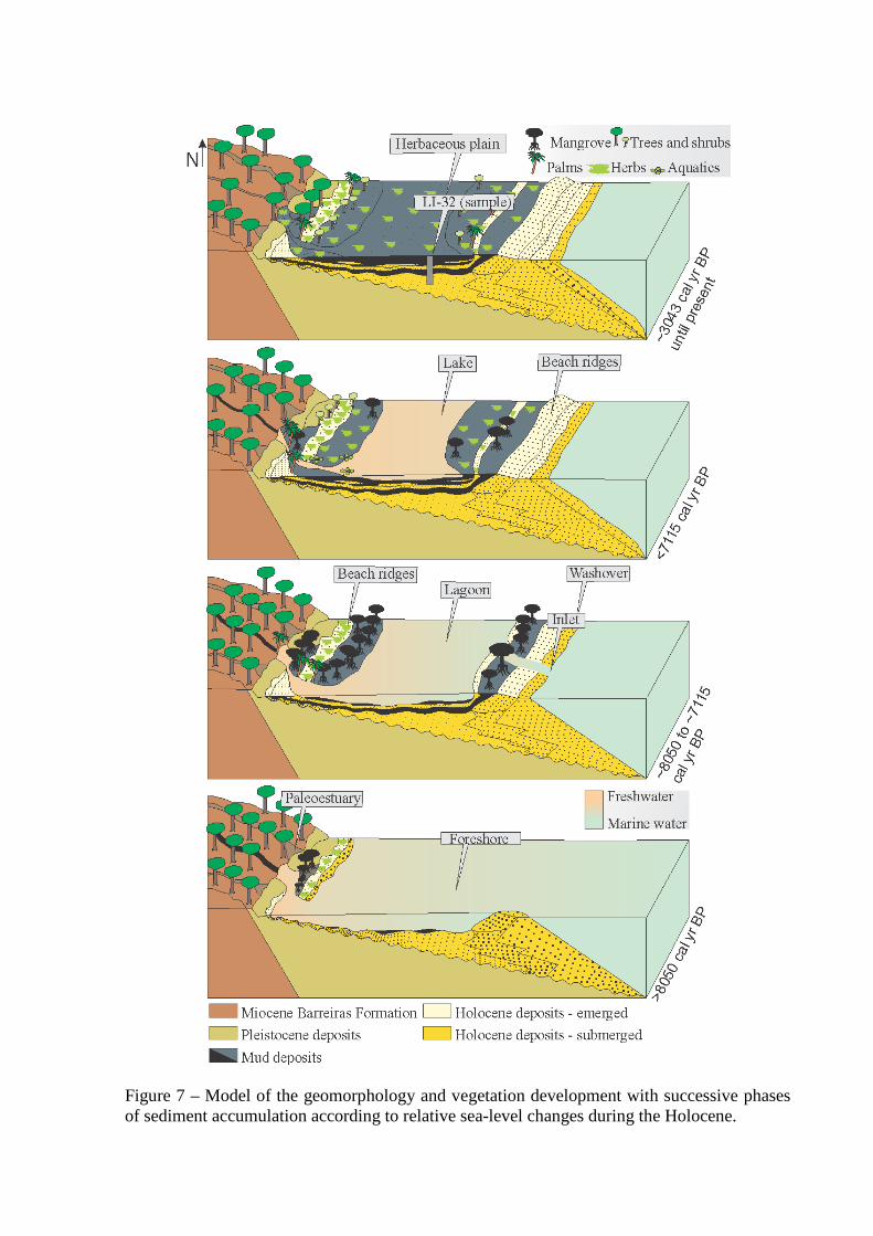
Figure 7 – Model of the geomorphology and vegetation development with successive phases of sediment accumulation according to relative sea-level changes during the Holocene.
Middle-Late Holocene: Lagoon/lake transition to herbaceous flat
The transition from a lagoon system to lake/herbaceous flat occurred after 7115 cal
yr BP. This environment is marked by increased influence of C3 plants. The sediment is
composed of sandy silt, parallel-laminated mud and some benthic tubes, roots, and root
marks, which indicate stagnant conditions. In this phase the mangrove ecosystem became
extinct at the study site. The disruption of the mangrove ecosystem during this period
indicates unfavorable conditions for mangrove development, which may have been due to
decreased pore water salinity. This salinity decrease would have allowed the colonization of
herbs, trees, shrubs, palms, and aquatic vegetation in the study site. The δ13C values from
−23‰ to −28‰, indicate an increased influence of C3 plants (−32‰ to −21‰; Deines,
1980). The relationship between δ13C and C/N values indicate a mixture of continental and
aquatic organic matter, which was dominantly composed of C3 plants. The presence of
aquatic material (Figure 5) indicates a lacustrine environment. The accumulation of mud and
organic matter into the lake led to the filling of lake depressions and expansion of a
herbaceous plain during the late-Holocene. During this time the vegetation was characterized
mainly by herbs, trees, and shrubs with distinctive isotopic signals and C/N values from C3
plants (Figure 6). The δ15N values exhibit a decreasing trend from 4.3‰ to −0.1‰ in
sediments close to the surface (0.7−0 m), suggesting a increased amount of terrestrial organic
matter (δ15N ~1‰, Peterson and Howarth, 1987; Fellerhoff et al., 2003). Normally aquatic
plants take up dissolved inorganic nitrogen, which is isotopically enriched in 15N by 7‰ to
10‰ relative to atmospheric N (0‰), and thus terrestrial plants that use N2 derived from the
atmosphere have δ15N values ranging from 0‰ to 2‰ (Meyers, 2003). The C/N ratio (mean=
29) also indicates organic matter from vascular plants (>12 vascular plants, Meyers, 1994;
Tyson, 1995). The binary diagram of δ13C vs. C/N ratio reveals the contribution of C3
terrestrial plants (Figure 6).
Holocene sea-level changes, climate and vegetation dynamics
The data suggest mangrove vegetation and C4 plants on a tidal flat surrounding a
lagoon between ~8050 and ~7115 cal yr BP. This phase was followed by a decrease in
mangrove habitat and an expansion of C3 terrestrial plants represented by herbs, trees and
shrubs. These results suggest a transition from marine to freshwater influence, likely due to
the combined action of RSL fall and sedimentary supply during the mid and late-Holocene.
During the lagoon phase (~8050 and ~7115 cal yr BP) the sedimentation rates (16.4 -
15.5 mm/yr) were higher than the lacustrine and herbaceous plain phase (0.2 mm/yr) over the

past ~7115 cal yr BP (Figure 4). It may be related to the post-glacial sea-level rise in the
early-Holocene, when more space was created to accommodate new sediments (Figure 8),
while during the mid and late-Holocene occurred RSL fall with the decrease in
accommodation space.
Changes in the RSL, sedimentary supply and river discharge during the Holocene are
important process that influenced not only the relative position of the shoreline, but also the
characteristics of coastal stratigraphic systems and vegetation dynamics (Scheel-Ybert, 2000;
Cohen et al., 2005a,b; Buso Jr., 2010; Guimarães et al., 2012; Smith et al., 2012; França et al.,
2012, Cohen et al., 2012) (Figure 8). Probably, the RSL changes along the Brazilian littoral
must be the main driving force controlling the mangrove dynamics, while the sedimentary
supply, mainly in the southern Brazil, and tidal water salinity, mainly in the northern Brazil,
may be considered as secondary causes (Cohen et al., 2012).
Figure 8 – RSL curves of the eastern Brazilian coast during the Holocene with comparative pollen diagrams from northern and southeast Brazil coastline.
Considering the RSL changes, references to the highstand along eastern coast of
Brazil can be found in several publications, including Suguio et al. (1985), Dominguez et al.
(1990), Angulo and Suguio (1995), Angulo and Lessa (1997), Angulo et al. (1999), Souza et
al. (2001), Bezerra et al. (2003), Martin et al. (2003) and Angulo et al. (2006).
The RSL curve during the mid- to late-Holocene, along northeastern Brazil, was
reconstructed by Martin et al. (2003), who showed that RSL exceeded the present level
around 7700 cal yr BP and 5600 cal yr BP, followed by fast regression between 5300 and
4200 cal yr BP when the RSL may have been below the current level. (Figure 8). A fast rise
occurred again approximately 3700 cal yr BP with a maximum of 3.5 ± 0.5 m above the

present RSL, followed by a steady and slow decrease between 3500 and 2800 cal yr BP. At
2800 cal yr BP, sea level fell quickly, falling below the current level by 2600 cal yr BP. About
2300 cal yr BP, RSL began to rise, reaching 2.3 ± 0.5 m above the present level by 2100 cal
yr BP. After 2100 cal yr BP RSL fell steadily to its current position (Figure 8). Others studies
performed along the eastern and southeastern Brazilian coast also showed the existence of
three paleo-sea-levels higher than the present (Suguio et al., 1982, 1985; Martin et al., 1987,
1996). However, Angulo et al. (2006) proposed a mid-Holocene RSL maximum above
present RSL and subsequent fall to the present time, without subsequent oscillation (Figure 8).
Along the coast of southeastern Brazil, higher RSL led to the formation of numerous
lagoons (Sallun et al., 2012), and estuaries as observed in a recent study developed in the
region (Buso Jr., 2010). This information is relevant to our study because between >8050 and
~7115 cal yr BP the sedimentary features reveal a facies association typically of foreshore and
lagoon systems with mangrove, likely a consequence of high RSL during this time (Figure 8).
During the mid and late-Holocene there was a retraction of mangrove and expansion of
herbaceous vegetation, trees and shrubs followed by an increase in the contribution of
freshwater organic matter. During this phase, a lake was developed following a regressive
phase. During this period C3 plants became the dominant vegetation in the study region. The
flow of sediments led to siltation and infilling of the lacustrine setting, causing the expansion
of the herbaceous plain ecosystem seen today (Figure 7).
Conclusion
This study indicates the presence of a lagoon system surrounded by a tidal plain
colonized by mangroves, and its sedimentary organic matter sourced from C4 plants, between
~8050 and ~7115 cal yr BP. However, during the mid and late-Holocene the mangroves
shrank and freshwater vegetation expanded (C3 plants), probably, due to the combined action
of RSL fall and sedimentary supply. During this time, the development of a lacustrine
environment was followed by the colonization of herbs, trees and shrubs. The continuous
infilling of sediment into the lake allowed the expansion of a herbaceous plain, as seen today.
The geomorphologic and vegetation evolution is in agreement with the mid-Holocene RSL
maximum above present RSL and subsequent fall to the present time, as proposed by Angulo
et al. (2006).
REFERENCES
Absy, M.L., 1975. Polen e esporos do Quaternário de Santos (Brasil). Hoehnea 5, 1-26.
Absy, M.L., Cleef, A., Fournier, M., Martin, L., Servant, M., Sifeddine, A., Ferreira da Silva,
M., Soubies, F., Suguio, K., Turcq, B., Van Der Hammen, T.H., 1991. Mise en evidence
de quatre phases d'overture de la forêt dense dans le sud-est de l'Amazonie au cours des
60,000 dernieres annees. Premiere comparision avec d'autres regions tropicales. Comptes
Rendus de l'Académie des Sciences. Paris t.312, 673–678 (Serie II).
Alongi, D.M., Sasekumar, A., Tirendi, F., Dixon, P., 1998. The influence of stand age on
benthic decomposition and recycling of organic matter in managed mangrove forests of
Malaysia. Journal of Experimental Marine Biology and Ecology 225. 197–218.
Alongi, D.M., Tirendi, F., Dixon, P., Trott, L.A., Brunskill, G.J., 1999. Mineralization of
Organic Matter in Intertidal Sediments of a Tropical Semi-enclosed Delta. Estuarine,
Coastal and Shelf Science 48, 451–467.
Alongi, D.M., Tirendi, F., Clough, B.F., 2000. Below-ground decomposition of organic
matter in forests of the mangrove Rhizophora stylosa and Avicennia marina along the
arid coast of Western Australia. Aquatic Botany 68, 97–122.
Alongi, D.M., 2002. Present state and future of the world’s mangrove forests. Environmental
Conservation 29, 331-349.
Alongi, D.M., 2008. Mangrove forests: Resilience, protection from tsunamis, and responses to
global climate change. Estuarine, Coastal and Shelf Science 76, 1–13.
Altabet, M.A., McCarthy, J.J., 1985. Temporal and spatial variations in the natural abundance
of 15N in PON from a warm-core ring. Deep-Sea Res. 32, 755–772.
Amaral, P.G.C., Ledru, M.P., Branco, F.R., Giannini, P.C.F., 2006. Late Holocene
development of a mangrove ecosystem in southeastern Brazil (Itanhaém, state of São
Paulo). Palaeogeography, Palaeoclimatology, Palaeoecology 241, 608–620.
Amaral, P.G.C., Giannini, P.C.F., Sylvestre, F., Pessenda, L.C.R., 2012. Paleoenviromental
reconstruction of a Late Quaternary lagoon system in southern Brazil (Jaguaruna region,
Santa Catarina state) based on multi-proxy analysis. Journal of Quaternary Science 27,
181–191.
Amarasekera, K. N., Lee, R.F., Williams, E.R., Eltahir, E.A.B., 1997. ENSO and the natural
variability in the flow of tropical rivers. Journal of Hydrology 200, 24–39.
ANA, 2003. Hydrological information system. Brazilian National Water Agency. On line
dataset, 14.3 MB, http://hidroweb.ana.gov.br/baixar/mapa/Bacia1.zip.
Andersen, S.T., 1967. Tree-pollen rain in a mixed deciduous forest in south Jutland
(Denmark). Review Palaeobotany Palynology 3, 267–275.
Andersen, S.T., 1970. The relative pollen productivity and pollen representation of north
European trees, and correction factors for tree pollen spectra. Dan. Geol. Surv. Trans.
Ser. 2 (96), 1–99.
Angulo, R.J., Suguio, K., 1995. Re-evaluation of the Holocene sea-level maxima for the State
of Paraná, Brazil. Palaeogeography, Palaeoclimatology, Palaeoecology 113, 385–393.
Angulo, R.J., Lessa, G.C., 1997. The Brazilian sea-level curves: a critical review with
emphasis on the curves from Paranaguá and Cananéia regions. Marine Geology 140,
141–166.
Angulo, R.J., Giannini, P.C.F., Suguio, K., Pessenda, L.C.R., 1999. Relative sea-level
changes in the last 5500 years in southern Brazil (Laguna – Imbituba region, Santa
Catarina State) based on vermitid 14C ages. Marine Geology 159, 323–339.
Angulo, R.J., Lessa, G.C., Souza, M.C., 2006. A critical review of the mid- to late Holocene
sea-level fluctuations on the eastern brazilian coastline. Quaternary Science Reviews 25,
486–506.
Angulo, R.J., de Souza, M.C., Assine, M.L., Pessenda, L.C.R., Disaró, S.T., 2008.
Chronostratigraphy and radiocarbon age inversion in the Holocene regressive barrier of
Paraná, southern Brazil. Marine Geology 252, 111–119.
Arai, M., 1997. Dinoflagelados (Dinophyceae) miocênicos do Grupo Barreiras no nordeste de
Estado do Pará (Brasil). Guarulhos: Revista Universidade Guarulhos, Geociências II (n°
especial): 98-106.
Arai, M., 2006. A grande elevação eustática do Mioceno e sua influência na origem do Grupo
Barreiras. Geologia USP Série Científica 6, 1–6.

Asmus, H.E., Gomes, J.B., Pereira, A.C.B., 1971. Integração geológica regional da bacia do
Espírito Santo – Anais do XXV Congresso Brasileiro de Geologia, v.3: 235–254, São
Paulo.
Baltzer, F., 1970. Etude sédimentologique du marais de Mara (Côte ouest de la Nouvelle
Calédonie) et de formations quaternaires voisines. Mémoires expédition française sur lês
récifs coralliens de la Nouvelle Calédonie. Foundation Singer-Polignac 4, 146–169.
Baltzer, F., 1975. Solution of silica and formation of quartz and smectite in mangrove swamps
and adjacent hypersaline marsh environments. Proceedings of the International
Symposium on Biology and Management of Mangroves, University of Florida, Orlando,
Florida, pp. 482–498.
Bard, E., Hamelin, B., Fairbanks, R.G., 1990. U–Th ages obtained by mass spectrometry in corals
from Barbados: sea level during the past 130,000 years. Nature 346, 456–458.
Bard, E., 2012. A review on sea-level changes during deglaciations. Quaternary International 279–
280, 9–120.
Barreto, A. M. F., Bezerra, F. H. R., Suguio, K., Tatumi, S. H., Yee, M., R.P. Paiva., C.S.
Munita. 2002. Late Pleistocene marine terrace deposits in northeastern Brazil: sea level change
and tectonic implications. Palaeogeography, Palaeoclimatology, Palaeoecology 179, 57-69.
Barth, J.A.C., Veizer, J., Mayer, B., 1998. Origin of particulate organic carbon in the upper
St. Lawrence: Isotopic constraints. Earth and Planetary Science Letters 162, 111–121.
Bassinot, F., Labeyrie, L., Vincent, E., Quidelleur, X., Lancelot, N.J., Lancelot, Y., 1994. The
astronomical theory of climate and the age of the Brunhes–Matuyama magnetic reversal. Earth
and Planetary Sciences Letters 126, 91–108.
Behling, H., 1993. Untersuchungen zur Spätpleistozänen und Holozänen Vegetations und
Klimageschichte der Tropischen Küstenwälder und der Araukarienwälder in Santa
Catarina (Südbrasilien). Dissertationes Botanicae, Berlin, Deutschland.
Behling, H., Hooghiemstra, H., Negret, A.J., 1998. Holocene history of the Choco rain forest
from Laguna Piusbi, southern Pacific lowlands of Colombia. Quaternary Research 50 (3),
300–308.
Behling, H., Costa, M.L., 2000. Holocene environmental changes from the Rio Curuá record
in the Caxiuanã region, eastern Amazon Basin. Quaternary Research 53, 369–377.

Behling, H., Costa, M.L., 2001. Holocene vegetational and coastal environmental changes
from the Lago Crispim record in northeastern Pará State, eastern Amazonia. Review of
Paleobotany and Palynology 114, 145–155.
Behling, H., Hooghiemstra, H., 2000. Holocene Amazon rainforest–savanna dynamics and
climatic implications: high-resolution pollen record from Laguna Loma Linda in eastern
Colombia. Journal of Quaternary Science 15, 687–695.
Behling, H., 2001. Late Quaternary environmental changes in the Lagoa da Curuca region
(eastern Amazonia) and evidence of Podocarpus in the Amazon lowland. Vegetation
History and Archaeobotany, 10, 175–183.
Behling, H., Cohen, M.C.L., Lara, R.J., 2001. Studies on Holocene mangrove ecosystem
dynamics of the Bragança Peninsula in north-eastern Pará, Brazil. Palaeogeography,
Palaeoclimatology, Palaeoecology 167, 225–242.
Behling, H., Cohen, M.C.L., Lara, R.J., 2004. Late Holocene mangrove dynamics of the
Marajó Island in northern Brazil. Vegetation History and Archaeobotany 13, 73–80.
Behling, H., Pillar, V.D., Müller, S.C., Overbeck, G.E., 2007. Late-Holocene fire history in a
forest-grassland mosaic in southern Brasil: implications for conservation. Applied
Vegetation Science 10, 81–90.
Bemerguy, R.L., 1981. Estudo sedimentológico dos paleocanais da região do Rio Paracauari,
Ilha do Marajó – Estado do Pará. 1981. 95p. Dissertação de Mestrado – NCGG-UFPA.
Belém (PA).
Berger, U., Rivera-Monroy, V.H., Doyle, T.W., Dahdouh-Guebas, F., Duke, N.C., Fontalvo-
Herazo, M.L., Hildenbrandt, H., Koedam, N., Mehlig, U., Piou, C., Twilley, R., 2008.
Advances and limitations of individual-based models to analyze and predict dynamics of
mangrove forests: A review. Aquatic Botany 89, 260–274.
Bernini, E., Silva, M.A.B., Carmo, T.M.S., Cuzzuol, G.R.F., 2006. Composição química do
sedimento e de folhas das espécies do manguezal do estuário do Rio São Mateus, Espírito
Santo, Brasil. Revista Brasileira de Botânica 29, 689–699.
Bezerra, F.H.R., Barreto, A.M.F., Suguio, K., 2003. Holocene sea-level history on the Rio
Grande do Norte State coast, Brazil. Marine Geology 196, 73–89.
Bird, E.C.F., 1980. Mangroves and coastal morphology. The Victorian Nauralist 97, 48–58.
Bittencourt, A.C.S.P., Martin, L., Vilas-Boas, G.S., Flexor, J.M., 1979. Quaternary marine
formations of the coast of the State of Bahia, Brazil. Coastal Evolution in the Quaternary,
232–253.
Bittencourt, A.C.S.P., Dominguez, J.M.L., Martin, L., Silva, I.R., De-Medeiros, K.O.P., 2007.
Past and current sediment dispersion pattern estimates through numerical modeling of
wave climate: an example of the Holocene delta of the Doce River, Espírito Santo, Brazil.
Anais da Academia Brasileira de Ciências 79, 333–341.
Blasco, F., Saenger, P., Janodet, E., 1996. Mangrove as indicators of coastal change. Catena
27, 167–178.
Boutton, T.W., 1996. Stable carbon isotope ratios of soil organic matter and their use as
indicators of vegetation and climate change. In: Boutton, T.W., Yamasaki, S.I. (Eds.).
Mass spectrometry of soils. Marcel Dekker, New York, NY.
Bruguière, L.G., 1789. Encyclopedie methodique. Histoire naturelle des Vers: Paris and
Liege, Panckouche & Plomteux. A. Bul.
Bruun, P., 1962. Sea level rise as a cause of shore erosion. Am. Soc. Civ. Eng. Proc., J.
Waterw. Harb. Div. 88, 117–130.
Brush, G.S., Brush, L.M.J., 1972. Transport of pollen in a sediment laden channel: a
laboratory study American Journal of Science 272, 359–381.
Bush M.B., Colinvaux P.A., 1988. A 7000-year pollen record from the Amazon lowlands,
Ecuador. Vegetatio 76, 141–154.
Bush, M.B., 1994. Amazonian speciation: a necessarily complex model. Journal
Biogeography 21, 5–18.
Bush, M.B., Silman, M.R., Urrego, D.H., 2004. 48.000 years of climate and forest change
from biodiversity hotspot. Science 303, 827–829.
Bush, M.B., Silman, M.R., Listopad, C.M.C.S., 2007. A regional study of Holocene climate
change and human occupation in Peruvian Amazonia. Journal of Biogeography 34, 1342–
1356.
Buso Junior, A.A., 2010. Dinâmica ambiental holocênica (vegetação, clima e nível relativo
marinho) baseada em estudos interdisciplinares de alta resolução, no litoral norte do
estado do Espírito Santo. Piracicaba – SP: Universidade de São Paulo, Programa de Pós-
Graduação em Ciências, Dissertação de Mestrado, p.190.
Buso Junior, A.A., Pessenda, L.C.R., de Oliveira, P.E., Giannini, P.C.F., Cohen, M.C.L.,
Volkmer-Ribeiro, C., Oliveira, S.M.B., Favaro, D.I.T., Rossetti, D.F., Lorente, F.L.,
Borotti Filho, M.A., Schiavo, J.A., Bendassolli,J.A., Franca, M.C., Guimaraes, J.T.F.,
Siqueira, G.S., 2013 – in press. From an estuary to a freshwater lake: a paleo-estuary
evolution in the context of Holocene sea-level fluctuations, southeastern Brazil.
Radiocarbon.
Cahoon, D.R., Lynch, J.C., 1997. Vertical accretion and shallow subsidence in a mangrove
forest of southwestern Florida, U.S.A. Mang. Salt Marsh. 3, 173–186.
Cahoon, D.R., Hensel, P.F., Spencer, T., Reed, D.J., McKee, K.L., Saintilan, N., 2006.
Coastal wetland vulnerability to relative sea-level rise: wetland elevation trends and
process controls, in: J.T.A Verhoeven, B. Beltman, R. Bobbing, D.F. Whigham (Eds.),
Wetlands and Natural Resource Management, Springer-Verlag, Berlin, pp. 271–292.
Camargo, M.G., 1999. SYSGRAN for Windows: Granulometric Analysis System. Pontal do
Sul, Paraná, Brazil.
Carvalho, L.M.V., Jones, C., Liebmann, B., 2004. The South Atlantic Convergence Zone:
intensity, form, persistence, and relationships with intraseasonal to interanual activity and
extreme rainfall. Journal of Climate 17, 88–108.
Castro, D.F., Rossetti, D.F., Pessenda, L.C.R., 2010. Facies, δ13C, δ15N and C/N analyses in a
late Quaternary compound estuarine fill, northern Brazil and relation to sea level. Marine
Geology 274, 135–150.
Chapman, V.J., 1976. Mangrove vegetation. Velag Von J. Cramer, Leutershausen, Germany,
p. 447.
Chappell, J., Shackleton, N.J., 1986. Oxygen isotopes and sea level. Nature 324, 137–140.
Chappell, J., Woodroffe, C.D., 1994. Macrotidal estuaries, in: Carter, R.W.G., Woodroffe,
C.D. (Eds.), Coastal Evolution: Late Quaternary Shoreline Morphodynamics. Cambridge
Univ. Press, Cambridge, pp. 187–218.
Chivas, A.R., Garcia, A., Van der Kaars, S., Couapel, M.J.J., Holt, S., Reeves, J.M., 2001.
Sea-level and environmental changes since the last interglacial in the Gulf of Carpentaria,
Australia: An overview. Quaternary International 85, 19–46.
Clark, M.W., McConchie, D.M., Lewis, D.W., Saenger, P., 1998. Redox stratification and
heavy metal partitioning in Avicennia-dominated mangrove sediments: a geochemical
model. Chemical Geology 149, 147–171.
Cohen, M.C.L., 2003. Past and current mangrove dynamics on the Bragança Península,
northern Brazil. Ph.D. Thesis, University of Bremen, Center for Tropical Marine
Ecology, Bremen, Germany.
Cohen, M.C.L., Lara, R.J., 2003. Temporal changes of mangrove vegetation boundaries in
Amazonia: Application of GIS and remote sensing techniques. Wetlands Ecology and
Management 11, 223–231.
Cohen, M.C.L., Behling, H., Lara, R.J., 2005a. Amazonian mangrove dynamics during the
last millennium: the relative sea-level and the little Ice Age. Review of Palaeobotany and
Palynology 136, 93–108.
Cohen, M.C.L., Souza Filho, P.W., Lara, R.L., Behling, H. Angulo, R., 2005b. A model of
Holocene mangrove development and relative sea-level changes on the Bragança
Peninsula (northern Brazil). Wetlands Ecology and management 13, 433–443.
Cohen, M.C.L., Lara, R.J., Smith, C.B., Angélica, R.S., Dias, B.S., Pequeno, T., 2008.
Wetland dynamics of Marajó Island, northern Brazil, during the last 1000 years. Catena
76, 70–77.
Cohen, M.C.L., Lara, R.J., Smith, C.B., Matos, H.R.S., Vedel, V., 2009. Impact of sea-level
and climatic changes on the Amazon coastal wetlands during the late Holocene.
Vegetation History and Archaeobotany 18, 425–439.
Cohen, M.C.L., Pessenda, L.C.R., Behling, H., Rossetti, D.F., França, M.C., Guimarães,
J.T.F., Friaes, Y., Smith, C.B., 2012. Holocene palaeovironmental history of the
Amazonian mangrove belt. Quaternary Science Reviews 55, 50–58.
Colinvaux, P.A., De Oliveira, P.E., Moreno, J.E., Miller, M.C., Bush, M.B., 1996. A long
pollen record from lowland Amazonia: forest and cooling in glacial times. Science 247,
85-88.
Colinvaux, P.A.,1998. A new vicariance model for Amazonian endemics. Glob. Ecol.
Biogeogr. Lett. 7, 95–96.
Colinvaux, P., De Oliveira, P.E., Patiño, J.E.M., 1999. Amazon Pollen Manual and Atlas.
Harwood Academic Publishers, Dordrecht. 332 p.
Colinvaux, P.A., De Oliveira, P.E., Bush, M.B., 2000. Amazonian and neotropical plant
communities on glacial time-scales: the failure of the aridity and refuge hypothesis.
Quaternary Science Reviews 19, 141–169.
Collinson, J., Mountney, N., Thompson, D., 2006. Sedimentary Structures (Third edition),
Terra Publishing, 292 pp.
Cutler, K.B., Edwards, R.L., Taylor, F.W., Cheng, H., Adkins, J., Gallup, C.D., Cutler, P.M., Burr,
G.S., Bloom, A.L., 2003. Rapid sea-level fall and deep ocean temperature change since the last
interglacial period. Earth and Planetary Science Letters 206, 253–271.
Da Costa E.M., 1778. Historia Naturalis Testaceorum Britanniae. London: Millan, White,
Elmsley and Robson XII 254 VIII p., 17 pl.
D’Alpaos, A., Lanzoni, S., Marani, M., Rinaldo, A., 2007. Landscape evolution in tidal
embayments: Modeling the interplay of erosion, sedimentation, and vegetation dynamics.
Journal of Geophysical Research Earth Surface 112, 1–17.
Dall, W.H., 1881. Reports on the results of dredging, under the supervision of Alexander
Agassiz, in the Gulf of Mexico and in the Caribbean Sea (1877-78), by the United States
Coast Survey Steamer "Blake", Lieutenant-Commander C.D. Sigsbee, U.S.N., and
Commander J.R. Bartlett, U.S.N., commanding. XV. Preliminary report on the Mollusca.
Bulletin of the Museum of Comparative Zoölogy at Harvard College 9 (2), 33–144.
Dall, W. H., 1890. Scientific results of explorations by the U. S. Fish Commission Steamer
Albatross. No. VII.--Preliminary report on the collection of Mollusca and Brachiopoda
obtained in 1887-'88. Proceedings of the United States National Museum 12 (773), 219–
362, pls. 5-14.
Dalrymple, R.W., Knight, R.J., Zaitlin, B.A., Middleton, G.V., 1990. Dynamics and facies
model ofa macrotidal sand-bar complex, Cobequid Bay-Salmon River estuary (Bay of
Fundy). Sedimentology 37, 577–612.
Dalrymple, W. R., Zaitlin, B. A., Boyd, R., 1992. Estuarine facies models: conceptual basis
and stratigraphic implications. Journal of Sedimentary Petrology 62 (6), 1130–1146.
Davis, M.B., 2000. Palynology after Y2K—understanding the source area of pollen in
sediments. Annual Review Earth Planetary Science 28, 1–18.
Departamento de Hidrografia e Navegação (DHN), Marinha do Brasil, 2003. Rio de Janeiro,
Brasil.
Desjardins T., Filho A.C., Mariotti A., Chauvel A., Girardin C., 1996. Changes of the forest
savanna boundary in Brazilian Amazonia during the Holocene as revealed by soil organic
carbon isotope ratios. Oecologia 108, 749–756.
Deines, P., 1980. The isotopic composition of reduced organic carbon. In: Fritz, P., Fontes,
J.C. (Eds.), Handbook of Environmental Isotope Geochemistry. The Terrestrial
Environments, Vol. 1, Amsterdam: Elsevier, 329–406.
Dillenburg, S. R., Barboza, E. G., Tomazelli, L.J., Hesp, P. A.; Clerot, L. C. P., Zouain, R. N.
A., 2009. The Holocene Coastal Barriers of Rio Grande do Sul. In: Sergio Rebello
Dillenburg; Patrick Alan Hesp. (Org.). Geology and Geomorphology of Holocene Coastal
Barriers of Brazil. Berlin/Heidelberg: Springer vol. 107, pp. 53–91.
Dominguez, J.M.L., Bittencourt, A.C.S.P., Leão, Z.M.A.N., Azevedo, A.E.G., 1990. Geologia
do Quaternário costeiro do estado de Pernambuco. Revista Brasileira de Geociências 20,
208–215.
Dominguez, J.M.L., Bittencourt, A.C.S.P., Martin, L., 1992. Controls on Quarternary coastal
evolution of the east-northeastern coast of Brazil: roles of sea-level history, trade winds
and climate. Sedimentary Geology 80, 213–232.
Dominguez, J.M.L., 2006. The coastal zone of Brazil – an overview. Journal of Coastal
Research 39, 16–20.
Dominguez, J.M.L., 2009. The Coastal Zone of Brazil, in: Dillenburg, S. R., Hesp, P. A.
(Eds.), Geology and geomorphology of Holocene Coastal Barriers of Brazil. Springer-
Verlag, Berlin, pp. 17–51.
Dominguez, J.M.L., Andrade, A.C.S., Almeida, A.B., Bittencourt, A.C.S.P., 2009. The
Holocene Barrier Strandplains of the State of Bahia. In: Dillenburg S., and Hesp, P. (Ed.),
Geology and Geomorphology of Holocene Coastal Barriers of Brazil. Springer, Berlin,
Germany, pp. 253–288.
Duclos, P.L., 1840. Histoire Naturelle Générale et de Tous les Particulière Genres de
Coquilles Marines univalves vivant l'etat et um Fossile, Monografias par Publiee,
Columbella Gênero. Didot, Paris, p. 1, 13 pls.
Duke, N.C., Pinzón, Z.S.M., Prada, M.C., 1997. Large-Scale Damage to Mangrove Forests
Following Two Large Oil Spills in Panama. Biotropica 29, 2–14.
Eisma D., Augustinus P.G.E.F., Alexander C., 1991. Recent and subrecent changes in the
dispersal of Amazon mud. Netherlands Journal of Sea Research 28, 181–192.
Ellison, J.C., 2005. Holocene palynology and sea-level change in two estuaries in Southern
Irian Jaya. Palaeogeography, Palaeoclimatology, Palaeoecology 220, 291–309.
Engelhart, S.E., Horton, B.P., Roberts, D.H., Bryant, C.L., Corbett, D.R., 2007. Mangrove
pollen of Indonesia and its suitability as a sea-level indicator. Marine Geology 242, 65–
81.
Evin, J., Marechal, J., Pachiaudi, C., 1980. Conditions involved in dating terrestrial shells.
Radiocarbon 22, 545-555.
Faegri, K., Iversen, J., 1989. Textbook of Pollen Analysis. . 4th ed.Wiley, Chichester, 328 pp.
Fairbanks, R.G., 1989. A 17,000-year glacio-eustatic sea level record: influence of glacial melting
dates on the Younger Dryas event and deep-ocean circulation. Nature 342, 637–642.
Fellerhoff, C., Voss, M., Wantzen, K.M., 2003. Stable carbon and nitrogen isotope signatures
of decomposing tropical macrophytes. Aquatic Ecology 37, 361–375.
França, M.C. 2010. Mudanças na vegetação do litoral leste da Ilha de Marajó durante o
Holoceno superior. Belém: Universidade Federal do Pará, Programa de Pós-Graduação
em Geologia e Geoquímica, Dissertação de Mestrado, p.111.
França, M., Francisquini, M.I. ,Cohen, M.C.L. ,Pessenda, L.C.R., Rosseti, D.F., Guimarães,
J., Smith, C. B., 2012. The last mangroves of Marajó Island - Eastern Amazon: impact of
climate and/or relative sea-level changes. Review of Palaeobotany and Palynology 187,
50–65.
França, M.C., Cohen, M.C.L., Pessenda, L.C.R., Rossetti, D.F., Lorente, F.L., Buso-Junior,
A.A., Guimarães, J.T.F., Friaes, Y., 2013a. Mangrove dynamics in response to sea-level
changes on Holocene terraces of the Doce River, southeastern Brazil. Catena.
França, M.C., Francisquini, M.I., Cohen, M.C.L., Pessenda, L.C.R., 2013b – in press. An
inter-proxy approach to assessing the development of the Amazonian mangrove, northern
Brazil. Vegetation History and Archaeobotany.
França, C.F., Sousa Filho, P.W.M., 2006. Compartimentação morfológica da margem leste da
ilha de Marajó: zona costeira dos municípios de Soure e Salvaterra – Estado do Pará.
Revista Brasileira de Geomorfologia 1, 33–42.
French, J.R., Stoddart, D.R., 1992. Hydrodynamics of saltmarsh creek systems: Implications
for marsh morphological development and material exchange. Earth Surface Process and
Landforms 17, 235–252.
Freitas, H.A., Pessenda, L.C.R., Aravena, R., Gouveia, S.E.M., Ribeiro, A.S., Boulet, R.,
2001. Late Quaternary vegetation dynamics in the southern Amazon sasin inferred from
carbon isotopes in soil organic matter. Quaternary Research 55, 39–46.
Freitas, R.A.P., Douglas Lindemann, D., Souza, L.S., Faria, H., Santos, M., Elesbon, A.,
Casagrande, F., 2010. Análise de Séries Temporais de Vazão e Precipitação na Bacia
Hidrográfica do Rio São Mateus. In: Anais do XVI Congresso Brasileiro de
Meteorologia, Belém, PA.
Fromard, F., Vega, C., Proisy, C., 2004. Half a century of dynamic coastal change affecting
mangrove shorelines of French Guiana. A case study based on remote sensing data
analyses and field surveys. Marine Geology 208, 265–280.
Fry, B., Scalan, R.S., Parker, P.L., 1977. Stable carbon isotope evidence for two sources of
organic matter in coastal sediments: seagrass and plankton. Geochimica et Cosmochimica
Acta 41, 1875–1877.
Fu, R., Dickinson, R.E., Chen, M., Wang, H., 2001. How do tropical sea surface temperatures
influence the seasonal distribution of precipitation in the equatorial Amazon? Journal of
Climate 14, 4003–4026.
Fujimoto, K., Miyagi, T., Kikuchi, T., Kawana, T., 1996. Mangrove habitat formation and
response to Holocene sea-level changes on Kosrae Island, Micronesia. Mangrove and Salt
Marshes 1, 47–57.
Furukawa, K.,Wolanski, E., 1996. Sedimentation in mangrove forests. Mang. Salt Marsh 1,
3–10.
Giannini, P.C.F., Sawakuchi, A.O., Martinho, C.T., Tatumi, S.H., 2007. Eolian depositional
episodes controlled by Late Quaternary relative sea level changes on the Imbituba–
Laguna coast (southern Brazil). Marine Geology 237, 143–168.
Gilman, E.L., Ellison, J., Duke, N.C., Field, C., 2008. Threats to mangroves from climate
change and adaptation options: A review. Aquatic Botany 89, 237–250.
Goh, K.M., 2006. Removal of contaminants to improve the reliability of Radiocarbon dates of
peats. Journal of Soil Science 29, 340–349.
Gonçalves-Alvim, S.J., Vaz dos Santos, M.C.F., Fernandes, G.W., 2001. Leaf gall abundance
on Avicennia germinans (Avicenniaceae) along an interstitial salinity gradient. Biotropica
33, 69–77.
Goodfriend, G.A., 1987. Radiocarbon age anomalies in shell carbonate of land snails from semi-arid
areas. Radiocarbon 29, 159-167.
Goodfriend, G.A., Stipp, J.J., 1983. Limestone and the problem of radiocarbon dating of land-snail
shell carbonate. Geology 11, 575-577.
Gornitz, V., 1991. Global coastal hazards from future sea level Rise. Palaeogeography,
Palaeoclimatology, Palaeoecology 89, 379–398.
Gouveia, S.E.M., Pessenda, L.C.R., Aravena, R., Boulet, R., Roveratti, R., Gomes, B.M.,
1997. Dinâmica de vegetações durante o Quaternário recente no sul do Amazonas
indicada pelos isótopos do carbono (12C, 13C e 14C). Geochimica Brasiliensis 11, 355–
367.
Gray, J.E., 1825. A list and descriptions of some species of shells not taken notice of by
Lamarck. Annals of Philosophy (new series), 9, 134–140.
Grimm, E.C., 1987. CONISS: a FORTRAN 77 program for stratigraphically constrained
cluster analysis by the method of the incremental sum of squares. Computer and
Geosciences 13, 13–35.
Grimm, E.C., 1990. TILIA and TILIAGRAPH: PC spreadsheet and graphic software for
pollen data. INQUA Subcommission on Data-Handling Methods. Newsletter 4:5–7.
Grimm, E.C., Lozano-Gárcia, S., Behling, H., Markgraf, V., 2001. Holocene vegetation and
climate variability in the Americas. Interhemispheric Climate Linkages, chapter 19, 325–
370.
Grindrod, J., Moss, P., Van der Kaars, S., 2002. Late Quaternary mangrove pollen records
from continental shelf and ocean cores in the North Australian-Indonesian region. In:
Kershaw, P., David, B., Tapper, N., Penny, D., Brown, J. (Eds.), Bridging Wallace´s
Line: The environmental and cultural history and dynamics of the SE-Asian-Australian
region. Catena Verlag GMBH, Reiskirchen.
Guedes, C.C.G., Giannini, P.C.F., Sawakuchi, A.O., De Witt, R., Nascimento Jr., D.R.,
Aguiara, V.A.P., Rossia, M.G., 2011. Determination of controls on Holocene barrier
progradation through application of OSL dating: the Ilha Comprida Barrier example,
Southeastern Brazil. Marine Geology 285, 1–16.
Guimarães, J.T.F., Cohen, M.C.L., França, M.C., Lara, R.J., Behling, H., 2010. Model of
wetland development of the Amapá coast during the late Holocene. Anais da Academia
Brasileira de Ciências 82, 451–465.
Guimarães, J.T.F., Cohen, M.C.L., Pessenda, L.C.R., França, M.C., Smith, C.B., Nogueira,
A.C.R., 2012. Mid- and late-Holocene sedimentary process and palaeovegetation changes
near the mouth of the Amazon River. The Holocene 22, 359–370.
Guimarães, J.T.F., Cohen, M.C.L., França, M.C., Pessenda, L.C.R., Behling, H., 2013.
Morphological and vegetation changes on tidal flats of the Amazon Coast during the last
5000 cal yr BP. The Holocene 23, 528–543.
Harper, C.W., 1984. Improved methods of facies sequence analysis. In: Walker R.G. (Ed.),
Facies Models 2ed. Geological Association of Canada, Ontario, Canada, pp. 11–13.
Haines, E.B., 1976. Stable carbon isotope ratios in biota, soils and tidal water of a Georgia
salt marsh. Estuarine and Coastal Marine Science 4, 609–616.
Havinga, A.J., 1967. Palynology and pollen preservation. Review of Paleobotany and
Palynology 2, 81–98.
Hermanowski, B., Costa, M.L., Behling, H., 2012. Environmental changes in southeastern
Amazonia during the last 25,000 yr revealed from a paleoecological record. Quaternary
Research 77, 138–148.
Herrera, L.F., Urrego, L.E., 1996. Atlas de polen de plantas útiles y cultivadas de La
Amazonia colombiana (Pollen atlas of useful and cultivated plants in the Colombian
Amazon region). Estudios en la Amazonia Colombiana, XI. Tropenbos-Colombia,
Bogotá . p. 462.
Hesse, P.R., 1961. Some differences between the soils of Rhizophora and Avicennia
mangrove swamp in Sierra Leone. Plant Soil 14, 335–346.
Hesp P.A., Dillenburg S.R., Barboza, E.G., Clerot, L.C.P., Tomazelli L.J., Zouain R.N.A.,
2007. Morphology of the Itapeva to Tramandai transgressive dunefield barrier system and
midto late Holocene sea level change. Earth Surface Process and Landforms 32, 407–414.
Horton, B.P., Gibbard, P.L., Milne, G.A., Morley, R.J., Purintavaragul, C., Stargardt, J.M.,
2005. Holocene sea levels and palaeoenvironments, Malay–Thai Peninsula, Southeast
Asia. The Holocene 15, 1199–1213.
Hutchings, P., Saenger, P., 1987. Ecology of Mangroves. Queensland University Press, St.
Lucia, Qld., Australia and New York, p. 370.
Imbrie, J., Hays, J.D., Martinson, D.G., McIntyre, A., Mix, A.C., Morley, J.J., Pisias, N.G., Prell,
W.L., Shackleton, N.J., 1984. The orbital theory of Pleistocene climate: support from a revised
chronology of the marine δ O18 record. In: Berger, A., Imbrie, J., Hays, J., Kukla, G., Saltzman,
B. (Eds.), Milankovitch and Climate. Reidel Publishing Company,Dordrecht, pp. 269–305.
Janssen, C.R., 1966. Recent pollen spectra from the deciduous and coniferous deciduous
forests of northeastern Minnesota: a study in pollen dispersal. Ecology 47, 804–25.
Janssen, C.R., 1973. Local and regional pollen deposition. In Quaternary Plant Ecology, Ed.
Birks H.J.B., West RG, Oxford, UK: Blackwell, pp. 31–42.
Kirwan, M.L., Murray, A.B., 2007. A coupled geomorphic and ecological model of tidal
marsh evolution. Proceedings of the National Academy of Sciences 104, 6118–6122.
Klein, A.G., Seltzer, G.O., Isacks, B.L., 1998. Modern and local glacial maximum snowlines in the
central Andes of Peru, Bolivia and Northern Chile. Quaternary Science Reviews 17, 1–21.
Krauss, K.W., Lovelock, C.E., McKee., K.L., López-Hoffman, L., Ewe, S.M.L., Sousa, W.P.,
2008. Environmental drivers in mangrove establishment and early development: A
review. Aquatic Botany 89, 105–127.
Labeyrie, L.D., Duplessy, J.C., Blanc, P.L., 1987. Variations in mode of formation and temperature of
oceanic deep waters over the past 125.000 years. Nature 327, 477–482.
Lacerda, L.D., Ittekkot, V., Patchineelam, S.R., 1995. Biogeochemistry of mangrove soil
organic matter: a comparison between Rhizophora, Avicennia soils in southeastern Brazil.
Estuarine, Coastal and Shelf Science 40, 713–720.
Lamb, A.L., Wilson, G.P., Leng, M.J., 2006. A review of coastal palaeoclimate and relative
sea-level reconstructions using δ13C and C/N ratios in organic material. Earth-Science
Reviews 75, 29–57.
Lambeck, K., 1997. Sea-level change along the French Atlantic and channel coasts since the time of
the Last Glacial Maximum. Palaeogeography, Palaeoclimatology, Palaeoecology 129, 1–22.
Lambeck, K., Chappell, J., 2001. Sea level change through the Last Glacial cycle. Science 292, 679–
686.
Lambeck, K., Yokoyama, Y., Purcell, T., 2002. Into and out of the Last Glacial Maximum:
sea-level change during oxygen isotope stages 3 and 2. Quaternary Science Reviews 21,
343–360.
Lara, R., Szlafsztein, C., Cohen, M.C.L., Berger, U., Marion, G., 2002. Implications of
mangrove dynamics for private land use in Bragança, North Brazil: a case study. Journal
of Coastal Conservation 8, 97–102.
Lara, J.R., Cohen, M.C.L., 2006. Sediment porewater salinity, inundation frequency and
mangrove vegetation height in Bragança, North Brazil: an ecohydrology-based empirical
model. Wetlands Ecolgy Management 4, 349–358.
Lara, R.J., Cohen, M.C.L. 2009. Palaeolimnological studies and ancient maps confirm secular
climate fluctuations in Amazonia. Climatic Change, 94, 399–408.
Latrubesse, E.M., Franzinelli, E., 2002. The Holocene alluvial plain of the middle Amazon
River, Brazil. Geomorphology 44, 241–257.
Ledru, M.-P., Braga, P.I.S., Soubiès, F., Fournier, M., Martin, L., Suguio, K., Turq, B., 1996.
The last 50,000 years in the Neotropics (Southern Brazil) evolution of vegetation and
climate. Palaeogeography, Palaeoclimatology, Palaeoecology 123, 239–257.
Ledru, M.P., 2001. Late Holocene rainforest disturbance in French Guiana. Review of
Palaeobotany and Palynology 115, 161–176.
Ledru, M.-P., Mourguiart, P., 2001. Late glacial vegetation changes in the Americas and climatic
implications. In: Markgraf, V. (Ed.), Interhemispheric Climate Linkages. Academic Press, San
Diego, USA, pp. 371–390.
Lentz, S.J., 1995. The Amazon River plume during AMASSEDS: Subtidal current variability
and the importance of wind forcing. Journal of Geophysical Research 100, 2377–2390.
Liebmann, B., Marengo, J.A., 2001. Interannual variability of the rainy season and rainfall in
the Brazilian Amazon Basin. Jounal of Climate 14, 4308–4318.
Lima, A.M.M., Oliveira, L.L., Fontinhas, R.L., Lima, R.J.S., 2005. Ilha de Marajó: revisão
histórica, hidroclimatológica, bacias hidrográficas e propostas de gestão. Holos
Environment 5, 65–80.
Link, D.H.F. 1807. Beschreibung der Naturalien–Sammlung der Universität zu
Rostock. Alders Erben,Rostock, 166 p.
Lugo, A.E., Snedaker, S.C., 1974. The ecology of mangroves. Annual Review of Ecology and
Systematics 5, 39–64.

Macko, S.A., Entzeroth, L., Parker, P.L., 1984. Regional differences in nitrogen and carbon
isotopes on the continental shelf of the Gulf of Mexico. Naturwissenchaften 71, 374–380.
Marengo, J.A., Druyan, L.M., Hastenrath, S., 1993. Observational and modeling studies of
Amazonia interannual climate variability. Climatic Change 23, 267–286.
Marengo, J.A., Liebmann, B., Kousky, V.E., Filizola, N.P., Wainer, I.C., 2001. Onset and end
of the rainy season in the Brazilian Amazon Basin. Journal of Climate 14, 833–852.
Markgraf, V., D´Antoni, H.L., 1978. Pollen flora of Argentina. Tucson: University of Arizona
Press.
Martin, L., Suguio, K., Flexor, J.M., 1987. Flutuações do nível relativo do mar no Quaternário
e seu papel na sedimentação costeira: Exemplos brasileiros. In: Simpósio de
Ecossistemas da Costa Sul Sudeste Brasileira, vol. 1. Publicação CIESP, pp. 40–61.
Martin, L., Suguio, K., 1992. Variation of coastal dynamics during the last 7000 years
recorded in beach-ridge plains associated with river mouths: example from the central
Brazilian coast. Palaeogeography, Palaeoclimatology, Palaeoecology 99, 119–140.
Martin, L., Flexor, J.N., Suguio, K., 1995. Vibrotestemunhador leve: construção, utilização e
potencialidades. Revista IG-USP 16, 59–66.
Martin, L., Suguio, K., Flexor, J.M., Achanjo, J.D., 1996. Coastal Quaternary formations of
the Southern part of the State of Espírito Santo (Brazil). Anais da Academia Brasileira de
Ciências 68 (3), 389–404.
Martin L., Dominguez J.M.L., Bittencourt A.C.S.P., 1998. Climatic control on coastal erosion
during a sea-level fall episode. Anais da Academia Brasileira de Ciências 70, 249–266.
Martin, L., Dominguez, J.M.L., Bittencourt, A.C.S.P., 2003. Fluctuating Holocene Sea Levels
in Eastern and Southeastern Brazil: Evidence from Multiple Fossil and Geometric
Indicators. Journal of Coastal Research 19, 101–124.
Martinelli, L.A., Pessenda, L.C.R., Espinoza, E., Camargo, P.B., Telles, E.C., Cerri, C.C.,
Victoria, R.L., Aravena, R., Richey, J., Trumbore, S., 1996. Carbon-13 variation with
depth in soils of Brazil and climate change during the Quaternary. Oecologia 106, 376–
381.
Martinelli, L.A., Victoria, R.L., Camargo, P.B., Piccolo, M.C., Mertes, L., Richey, J.E.,
Devol, A.H., Forsberg, B.R., 2003. Inland variability of carbon-nitrogen concentrations
and δ13C in Amazon floodplain (várzea) vegetation and sediment. Hydrological processes
17, 1419–1430.
Maslin, M.A., Burns, S.J., 2000. Reconstruction of the Amazon Basin effective moisture
availability over the past 14,000 years. Science 290, 2285–2287.
Matthijs, S., Tack, J., van Speybroeck, D., Koedam, N., 1999. Mangrove species zonation and
soil redox state, sulphide concentration and salinity in Gazi Bay (Kenya), a preliminary
study. Mang. Salt Marsh. 3, 243–249.
McKee, K.L., 1995. Seedlings recruitment patterns in a Belizean mangrove forest: effects of
establishment ability and physico-chemical factors. Oecologia 101, 448–460.
McKee, K.L., Cahoon, D.R., Feller, I.C., 2007. Caribbean mangroves adjust to rising sea level
through biotic controls on change in soil elevation. Global Ecology and Biogeography 16,
545–556.
Menezes, M., Berger, U., Worbes, M., 2003. Annual growth rings and long-term growth
patterns of mangrove trees from the Bragança peninsula, North Brazil. Wetlands Ecology
Management 1, 33–242.
Meyers, P.A., 1994. Preservation of elemental and isotopic source identification of
sedimentary organic matter. Chemical Geology 114, 289–302.
Meyers, P.A., 1997. Organic geochemical proxies of paleoceanographic, paleolimnologic and
paleoclimatic processes. Organic Geochemistry 27, 213–250.
Meyers, P.A., 2003. Applications of organic geochemistry to paleolimnological
reconstructions: a summary of examples from the Laurentian Great Lakes. Organic
Geochemistry 34, 261–289.
Miall, A.D., 1978. Facies types and vertical profile models in braided river deposits: a
summary. In: Miall, A.D. (Ed.), Fluvial sedimentology. Canadian Society of Petroleum
Geologists, Calgary, pp 597–604.
Middelburg, J.J., Nieuwenhuize, J., 1998. Carbon and nitrogen stable isotopes in suspended
matter and sediments from the Schelde Estuary. Marine Chemistry 60, 217–225.
Miranda, M.C.C., Rossetti, D.F., Pessenda, L.C.R., 2009. Quaternary paleoenvironments and
relative sea-level changes in Marajó Island (Northern Brazil): Facies, δ13C, δ15N and C/N.
Palaeogeography, Palaeoclimatology, Palaeoecology 282, 19–31.
Molodkov, A.N., Bolikhovskaya, N.S., 2002. Eustatic sea-level and climate changes over the
last 600 ka as derived from molluskbased ERS-chronostratigraphy and pollen evidence in
Northern Eurasia. Sedimentary Geology 150, 185–201.
Monacci, N.M., Meier-Grünhagen, U., Finney, B.P., Behling, H., Wooller, M.J., 2009.
Mangrove ecosystem changes during the Holocene at Spanish Lookout Cay, Belize.
Palaeogeography, Palaeoclimatology, Palaeoecology 280, 37–46.
Monacci, N.M., Meier-Gruenhagen, U., Finney, B.P., Behling, H., Wooller, M.J., 2011.
Paleoecology of mangroves along the Sibun River, Belize. Quaternary Research 76, 220–
228.
Mörner, N.A., 1996. Global change and interaction of earth rotation, ocean circulation and
paleoclimate. Anais da Academia Brasileira de Ciências 68, 77–94.
Mörner, N.A., 1999. Sea level and climate: rapid regressions at local warm phases.
Quaternary International 60, 75–82.
Mourguiart, P., Ledru, M.-P., 2003a. Last Glacial Maximum in an Andean cloud forest
environment (eastern Cordillera, Bolivia). Geology 31 (3), 195–198.
Mourguiart, P., Ledru, M.-P., 2003b. Last Glacial Maximum in an Andean cloud forest environment.
Geology, 26–27.
Munsell Color, 2009. Munsell Soil Color Charts. New Revised Edition. New Windsor, NY:
Macbeth Division of Kollmorgen Instruments.
Nobre, P., Shukla, J., 1996. Variations of sea surface temperature, wind stress, and rainfall
over the Tropical Atlantic and South America. Jounal of Climate 9, 2464–2479.
Orbigny A.D., 1841. Paléontologie française. Description zoologique et géologique de tous
les animaux mollusques et rayonnés fossiles de France. Tome 1. Terrains Crétacés.
Céphalopodes. Paris, Masson, Part II (1841), 121–430.
Orbigny, A.D., 1846. Mollusques. In: Voyage dans l’Amérique Meridionale (le Bresil)
execute pendant les annes 1829-1833. P. Bertrand, Paris, v. 5, pt. 3, 758p, 85 pls.
Otvos, E.G., 2000. Beach ridges – definitions and significance. Geomorphology 32, 83–108.
Paduano, G.M., Bush, M.B., Baker, P.A., Fritz, S.L., Seltzer, G.O., 2003. The Late Quaternary
vegetation history of Lake Titicaca, Peru/Bolivia. Palaeogeography, Palaeoclimatology,
Palaeoecology 194, 259–279.
Parkinson, R.W., Delaune, R.D., White, J.R., 1994. Holocene sea-level rise and the fate of
mangrove forests within the wider Caribbean region. Jounal of Coastal Research 10,
1077–1086.
Peixoto, A.L., Gentry, A., 1990. Diversidade e composição florística da mata de tabuleiros na
Reserva Florestal de Linhares (Espírito Santo, Brasil). Revista Brasileira de Botânica 13,
19–25.
Peltier, W.R., Fairbanks, R.G., 2006. Global glacial ice volume and Last Glacial Maximum
duration from an extended Barbados sea level record. Quaternary Science Reviews 25,
3322–3337.
Pessenda, L.C.R., Camargo, P.B., 1991. Datação radiocarbônica de amostras de interesse
arqueológico e geológico por espectrometria de cintilação líquida de baixo nível de
radiação de fundo. Química Nova 14, 98–103.
Pessenda, L.C.R., Valencia, E.P.E., Martinelli, L.A., 1996. 14C measurements in tropical soil
developed on basic rocks. Radiocarbon 38, 203–208.
Pessenda, L.C.R., Gomes, B.M., Aravena, R., Ribeiro, A.S., Boulet, R., Gouveia, S.E.M.,
1998a. The carbon isotope record in soils along a forest-cerrado ecosystem transect:
implications for vegetation changes in the Rondonia state, southwestern Brazilian
Amazon region. The Holocene 8, 631–635.
Pessenda, L.C.R., Gouveia, S.E.M., Aravena, R., Gomes, B.M., Boulet, R., Ribeiro, A.S.,
1998b. 14C dating and stable carbon isotopes of soil organic matter in forest savanna
boundary areas in the southern Brazilian Amazon region. Radiocarbon 40, 1013–1022.
Pessenda, L.C.R., Boulet, R., Aravena, R., Rosolen, V., Gouveia, S.E.M., Ribeiro, A.S.,
Lamotte, M., 2001. Origin and dynamics of soil organic matter and vegetation changes
during the Holocene in a forest-savanna transition zone, Brazilian Amazon region. The
Holocene 11, 250–254.
Pessenda, L.C.R., Ribeiro, A.S., Gouveia, S.E.M., Aravena, R., Boulet, R., Bendassoli, J.A.,
2004. Vegetation dynamics during the late Pleistocene in the Barreirinhas region,
Maranhão State, northeastern Brazil, based on carbon isotopes in soil organic matter.
Quaternary Research 62, 183–193.
Pessenda, L.C.R., Gouveia, S.E.M., Ledru, M.P., Aravena, R., Ricardi-Branco, F.,
Bendassolli, J.A., Ribeiro, A.S., Saia, S.E.M.G., Siffedine, A., Menor, A., Oliveira, S.,
Cordeiro, R.C., Freitas, A.M.M., Boulet, R., Filizolla, H., 2008. Interdisciplinary
paleovegetation study in the Fernando de Noronha Island (Pernambuco State),
northeastern Brazil. Anais Academia Brasileira de Ciências 80 (4), 677–691.
Pessenda L.C.R., Gouveia, S.E.M., Ribeiro, A.S., De Oliveira, P.E., Aravena, R., 2010. Late
Pleistocene and Holocene vegetation changes in northeastern Brazil determined from
carbon isotopes and charcoal records in soils. Palaeogeography, Palaeoclimatology,
Palaeoecology 297: 597-608.
Pessenda, L.C.R., Vidotto, E., de Oliveira, P.E., Buso Jr, A.A., Cohen, M.C.L., Rossetti, D.F.,
Ricardi-Branco, F., Bendassolli, J, A., 2012. Late Quaternary vegetation and coastal
environmental changes at Ilha do Cardoso mangrove, southeastern Brazil.
Palaeogeography, Palaeoclimatology, Palaeoecology 363 and 364, 57–68.
Peterson, B.J., Howarth, R.W., 1987. Sulfur, carbon, and nitrogen isotopes used to trace
organic matter flow in the salt-marsh estuary of Sapelo Island, Georgia. Limnology and
Oceanography 32, 1195–1213.
Peterson, B.J., Fry, B., Hullar, M., Saupe, S., Wright, R., 1994. The distribution and stable
carbon isotope composition of dissolved organic carbon in estuaries. Estuaries 17, 111–
121.
Pezeshki, S.R., DeLaune, R.D., Meeder, J.F., 1997. Carbon assimilation and biomass in
Avicennia germinans and Rhizophora mangle seedlings in response to soil redox
conditions. Environmental and Experimental Botany. 37, 161–171.
Philippi, R.A., 1841. Zoologische Bemerkungen. Archiv für Naturgeschichte, Berlin 7 (1),
42–59; pl. 5.
Pigati, J.S., McGeehin, J.P., Muhs, D.R., Bettis, E.A., 2013. Radiocarbon dating late Quaternary loess
deposits using small terrestrial gastropod shells. Quaternary Science Reviews. 76, 114-128.
Porter, S.C., 2001. Snowline depression in the tropics during the Last Glaciation. Quaternary Science
Reviews 20, 1067–1091.
Posamentier, H.W., Allen, G.P., James, D.P., Tesson, M., 1992. Forced regressions in a
sequence stratigraphic framework: Concepts, examples, and exploration significance. The
American Association of Petroleum Geologists Bulletin 76, 1687–1709.
Rabineau, M., Berné, S., Aslanian, D., Olivet, J.L., Joseph, P., Guillocheau, F., Bourillet, J.F.,
Ledrezen, E., Granjeon, D., 2006. Paleo sea levels reconsidered from direct observation of
paleoshoreline position during Glacial Maxima (for the last 500,000 yr). Earth and Planetary
Science Letters 252, 119–137.
Raymond, P.A., Bauer, J.E., 2001. Use of 14C and 13C natural abundances for evaluating
riverine, estuarine, and coastal DOC and POC sources and cycling: A review and
synthesis. Organic Geochemistry 32, 469–485.
Reimer, P.J., Baillie, M.G.L., Bard, E., Bayliss, A., Beck, J.W., Bertrand, C., Blackwell, P.G.,
Buck, C.E., Burr, G., Cutler, K.B., Damon, P.E., Edwards, R.L., Fairbanks, R.G.,
Friedrich, M., Guilderson, T.P., Hughen, K.A., Kromer, B., McCormac, F.G., Manning,
S., Ramsey, C.B., Reimer, R.W., Remmele, S., Southon, J.R., Stuiver,M., Talamo, S.,
Taylor, F.W., van der Plicht, J., Weyhenmeyer, C.E., 2004. INTCAL04 terrestrial
radiocarbon age calibration, 0–26 cal kyr B.P. Radiocarbon 46, 1029–1058.
Reimer, P.J.; Baillie, M.G.L.; Bard, E.; Bayliss, A., Beck, J.W.; Blackwell, P.G.; Bronk
Ramsey, C.; Buck, C.E.; Burr, G.S.; Edwards, R.L.; Friedrich, M.; Grootes, P.M.;
Guilderson, T.P.; Hajdas, I.; Heaton, T.J.; Hogg, A.G.; Hughen, K.A.; Kaiser, K.F.;
Kromer, B.; Mccormac, F.G.; Manning, S.W.; Reimer, R.W.; Richards, D.A.;
Southon, J.R.; Talamo, S.; Turney, C.S.M.; Van der Plicht, J.; Weyhenmeyer, C.E.,
2009. IntCal09 and Marine09 radiocarbon age calibration curves, 0– 50,000 years cal
BP. Radiocarbon 51, 1111–1150.
Reineck, H.E., Singh I.B., 1980. Depositional Sedimentary Environments with Reference to
Terrigenous Clastics (Second edition). Berlin: Springer-Verlag, 542 pp.
Reis, A.T., Maia, R.M.C., Silva, C.G., Rabineau, M., Guerra, J.V., Gorini, C., Ayres, A., Arantes-
Oliveira, R., Benabdellouahed, M., Simões, I.C.V.P., Tardin, R. 2013. Origin of step-like and
lobate seafloor features along the continental shelf off Rio de Janeiro State, Santos basin-Brazil.
Geomorphology V. Special, 1-18.
Rohling, E.J., Fenton, M., Jorissen, F.J., Bertrand, P., Ganssen, G., Caulet, J.P., 1998. Magnitudes of
sea level lowstands of past 500,000 years. Nature 394, 162–165.
Rosario, R.P., Bezerra, M.O.M., Vinzon, S.B., 2009. Dynamics of the saline front in the
Northern Channel of the Amazon River - influence of fluvial flow and tidal range
(Brazil). Journal of Coastal Research 2, 503–514.
Rossetti, D.F., Goes, A.M., Valeriano, M.M., Miranda, M.C.C., 2007. Quaternary tectonics in
a passive margin: Marajó Island, northern Brazil. Journal of Quaternary Science 22, 1–
15.
Rossetti, D.F., Valeriano, M.M., Goes, A.M., Thales, M., 2008. Palaeodrainage on Marajó
Island, northern Brasil, in relation to Holocene relative sea-level dynamics. The Holocene
18, 1–12.
Rossetti, D.F., Bezerra, F. H., Góes, A. M., Valeriano, M. M., Andrades Filho, C. O., Mittani,
J.C.R., Tatumi, S.H., Brito-Neves, B.B. 2011. Late Quaternary sedimentation in the
Paraíba Basin, Northeastern Brazil: landform, sea level and tectonics in Eastern South
America passive margin. Palaeogeography, Palaeoclimatology, Palaeoecology 300, 191-
204.
Rossetti, D.F., Souza, L.S.B., Prado, R.,Elis, V.R., 2012. Neotectonics in the northern
equatorial Brazilian margin. Journal of South American Earth Sciences 37, 175–190.
Rossetti, D.F., Bezerra, F.H., Dominguez, J.M.L. 2013. Late Oligocene-Miocene
transgressions along the equatorial and eastern margins of Brazil. Earth-Science Reviews
123, 87-112.
Roubik, D.W., Moreno, J.E., 1991. Pollen and spores of Barro Colorado Island, vol. 36.
Missouri Botanical Garden, St. Louis (268 pp). Rull, V., Vegas-Vilarrùbia, T., Espinoza,
N.P., 1999. Palynological record of an early-mid Holocene mangrove in eastern
Venezuela. Implications for sea-level rise and disturbance history. Journal of Coastal
Research 15, 496–504.
Rubin, M., Likins, R.C., Berry, E.G., 1963. On the validity of radiocarbon dates from snail
shells. Journal of Geology 71, 84-89.
Ruddiman, W.F., 2008. Earth`s Climate - Past and Future. W. H. Freeman and Company.
New York. 388 p.
Rull, V., Vegas-Vilarrùbia, T., Espinoza, N.P., 1999. Palinological Record na early-mid
Holocene mangrove in eastern Venezuela: Implications for sea-level rise and disturbance
history. Journal of Coastal Research 15, 496-504.
Salgado-Labouriau, M.L., 1973. Contribuição à palinologia dos cerrados. Rio de Janeiro:
Academia Brasileira de Ciências. 273p.
Sallun, A.E.M., Filho, W.S., Suguio, K., Babinski, M., Gioia, S.M.C.L., Harlow, B.A.,
Duleba, W., Oliveira, P.E., Garcia, V.J., Weber, C.Z., Christofoletti, S.R., Santos, C.S.,
Medeiros, V.B., Silva, J.B., Santiago-Hussein, M.C., Fernandes, R.S., 2012. Geochemical
evidence of the 8.2 ka event and other Holocene environmental changes recorded in
paleolagoon sediments southeastern Brazil. Quaternary Research 77, 31–43.
Sanders, C.J.,Smoak, J.M., Naidu, A.S., Sanders, L.M., Patchineelam, S.R., 2010. Organic
carbon burial in a mangrove forest, margin and intertidal mud flat. Estuarine, Coastal and
Shelf Science 90, 168–172.
Sanders, C.J., Smoak, J.M., Waters, M.N., Sanders, L.M., Bradini, N., Patchineelam, S.R.,
2012. Organic matter content and particle size modifications in mangrove sediments as
responses to sea-level rise. Marine Environmnetal Research 77, 150–155.
Santos, M.L.S., Medeiros, C., Muniz, K., Feitosa, F.A.N., Schwamborn, R., Macedo, S.J.,
2008. Influence of the Amazon and Pará Rivers on water composition and phytoplankton
biomass on the Adjacent Shelf. Journal of Coastal Research 24, 585–593.
Sawakuchi, A.O., Kalchgruber, R., Giannini, P.C.F., Nascimento Jr., D.R., Guedes, C.C.F.,
Umisedo, N.K., 2008. The development of blowouts and foredunes in the Ilha Comprida
barrier (Southeastern Brazil): the influence of Late Holocene climate changes on coastal
sedimentation. Quaternary Science Reviews 27, 2076–2090.
Say, T., 1822. An account of some of the marine shells of the United States. Jour. Acad. Nat
Sci. Phila, vol. 2. p228.
Schaeffer-Novelli, Y., Cintrón, G.M., Adaime, R.R., 1990. Variability of mangroves
ecosystems along Brazilian coast. Estuaries 13, 204–218.
Schaeffer-Novelli, Y., Cintrón, G., Soares, M.L.G., Tognella-de-Rosa, M.M.P., 2000.
Brazilian mangroves. Aquatic Ecosystem Health and Management 3, 561–570.
Scheel-Ybert, R., 2000. Vegetation stability in the Southeastern Brazilian coastal area from
5500 to 1400 14C yr BP deduced from charcoal analysis. Review of Paleobotany and
Palynology 110, 111–138.
Schidlowski, M., Hayes, J.M., Kaplan I.R., 1983. Isotopic inferences of ancient
biochemistries: Carbon, sulphur, hydrogen and nitrogen. In: Scholf JW (ed.) Earth’s
Earliest Biosphere, Its Origin and Evolution. Princeton: Princeton University Press, 149–
186.
Schwartz, M.L., 1965. Laboratory study of sea-level rise as a cause of shore erosion. Journal
of Geology 73, 528–534.
Schwartz, M.L., 1968. The scale of shore erosion. Journal of Geology 76, 508–517.
Semeniuk, V., 1994. Predicting the effect of sea-level rise on mangroves in northwestern
Australia. Journal of Coastal Research 10, 1050–1076.
Shackleton, N.J., 2000. The 100,000-year Ice-Age cycle identified and found to lag temperature,
carbon dioxide, and orbital eccentricity. Science 289, 1897–1902.
Siddall, M., Almogi-Labin, R.E.J.A., Hemleben, C., Meischner, D., Schmelzer, I., Smeed, D.A., 2003.
Sea-level fluctuations during the last glacial cycle. Nature 423, 853–858.
Sifeddine A., Bertrand P., Fournier M., Martin L., Servant M., Soubiès F., Suguio K., Turcq
B., 1994. La sédimentation organique lacustre en milieu tropical humide (Carajás,
Amazonie orientale, Brésil): relation avec les changements climatiques au cours des
60,000 dernières années. Bulletin de La Société Geologique de France 165, 613–621.
Sifeddine, A., Marint, L., Turcq, B., Volkmer-Ribeiro, C., Soubiès, F., Cordeiro, R.C.,
Suguio, K., 2001. Variations of the Amazonian rainforest environment: a
sedimentological record covering 30,000 years. Palaeogeography, Palaeoclimatology,
Palaeoecology 168, 221–235.
Skene, K.I., Piper, D.J.W., Aksu, A.E., Syvitski, J.P.M., 1998. Evaluation of the global oxygen isotope
curve as a proxy for Quaternary sea level by modeling of delta progradation. Journal of
Sedimentary Research 68, 1077–1092.
Smith, C.B., Cohen, M.C.L., Pessenda, L.C.R., França, M., Guimarães, J.T.F., Rossetti, D.F.,
2011. Holocene coastal vegetation changes at the mouth of the Amazon River. Review of
Palaeobotany and Palynology 168, 21–30.
Smith, C.B., Cohen, M.C.L., Pessenda, L.C.R., França, M.C., Guimarães, J.T.F., 2012.
Holocenic proxies of sedimentary organic matter and the evolution of Lake Arari-
Northern Brazil. Catena 90, 26–38.
Snedaker, S.C., 1978. Mangroves: Their value and perpetuation. Natural Resources 16, 179–
188.
Snedaker, S.C., 1982. Mangrove species zonation: why? In: Sen, D.N., Rajpurohit, K.S.
(Eds.), Contributions to the Ecology of Halophytes, Tasks for Vegetation Science, Vol. 2.
W. Junk, The Hague, New York, NY, pp. 111–125.
Soares, M.L.G., Estrada, G.C.D., Fernandez, V., Tognella, M.M.P., 2012. Southern limit of
the Western South Atlantic mangroves: Assessment of the potential effects of global
warming from a biogeographical perspective. Estuarine, Coastal and Shelf Science 101,
44–53.
Solomon, A.M., Blasing, T.J., Solomon, J.A. 1982. Interpretation of floodplain pollen in
alluvial sediments from an arid region. Quaternary Research 18, 52–71.
Souza, M.C., Angulo, R.J., Pessenda, L.C.R., 2001. Evolução paleogeográfica da planície
costeira de Itapoá, litoral norte de Santa Catarina. Revista Brasileira de Geociências 31,
223–230.
Souza Filho, P.W.M., Martins, E.S.F., Costa, F.R., 2006. Using mangroves as a geological
indicator of coastal changes in the Bragança macrotidal flat, Brazilian Amazon: A remote
sensing data approach. Ocean and Coastal Management 49, 462–475.
Spenceley, A.P., 1982. Sedimentation patterns in a mangal on Magnetic Island near
Townsville, North Queensland, Australia. Singap. J. Trop. Geogr. 3, 100–107.
Stevens, P.W., Fox., S.L., Montague, C.L., 2006. The interplay between mangroves and
saltmarshes at the transition between temperate and subtropical climate in Florida.
Wetlands Ecology Management 14, 435–444.
Stockmarr, J., 1971. Tablets spores used in absolute pollen analysis. Pollen et Spores 13 (4),
615–621.
Stuart, S.A., Choat, B., Martin, K.C., Holbrook, N.M., Ball, M.C., 2007. The role of freezing
in setting the latitudinal limits of mangrove forests. New Phytologist 173, 576–583.
Stuiver, M., Reimer, P., Braziunas, T.F., 1998. High precision radiocarbon age calibration for
terrestrial and marine samples. Radiocarbon 40, 1127–1151.
Stute, M., Forster, M., Frischkorn, H., Serejo, A., Clark, J.F., Schlosser, P., Broecker, W.S.,
Bonani, G., 1995. Cooling of tropical Brazil (5oC) during the last glacial maximum.
Science 269, 379– 383.
Sugita, S., 1994. Pollen representation of vegetation in quaternary sediments: theory and
method in patchy vegetation. Journal of Ecology 82, 881–97.
Suguio, K., Martin, L., Dominguez, J.M.L., 1982. Evolução da planície costeira do Rio Doce
(ES) durante o Quaternário: influência das flutuações do nível do mar. Atas do IV
Simpósio do Quaternário no Brasil: 93–116.
Suguio, K., Martin, L., Bittencourt, A.C.S.P., Dominguez, J.M.L., Flexor, J.M., Azevedo,
A.E.G., 1985. Flutuações do Nível do Mar durante o Quaternário Superior ao longo do
Litoral Brasileiro e suas Implicações na Sedimentação Costeira. Revista Brasileira de
Geociências 15, 273–286.
Sukigara, C., Saino, T., 2005. Temporal variations of δ13C and δ15N in organic particles
collected by a sediment trap at time-series station off the Tokyo Bay. Continental Shelf
Research 25, 1749–1767.
Sun, X., Li, X., 1999. A pollen record of the last 37 ka in deep sea core 17940 from the
northern slope of the South China Sea. Marine Geology 156, 227–244.
Suter, J.R., 1994. Deltaic coasts, in: R.W.G. Carter and C.D. Woodroffe (Eds.), Coastal
Evolution: Late Quaternary Shoreline Morphodynamics. Cambridge University Press,
Cambridge, pp. 87–120.
Swift, D.J.P., 1975. Barrier island genesis: evidence from the central Atlantic Shelf, eastern
USA. Sedimentary Geology 14, 1–43.
Thornton, S.F., McManus, J., 1994. Applications of organic carbon and nitrogen stable
isotope and C/N ratios as source indicators of organic matter provenance in estuarine
systems: Evidence from the Tay Estuary, Scotland. Estuarine, Coastal and Shelf Science
38, 219–233.
Toledo, M.B., Bush, M.B., 2007. A mid-Holocene environmental change in Amazonian
savannas. Journal of Biogeography 34, 1313–1326.
Toledo, M.B., Bush, M., 2008. Vegetation and hydrology changes in Eastern Amazonia
inferred from pollen record. Anais da Academia Brasileira de Ciências 80, 191–203.
Tomazelli L.J., 1990. Contribuicão ao Estudo dos Sistemas Deposicionais Holocênicos do
Nordeste da Província Costeira do Rio Grande do Sul, com Ênfase no Sistema Eólico,
Ph.D Thesis (Tese de Doutorado). Porto Alegre, Universidade Federal do Rio Grande do
Sul, 270 p.
Toscano, M.A., Lundberg, J., 1999. Submerged Late Pleistocene reefs on the tectonically stable SE
Florida margin: high precision geochronology, stratigraphy, resolution of Substage 5a sea-level
elevation, and orbital forcing. Quaternary Science Reviews 18, 753–767.
Tyson, R.V., 1995. Sedimentary Organic Matter: Organic Facies and Palynofacies. London:
Chapman and Hall, 15pp.
Urrego, D.H., Silman, M.R., Bush, M.B., 2005. The last glacial maximum: stability and
change in a western Amazonian cloud forest. Journal of Quaternary Science 20, 693–701.
Van der Hammen, T., 1974. The Pleistocene changes of vegetation and climate in tropical
South America. Journal of Biogeography 1, 3–26.
Van Meerbeeck, C.J., Renssen, H., Roche, D.M., 2008. How did Marine Isotope Stage 3 and
Last Glacial Maximum climates differ? Perspectives from equilibrium simulations.
Climate of the Past Discussions 4, 1115–1158.
Vannucci, M., 2001. What is so special about mangroves? Brazilian Journal of Biology 61
(4), 599–603.
Vedel, V., Behling, H., Cohen, M.C.L., Lara, R.J., 2006. Holocene mangrove dynamics and
sea-level changes in Taperebal, northeastern Pará State, northern Brazil. Vegetation
History and Archaeobotany 15, 115–123.
Versteegh, G.J.M., Schefuß, E., Dupont, L., Marret, F., Damsté, J.S.S., Jansen, J.H.F., 2004.
Taraxerol and Rhizophora pollen as proxies for tracking past mangrove ecosystems.
Geochimica et Cosmochimica Acta 68, 411–422.
Vinzon, B.S., Vilela, C.P.X., Pereira, L.C.C. 2008. Processos físicos na Plataforma
Continental Amazônica. Relatório-Técnico, Potenciais Impactos Ambientais do
Transporte de Petróleo e Derivados na Zona Costeira Amazônico. Petrobrás, Brasil, 31
pp.
Wada, E., 1980. Nitrogen isotope fractionation and its significance in biogeochemical process
occurring in marine environments, p. 375–398. In: Isotope marine chemistry. Uchida
Rokakuho.
Waelbroeck, C., Labeyrie, L.D., Michel, E., Duplessy, J.-C., McManus, J., Lambeck, K., Balbon, E.,
Labracherie, M., 2002. Sea level and deep water changes derived from benthic Foraminifera
isotopic record. Quaternary Science Reviews 21, 295–305.
Walker R.G., 1992. Facies, facies models and modern stratigrahic concepts. In: Walker
R.G,. James N.P. (Eds.), Facies Models - Response to Sea Level Change. Geological
Association of Canada, Ontario, Canara, pp. 1–14.
Walsh, G.E., 1974. Mangroves, a review. In: Reimold, R.J., Queens,W.H. (Eds.), Ecology of
Halophytes. Academic Press, New York, NY, pp. 51–174.
Weng C., Bush M.B., Athens J.S., 2002. Two histories of climate change and hydrarch
succession in Ecuadorian Amazonia. Review of Palynology and Paleobotany 120, 73–
90.
Weng, C., Bush, M.B., Silman, M.R., 2004. An elevation transect of modern pollen spectra
from Amazonia to the high Andes, Peru. J. Trop. Ecol. 20, 113–124.
Wentworth, C.K., 1922. A scale of grade and class terms for clastic sediments. Journal of
Geology 30, 377–392.
Whitney, B.S., Mayle, F.E., Punyasena, S.W., Fitzpatrick, K.A., Burn, M.J.,Guillen,
R., Chavez, E., Mann, D., Pennington, R.T., Metcalfe, S.E., 2011. A 45 kyr palaeoclimate
record from the lowland interior of tropical South America. Palaeogeography
Palaeoclimatology Palaeoecology 307, 177–192.
Wilson, G.P., Lamb, A.L., Leng, M.J., Gonzales, S., Huddart, D., 2005. Variability of organic
δ13C and C/N in the Mersey Estuary, U.K. and its implications for sea-level
reconstruction studies. Estuarine, Coastal and Shelf Science 64, 685–698.
Wolanski, E., Mazda, Y., King, B., Gay, S., 1990. Dynamics, flushing and trapping in
Hinchinbrook channel, a giant mangrove swamp, Australia. Estuarine, Coastal and Shelf
Science 31, 555–579.
Woodroffe, C.D., 1981. Mangrove swamp stratigraphy and Holocene transgression, Grand
Cayman Island, West India. Marine Geology 41, 271–294.
Woodroffe, C.D., 1982. Geomorphology and Development of Mangrove Swamps, Grand
Cayman Island, West Indies. Bulletin Marine Science 32 (2), 381–398.
Woodroffe, C.D., Chappell, J.M.A., Thom, B.G., Wallensky, E., 1989. Depositional model of
a macrotidal estuary and flood plain, South Alligator River, Northern Australia.
Sedimentology 36, 737–756.
Woodroffe, C.D., 1995. Response of tide-dominated mangrove shorelines in northern
Australia to anticipated sea-level rise. Earth Surface Processes and Landforms 20, 65–85.
Woodroffe, C.D., 2002. Coasts: form, process and evolution. Cambridge University Press,
Cambridge.
Wright, H.E., Seltzer, G.O., Hansen, B.C.S., 1989. Glacial and climatic history of the central Peruvian
Andes. National Geographic Research 5, 439–445.
Xu, Q., Tian, F., Bunting, M.J., Li, Y.,Ding, W., Cao, X., He, Z. 2012. Pollen source areas of
lakes with inflowing rivers: Modern pollen influx data from Lake Baiyangdian, China.
Quaternary Science Reviews 37, 81–91.
Youssef, T., Saenger, P., 1999. Mangrove zonation in Mobbs Bay-Australia. Estuarine
Coastal and Shelf Science 49, 43–50.
Yulianto, E., Sukapti, W.S., Rahardjo, A.T., Noeradi, D., Siregar, D.A., Suparan, P.,
Hirakawa, K., 2004. Mangrove shoreline responses to Holocene environmental change,
Makassar Strait Indonesia. Review of Palaeobotany and Palynology 131, 251–268.
Yulianto, E., Rahardjo, A.T., Noeradi, D., Siregar, D.A., Hirakawa, K., 2005. A Holocene
pollen record of vegetation and coastal environmental changes in the coastal swamp
forest at Batulicin, South Kalimantan, Indonesia. Journal of Asian Earth Sciences 25, 1–
8.
Zular, A., Sawakuchi, A.O., Guedes, C.C.F., Mendes, V.R., Nascimento Jr, D.R., Giannini,
P.C.F., Aguiar, V.A.P., DeWitt, R., 2013. Late Holocene intensification of colds fronts in
southern Brazil as indicated by dune development and provenance changes in the São
Francisco do Sul coastal barrier. Marine Geology 335, 64–77.

UNIVERSIDADE FEDERAL DO PARÁ INSTITUTO DE GEOCIÊNCIAS
PROGRAMA DE PÓS-GRADUAÇÃO EM GEOLOGIA GEOQUÍMICA
PARECER
Sobre a Defesa Pública da Tese de D utorado de MARLON CARLOS FRANCA
A banca examinadora da Te_:;e de Doutorado de MARLO b CARLOS FRANCA, intitulada "DESENVOLVIMENTO DA VEGETAÇAO E MORFOLOGIA DA FOZ D AMAZONAS-PA E RIO DOCEES DURANTE O QUATERNÁRIO TARDIO", composta pelos Professo es Doutores Marcelo Cancela L. Cohen (Orientador-UFPA), Susy Eli Marques Gouveia (UFPA), Mari Inês F. Ramos (MPEG), Paulo César F. Giannini (USP) e Mário Luiz Gomes Soares (UERJ), após apresentação oral e arguição do candidato, emite o seguinte parecer:
O candidato apresentou contribuição importante ao con ecimento sobre a dinâmica e desenvolvimento da foz dos rios Amazonas e Doce, no que se refere sua geomorfologia e vegetação, de acordo com as mudanças climáticas e de nível do mar ocorridas n Quaternário tardio. O candidato mostrou segurança durante a exposição de seu trabalho, com uma presentação clara, didática, bem estruturada e de conteúdo relevante, demonstrando conhecimer to da literatura e dos dados palinológicos, isotópicos e sedimentológicos apresentados. Na argui ão, o candidato defendeu muito bem sua Tese, respondendo a várias questões gerais e específicas. documento está bem redigido e bem estruturado, na forma de quatro artigos, sendo três já publicados um quarto em revisão. Destacase o fato do candidato ter defendido sua Tese em 36 meses, portant antes do prazo estipulado de 48 meses.
Com base no exposto, a banca examinadora decidiu , por nanimidade, aprovar a Tese de Doutorado, "COM DISTINÇÃO".
Belém, 5 de novembro de 2013.
LA/ ProP Dr.ª Su y li Marques Gouveia
( o-UFPA)
~e. - r A~ Prof.ª Dr.ª aria Inês F. Ramos
( embro-MPEG)
__..,::::. =--> Prof. Dr. Má io Luiz Gomes Soares
(IV embro-UERJ)