Embed Size (px)
Citation preview

INSTITUTO NACIONAL DE PESQUISAS DA AMAZÔNIA – INPA
PROGRAMA DE PÓS-GRADUAÇÃO EM CIÊNCIAS DE FLORESTAS TROPICAIS
ANGÉLICA FARIA DE RESENDE
Manaus, Amazonas
Março de 2014
Incêndios Rasteiros em Florestas Alagáveis e de
Terra Firme na Amazônia Central

ii
ANGÉLICA FARIA DE RESENDE
Orientação:
Dr. Bruce Walker Nelson
Fonte financiadora: CNPq e FAPEAM
Dissertação apresentada ao Programa
de Pós-Graduação em Ciências de Florestas
Tropicais, do Instituto de Pesquisas da
Amazônia, como parte dos requisitos para
obtenção do título de Mestre em Ciências de
Florestas Tropicais, área de concentração
Manejo Florestal.
Manaus, Amazonas
Março de 2014
Incêndios Rasteiros em Florestas Alagáveis e de
Terra Firme na Amazônia Central

iii
Relação da Banca julgadora
ITEM NOME IES E-mail
1 Jochen Schöngart INPA [email protected]
2 Euler Melo Nogueira INPA [email protected]
3 Maria Teresa Fernandes Piedade INPA/Max Planck [email protected]
4 Juliana Schietti INPA [email protected]
5 Darren Noris INPA/UNIFAP [email protected]

iv
R433 Resende, Angélica Faria de
Incêndios Rasteiros em Florestas Alagáveis e de Terra Firme na
Amazônia Central / Angélica Faria de Resende. --- Manaus: [s.n],
2014.
ix, 39 f.: il. color.
Dissertação (Mestrado) --- INPA, Manaus, 2014.
Orientador: Bruce Walker Nelson.
Área de concentração: Manejo Florestal.
1. Incêndio florestal. 2. Florestas Alagáveis. 3. Igapó. I. Título.
CDD 634.9618

v
Sinopse:
Estudou-se o dano causado pelo fogo em floresta sazonalmente alagável e floresta de terra firme
no entorno do Lago Mamori, Município de Careiro Castanho, Amazonas. Parâmetros como perda
de área basal, perda de densidade, temperatura da floresta ao nível do chão e umidade relativa
foram medidos.
Palavras-chave: Incêndios rasteiros, florestas inundáveis, sub-bosque.

vi
Agradecimentos
Esse trabalho é resultado do esforço e das energias positivas de muitas pessoas, dentre
elas gostaria de citar alguns nomes, primeiramente meu mentor e orientador Bruce, que foi
sempre presente em cada etapa deste mestrado, sempre me auxiliando nas coletas, análises de
dados e concepção da obra. Há também aqueles que me acompanharam em campo e suaram a
camisa instalando parcelas e medindo árvores, minha irmã Lívia, o barqueiro e mateiro Pedro, as
estagiárias Vilma e Fernanda, os mateiros João, Lucas, Sabá e Ednaldo, os amigos voluntários
Igor, Aline e Danilo.
Cada dia que passei em Manaus só foi possível primeiramente por esforço de minha mãe
da minha família; cada um tem sua enorme contribuição em toda minha vida e teve também
nesses dias de mestranda, Selvita, Catarina, Livia, Téo, Marília, Malu, João Pedro, Gelzinho e
muitos outros familiares. Amigos, então, é difícil colocar todos os nomes no papel, foi tanta gente
me dando força e esperança, isso foi essencial ao meu crescimento pessoal. Dentre os que
estiveram mais próximos nesses dias de calor manauara eu não poderia deixar de citar Carol,
Sabine, Pedro, Thaiane, Aline, Igor, Lydiane, Izabela, Xavier, Danilo Pulga, Fernando, Luiza,
Rodrigo, Emily, César, Lucas, Danilo, Luciana e todos que de alguma maneira me apoiaram e
incentivaram.
Agradeço ainda aos pesquisadores que muito colaboraram na revisão do meu plano, e
também do artigo, e ainda aos membros da banca que engrandeceram esse trabalho com suas
valiosas contribuições.
Não posso deixar de agradecer ao INPA, que me deu toda a estrutura e o incentivo
necessários para vencer essa etapa, cada funcionário que ajudou e fez parte dessa história, graças
ao esforços do Bernardo Flores conseguimos financiamento do CNPq e da FAPEAM.

vii
Resumo
Um incêndio ocorrido em novembro de 2009 a cerca de 100 km ao sul de Manaus
penetrou florestas de baixa fertilidade inundadas sazonalmente (igapós) e florestas de terra firme
próximas, proporcionando um experimento natural para a comparação do dano causado pelo fogo
entre estes dois tipos de ecossistemas florestais da amazônica. Em dez parcelas de 250 m x 20 m,
a área basal (DAP> 10 cm) e a densidade de indivíduos foram mensurados, em cada tipologia
florestal, 3-4 anos após o incêndio. Dez parcelas não queimadas por tipo de floresta foram
utilizadas como testemunho para representar a estrutura das mesmas antes do fogo. Como
indicadores de inflamabilidade do combustível fino, cinco sensores foram instalados 50
centímetros acima da serapilheira em cada um dos tipos florestais não queimados, na estação seca
de 2013, fornecendo uma comparação dos extremos de temperatura e umidade relativa ao meio-
dia. Ambas as tipologias florestais tinham significativamente menor número de indivíduos
(densidade) após a queimada, quando comparadas à floresta não queimada do mesmo tipo. A
perda de densidade média foi de 59 % nas florestas inundadas, o que foi significativamente maior
(p = 0,001 ANOVA) do que os 18% perdidos em floresta de terra firme. A perda média de área
basal foi de 49% na floresta inundada, também maior (p = 0,034, teste U de Mann -Whitney) do
que em terra firme (23%). Os extremos de umidade relativa do ar por volta do meio-dia foram
inferiores (p = 0,009) e os extremos de temperatura foram maiores (p = 0,008, teste U de Mann -
Whitney) no sub-bosque da floresta inundada. O estudo permitiu concluir que as florestas
inundáveis de baixa fertilidade são mais inflamáveis. Esta diferença de microclima, juntamente
com cargas de combustível mais elevadas e maior susceptibilidade de raízes finas a danos por
fogo em uma camada superficial do tapete de raízes leva a um maior dano quando florestas
alagáveis de igapó são atingidas por incêndios rasteiros.

viii
Abstract
A fire in November 2009 about 100 km south of Manaus penetrated seasonally flooded
forest of low fertility (igapó) and neighboring upland forest, providing a natural experiment for
comparing fire damage between these two widespread Amazonian forest types. In ten plots of
250 m x 20 m, basal area (> 10 cm DBH) and stem density were measured in each forest type, 3-
4 years after the fire. Ten unburned plots per forest type were used as proxies for pre-burn forest
structure. As indicators of fine fuel flammability, five sensors were installed 50 cm above the
litter layer in each of the unburned forest types in the 2013 dry season, providing a comparison of
mid-day extremes of relative humidity and temperature. Both forest types had significantly lower
stem density after burning, when compared to unburned forest of the same type. The average
stem loss of 59% in the flooded forests was significantly greater (p=0.001 ANOVA) than the
18% of stem loss in terra firme forest. Average basal area loss was 49% in the flooded forest, also
higher (p=0.034, Mann-Whitney U test) than in terra firme forest (23 %). Mid-day extremes of
relative humidity were lower (p=0.009) and extremes of temperature were higher (p=0.008,
Mann-Whitney U test) in the understory of seasonally flooded forest. The study allowed us to
conclude that the infertile floodplain forests are more flammable. This difference in microclimate
-- together with higher fuel loads and greater susceptibility of fine roots to fire damage in a
superficial the root mat shown in a previous study – leads to greater damage when floodplain
forests (igapó) are penetrated by ground fires.

ix
Sumário
1. Introdução .............................................................................................................................. 10
2. Objetivos ................................................................................................................................ 14
2.1. Geral .............................................................................................................................. 14
2.2. Específicos ..................................................................................................................... 14
Capítulo 1
Fire Damage in Seasonally Flooded and Upland Forests of the Central Amazon………….15
3. Conclusões ............................................................................................................................. 35
4. Referências bibliográficas ..................................................................................................... 37

10
1. Introdução
Existem diversos trabalhos evidenciando a susceptibilidade ao fogo em florestas de terra
firme na Amazônia, sendo mais vulneráveis aquelas que já sofreram algum tipo de perturbação
(Cochrane et al., 1999; Nepstad et al., 1999). A maioria dos incêndios está ligada à presença
humana, responsável pelo aumento dos distúrbios e remoção de áreas florestadas, causando efeito
de borda (Cochrane & Laurance, 2002) que altera o microclima local (Cochrane, 2001),
intensificando a produção de serapilheira (Nascimento & Laurance, 2006), aumentando as
temperaturas, diminuindo as umidades médias e expondo a vegetação à ação dos ventos
(Bierregard et al., 1992).
Dentre as diferentes tipologias florestais que ocorrem na Amazônia as áreas úmidas
correspondem a cerca de 30% de sua extensão (Junk et al., 2011), abrangendo várzeas, igapós e
outras formações periodicamente inundadas ou encharcadas que em sua maioria margeiam cursos
de água, garantindo qualidade e funcionamento de todo o ecossistema terrestre-aquático (Junk &
Piedade, 2011). Poucos estudos abordam o fogo em florestas alagáveis (Kauffman et al., 1988;
Uhl et al., 1988; Flores et al., 2012 e Dos Santos & Nelson, 2013)
Embora as florestas alagáveis necessitem de classificação mais aprofundada,
considerando variados fatores (Junk et al., 2011), Prance (1980) denominou florestas de igapó
aquelas que ocorrem nas margens dos cursos de águas negras ou claras, podendo ser alagadas
anualmente durante o período de cheia dos rios. As águas negras em geral são ácidas e pobres em
nutrientes (Furch & Junk, 1997) e sua vegetação, adaptada às inundações (Prance, 1980; Junk,
1989), pode desenvolver um denso tapete de raízes finas entremeando a serapilheira, o que
contribui para o aumento da inflamabilidade (Uhl & Kauffman, 1990; Dos Santos & Nelson,
2013).
Esses ambientes, embora sejam sazonalmente inundados, enfrentam todos os anos uma
fase seca (Junk, 1989), com escassez de chuvas e baixa coluna da água, período no qual as
11
espécies arbóreas intensificam seu crescimento (Worbes, 1989; Schöngart et al,. 2002). Além das
secas normais que ocorrem todos os anos com o término da estação chuvosa e o rebaixamento
dos cursos de água, fenômenos naturais extremos como o ENSO (El Niño-Southern Oscillation)
podem ocasionar a eventual exposição das florestas ao fogo (Williams et al., 2005; Marengo et
al., 2011; Flores et al., 2012).
Com base nos níveis de água durante o período seco do rio Amazonas nas proximidades
de Manaus e de Óbidos, Marengo et al. (2011) apontam a ocorrência de secas progressivamente
mais severas na Amazônia ao longo dos últimos 40 anos. Utilizando modelos fornecidos pelo
quarto relatório do IPCC (Intergovernmental Panel on Climate Change) e outros estudos, foi
previsto o aumento das temperaturas e da frequência de períodos secos na Amazônia, para os
próximos 100 anos, evidenciando a necessidade de entender a sinergia entre secas e queimadas
em florestas (Marengo, 2006).
A ocorrência de incêndios frequentes afeta a curto, médio e longo prazo a fauna local,
pela perda de habitat, e diminui a capacidade de regeneração da flora, que por sua vez sofre alta
taxa de mortalidade por não possuir mecanismos de resistência ao fogo; os incêndios causam
ainda a perda do banco de sementes do solo, que é fundamental em um processo de regeneração.
Além disso, a população humana do entorno sofre com a presença da fumaça, que em maior
escala contribui com o aquecimento global pela emissão de CO2 (Fearnside, 1990).
Com o intuito de prever a susceptibilidade a incêndios em florestas amazônicas
venezuelanas, Kauffman et al. (1988) estudaram a composição química da biomassa de
serapilheiras, tapetes de raízes, madeiras caídas e a estrutura e combustibilidade de sete feições
florestais. Uma floresta primária de igapó com dossel baixo e aberto comtemplada no estudo
apresentou combustão completa do tapete de raízes. Uma possível explicação foi a alta biomassa
estimada (253 ± 15 t.ha-1) da serapilheira e do tapete de raízes, além da presença de compostos
químicos que podem ter facilitado a combustibilidade.
Como continuação do estudo supracitado Uhl et al. (1988) utilizaram a mesma área para
predizer as condições necessárias para tornar a camada de serapilheira inflamável. As florestas
primárias com árvores altas e dossel fechado daquela região apresentaram probabilidade quase
nula de queimarem, pois nesses ecossistemas a umidade relativa (UR) se manteve sempre acima
do nível crítico de 65%. Os autores estimaram que este nível crítico é atingido menos de um dia
por ano nas florestas altas e fechadas, como as de terra firme, enquanto em tipologias de dossel

12
aberto e baixas estaturas, como uma formação florestal secundária e um igapó baixo, a UR pode
cair para menos de 65% cerca de uma vez por semana durante a estação seca.
Nelson (2001) investigou os incêndios ocorridos durante a seca de 1997 no interflúvio dos
rios Purus e Madeira, na Amazônia central. As cicatrizes do fogo foram detectadas em imagens
do sensor orbital Landsat TM, pela sua alta refletância na banda infravermelho médio (1.55 - 1.75
µm). Em visitas aos locais em campo e por meio de um sobrevoo foi possível confirmar a
ocorrência dos incêndios, os quais se deram em outubro daquele ano, durante um fenômeno El
Niño. Nos 60 dias anteriores a 01 de novembro de 1997, o nível do rio foi mais baixo que o
normal e caíram apenas 21 mm de chuva em Autazes, a estação pluviométrica mais próxima. O
autor pôde constatar que o fogo causou alta mortalidade nos igapós estreitos e na vegetação
secundária, atingindo ainda florestas de terra firme não perturbadas, onde foi observada baixa
mortalidade.
Ao estudar o estoque de combustível fino sobre o solo em igapó e terra firme, no médio
rio Negro, Dos Santos & Nelson (2013) encontraram maior estoque de serapilheira e espessura de
tapete de raízes finas em florestas de igapó em relação a florestas de terra firme, apesar da maior
concentração de areia no solo superficial de terra firme. O estoque médio para a soma destes dois
tipos de combustível fino foi 26 ±11 Mg ha-1 no igapó e menos da metade deste valor na terra
firme.
Usando imagens de satélites, Flores et al. (2012) detectaram as cicatrizes de grandes
incêndios ocorridos no médio Rio Negro na década de 1990. Pelas análises das imagens e
trabalhos de campo puderam concluir que as florestas inundáveis de águas negras possuem baixa
resistência e baixa resiliência (se recuperam lentamente) frente às queimadas associadas com
secas em anos de ocorrência de eventos El Niño.
As queimadas em igapó no médio rio Negro são diferentes dos incêndios rasteiros
descritos em terra firme na Amazônia em relação à fonte de ignição, grau de dano e taxa de
recuperação. As fontes de ignição não foram pastos ou roças e as florestas não sofreram a
extração mecanizada de madeira, apenas pequenas fogueiras de pescadores foram detectadas. A
perda de cobertura florestal foi muito alta: 88% ± 8% nos igapós (Flores et al., 2012), o que
evidencia a necessidade de ampliar conhecimentos com relação à ocorrência de incêndios em
diferentes tipologias florestais.

13
No entanto, desde o trabalho pioneiro de Uhl et al. (1988) no alto rio Negro, nenhum
estudo examinou -- sob condições controladas -- o grau de dano ou a susceptibilidade a incêndios
entre florestas inundadas e não-inundadas. Um incêndio ocorrido em 2009 ao sul de Manaus
proporcionou um “experimento natural”, que permitiu a medição do efeito do fogo em diferentes
tipologias florestais em uma microrregião exposta às mesmas condições climáticas. A utilização
de imagens de satélite permitiram escolher locais onde as florestas inundáveis e de terra firme são
adjacentes ou intercaladas, tendo a mesma oportunidade de ignição.
Nesse estudo pretendemos mostrar que a taxa de mortalidade de árvores e a perda de área
basal é maior em florestas sazonalmente inundáveis do que na floresta de terra firme, na estação
seca, quando ambas são atingidas pelo mesmo incêndio. Adicionalmente coletamos dados de
umidade relativa e temperatura logo acima da serapilheira de florestas de igapó e de terra firme
intactas, com a intenção de demonstrar a maior inflamabilidade das florestas inundáveis.

14
2. Objetivos
1.1. Geral
Comparar a susceptibilidade a incêndios rasteiros em dois tipos florestais (igapó e terra firme)
na Amazônia Central.
1.2. Específicos
(1) Comparar indicadores de alteração da estrutura na floresta de terra firme e na floresta de igapó,
atingidas pelo mesmo incêndio e pelas mesmas condições climáticas pretéritas na Amazônia
Central.
(2) Comparar o microclima (temperatura e umidade relativa) próximo à serapilheira, entre os dois
ambientes não queimados, na estação seca.

Capítulo 1
Resende, A. F., Nelson, B. W., Flores, B. M., and Almeida, D.
R. A. 2014. Fire Damage in Seasonally Flooded and Upland
Forests of the Central Amazon. Biotropica 00: 000-000.

16
Resende, Nelson, Flores and Almeida Amazon Flooded Forest Fire
Fire Damage in Seasonally Flooded and Upland Forests of the Central Amazon
Angélica Faria de Resende1,3, Bruce Walker Nelson1, Bernardo Monteiro Flores2, and Danilo
Roberti Alves de Almeida1
1. INPA – National Institute for Amazon Research, Av. André Araújo 2936, 69067-375,
Manaus, AM, Brazil.
2. Department of Aquatic Ecology and Water Quality Management, Wageningen University,
P.O. Box 47, NL-6700 AA, Wageningen, Netherlands
3. Corresponding author: email: [email protected]
Received____________________________; Revision accepted_______________________

17
ABSTRACT
Neighboring upland and nutrient-poor seasonally flooded Amazon forests were penetrated by a
fire in 2009, providing a natural comparative experiment of fire resistance for two widespread
forest types. In upland, only 16 ± 10% (± 2 SEM) of stems and 21 ± 8% of basal area were lost to
fire, while seasonally flooded forest lost 59 ± 13% of stems and 57 ± 13% of basal area. Drier
understory contributes to greater flammability. Woody vegetation covers more than 11.5 percent
of the Amazon, much of it vulnerable to fire due to high flammability and slow recovery.
Key words: fire resistance; flammability; forest structure; igapó; litter layer; relative humidity;
tropical forest

18
OVER 11.5 PERCENT OF THE AMAZON BASIN IS OCCUPIED BY SEASONALLY INUNDATED WOODY
VEGETATION (Melack & Hess 2010). Seasonally flooded Amazon forests are home to a high
diversity of trees (Wittmann et al. 2010), endemic invertebrates (Adis et al. 2010) and
frugivorous fish (Correa et al. 2007, Goulding et al. 1988). Though inundated for much of the
year, the litter layer of a low open-canopy floodplain forest of the upper Rio Negro could ignite
when relative humidity of the understory dropped below 65 percent (Uhl et al. 1988).
Fire also penetrates closed-canopy floodplain forests of the middle Rio Negro in drought years.
Using field inventories and high-resolution images Flores et al. (2014) found average tree
mortality of 90 percent, much higher than the mortality or percent of biomass loss reported by
other studies after a first burn of upland forests (Barbosa & Fearnside 1999, Cochrane & Schulze
1999, Cochrane et al. 1999, Peres 1999, Haugaasen et al. 2003, Cochrane 2003, Barlow & Peres
2004, 2008). Amazon forests seasonally flooded by nutrient-poor waters have an aerated root mat
and accumulation of leaf litter which together comprise a stock of fine, quick-drying fuel two to
three times larger than in nearby upland forest (Kauffmann et al. 1988, Dos Santos & Nelson
2013).
This suggests that flooded forest is less resistant to fire than upland forest. However, no
experiment has yet been done comparing fire resistance of these two widespread forest types. The
Rio Negro provides few situations to compare flammability. River channels there act as fire
breaks between the two forest types and ignition sources differ: fishermen’s campfires are more
abundant in the floodplain. A report by Nelson (2001) compared fire damage between upland and
floodplain forest in close proximity and penetrated by the same fire, but relied only on visual
inspection of satellite images and air photos.

19
Here we use a natural experiment to address the hypothesis (H1): Given equal ignition
opportunity and identical rainfall history, fire will cause greater damage to undisturbed nutrient-
poor flooded forest than undisturbed upland forest. Our second hypothesis (H2) examines cause:
The unburned flooded forest understory has more prolonged periods of flammability than the
unburned upland forest understory.
South of the central sector of Amazon River are extensive terraces 15-20 m above the present
local high water level. Irion et al. (2010) interpret these as paleo-floodplains deposited during
Pleistocene interglacial periods, such as 110,000 years ago, when the Amazon River was slightly
above its present relative level. During the final Pleistocene low sea stand, the paleo-floodplains
became upland and were weakly incised by erosion, forming dense dendritic networks of shallow
valleys. Post-Pleistocene sea level rise back-flooded the Amazon main stem and these shallow
incised valleys. Currently, they are seasonally inundated by a 10 m amplitude annual flood pulse
and are colonized by trees tolerant to periodic inundation. Between the seasonally flooded
valleys, the paleo-floodplain terrace forms flat narrow interfluves covered by flood intolerant
upland tree species.
For three reasons fires on the Pleistocene paleo-floodplain terraces provide the ideal natural
experiment to address H1. First, tree cover is continuous between the two forest types, with no
intervening water body or erosional scarp to impede passage of fire. Second, because of the dense
network of seasonally flooded valleys, the two forest types are spatially intercalated, allowing
placement of all plots in close proximity, thus having equal ignition opportunity during a local
fire and identical pre-burn rainfall history. Finally, because ignition sources (swidden fields and
pastures) were absent over much of the area until recent decades, it is easy to find forest that has
burned only once.

20
METHODS
We used a time series of satellite images to identify a region 100 km south of Manaus, where
both seasonally flooded valley forest and upland interfluve forest were exposed to a first-burn in
the dry season of 2009 (Fig. S1). The valley forests here are inundated by back-flooded nutrient-
poor local runoff with minor influence of nutrient-rich water from the Amazon River. The latter
is decanted and diluted by passage through three large lakes.
We set up 40 elongate (250 x 20 m) inventory plots in 2012/2013. In each plot we measured
basal area (m2/ha) and density (stems/ha) for all trees >10 cm diameter at breast height (DBH).
Ten of the forty plots were placed in seasonally flooded forests and ten in upland forest, both of
which burned once, in November 2009. The upland plots were completely surrounded by burned
flooded forests and were no more than 200 m from them, guaranteeing equal ignition opportunity
and identical pre-burn rainfall history. Burned-forest inventories were conducted 3-4 years after
the fire to allow completion of post-burn mortality (Barlow et al. 2003). Pioneer regrowth from
seed did not reach the 10 cm minimum DBH in this time period.
We also inventoried ten plots in unburned seasonally flooded valley forest and ten plots in
unburned upland forest. Serving as proxies for pre-burn structure of the burned plots, these 20
control plots were in a large parcel of preserved forest isolated from ignition sources but within 5
km of all burned plots (Fig S1). For the ten burned plots in each forest type, fire-induced
structural changes were expressed as percent loss of basal area and percent loss of stems, relative
to the average basal area and the average stem density, respectively, of the ten control plots for
the respective forest type. This provided ten observations of fire damage per structure attribute

21
per forest type. To test H1, we compared the means of percent basal area loss and of percent stem
loss between the upland and seasonally flooded burned sites. To detect differences in fire
vulnerability by tree size, we compared percent loss of stems across five size classes within each
forest type.
The 40 inventory plots were spread across five km2, centered at 3°43′ S and 60°14′ W, near
the southwest end of Lago Mamori, a narrow back-flooded lake. All plots were located at least
500 m inland from the lake shore to avoid old secondary forests. No plot had suffered prior
mechanized logging.
To address our second hypothesis, we used relative humidity (RH) and temperature (T) of the
understory near the litter layer as indicators of litter layer flammability. We distributed five
sensors of RH and T (Lascar brand, model EL USB 2+) in each unburned forest type at the
control plots described above. Sensors were secured 50 cm above the litter in meteorological
shelters made from nested inverted styrofoam bowls, providing free air flow and protection from
rain and direct light of understory sunflecks. Each sensor recorded RH and T in five minute
intervals from 12 to 28 November of 2013, starting shortly after the annual minimum of the flood
cycle. For each sensor we determined the cutoff for the driest one percent and the hottest one
percent of all measurements. We compared the means of these cutoffs grouped by undisturbed
forest type (n=5 for each treatment, upland and flooded forests).
The Lascar RH sensor is protected by a water resistant membrane that causes an asymptotic
response lag. To measure this, two groups of sensors that started from an RH difference of 10
percent were placed in the same stable environment. They took two hours to converge to an
average difference of 5 percent, and nine hours to narrow the gap to 3 percent. This response lag

22
means the true minimum RH near noon of each day will be slightly lower than the recorded
minimum.
RESULTS
FIRE DAMAGE. – Both forest types had reduced stem density in the burned plots compared to the
control plots (p=0.001 for flooded forest, p=0.037 for upland, Mann-Whitney U Tests).
Confirming hypothesis 1, percent stem loss was much higher in the burned floodplain plots
(p=0.001, Fig. 1A). These lost 59 ± 13% of their trees (mean ± 2 SEM), while burned upland
plots lost only 16 ± 10%.
Compared to the control plots, basal area losses were also significant in both forest types after
a first burn (p=0.001 for floodplain, p=0.007 for upland). Further confirming hypothesis 1, basal
area loss was also greater in the flooded forest (p=0.001). Upland forests lost only 21 ± 8% of
their basal area while flooded forests lost 57 ± 13% (Fig. 1B).
Higher percent losses from fire in flooded forest are aggravated by starting from pre-burn
basal area of 19.4 m2/ha and tree density of 329 stems/ha, compared to 26.3 m2/ha and 546
stems/ha in upland forest (Table S1, Figure S2A). Fire-induced mortality was not selective by
tree size within either forest type for the four DBH classes between 10 and 50 cm (Figure S2B).
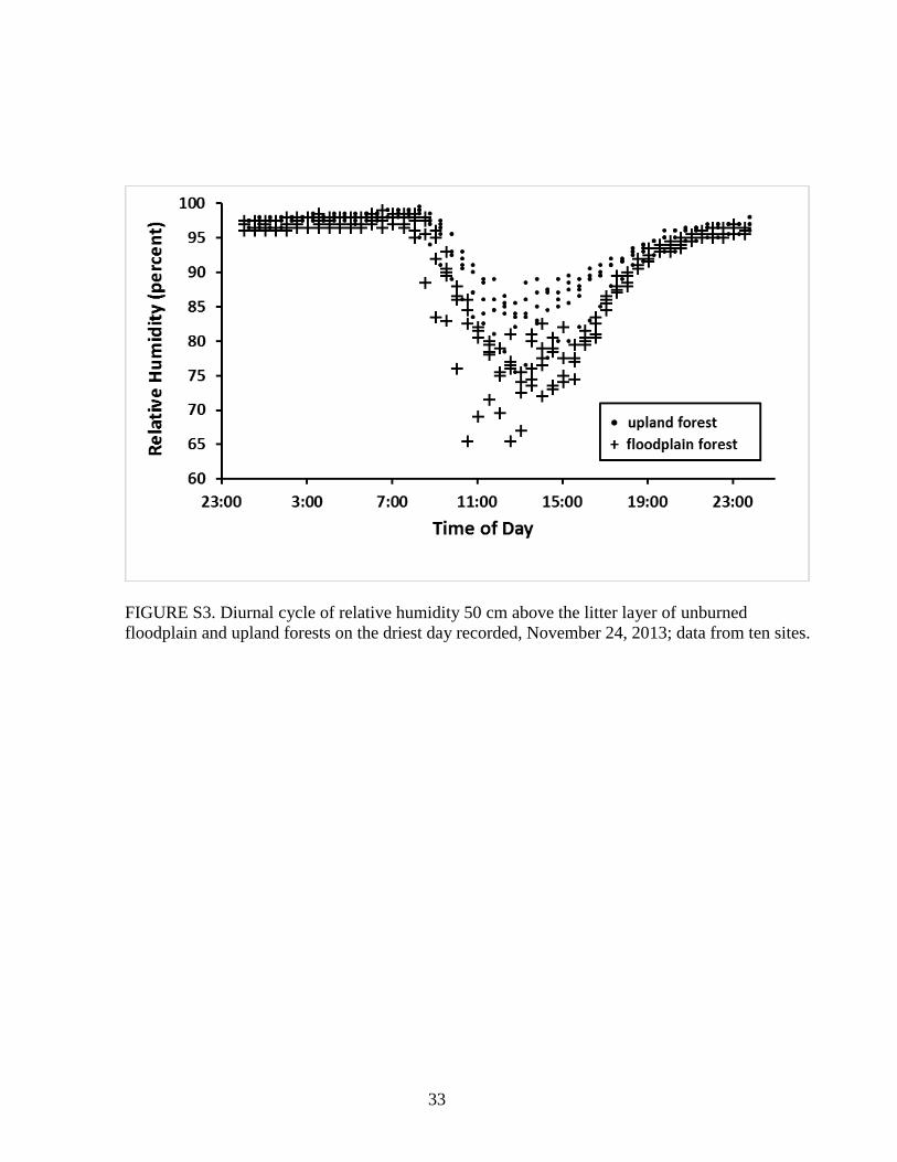
MICROCLIMATE. – The unburned flooded forest understory reached higher extremes of
temperature (p=0.008) and lower extremes of relative humidity (p=0.009) than unburned upland
forest. Among the five sensors in floodplain forest, the lowest one-percentile of humidity was in
the range 71-77 percent RH, compared to 81-87 percent RH for the five sensors in the upland
forest (Fig. 1C). Figure S3 shows a 24 h cycle for all sensors on the driest day of the 17-day

23
period, when one flooded forest site dropped briefly below the critical litter flammability level of
65 percent RH in the understory.
[Fig. 1 near here]
DISCUSSION AND CONCLUSIONS
It is clear from satellite images (Fig. S1) that fire spreads much more easily through seasonally
flooded forest and does greater damage there than in neighboring upland forest. At least three
factors contribute to this lower resistance: drier microclimate, higher fine fuel load and a root mat
in the flooded forest. Each one is discussed below.
The lowest one percentile RH cutoff for flooded forest understory was about 8 percent of RH
lower than for upland forest. Assuming this difference also occurs in years drier than 2013, the
flooded forest litter layer will be more flammable and flammable for longer periods than the
upland litter, as postulated in our second hypothesis. Tree basal area 26 percent lower than in
upland and tree stem density 40 percent lower (Table S1, Figure S2A) suggest more canopy gaps
and less total leaf area in the flooded forest. The upland forest has abundant understory leaves,
while flooded forest understory is very open. Forest types with greater light penetration, lower
height and fewer leaves attain the critical flammability level of 65 percent RH more days of the
year (Uhl et al. 1988, Holdsworth & Uhl 1997).
Dos Santos & Nelson (2013) found ~26 Mg/ha of fine fuel stock as litter and root mat in
nutrient-poor black-water flooded forests, about twice the amount in nearby upland forests. More
fine fuel combined with longer periods of flammability will lead to more and hotter burns during
drought years in the seasonally inundated forest than in the upland. Finally, the flammable root

24
mat makes flooded forest vulnerable to both surface fires and ground fires, with the latter killing
many more trees by burning their roots (Flores et al. 2014).
As on the nutrient-poor Rio Negro (Flores et al. 2014), the flooded forest at our site showed
low post-fire resilience. Woody regrowth was nearly absent 3-4 yr after a first fire. The burned
upland forest had a continuous canopy of surviving pre-burn trees or of dense regrowth (<10 cm
DBH) where the fire had formed gaps. Near-complete canopy removal combined with slow post-
burn recovery leaves the flooded environment dominated by low shrubs, forbs and graminoids for
many years, increasing the likelihood of reburning in subsequent dry seasons (Flores et al. 2014).
Despite this, ground fires were not mentioned as a cause of floodplain forest degradation or
loss in a recent review of threats to fresh-water Amazonian ecosystems (Castello et al. 2013). As
ignition sources spread with advancing human occupation, fire will become more frequent and
widespread, threatening loss of nutrient-poor flooded forest areas. Future directions for study
include understanding the underlying causes and consequences of low resistance to fire and of
low post-fire resilience in nutrient-poor floodplains; the role of fire in forest degradation of
nutrient-rich floodplains; and predicting and managing fire risk.
ACKNOWLEDGEMENTS
We thank Francisco Cavalcante (in memoriam), Pedro Gama, Livia Resende, João Rocha, Vilma
Soares, Maria Fernanda da Silva, Igor do Vale, Aline Lopes and Sebastião Salvino for field
assistance; the Correa family and Tiango Ribeiro for permission to work on their properties;
Milena Holmgren, Adrian Barnett, Maria Teresa Piedade, Jochen Schöngart and two anonymous
reviewers for revisions; FAPEAM (Amazonas Research Support Foundation) and CNPq

25
(Brazilian National Research Council) for financial support.
SUPPORTING INFORMATION
Additional Supporting Information may be found in the online version of this article:
FIGURE S1. Landsat Thematic Mapper image acquired in November of 2010, one year after
fire, showing high damage in dendritic flooded forests, low damage in intercalated upland
interfluves. Dashed line indicates approximate limit of fire front separating burned plots and
control plots.
FIGURE S2. (A) Comparison of stem density by size class between unburned upland and
floodplain; (B) Comparison of post-fire percent stem loss by size class. Error bars are ± two
standard errors of the mean.
FIGURE S3. Diurnal cycle of relative humidity 50 cm above the litter layer of unburned
floodplain and upland forests on the driest day recorded, November 24, 2013; data from ten sites.
TABLE S1. Tree basal area and density for 40 inventory plots.
LITERATURE CITED
ADIS, J., T. L. ERWIN, L. D. BATTIROLA, AND S.M. KETELHUT. 2010. The importance of
Amazonian floodplain forests for animal biodiversity: beetles in canopies of floodplain
and upland forests. In W.J. Junk, M. T. F. Piedade, F. Wittmann, J. Schöngart and P.
Parolin (Eds.). Amazonian floodplain forests, pp. 313–325. Springer, Dordrecht.

26
BARBOSA, R. I., AND P. M. FEARNSIDE. 1999. Incêndios na Amazônia brasileira: estimativa da
emissão de gases do efeito estufa pela queima de diferentes ecossistemas de Roraima na
passagem do evento “El Niño” (1997/98). Acta Amazon. 29: 513–534.
BARLOW, J., C. A. PERES, B. O. LAGAN, AND T. HAUGAASEN. 2003. Large tree mortality and the
decline of forest biomass following Amazonian wildfires. Ecology Letters 6: 6–8.
BARLOW, J., AND C. A. PERES. 2004. Ecological responses to El Niño-induced surface fires in
central Brazilian Amazonia: management implications for flammable tropical forests.
Philosophical Transactions of the Royal Society of London, B 359: 367–380.
BARLOW, J., AND C.A. PERES. 2008. Fire mediated dieback and compositional cascade in an
Amazonian forest. Philosophical Transactions of the Royal Society of London, B 363:
1787–1794.
CASTELLO, L., D. G. MCGRATH, L. L. HESS, M. T. COE, P. A. LEFEBVRE, P. PETRY, M. N.
MACEDO, V. F. RENÓ, AND C. C. ARANTES, 2013. The vulnerability of Amazon
freshwater ecosystems. Conservation Letters 6: 217–229.
COCHRANE, M. A., AND M. D. SCHULZE. 1999. Fire as a recurrent event in tropical forests of the
Eastern Amazon: effects on forest structure, biomass, and species composition. Biotropica
31: 2–16.
COCHRANE, M. A., A. ALENCAR, M. D. SCHULZE, C. M. SOUZA JR., D. C. NEPSTAD, P. LAFEBVRE,
AND E. A. DAVIDSON. 1999. Positive feedbacks in the fire dynamic of closed canopy
tropical forests. Science (Wash.) 284: 1832–1835.
COCHRANE, M. A. 2003. Fire science for rainforests. Nature 421: 913–919.
CORREA, S. B., K. O. WINEMILLER, H. LOPEZ-FERNANDEZ, AND M. GALETTI. 2007. Evolutionary
perspectives on seed consumption and dispersal by fishes. Bioscience 57: 748–756.

27
DOS SANTOS, A. R., AND B. W. NELSON. 2013. Leaf decomposition and fine fuels in floodplain
forests of the Rio Negro in the Brazilian Amazon. J. Trop. Ecol. 29: 455–458.
FLORES, B. M., M. T. F. PIEDADE, AND B. W. NELSON. 2014. Fire disturbance in Amazonian
blackwater floodplain forests. Plant Ecology and Diversity 7(1–2): 319–327.
GOULDING, M., M. L. CARVALHO, AND E. J. G. FERREIRA. 1988. Rio Negro, rich life in poor
water: Amazonian diversity and foodchain ecology as seen through fish communities.
SPB Academic, Amsterdam.
HAUGAASEN, T., J. BARLOW, AND C. A. PERES. 2003. Surface wildfires in central Amazonia:
short-term impact on forest structure and carbon loss. For. Ecol. Manage. 179: 321–331.
HOLDSWORTH, A. R., AND C. UHL. 1997. Fire in Amazonian selectively logged rain forest and the
potential for fire reduction. Ecological Applications 7(2): 713–725.
IRION, G., J. A. DE MELLO, J. MORAIS, M. T. F. PIEDADE, W. J. JUNK, AND L. GARMING. 2010.
Development of the Amazon valley during the middle to late quaternary:
sedimentological and climatological observations. In W.J. Junk, M. T. F. Piedade, F.
Wittmann, J. Schöngart and P. Parolin (Eds.). Amazonian floodplain forests, pp. 27–42.
Springer, Dordrecht.
KAUFFMANN, J. B., C. UHL, AND D. L. CUMMINGS. 1988. Fire in the Venezuelan Amazon 1: Fuel
biomass and fire chemistry in the evergreen rainforest of Venezuela. Oikos 53: 167–175.
MELACK, J. M., AND L. L. HESS. 2010. Remote sensing of the distribution and extent of wetlands
in the Amazon basin. In W.J. Junk, M. T. F. Piedade, F. Wittmann, J. Schöngart and P.
Parolin (Eds.). Amazonian floodplain forests, pp. 43–59. Springer, Dordrecht.
NELSON, B. W. 2001. Fogo em florestas da Amazonia Central em 1997. In: Proc. 10th Brazilian
Remote Sensing Symp., Foz do Iguaçu, Parana, Brazil pp. 1675–1682.

28
PERES, C. A. 1999. Ground fires as agents of mortality in a Central Amazonian forest. J. Trop.
Ecol. 15: 535–541.
UHL, C., J. B. KAUFFMAN, AND D. L. CUMMINGS. 1988. Fire in the Venezuelan Amazon 2:
environmental conditions necessary for forest fires in the evergreen rainforest of
Venezuela. Oikos 53: 176–184.
WITTMANN, F., J. SCHÖNGART, AND W.J. JUNK. 2010. Phytogeography, species diversity,
community structure and dynamics of Central Amazonian floodplain forests. In W.J.
Junk, M. T. F. Piedade, F. Wittmann, J. Schöngart and P. Parolin (Eds.). Amazonian
floodplain forests, pp. 61–102. Springer, Dordrecht.

29
FIGURE LEGENDS
FIGURE 1. (A) Stem loss in neighboring seasonally flooded and upland forests exposed to the
same fire; (B) basal area loss after same fire; (C) driest one-percentile of relative humidity
records for each sensor in understory of unburned flooded forest and unburned upland forest sites
over 17 days in the 2013 dry season.

30
FIGURES
Figure 1.

31
SUPPORTING INFORMATION
FIGURE S1. Landsat Thematic Mapper image acquired in November of 2010, one year after fire,
showing high damage in dendritic flooded forests, low damage in intercalated upland interfluves.
Dashed line indicates approximate limit of fire front separating burned plots and control plots.

32
FIGURE S2. (A) Comparison of stem density by size class between unburned upland and
floodplain; (B) Comparison of post-fire percent stem loss by size class. Error bars are ± two
standard errors of the mean.
33
FIGURE S3. Diurnal cycle of relative humidity 50 cm above the litter layer of unburned
floodplain and upland forests on the driest day recorded, November 24, 2013; data from ten sites.

34
TABLE S1. Tree basal area and density for 40 inventory plots.
Burned Flooded Forest
Burned Upland
Unburned
Flooded Forest
Unburned Upland
Plot BA/ha
% loss
BA Ind./ha
% loss
Ind. BA/ha
% loss
BA Ind./ha
% loss
Ind. Ba/ha Ind./ha Ba/ha Ind./ha
1
8.7 55 78 76 25.1 5 574 -5 18.7 252 27.3 620
2
13.1 32 206 37 25.1 5 332 39 24.4 396 26.6 520
3
10.2 48 154 53 21.0 20 528 3 15.7 318 28.9 502
4
3.1 84 54 84 23.5 11 354 35 15.0 236 28.9 564
5
6.3 68 110 67 22.7 14 518 5 26.6 350 22.6 504
6
12.3 37 196 40 21.4 19 524 4 16.9 292 24.6 556
7
11.6 40 234 29 16.2 39 406 26 19.9 310 25.0 556
8
3.9 80 78 76 15.8 40 372 32 15.8 270 27.2 508
9
11.8 39 190 42 18.2 31 518 5 21.8 480 31.5 528
10 2.8 86 48 85 18.4 30 442 19 19.4 384 21.0 602
Mean
8.4 57 135 59 20.7 21 457 16 19.4 329 26.3 546
SD
4.0 21 69 21 3.5 13 86 16 3.9 75 3.2 41
CV
0.5 0.4 0.5 0.4 0.2 0.6 0.2 1.0 0.2 0.2 0.1 0.1
Abbreviations: BA – Basal Area, Ind. – Number of Individuals, SD – Standard Deviation, CV – Coefficient of Variation.
Percent loss of basal area and of density (Ind./ha) calculated using average of unburned control plots as proxy for pre-burn values.

35
2. Conclusões
As cicatrizes de fogo com formas alongadas, seguindo os cursos dendríticos de florestas
alagáveis e parando nas suas cabeceiras sem cruzar para outra micro-bacia de drenagem (veja o
limite de incêndios desenhado na Figura S1) indicam que o fogo penetra mais nas florestas
sazonalmente inundáveis de igapó do que nas de terras firmes. Onde o fogo penetrou na terra
firme adjacente ao curso alongado de floresta alagável, o dano foi menor na terra firme. Pelo
menos três fatores contribuem para isso: (1) microclima do sub-bosque mais seco na floresta
inundável, (2) maior quantidade de material combustível fino e (3) a presença de um tapete de
raízes, expostas ao fogo, na floresta inundável. Possivelmente outras características relacionadas
à estrutura, morfologia e/ou fisiologia da floresta inundável e da terra firme também são fatores
responsáveis pelas condições de maiores temperaturas e menores umidades relativas no sub-
bosque de florestas alagáveis, aumentando a susceptibilidade a incêndios.
As florestas inundáveis são quase totalmente desprovidas de folhas verdes no sub-bosque
enquanto a floresta de terra firme abriga um denso sub-bosque. A transpiração e a evaporação de
folhas a partir de uma maior área de superfície molhada por orvalho podem umidificar e resfriar o
ar perto da serapilheira. O índice de área foliar e o fechamento do dossel também podem ser
diferentes entre os dois tipos florestais.
Os extremos mínimos de umidade relativa no sub-bosque da floresta inundável foram
cerca de 8 % inferiores aos extremos mínimos na floresta de terra firme. Assumindo que esta
diferença também ocorra em anos mais secos do que 2013, quando as medidas foram tomadas, a
camada de serapilheira na floresta inundável será mais inflamável por períodos mais longos,
como postulado em nossa segunda hipótese. Dos Santos & Nelson (2013) relataram que os
estoques de combustível fino superficiais em florestas de igapó (águas negras, pobres em
nutrientes), são maiores do que em florestas de terra firme. A serapilheira de textura fina foi
entremeada por um tapete bem aerado de raízes no igapó, enquanto em florestas de terra firme --
mesmo tendo solo mais arenoso, o tapete de raízes foi mais fino ou ausente (Dos Santos &

36
Nelson 2013). A queima do tapete de raízes contribui para a alta mortalidade de árvores no igapó
(Flores et al., 2012).
A lenta recuperação pós-queima deixa o ambiente inundável dominado por arbustos
baixos, ervas, Poaceae e Cyperaceae por muitos anos, aumentando a probabilidade de requeima
em estações secas subsequentes (Flores et al., 2012). Apesar disso, em uma recente revisão de
ameaças aos ecossistemas amazônicos de água doce, os incêndios de igapó sequer foram
mencionados como uma das causas da degradação ambiental (Castello et al., 2013).
As florestas de terra firme, quando não perturbadas, podem servir como barreira ao fogo
devido a sua menor inflamabilidade. Já as inundáveis, mesmo quando intactas, podem ser
inflamáveis se atingirem baixas umidades relativas, sofrendo, portanto, maior dano quando
atingidas por incêndios rasteiros. Com o avanço da ocupação humana as fontes de ignição
aumentaram, o que pode tornar os incêndios florestais em florestas sazonalmente alagáveis (e de
terras firmes) mais frequentes e generalizados.
Diante das conclusões geradas até aqui, estudos futuros devem ser direcionados para (1) a
compreensão das consequências da baixa resistência ao fogo e da baixa resiliência pós-fogo em
florestas inundáveis pobres em nutrientes, (2) o papel do fogo na degradação das florestas de
várzeas ricas em nutrientes, (3) a previsão e o controle dos riscos de incêndios e (4) o tempo
necessário para que cada tipologia possa se recuperar após incêndios.

37
3. Referências bibliográficas
BIERREGARD JR., R. O.; LOVEJOY, T. E.; KAPOS, V.; SANTOS, A. A.; HUTCHINGS, R.
W. The biological dynamics of tropical forest fragments. Bioscience. 42: 859 - 866, 1992.
CASTELLO, L., D., G. MCGRATH, L. L. HESS, M. T. COE, P. A.LEFEBVRE, P. PETRY, M.
N. MACEDO, V. F. RENÓ, AND C. C. ARANTES, The vulnerability of Amazon freshwater
ecosystems. Conservation Letters 6: 217-229, 2013.
COCHRANE, M. A.; ALENCAR, A.; SCHULZE, M. D.; SOUZA JR, C. M.; NEPSTAD, D. C.;
LAFEBVRE, P.; DAVIDSON, E. A. Positive feedbacks in the fire dynamic of closed canopy
tropical forests. Science. 284: 1832 - 1835, 1999.
COCHRANE, M. A. Synergistic interactions between habitat fragmentation and fire in evergreen
tropical forests. Conservation Biology. 15: 1515 – 1521, 2001.
COCHRANE, M. A. & LAURANCE, W. F. Fire as a large-scale edge effect in Amazonian
forests. Journal of Tropical Ecology. 18: 311 – 325, 2002.
DOS SANTOS, A. R., AND B. W. NELSON. Leaf Decomposition and Fine Fuels in Floodplain
Forests of the Rio Negro in the Brazilian Amazon. Journal of Tropical Ecology. 29: 455-458,
2013.
FEARNSIDE, P. M. Fire in the tropical rain forests of the Amazon Basin. In: Goldammer, J. G.
(ed.) Fire in the Tropical Biota: Ecosystem Processes and Global Challenges. Springer-Verlag,
Heidelberg, Germany, 106 – 116, 1990.

38
FLORES, B. M., M. T. F. PIEDADE, AND B. W. NELSON. Fire disturbance in Amazonian
blackwater floodplain forests. Plant Ecology and Diversity (doi:
10.1080/17550874.2012.716086). 2012.
JUNK, W. J. Flood tolerance and tree distribution in central Amazonia. In: HOLM-NIELSEN, L.
B.; NIELSEN, I. C.; BALSLEV, H. (eds) Tropical Forest Botanical Dynamics. Speciation and
Diversity, Academic Press, London, 47-64, 1989.
JUNK, Wolfgang J.; PIEDADE, Maria TF. An Introduction to South American Wetland Forests:
Distribution, Definitions and General Characterization. In: Amazonian Floodplain Forests, 3-25,
2011.
JUNK, W. J., PIEDADE, M. T. F., SCHÖNGART, J., COHN-HAFT, M., ADENEY, J. M., &
WITTMANN, F. (2011). A classification of major naturally-occurring Amazonian lowland
wetlands. Wetlands. 31(4): 623-640, 2011.
KAUFFMAN, J.B.; UHL, C.; CUMMINGS, D. L. Fire in the Venezuelan Amazon 1: Fuel
biomass and fire chemistry in the evergreen rainforest of Venezuela. Oikos. 53: 167 - 175, 1988.
MARENGO, J. A. In: MARENGO, J. A. Mudanças climáticas globais e seus efeitos sobre a
biodiversidade: caracterização do clima atual e definição das alterações climáticas para o
território brasileiro ao longo do século XXI, Brasília: MMA, 2006.
MARENGO, J. A.; TOMASELLA, J.; ALVES, L. M.; S.; WAGNER R.; RODRIGUEZ, D. A.
The Drought of 2010 in the Context of Historical Droughts in the Amazon Region. Geophysical
Research Letters, 38: L12703, 2011.
NASCIMENTO, H. E. M. & LAURANCE, W. F. Efeitos de área e de borda sobre a estrutura
florestal em fragmentos de floresta de terra-firme após 13 -17 anos de isolamento. Acta
Amazônica, Manaus, 36: 183 - 192, 2006.

39
NELSON, B. W. 2001. Fogo em florestas da Amazônia Central em In: Proc. 10th Simpósio
Brasileiro de Sensoriamento Remoto, Foz do Iguaçu, Paraná, Brasil. 1675-1682, 1997.
NEPSTAD, D. C.; VERISSIMO, A.; ALENCAR, A.; NOBRE, C.; LIMA, E.; LEFEBVRE, P.;
SCHLESINGER, P.; POTTERK, C.; MOUTINHO, P.; MENDOZA, E.; COCHRANE, M. &
BROOKS, V. Large-scale impoverishment of Amazonian forests by logging and fire. Nature.
398: 505 – 508, 1999.
PRANCE, G. T. A terminologia dos tipos de florestas amazônicas sujeitas a inundação. Acta
Amazônica. 10: 495 – 504, 1980.
SCHÖENGART, J., PIEDADE, M. T. F., LUDWIGSHAUSEN, S., HORNA, V., & WORBES,
M. Phenology and stem-growth periodicity of tree species in Amazonian floodplain
forests. Journal of Tropical Ecology, 18(4): 581-597, 2002.
UHL, C.; KAUFFMAN, J. B.; CUMMINGS, D. L. Fire in the Venezuelan Amazon 2:
Environmental conditions necessary for forest fires in the evergreen rainforest of Venezuela.
Oikos. 53: 176 - 184, 1988.
UHL, C.; KAUFFMAN, J. B. Deforestation, fire susceptibility, and potential tree responses to
fire in the eastern Amazon. Ecology. 71: 437 – 449, 1990.
WORBES, M., Growth rings, increment and age in inundation forests, savannas and a mountain
forest in the neotropics. IAWA Bulletin (Netherlands). 1989.