Crisis InformationÆ̧ Active Flames
Burnt Area (20/06/2017)General Information
Area of InterestClouds
Administrative boundariesProvince
Settlements! Populated Place
ResidentialAgriculturalCommercialIndustrialRecreationalOther
TransportationPrimary RoadLocal Road
Æ̧
!
!
!
!
!
!
!
!
!
!
!
!
!
!
!
!
!
!
!
!
!
!
!
!
!
!
!
!
!
!
!
!
!
!
!
!
!
!
!
!
!
!
!
!
!
!
!
!
!
!
!
!
!
!
Rua Carlos
Reis
Avenidado Brasil
Rua GeneralHumberto Delgado
Rua de Coimbra
Leiria
Coimbra
Cadaixo
Chapinha
Pegos
Espinho
Gondramaz
Vale deNogueira
Ceirados
Vales
Gândara
Chiqueiro
Vaqueirinho
Catarredor
Vilarinho
Candal
Cerdeira
Bolo
Pêra
Pisão doTeresa
Palheira
Botelhas
Coentral
Matas
Boiça
Portela
Pena
Povorais
Esporão
Galhardo
Vale de Neira
ForneaCacilhas
Freixo
Lousã
Casal Novo Talasnal
Sarnadas
Pisão doBaeta
Cabanões
Covas
Avessada
Codecais
Boavista
Albergaria
Aigra Nova
Comareira
Camelo
Ponte deSóltão
Aigra Velha
AmiosoCimeiro
Amioso doSenhor
8°9'0"W
8°9'0"W
8°12'0"W
8°12'0"W
8°15'0"W
8°15'0"W
8°18'0"W
8°18'0"W40
°6'0"
N 40°6
'0"N
40°3
'0"N 40
°3'0"
N
560000
560000
565000
565000
570000
570000
575000
575000
4435
000
4435
000
4440
000
4440
000
GLIDE number: WF-2017-000073-PRT
!(
!(
!(
Centro (PT)
Alentejo
BaixoVouga
BaixoMondego
PinhalInteriorNorte
Dao-Lafoes
PinhalInterior Sul
BeiraInteriorNorte
BeiraInterior
Sul
Cova daBeira
Medio Tejo
CasteloBranco
Guarda
Coimbra
Tajo
Mondego
Zezere
1 2 3
4 5 6
7 8 9
10^ Spain
PortugalNORTH
ATLANTICOCEAN
Lisbon
Cartographic Information
1:25000
±Grid: WGS 1984 UTM Zone 29N map coordinate system
Full color ISO A1, medium resolution (200 dpi)
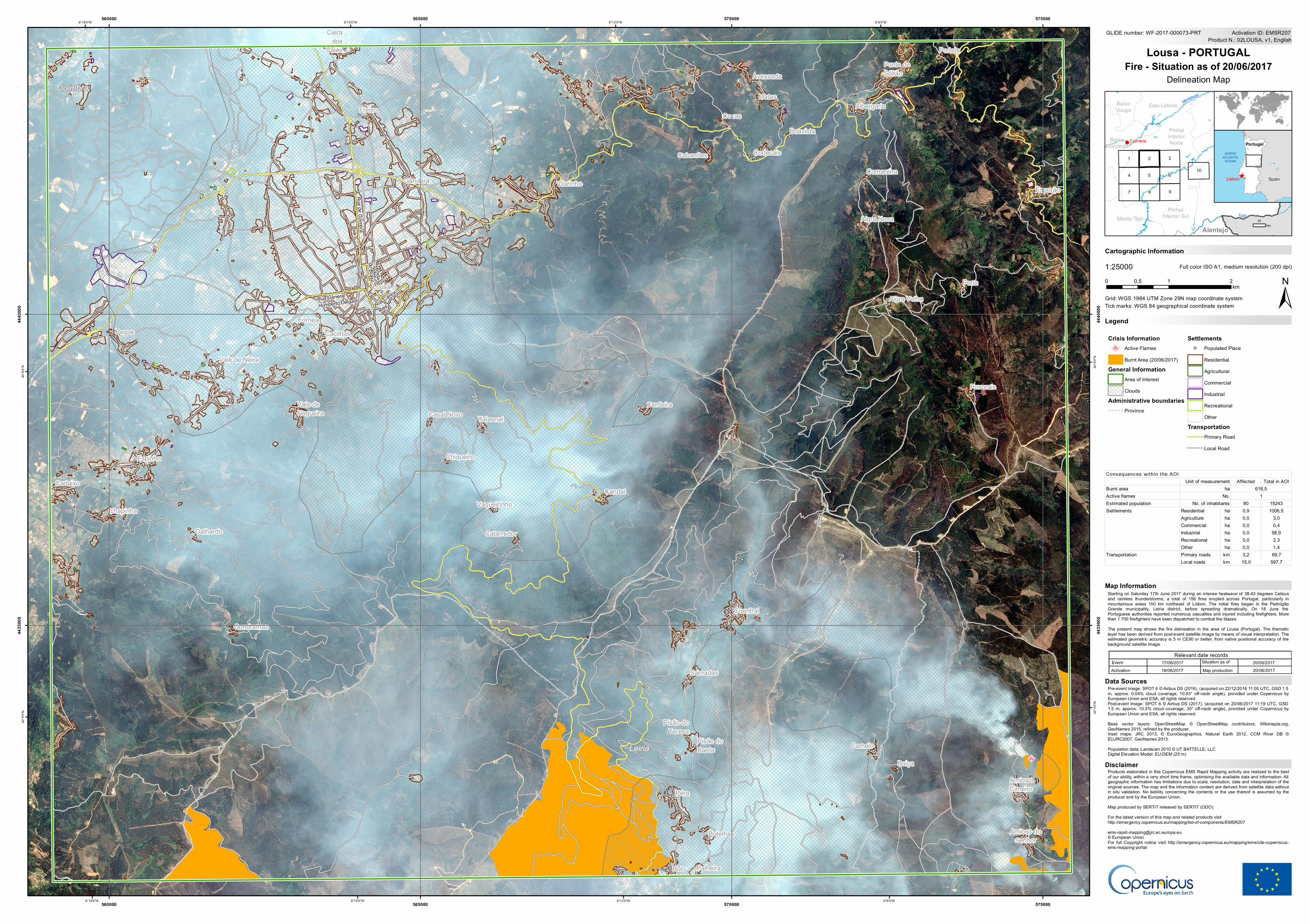
Starting on Saturday 17th June 2017 during an intense heatwave of 38-43 degrees Celsiusand rainless thunderstorms, a total of 156 fires erupted across Portugal, particularly inmountainous areas 150 km northeast of Lisbon. The initial fires began in the PedrógãoGrande municipality, Leiria district, before spreading dramatically. On 18 June thePortuguese authorities reported numerous casualties and injured including firefighters. Morethan 1 700 firefighters have been dispatched to combat the blazes.The present map shows the fire delineation in the area of Lousa (Portugal). The thematiclayer has been derived from post-event satellite image by means of visual interpretation. Theestimated geometric accuracy is 5 m CE90 or better, from native positional accuracy of thebackground satellite image.
Products elaborated in this Copernicus EMS Rapid Mapping activity are realized to the bestof our ability, within a very short time frame, optimising the available data and information. Allgeographic information has limitations due to scale, resolution, date and interpretation of theoriginal sources. The map and the information content are derived from satellite data withoutin situ validation. No liability concerning the contents or the use thereof is assumed by theproducer and by the European Union.Map produced by SERTIT released by SERTIT (ODO).For the latest version of this map and related products visithttp://emergency.copernicus.eu/mapping/list-of-components/[email protected]© European UnionFor full Copyright notice visit http://emergency.copernicus.eu/mapping/ems/cite-copernicus-ems-mapping-portal
LegendTick marks: WGS 84 geographical coordinate system
Product N.: 02LOUSA, v1, EnglishActivation ID: EMSR207
Pre-event image: SPOT 6 © Airbus DS (2016), (acquired on 22/12/2016 11:05 UTC, GSD 1.5m, approx. 0.04% cloud coverage, 10.93° off-nadir angle), provided under Copernicus byEuropean Union and ESA, all rights reserved.Post-event image: SPOT 6 © Airbus DS (2017), (acquired on 20/06/2017 11:19 UTC, GSD1.5 m, approx. 10.3% cloud coverage, 30° off-nadir angle), provided under Copernicus byEuropean Union and ESA, all rights reserved.Base vector layers: OpenStreetMap © OpenStreetMap contributors, Wikimapia.org,GeoNames 2015, refined by the producer.Inset maps: JRC 2013, © EuroGeographics, Natural Earth 2012, CCM River DB ©EUJRC2007, GeoNames 2013.Population data: Landscan 2010 © UT BATTELLE, LLCDigital Elevation Model: EU-DEM (25 m)
0 1 20,5km
Lousa - PORTUGALFire - Situation as of 20/06/2017
Delineation Map
Map Information
Relevant date recordsEvent Situation as of17/06/2017 20/06/2017Activation Map production18/06/2017 20/06/2017
Disclaimer
Data Sources
10km
Affected Total in AOIBurnt areaActive flamesEstimated population 80 15243
Residential ha 0,9 1006,5Agriculture ha 0,0 3,0Commercial ha 0,0 0,4Industrial ha 0,0 58,9Recreational ha 0,0 2,3Other ha 0,0 1,4Primary roads km 3,2 69,7Local roads km 15,0 597,7
Consequences within the AOIUnit of measurement
ha 618,5
No. of inhabitantsNo. 1
Settlements
Transportation
Recommended