Embed Size (px)
Citation preview
FOREST BIOMASS AND WOOD CONSUMPTION IN THE LOWER COURSE OF THE AMAZON: A CASE STUDY OF THE URUBUEUA ISLAND.
Akio TSUCHIYA1, Mario HIRAOKA2
ABSTRACT — Várzea and terra-firme forests in the lower course of the Amazon were compared in terms of forest structure, wood volume increments and forest biomass. The wood volume of várzea forests was smaller than that of terra-firme forests, particularly when severe human intervention such as the cultivation of açaí palm occurred. The difference was even greater in the forest weight comparison because of the lower wood density of várzea trees. These trees are not directly influenced by water stress during the dry season, while late wood with a high density is formed in the terra-firme trees. The annual forest disappearance area due to firewood for tile factories was estimated to be about 276 ha on the island investigated, which had an area of 36,200 ha. Assuming that the forests are rotatively cultivated every 25 to 30 years, the total deforestation area is 6,870-6,948 ha in 25 years and 8,244~8,337 ha in 30 years. This result means that the balance between forest biomass and utilization is not in crisis, however, this balance might be lost as long as substitutive energy such as electricity is not supplied.
Key words: açaí (Euterpe oleracea), Amazon estuary, deforestation, firewood, terra-firme, tile factory, várzea.
Biomassa Florestal e Consumo Madereiro na Foz do Amazonas: Um Caso de Estudo na Ilha Urubueua.
RESUMO — Florestas de várzea e de terra-firme na foz do Amazonas foram comparadas, com relação à sua estrutura, incrementos de volume madeireiro e biomassa florestal. O volume madeireiro de floresta de várzea é menor que o de florestas de terra-firme, especialmente quando se considera a intervenção humana (o cultivo da palmeira açaí) na referida análise. Esta diferença é ampliada na comparação de peso florestal, pelo fato das árvores de várzea apresentarem uma baixa densidade madeireira. As árvores de florestas de várzea não são diretamente influenciadas pela escassez característica do período prolongado de seca, devido a madeira de alta densidade ser formada em árvores de terra-firme. Na ilha em estudo, cuja área é de 36.200 ha, o desaparecimento anual da área florestal devido às queimadas provocadas pelas olarias, é cerca de 276 ha. Assumindo-se que as florestas têm um período de rotação de 25 a 30 anos, a área total deflorestada está entre 6.87-69480 ha/25 anos a 8.244-8.337 ha/30 anos. Este resultado demonstra que o balanço entre a biomassa e sua utilização não está em crise; entretanto este balanço pode sofrer alterações, caso não sejam substituídos os meios de produção de energia na região.
Palavras-chave: açaí (Euterpe oleracea), foz do Amazonas, desflorestamento, lenha, terra-firme, várzea.
1 Faculty of Integrated Arts and Sciences, Hiroshima University, Hiroshima, Japan 2 School of Humanities and Social Sciences, Millersville University, PA, U.S.A.
INTRODUCTION
The Amazon, whose river basin is about 5,000,000 km 2, gathers rainfall from the eastern slope of the Andes, Amazon Basin, Guiana Highlands and Brazilian Plateau, and reaches the Atlantic Ocean (Sioli, 1984). The floodplain,
which is inundated by seasonal and diurnal fluctuations of fresh water, occupies about 150,000 km 2, and the flooded forest is locally called várzea. In várzea, a huge amount of fresh water is pushed back by the tidal activity twice a day, and the lowlands are periodically inundated. (Soares, 1991). Also, there is

another type of forest, which is found on land 7-8 m higher in altitude and is thus never flooded: it is called terra-firme (Bohrer & Gonçalves, 1991).
In the past, local people in the mouth of the Amazon have made a living by collecting forest products such as fruits, rubber, firewood and gold dust (Anderson, 1988). Recently, however, forest utilization has been accelerated by the influence of a monetary economy and the population growth of the Belém metropolitan area. Exploitation of forest products itself is growing (Anderson, 1991), and the people tend to mass-produce cash crops which are easily cultivated after logging trees. The logging is also increasing for firewood production. As a result, biodiversity in the estuary of the Amazon is in crisis (Mueller, 1983; Anderson & Ioris, 1992).
As mentioned above, the forests in the estuary are heavily influenced by human activities, and the degree is especially strong in the case of várzea. However, forest ecology studies which directly dealt with such secondary forests are quite few. For this reason, it is important to evaluate the present situation of these forests. The purpose of this study is to estimate the biomass of the two types of forests; várzea and terra-firme, growing in different environments. Then, the biomass is compared to wood consumption at tile factories (olaria), which is a representative industry there. Finally, the deforestated area will be estimated.
RESEARCH AREA
An enlarged figure of the Amazonian tidal floodplain is shown in Figure 1. Belém is located where the Pará River flows into the Atlantic
Ocean. A small city, Abaetetuba, is located 60 km to the southwest. A research site was set up along the Maracapucu Miri River on Urubueua Island across from Abaetetuba (Fig. 1). The island itself is made of alluvial deposits of the Amazon. Annual rainfall exceeds 2,500 mm in this region (Nimer, 1972). According to the climatological water balance in Belém, the rainy season is limited to January to July (Fig. 2). In this calculation, it is hypothesized that when the soil moisture exceeds the water holding capacity of the soil (150 mm/ m), the ground surface water begins to overflow as water surplus (Thornthwaite & Mather, 1955). When the dry season starts in August, the actual-evapotrans-piration exceeds rainfall until December. In fact, about 300 mm of water deficit appears during this period.
Seasonal fluctuation in water level along the Tocantins River is shown in Figure 3 (regarding the locations, refer to Fig.l). Although the range between the rainy and dry season reaches more than 10 m in Tucurui, an upper site, it becomes smaller in the lower course (e.g. Nazaré dos Patos and Baião), and it becomes smaller than 2 m in the research site. On the other hand, the diurnal change becomes dominant as shown in the lower part of Figure 3. This change is brought about by tidal activities. On a night with a full moon in January to February, for example, at the research site, a further 3m is added to the 2.7 m shown in the figure. Várzea is predominant on both sides of netted tributaries with 100 to 200 m width, and is influenced by the diurnal change of water level. In places a few meters


10 11 Month
Figure 2. Monthly water balance in Belém calculated by Thornthwaite and Mather's method. Statistical period is 20 years from 1968 to 1987.
higher than the várzea, however, terra-firme forests whose species composition is totally different predominate because the river water does not reach that forest level (Ayres, 1993).
STUDY METHODS
Fieldwork was carried out in 1993 and 1994. The research sites were set up in várzea along the Maracapucu Miri River and in terra-firme about 4 km from the várzea site as shown in Figure 1. Four 400 m 2 quadrats were set up in each site. They are called VZ1, VZ2, VZ3, VZ4 in várzea, and TF1, TF2, TF3, TF4 in terra-firme. Tree height and the diameter at breast
height (DBH) were measured in VZ1 to VZ3 and TF 1 to TF3 quadrats, and tree disks at the height of 1 m were taken by a chainsaw in VZ4 and TF4. Trees whose DBH was smaller than 5 cm were excluded. Disk samples for stem analysis were taken in 1994 from seven tree species at intervals of 1 to 2 m from the bottom to the top of the stem. They were cut to a thickness of 10 cm, and were brought to the laboratory after drying to stop mold development. They were polished on both surfaces using sandpaper attached to a grinding machine (paper grades: #40 and #100). The tree-ring widths of both the long and short diameter of

Figure 3. Seasonal water level change in Tucurui, Nazaré dos Patos, and Baião at the Tocantins river systems (upper), and an example of diurnal change of water depth in Maracapucu Miri River (lower). Regarding the locations, refer to Figure 1.
disks were measured by a microscope to an accuracy of 0.001mm (Nikon, MM-22). The average were regarded as the tree-ring width for the year. For the wood density measurement, 11 and 13 of the most frequently occurring tree species were selected from VZ4 and TF4, respectively, and the density was measured by a densimeter (Mirage Trading, EV-120SG) after removing the bark and drying the wood in an oven for 72 hours at 90°C (Yamato,
DV-400). The disks taken in quadrats VZ4 and TF4 were used to measure the reflected brightness spectrum using a Nexus Qube-9000 image analysis system. The brightness across the radius of the tree disk was measured for R, G, and B and rated 0 to 255. Of these three, the component G which reacts most sharply to brightness change was used to compare the difference between tree-ring formation in the early and late woods.

Questionnaire surveys at 10 tile factories along the Maracapucu Miri River and Furo Maracapucu River were carried out in 1995. The following were investigated: annual, seasonal, and monthly production, how the clay is obtained, how it is processed, the burning procedure, how firewood is obtained, tree species, tree size, firewood consumption, price of a piece of tile, genuine profit, work force, and foundation year.
RESULTS
Human intervention and forest structure
According to the landowners of the várzea and terra firme sites, about 30 years had passed since the last clear cutting in both sites, and in this area, the forest is usually clear cut every 25 to 30 years in order to sell the trees. This is found out by the number of tree rings: the percentage of the trees older than 30 years was 3% in VZ1, 7% in VZ2, 0% in VZ3, 6% in TF1, 5% in TF2, and 8% in TF3. The forest age has already reached the next time for clear cutting.
In várzea forests, the açaí palm (Euterpe oleracea) is extensively cultivated as noted by Anderson (1988) and Hiraoka (1992, 1993). This palm is the most important cash crop in the Amazon estuary (Brabo, 1979). After mashing the flesh, it is made into a drink, and the growing point (palmito) is processed as food. The açaí is cultivated within várzea forests by planting seedlings. Many trunks grow from one açaí, but they are continually cut down to promote the growth of the juvenile trunk
until the age of 5 to 10 years which brings maximum yield. Unnecessary trees and branches are also cut to manage the açaí palms. The three várzea quadrats have different degrees of forest management: the VZ1 has little human impact because only 11 açaí palms appear in 400 m2, the VZ2 has a medium disturbance (açaí: 42/400 m 2) and the VZ3 has a strong one (açaí: 83/400 m2). On the other hand, terra-firme forests are not intesively utilized except for rotatively developing small crop fields to cultivate manioc (Manihot utilissima) for domestic use.
Figure 4 shows the number of individuals in each tree species which appeared in quadrats VZ1 to VZ3 and inTFl to TF3. There is little difference in total population and the number of tree species in terra-firme quadrats, while the population greatly varies in várzea quadrats and the tree species are smaller than terra-firme. The total number of tree species was less than 10 in várzea, and about half of individuals were only a single species (Pterocarpus amazonicus, local name: Mututi-da-várzea). The number of trees seems to be dependent upon the degree of açaí cultivation, and the small number of tree species is caused by the inundation condition of várzea. On the other hand, in TF2, 27 species appear, and the total population is 80. Palms such as açaí do not exist in TF2. Instead, a thorny palmaceous plant called inajá (Maximiliana regia) whose height does not exceed two meters covers the forest floor. The forest structure was compared by using the number of trees as they appeared in each tree height class (Fig. 5). Trees up to the 25 m class appear in várzea, but trees taller than 25 m do not exist. In terra-firme, the high-

Várzea VZ1 VZ2 VZ3
V 1 3 5 7 9 11 13 15 17
2 4 6 8 10 12 14 16 18 19 21 23 25 27
20 22 24 26
Tree Species
19 21 23 25 27 20 22 24 26
VZ1: 1 Pterocarpus amazonicus, 2 Pachira acuatica, 3 Vatairea guianensis, 4 Virola surinamensis, 5 Avicennia nitida. 6 Mangifera indica. 7 Margaritaria nobilis, 8 Caryocar villosum VZ2: 1 Pterocarpus amazonicus, 2 Pachira acuatica, 3 Vatairea guianensis, 4 Uangitera indica, 5 Symphonia gloulHera, 6 Avicennia nitida, 7 Duroia macrophylla, 8 Wrote surinamensis, 9 Margaritaria nobilis, 10 Zyy/.i sp. VZ3: 1 Pterocarpus amazonicus, 2 Hevea brasiliensis, 3 Virola surinamensis. 4 Pachira acuatica, 5 Pentaclethra macroloba, 6 Margaritaria nobilis
Tree Species
individuals in each tree species in várzea and terra firme quadrats of an area of 400m 2 .
TF1: 1 Vochysia vismiaclolia, 2 Goupia glabra, 3 Gustavia augusta, 4 Triplaris surinamensis, 5 Eschweilera amazônica. 6 Tapirira guianensis. 7 Emmotum tagifolium, 8 Manilkara amazônica, 9 Acacia poly phyla, 10 Apeiba burchelli, 11 Aspidosperma eteatum, 12 Duguettia caulitlora. 13 Duroia macrophylla, 14 Iryanthera sagotiana, 15 Sagotia racemosa, 16 Sterculia speciosa, 17 Sterculia elata, 18 Buchenauia sp., 19 Undefined ( J e n c i r a ) , 20 Erisma uncinatum TF2: 1 Hymenaea intermedia, 1 Vochysia vismiaefolia, 3 Triplaris surinamensis, A Gustavia augusta, 5 Platonia insignis, 6 Eschweilera amazônica, 7 Manilkara amazônica, 8 Clidemia hirta, 9 Poragueiba guianensis, 10 Ormosia coutinhoi, 11 Swartzia racemosa. 12 Erisma uncinatum, 13 Acacia polyphyila, 14 Pachira acuatica, 15 Didymopanax morototoni, 16 Duguettia caulHlora, 17 Duroia macrophylla, 18 Goupia glabra, 19 Guarea kunthiana, 20 Mora paraensis, 21 Simaruba amara. 22 Sterculia pilosa, 23 Tapirira guianensis, 24 Tovomita cephalostigma, 25 Vouacapoua americana, 26 Sterculia elata, 27 Buchenauia sp. TF3: 1 Eschweilera amazônica, 2 Vochysia vismiaefolia, 3 Myrcia falax, 4 Duguettia caulHlora, 5 Undefined (Cama), 6 Triplaris surinamensis, 7 Hymenaea intermedia, 8 Humiria balsamitera, 9 Pachira acuatica, 10 Gustavia augusta, 11 Duguettia tlagelaris, 12 Britoa acida, 13 Guarea kunthiana, 14 Iryanthera sagotiana, 15 Pipthecellobium decandrum, 16 Simaruba amara, 17 Undefined (Azulando), 18 Clidemia hirta

cT 10 20 30 40
Number of Individuals Várzea Terra Firme
Figure 5. Comparison of the number of trees in each height class between várzea and terra-firme quadrats. The number is the average of 3 quadrats.
est class reaches 30 m. As far as the dispersion of classes is concerned, trees are uniformly distributed in várzea, while they seem to be divided into two classes in terra-firme; up to 10 m or more. This difference is also due to the fact that juvenile trees are cut down in várzea.
Wood volume increments
Tree species obtained for stem analysis are as follows (a) from the várzea: Pachira acuatica, Vatairea guianensis, Pterocarpus amazonicus, Virola surinamensis, and (b) from the terra-firme: Goupia glabra, Triplaris surinamensis, Vochysia vismiaefolia. Using the tree-ring width data of these tree species, annual wood volume increments were calculated by means of a
formula of sectional integration, regarding the stem shape as a cone shaped truncated body (Osumi et ah, 1983).
Annual change of wood volume increments is shown in Figure 6. It seems that the increments themselves are regulated by whether the forest is composed of trees of the forest canopy or understory. For example , P. amazonicus, whose tree height is 20.5 m and T. surinamensis (23. lm) are the canopy species (Rodrigues, 1989), and their annual increments are larger than those of the other tree species in the understory. However, the pattern of annual fluctuation is quite similar although the tree age, height and species are all different among the trees investigated. Figure 7 shows the annual

£ o
CO
o
<D E 3 O > T3 O O 5
P.acuatica
V.guianensis
P.amazonicus
V.surinamensis
25
10
Terra Firme
m-ã n a V — i 1 » 1—fVl'^t-T i 1 1 r — i [ r T ~
G.glabra
T.surinamensis —fe-í—
V.vismiaefolia
1966 1968 1970 1972 1974 1976 1978 1980 1982 1984 1986 1988 1990 1992 1994
Year Figure 6. Annual wood volume increments of 4 tree species of várzea and 3 species of terra firme forest.
changes of wood volume index (WVI) and the normalized precipitation in Belém. The WVI was calculated by the ratio between the actual wood volume and the three year running mean, and precipitation was filtered by a simple standardization method so that the average was zero and the standard deviation was one. The relationship between WVI and precipitation is quite clear. It shows that the WVI increases in the years when the water condition is satisfactory, and it decreases in dry years.
For example, in 1979,1981, 1983 and 1991, when the precipitation was less than the average, the WVI tends to be small. On the other hand, the WVI exceeds 100 in rainy years such as 1988 when the annual precipitation reached 3,920 mm.
Trees of terra-firme stop the growth of early wood when the dry season arrives in July and late wood growth begins due to increased water stress. Therefore, the tree-ring chronology has the same phase as the annual precipita-

c .2 "•4-* (O *j Q_ O <D i—
CL
"O <D N
"CÕ
E i -o z:
o o
s
o E o > T3 O O 5
2 0 0
Várzea Várzea 1 6 0 -
1 4 0 -
1 2 0 - * ft
8 0
Rn o u
2 0
n
P.acuaíica
V.guianensis
P.amazonicus
V.surinamensis
G.glabra
T. surinamensis —
V.vismiaetolia
1 9 6 5 1 9 6 7 1 9 6 9 1971 1 9 7 3 1 9 7 5 1 9 7 7 1 9 7 9 1 9 8 1 1 9 8 3 1 9 8 5 1 9 8 7 1 9 8 9 1991 1 9 9 3 1 9 9 5 1 9 6 6 1 9 6 8 1 9 7 0 1 9 7 2 1 9 7 4 1 9 7 6 1 9 7 8 1 9 8 0 1 9 8 2 1 9 8 4 1 9 8 6 1 9 8 8 1 9 9 0 1 9 9 2 1 9 9 4
1 9 6 5 1 9 6 7 1 9 6 9 1 9 7 1 1 9 7 3 1 9 7 5 1 9 7 7 1 9 7 9 1981 1 9 8 3 1 9 8 5 1 9 8 7 1 9 8 9 1991 1 9 9 3 1 9 9 5 1 9 6 6 1 9 6 8 1 9 7 0 1 9 7 2 1 9 7 4 1 9 7 6 1 9 7 8 1 9 8 0 1 9 8 2 1 9 8 4 1 9 8 6 1 9 8 8 1 9 9 0 1 9 9 2 1 9 9 4
Year Figure 7. Annual wood volume index and normalized precipitation in Belém.
tion. Trees of várzea are inundated twice a day even in the dry season. For this reason, they are not directly influenced by water stress. During the dry season, however, the number of hours when the water does not cover the forest floor becomes longer because the water level itself drops. Consequently, indistinct late wood growth occurs in the trees of the
várzea. Figure 8 is an example of a reflected brightness curve within a tree-ring (component G). The upper curve is for P. acuatica of the várzea, and the lower one is for T. surinamensis of the terra-firme. The brightness spectrum of P. acuatica is comparatively larger and the shape is flat because large cells are mainly formed due to small water stress.

Várzea: Pachira acuatica O 255
Annual Growth Ring Width (mm)
CD 255
c o c o o. E o O (/3 </3 O C -*-" H U} "C CQ
Terra Firme: Triplaris surinamensis
Annual Growth Ring Width (mm)
Figure 8. Reflected brightness curve of component G in a tree-ring of Pachira acuatica, an example of tree species of várzea, and Triplaris surinamensis, an example of terra-firme.
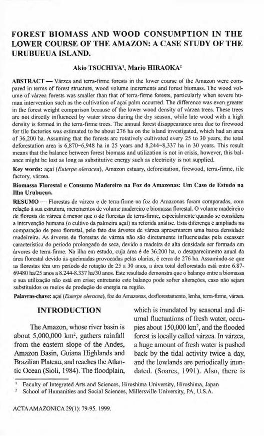
In the latter case, however, the spectrum drastically decreases in the second half. This is due to the late wood with small cells, and the formation was brought about by water stress during the dry season. This kind of change was seen in every tree-ring of all the tree species of terra-firme.
Forest biomass
The aboveground biomass can be estimated by directly weighing all invididuals in a site or from an allo-metric equation of DBH and tree height. The former method is limited to research groups in Brazil because it needs a large number of people and takes a long time, and results in the Amazon estuary have not been reported. Using the latter method, Auer (1993) found allometric equations for 13 tree species represented in the product of the square of DBH by tree height, but it is almost impossible to cover all species within the site due to the great number of species. Therefore, we used the allomeric equation
suggested by Higuchi et al. (1994). They showed that biomass estimates for Amazonian tropical forests were largely different among researchers, and the difference has brought about controversies in the estimate of deforestation area. They reexamined the forest inventory data and mathematical models, and were lead to the conclusion that the following equation and coefficients were the most reliable;
ln(WF) = -2.4768 + 2.230 lln(D) + 0.65181n(H) (5 cm =< D < 20 cm)
ln(WF) = -3.8102 + 1.4631 ln(D) + 1.81901n(H) (D >= 20 cm)
Here , WF: fresh weight , D: DBH, H: tree height.
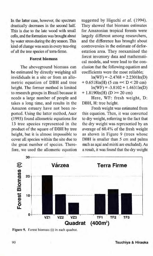
Fresh weight was estimated from this equation. Then, it was converted to dry weight, referring to the fact that the dry weight was represented by an average of 60.4% of the fresh weight as shown in Figure 9 (trees whose DBH is smaller than 5 cm and palms such as açaí and miriti are excluded). As a result, it was found that the dry weight
VZ1 VZ2 VZ3 TF1 TF2 TF3 Quadrat (400m2)
Figure 9. Forest biomass (t) in each quadrat.

at terra-firme sites showed almost the same value (11.56t/400 m 2 on average), while the weight greatly differed from 6.01 t at VZ3 to 20.43 t at VZ1 (av.: 12.30 t/400 m 2). This is because of the impact of different degrees of human intervention due to the cultivation of açaí. The data show that the total weight of VZ1 with little human impact is larger than those of terra-firme quadrats, but the value becomes less than one-third in such strongly disturbed quadrats as VZ3. Also, the result shows that the growth of trees in várzea is larger than terra-finne if forest management does not occur in várzea, considering these 6 quadrats have almost the same forest age.
DISCUSSION
Wood consumption at tile factories
In the Amazon estuary floodplain, a huge number of trees are consumed for tile factories. There are about 50 tile factories along the Maracapucu Miri River and Furo Maracapucu River where fieldwork was carried out, and the number amounts to 260 for overall Urubueua Island. According to Hiraoka (1993), tile production has become one of the main local industries since 1975 because (1) abundant trees can be utilized as fuel, (2) alluvial soil necessary for tile production accumulates at the depth of about 2m below the riverbeds, (3) the demand for roof tiles is increasing due to the growth of Belém.
Tile production begins by purchasing clay and firewood. Both of these are traded in units known as corda. One corda of firewood has about 18 (vertical) x 9 (horizontal) lengths of thumb
to middle finger when a man opens his hand (3.6 x 1.8 m on average), and the mean wood length is 1.5 m. The total volume of one corda firewood is about 9.72 m 3. After cutting the clay into a tile pattern and drying it, the tile is fired within a kiln using the following procedures: the first is to bake it at low temperature for 2 nights using várzea tree species as fuel (esquentar), the next step is to bake it at high temperature for 12 hours using terra-firme tree species (queimar), and then, they are cooled for one night after putting out the fire. Finally, they are taken out from the kiln to cool again for 3 days. The reason trees of várzea and terra-firme are selectively used is that várzea species do not reach high temperature, while trees of terra-firme have a high caloric value.
Taking an average, the number of tree species packed as a corda were 24 várzea and 16 terra-firme. The combination between várzea and terra-firme species is decided by lumbermen, but in general, 80 to 85% of one corda's wood volume is várzea species, and the remaining 15 to 20% is terra-firme species. Also, it was found from the questionnaire that firewood of 530.6 cordas (5,157.83 m 3) was consumed for producing 1,333,500 tiles in a year. When evaluating the firewood weight used in the factories, using the composition ratio between várzea and terra-firme species within a corda (80-85%: várzea, 15-20%: terra-firme) and the mean wood density of each forest (0.61 g/cm3: várzea, 0.70 g/cm 3: terra-firme), it reached 3,216 to 3,239 t.

The balance between forest biomass and wood consumption
The mean wood weight of várzea quadrats VZ1 to VZ3 is 12.30 t/400 m2, and is 11.561/400 m 2 in terra-firme quadrats TF1 to TF3. However, the weight is greatly different in the case of várzea quadrats. The wood weight of VZ1 is 20.43 M 400 m2, while the wood weight of VZ3 is only 6.01 1/400 m 2. Using these data and the annual firewood composition, it is possible to estimate the annual area of forest disappearance by cutting trees for tile factories. Figure 10 is the deforestation area which was estimated from the weight of firewood used. Converting the firewood volume (5,157.83 m3) into weight by making the firewood composition change from
VZ100TF0 (tree species of várzea: 100%, tree species of terra-firme: 0%) to VZ0TF100 (várzea: 0%, terra-firme: 100%), and considering the large variation of population density in várzea quadrats, the area was estimated in 12 cases. As a result, the area is 10.23 to 12.49 ha in case of normal várzea (VZMed), 6.16 to 12.49 ha in case of várzea with little disturbance (VZMax), and 20.94 to 12.49 ha when a strong human impact is added to várzea (VZMin). Várzea forests such as VZMax and VZMin are spacially limited, and it is unlikely that all the cordas are composed only from várzea or terra-firme tree species. Therefore, it is thought that the most likely case is 10.57 to 10.69 ha/year.
The area of Urubueua Island is 36,200 ha, and the total number of tile
VZ1O0TF0 VZ85TF15 VZ80TF20 VZ0TF100
Combination (VZ%TF%) Figure 10. Annual area of deforestation (ha) estimated from total weight of firewood at 10 tile
factories. VZMin means that the human impact on várzea forest is small like quadrat VZ1, VZMed is a normal várzea like VZ2, and VZMax is a forest with a strong human impact like VZ3.

facotries is 260. Also, it is said that the forest is rotatively developed every 25 to 30 years. Then, regarding 80 to 85% of firewood as várzea tree species, and considering the human impact to be medium degree, the abovementioned estimates were extended to the island scale (Tab. 1). In the former estimate (rotation: 25 years), the forest disappearance is 6,870 to 6,948 ha, and in the latter estimate (rotation: 30 years), it is 8,244 to 8,337 ha. Even though all the lumber comes from within the island, the deforestation area is less than a quarter of the whole island. Therefore, it is thought that the forest resources are not exhausted, and the forest growth and utilization are well balanced at present here in this island.
Table 1. The area of forest disappearance (ha) enlarged to the whole island. The upper case is the area in which the rotation of forest development occurs every 25 years, and the lower one is the same but for 30 years.
VZ85TF15 VZ80TF20
25 years 6,870 ha 6,948 ha
30 years 8,244 ha 8,337 ha
However, lumber utilizatiton is not only for the fuel at tile factories. Terra-firme tree species are prefered as construction materials for houses, ships and funiture although the concrete amount was not investigated at this time. Várzea species are also used for everyday cooking. If Belém's economic influence becomes stronger, the lumber consumption at Urubueua Island will increase, and it might make the forest disappear more than estimated above as long as electric energy is not diffused. Particularly, the problem is that the trees of várzea are
mainly cut for firewood production in this region. It is necessary to shift the present logging style to the utilization of tree species of terra-firme with higher wood densi ty which are thought to be more suitable as fuel (Peres & Dourado, 1986).
CONCLUSION
In this study, two types of secondary forests in the Amazon estuary were compared in terms of forest structure and biomass. Then, the area of deforestation by human activities was estimated. The following results were found: (1) In the lower course of the Amazon, there is a dry season during August to December. Therefore, unlike the várzea forest which repeats inundation, trees in terra-firme are directly influenced by water stress, which appears in the tree-ring formation and the wood density. (2) Açaí palm is cultivated in várzea forests. Vertical stratification is not seen in tree heights. On the other hand, terra firme forests are divided into two height classes, and the canopy layer is taller than that of the várzea. If the várzea forest is left without disturbance, the aboveground biomass exceeds that of the terra-firme forests. In actual cases, however, the biomass is dependent upon the degree of açaí cultivation, and is generally smaller than that of terra-firme forest. (3) Based on the forest biomass data and wood consumption at tile factories, the annual area of deforestation was tentatively estimated. As a result, it was smaller than 1 lha. When extending the area to the whole island, considering the rotative deforestation period, it was about 6,870 ha/25 years to 8,340 ha/30 years.

ACKNOWLEDGEMENTS
We would like to express our sincere gratitude to Mr. Pedro Alberto Moura Rolim at the Hydroclimatology and Remote Sensing Research Center, SUDAM and Professor José Carvalho de Moraes at Universidade Federal do Pará for providing us with climatic data. Mr. Carlos Rosário da Silva at the Department of Botany, MPEG assisted us in identifying tree species. Finally, this study was supported by the National Science Foundation, Ford Foundation, Heinz Foundation in the U.S. and Showa Shell Sekiyu Foundation in Japan.
Literature cited Anderson, A. B. 1988. Use and management of
native forests dominated by açai palm (Euterpe oleracea Mart.) in the Amazonian estuary. In: Balick M.J. (ed.) The palm-tree of life. New York Botanical Garden, New York, pp. 145-154.
Anderson, A. B.; Ioris E. M. 1992. The logic of extraction: resources management and income generation by extractive producers in the Amazon estuary. In: Redford K.H.; Padoch C. (eds.) Conservation of neotropical
forests. Columbia University Press, New York, pp. 175-199.
Anderson, S. D. 1991. Engenhos da várzea: uma analise de declino de um sistema de produção tradicional na Amazônia. In: Lena P.; Oliveira A.E. (eds.) Amazônia, a fronteira agrícola 20 anos depois. Museu Paraense Emílio Goeldi, Belém, pp. 101-121.
Auer, B. 1993. Allometric equation for 13 native tree species of the Amazonian estuary flood-plain. School of Forestry and Environmental Studies, Yale University, Tropical Resources Institute Working Paper, 1-18.
Ayres, J. M. 1993. As matas.de várzea do Mamiraua, médio Rio SolimÕes. Sociedade Civil Mamiraua, Tefé, 123p.
Bohrer, C. B. A.; Gonçalves, L. M. C. 1991. Vegetação. In: IBGE (ed.) Geografia do Brasil, Volume 3, Região Norte. Instituto Brasileiro de Geografia e Estatística, Rio de Janeiro, pp. 137-168.
Brabo, M. J. C. 1979. Palmiteiros de Muaná -estudo sobre o processo de produção no beneficia-mento de açaizeiro. Boletim do Museu Paraense Emílio Goeldi 73: 1-29.
Higuchi, N.; Santos, J. M.; Imanaga, M.; Yoshida, S. 1994. Aboveground biomass estimate for Amazonian dense tropical moist forest. Memoirs of Faculty of Agriculture, Kagoshima University 30: 43-54.
Hiraoka, M. 1992. Caboclo and ribeirinho resource management in Amazonia: a review. In: Redfored K. H.; Padoch C. (eds.) Conservation of neotropical forests. Columbia University Press, New York, pp. 134-157.
Hiraoka, M. 1993. Mudanças nos padrões econômicos de uma população ribeirinha do estuário do Amazonas. In: Furtado L.G.; Leitão W.; Mello A. F. (eds.) Povos das águas: realidade e perspectivas na Amazônia. Editoria Supercores, Belém, pp. 133-157.
Mueller, C. C. 1983. O estado e a expansão da fronteira agropecuária na Amazônia brasileira. Estudos Econômicos 13 (3): 657-679.
Nimer, E. 1972. Climatologia da região Norte do Brasil: introdução a climatologia dinâmica-subsidos a geografia regional do Brasil. Revista Brasileira de Geografia 34 (3): 18-24.
Osumi, S.; Kitamura, M.; Sugawara, S.; Ouchi, Y; Kajiwara, M.; Imanaga, M. 1983. Forest mensuration. Yokendo, Tokyo, 287p.
Peres, A. S. G.; Dourado, R. S. A. 1986. Características anatômicas, propriedades e utilização de sete espécies florestais da Amazônia. In: EMBRAPA/CPATU (ed.) Primeiro simpósio do trópico úmido. Anais II, flora e floresta. EMBRAPA, Belém, pp. 479-493.
Rodrigues, R. M. 1989. A flora da Amazônia. CEJUP, Belém, 463p.
Sioli, H. 1984. The Amazon and its affluents: hydrology, morphology of the river courses, and

river types. In: Sioli H. (ed.) The Amazon, limnology and landscape ecology of a mighty tropical river and its basin. Junk Publishers, Dordrecht, pp. 127-165.
Soares, L. C. 1991. Hidrografia In: IBGE (ed.) Geografia do Brasil, Volume 3, Região Norte. Instituto Brasileiro de Geografia e Estatística, Rio de Janeiro, pp. 73-121.
Thornthwaite, C. W.; Mather, J. R. 1955. The water balance. Publication in Climatology 8(10): 1-104.
Aceito para publicação em 26.08.98
Forest biomass and wood consumption ...