Embed Size (px)
Citation preview
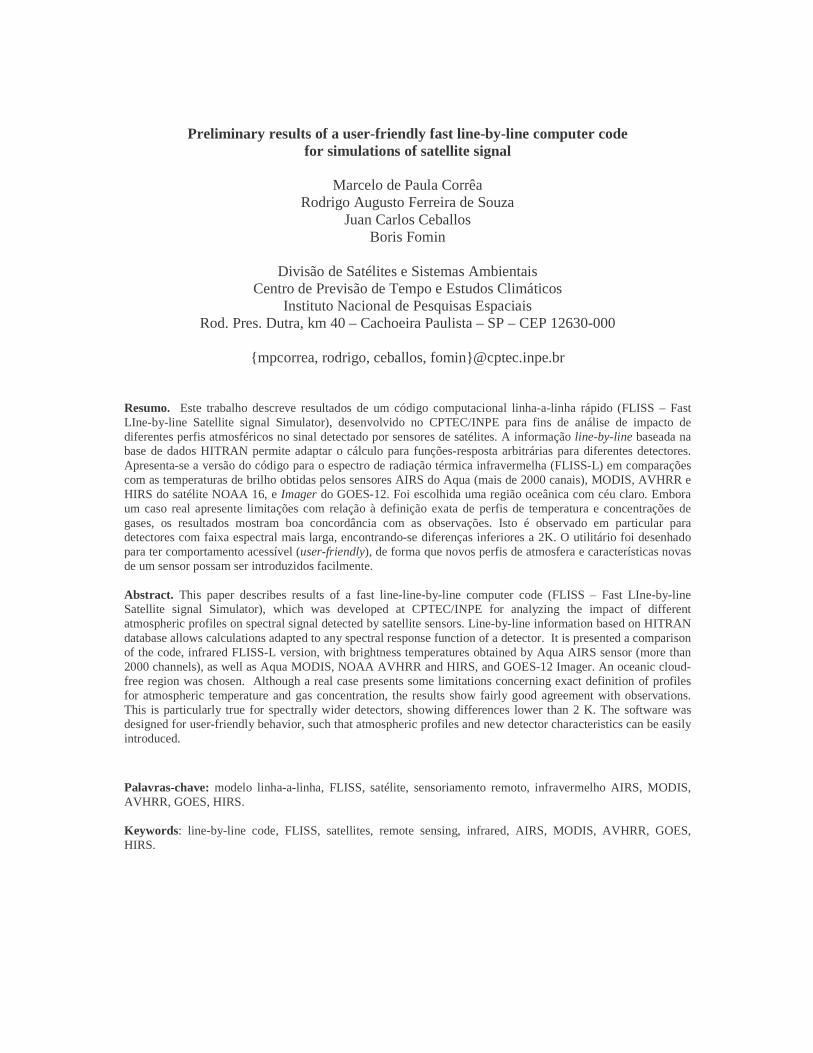
Preliminary results of a user-friendly fast line-by-line computer code for simulations of satellite signal
Marcelo de Paula Corrêa
Rodrigo Augusto Ferreira de Souza Juan Carlos Ceballos
Boris Fomin
Divisão de Satélites e Sistemas Ambientais Centro de Previsão de Tempo e Estudos Climáticos
Instituto Nacional de Pesquisas Espaciais Rod. Pres. Dutra, km 40 – Cachoeira Paulista – SP – CEP 12630-000
{ mpcorrea, rodrigo, ceballos, fomin}@cptec.inpe.br
Resumo. Este trabalho descreve resultados de um código computacional linha-a-linha rápido (FLISS – Fast LIne-by-line Satellite signal Simulator), desenvolvido no CPTEC/INPE para fins de análise de impacto de diferentes perfis atmosféricos no sinal detectado por sensores de satélites. A informação line-by-line baseada na base de dados HITRAN permite adaptar o cálculo para funções-resposta arbitrárias para diferentes detectores. Apresenta-se a versão do código para o espectro de radiação térmica infravermelha (FLISS-L) em comparações com as temperaturas de brilho obtidas pelos sensores AIRS do Aqua (mais de 2000 canais), MODIS, AVHRR e HIRS do satélite NOAA 16, e Imager do GOES-12. Foi escolhida uma região oceânica com céu claro. Embora um caso real apresente limitações com relação à definição exata de perfis de temperatura e concentrações de gases, os resultados mostram boa concordância com as observações. Isto é observado em particular para detectores com faixa espectral mais larga, encontrando-se diferenças inferiores a 2K. O utilitário foi desenhado para ter comportamento acessível (user-friendly), de forma que novos perfis de atmosfera e características novas de um sensor possam ser introduzidos facilmente. Abstract. This paper describes results of a fast line-line-by-line computer code (FLISS – Fast LIne-by-line Satellite signal Simulator), which was developed at CPTEC/INPE for analyzing the impact of different atmospheric profiles on spectral signal detected by satellite sensors. Line-by-line information based on HITRAN database allows calculations adapted to any spectral response function of a detector. It is presented a comparison of the code, infrared FLISS-L version, with brightness temperatures obtained by Aqua AIRS sensor (more than 2000 channels), as well as Aqua MODIS, NOAA AVHRR and HIRS, and GOES-12 Imager. An oceanic cloud-free region was chosen. Although a real case presents some limitations concerning exact definition of profiles for atmospheric temperature and gas concentration, the results show fairly good agreement with observations. This is particularly true for spectrally wider detectors, showing differences lower than 2 K. The software was designed for user-friendly behavior, such that atmospheric profiles and new detector characteristics can be easily introduced. Palavras-chave: modelo linha-a-linha, FLISS, satélite, sensoriamento remoto, infravermelho AIRS, MODIS, AVHRR, GOES, HIRS. Keywords: line-by-line code, FLISS, satellites, remote sensing, infrared, AIRS, MODIS, AVHRR, GOES, HIRS.

1. Introduction
There exist a number of softwares for radiative transfer calculations, including those that perform satellite signal simulation. Examples of well-known codes are: LOWTRAN (Kneysis et al., 1988), SBDART (Ricchiazzi et al., 1998), 5S (Tanré et al., 1986) and its new 6S version (Vermote et al., 1997). Historically, one of the main concerns refers to an efficient match between required accuracy and available processing time. In the lack of such matching, precise radiative codes tend to be used only for benchmark calculations, sensibility tests and hypotheses validations. Fast calculations are mainly performed on the base of narrowband parameterizations. Nevertheless, recent personal computers have attained a performance thinking of powerful mainframes a decade ago.
This fact suggests the convenience of developing fast radiative transfer codes based on line-by-line information, which could provide the highest accuracy presently available with reasonably low computation cost. The proposed challenge implies in developing proper methods for working with HITRAN database, whose version 2004 includes 1,734,469 spectral lines for 37 different molecular species (http://www.hitran.com). Such radiative code should allow inclusion of proper information about atmospheric structure and satellite sensor spectral response, providing tools to discuss accuracy of sensor quality and design of new sensors, as well as to improve understanding of the influence of atmospheric gases (natural and anthropogenic) and parameterize their effects.
A new radiative code was developed at the Divisão de Satélites e Sistemas Ambientais (DSA/CPTEC/INPE), which seeks to answer to the abovementioned requirements. It is labeled as FLISS (Fast Line-by-line Satellite signal Simulator). The present work shows preliminary results of using FLISS-L version for simulated brightness temperature in the longwave (infrared) interval, expected for several satellite sensors. It has been considered a real case of atmospheric profile over Atlantic Ocean. Comparison with measurements performed by the actual sensors is presented and discussed.
2. Algorithm Description
The latest version of spectral database HITRAN-11 v (Rothman et al., 2003) and continuum model by N2, O2, O3, CO2 and H2O (CKD-2.4) have been used in FLISS, based on the same physical assumptions used in the carefully validated Line-by-Line Radiation Transfer Model (LBLRTM) (Clough et al., 1992; Clough and Iacono, 1995). However, FLISS makes use of other line-by-line algorithms for gas absorption calculations (Fomin, 1994) and vertical integration (Fomin et al., 2004). The use of this line-by-line method not only increases the accuracy but also performs different applications in any spectral width interval, avoiding previous development of gas absorption parameterizations. The FLISS main feature is the clear physical meaning of calculation procedures. For instance, spectral resolution in FLISS is varied automatically so that the narrowest spectral line can be adequately sampled.
The new feature introduced by FLISS is the user-friendly interface for input of several information and a computational speed being higher than those of usual LBL codes found in the literature. Present FLISS version provides several default data bases for the user: a) model atmospheric profiles (McClatchey et al., 1972); b) spectral ground reflectances; c) response function for several sensors (MODIS, AIRS, AVHRR, HIRS and GOES Imager). Also, the user can introduce your own version of these data. FLISS is a multi-platform computer program developed in Fortran90, compatible with MS-Windows, Linux and UNIX. Presently, it has two versions for specific spectral regions: FLISS-S for solar radiation, including applications for clouds and aerosols, and FLISS-L for infrared and microwave spectrum. Version L does not include absorption/scattering by atmospheric particulate (aerosol or cloud).

3. Methods and Data
Brightness temperature data collected by DSA/CPTEC/INPE were considered (sensors AVHRR and HIRS in NOAA-16; AIRS and MODIS in Aqua; GOES-12 Imager), selected through clear-sky pixels in images over Atlantic Ocean. Based on these needs, we chose 30th August 2004 for the comparisons. Figure 1 illustrates geographical position of the selected point (26°S, 43°W), for which pixels of the various sensors were chosen. For FLISS-L calculations, retrieved and theoretical profiles were introduced. It was used NASA retrievals (provided by Aqua satellite) of air and surface temperatures and moisture and O3 profiles. For other gases (CO2, CH4, N2O, O2) a midlatitude summer model profile (McClatchey et al., 1972) was adopted.
Figure 1 – Quick look of the region of study (visible AIRS channels)
AIRS sensor has 2378 channels in infrared spectrum, while the other sensors include a number of
channels not exceeding a couple of dozens. Table 1 illustrates spectral positions of last ones. Figure 2 (observed and simulated results) allows seeing the spectral distribution of these sensors.
Sensor Channel number (spectral interval in µm)
MODIS
20 (3.66 – 3.84); 21 (3.93 – 3.99); 22 (3.93 – 3.99); 23 (4.02 – 4.08); 24 (4.43 – 4.50); 25 (4.48 – 4.55); 27 (6.54 – 6.90); 28 (7.18 – 7.48);
29 (8.40 – 8.70); 30 (9.58 – 9.88); 31 (10.78 – 11.28); 32 (11.77 – 12.27); 33 (13.19 – 13.49); 34 (13.49 – 13.79); 35 (13.79 – 14.09); 36 (14.09 – 14.39)
GOES-12 Imager 2 (3.78 – 4.03); 3 (6.47 – 7.02); 4 (10.2 – 11.2); 5 (11.5 –12.5)
HIRS
1 (14.88 – 15.02); 2 (14.49 – 14.93); 3 (14.25 – 14.75); 4 (13.91 – 14.56); 5 (13.66 – 14.29); 6 (13.35 – 13.95); 7 (13.07 – 13.64); 8 (10.70 – 11.56);
9 (9.48 – 9.95); 10 (12.22 – 12.72); 11 (7.12 – 7.55); 12 (6.20 – 6.88); 13 (4.52 – 4.62); 14 (4.48 – 4.57); 15 (4.43 – 4.52); 16 (4.41 – 4.50);
17 (4.09 – 4.17); 18 (3.93 – 4.02); 19 (3.62 – 3.91) AVHRR 3 (3.55 – 3.93); 4 (10.3 – 11.3); 5 (11.5 – 12.5)
Table 1 – Spectral intervals of the satellite sensors

Figure 2 – Brightness temperature for different sensors: observations and calculations.
4. Results
Figure 2 allows a general comparison of observed and simulated brightness temperatures and
figures 3 (a,b,c,d) provide more detailed observations for discussion of results. Figure 3a presents the spectral interval between 3.6 and 4.8 µm, characterized by an atmospheric
window and neighboring absorption/emission bands for water vapor (H2O), carbon dioxide (CO2) and nitrous oxide (N2O). Differences lower than 2 K are evident within the atmospheric window. It is worthwhile to note that AVHRR, MODIS and GOES channels in this spectral region are used for fire detection. Differences become high for λ > 4 µm, especially where influence of N2O is expected (this gas has variable concentration in the atmosphere).
Figure 3b (6.0 to 8.0 µm) exhibits strong absorption/emission by H2O by a CH4 band. The comparison makes evident limitations for narrowband channels simulation in this complex region, while wider spectral channels of other sensor show fairly good agreement.
Figure 3c illustrates results for the mid-infrared atmospheric window and the 9.6 µm ozone band. Agreement between simulated and observed temperatures is good throughout the window (differences lower than 1.5 K), except for GOES channel 4. One simple reason for these small differences may be attributed to electronic noise. For 9.6 µm region, systematic differences of about 5 K are observed. This behavior could be due to a somewhat poor ozone and/or temperature profile by the NASA Aqua retrieval procedure within the stratosphere, where ozone absorption/emission is more intense.
Figure 3d shows the 14 µm CO2 absorption band region, usually used for temperature retrieval of the atmosphere. Here, difference between simulation and observation is systematically positive for wideband detectors, between +2 K and +6.6 K; nevertheless, they are still better than results for the narrower AIRS channels. For this sensor, discrepancies are not random and show oscillations between +5 K and –15 K along this spectral region. Several reasons can be drawn for this behavior; among others, it may be due to influence of water vapor continuum, adopted CO2 profile (constant concentration of 370 ppm), or even deviations between retrieved and actual temperature profile.

Figure 3a – Atmospheric window (3.6 µm), water vapor, nitrous oxide and carbon dioxide bands.
Figure 3b – Water vapor, carbon dioxide, nitrous oxide and methane bands.

Figure 3c – Atmospheric window with ozone absorption band (9.6 µm).
Figure 3d – Water vapor and carbon dioxide bands.
5. Conclusions and Perspectives
Only one test of FLISS-L performance has been presented. However, it strongly suggests a
generally good agreement between simulation and real data for five different satellite sensors in infrared thermal spectrum. In the case of AIRS sensor, with more than 2000 spectrally narrow channels, the general average of differences was +1.8 K with standard deviation 4.2 K. These values are lower for the atmospheric window (+1.5 ± 1.1 K), they amount +2.9 ± 2.7 K in the ozone band region and +5.3 ± 1.9 K in the 6.4 µm in the strong water vapor band. Improvements in results could be obtained by: a) better definition of temperature and gaseous concentration profiles (radiosonde profiles would be recommended); b) updated definition of response functions (in particular, those of AIRS sensor); c) careful choice of cloud-free pixels; d) precise estimation of ground reflectance and temperature (ocean surface was considered in this paper, certainly suitable for this type of comparison; tests over land surface should be exhibit larger differences). It must be stressed that spectrally narrow channel signal is a delicate matter of estimation; in this context, spectral behavior of some atmospheric gases (in particular water vapor) is not necessarily well defined and is still a matter of research by the world main groups of spectroscopy (see http://www.hitran.com). Last but not least, atmospheric composition considered in this paper does not include all available gas data. HITRAN includes 37 species. In the case of spectrally wider sensors, similar recommendations are appropriate; nevertheless, it seems evident that a wider spectral interval tends to lower (or compensate) the effects of unknowing the spectrally most fine structure of atmospheric radiation.
The results suggest that the software may attain fairly good estimates with spectral high definition, being appropriate for simulation of behavior of the new generation of environmental satellites. It is worthwhile to note that FLISS-L does not depend on previous parameterizations of radiative transmittance but strictly on line-by-line calculations. Present version has a user-friendly interface, which permits its use for other sensors and cloud-free atmospheric profiles. FLISS-L can be used not only for simulation of sensor signals, but also for parameterizing gas content and its fluctuations as a function of observed signal. The tests presented in this paper were run in a personal computer Pentium 4, with 2.80 GHz clock , 512 MB RAM and MS-Windows operational system.
Acknowledgments
This work has partially supported by the CNPq foundation (grant 301263019), Brazil.
References
Clough, S. A.; Iacono M. J.; Moncet J.-L. Line-by-line calculation of atmospheric fluxes and cooling rates: Application to water vapor. Journal of Geophysical Research, v. 97, p. 15761-15785, 1992.
Clough, S.A.; Iacono, M.J. Line-by-line calculations of atmospheric fluxes and cooling rates II: Application to carbon dioxide, ozone, methane, nitrous oxide, and the halocarbons. Journal of Geophysical Research, v. 100 , n. 16, p. 519-16,535, 1995.
Fomin, B.A. Benchmark computation for solar fluxes and influxes in aerosol and cloudy atmosphere. Izvetyia Atmospheric Oceanic Physics, v. 30, n. 3, p. 283-290, 1994.
Fomin, B.A. A Distribution Technique for Radiative Transfer Simulation in Inhomogeneous Atmosphere: 1. FKDM, Fast K-Distribution Model for the Longwave, Journal of Geophysical Research-Atmospheres, v. 109, n. D2, D02110, paper n. 10.1029/2003JD003802, 2004.
Kneizys, F.X.; Shettle, E.P.; Abreu, L.W.; Chetwynd, J.H.; Anderson, G.P.; Gallery, W.O.; Selby; J.E.A.; Clough, S.A.. Users guide to LOWTRAN-7. Environmental Research Papers, n. 1010, Publ. AFGL-TR-88-0177, Air Force Geophys. Lab., Hanscom, 146 p., 1988.
Mc Clatchey, R.A.; Fenn, R.W.; Selby, J.E.A.; Volz, F.E.; Garing, J.S. Optical properties of the atmosphere. Publ. AFCRL-72-0497, Air Force Cambridge Res. Lab., Hanscom, 1972.
Ricchazzi, P.; Yang, S. R. SBDART: A research and teaching software tool for Plane-parallel radiative transfer in the earth's atmosphere. Bulletin of the American Meteorological Society, v. 79, n. 10, p. 2101-2114, 1998.

Tanre, D.; Deroo, C., Duhaut, P., Herman, M., Morcrette, J. J.; Perbos, J.; Deschamps, P.Y. Simulation of the satellite signal in the solar spectrum (5S). Technical Report of Laboratorire d'Optique Atmospherique Université des Sciences et Techniques de Lille, 149pp, 1986.
Rothman, L.S. et al. The HITRAN molecular spectroscopic database: edition of 2000 including updates through 2001. Journal of Quantitative Spectroscopy and Radiative Transfer, v. 82, p. 5-44, 2003.
Vermote, E. F.; Tanré, D.; Deuzé, J. L.; Herman, M.; Morcette, J. J. Second Simulation of the Satellite Signal in the Solar Spectrum, 6S: An Overview. IEEE Transactions on Geoscience and Remote Sensing, v. 35, p. 675-686, 1997.