Embed Size (px)
Citation preview
INSTITUTO NACIONAL DE PESQUISAS DA AMAZÔNIA - INPA
PROGRAMA DE PÓS-GRADUAÇÃO EM ECOLOGIA
A TRANSFORMAÇÃO HUMANA PRÉ-COLOMBIANA DA PAISAGEM
FLORESTAL NO INTERFLÚVIO PURUS-MADEIRA, AMAZÔNIA
CENTRAL
CAROLINA LEVIS
Manaus, AM
Julho, 2012

i
CAROLINA LEVIS
A TRANSFORMAÇÃO HUMANA PRÉ-COLOMBIANA DA PAISAGEM
FLORESTAL NO INTERFLÚVIO PURUS-MADEIRA, AMAZÔNIA
CENTRAL
Orientadora: Dra. Flávia Regina Capellotto Costa
Dissertação apresentada ao Instituto Nacional de
Pesquisas da Amazônia como parte dos requisitos para
obtenção do título de Mestre em Biologia (Ecologia).
Manaus, AM
Julho, 2012

ii
Relação da banca julgadora
1. Banca examinadora do trabalho de conclusão – versão escrita
Mark Bush (Florida Institute of Technology) - Aprovada com correções
Marielos Peña Claros (Wageningen University) - Aprovada com correções
David G. Campbell (Grinnell College) - Aprovada
2. Banca examinadora do trabalho de conclusão – defesa presencial
Evandro José Linhares Ferreira (Instituto Nacional de Pesquisas da Amazônia - Acre) -
Aprovada
Henrique dos Santos Pereira (Universidade Federal do Amazonas) - Aprovada
Valdely Ferreira Kinupp (Instituto Federal de Educação, Ciência e Tecnologia do Amazonas)
- Aprovada
iii
Ficha Catalográfica
Sinopse:
Estudou-se o impacto da manipulação humana passada sobre a
paisagem florestal em um gradiente que parte da margem dos rios
Solimões, Purus e Madeira e adentra o interflúvio. A abundância,
riqueza e área basal das espécies árboreas úteis, indicadoras de
alteração humana passada, a massa de carvão no solo e a
quantidade de evidências arqueológicas foram avaliadas.
Palavras-chave: Ecologia histórica, ameríndios, manejo da
paisagem, plantas úteis, carvão
L666 Levis, Carolina
A transformação humana pré-colombiana da paisagem florestal no
interflúvio Purus-Madeira, Amazônia Central / Carolina Levis. ---
Manaus : [s.n.], 2012.
viii, f. 41: il. color.
Dissertação (mestrado) --- INPA, Manaus, 2012
Orientador : Flávia Regina Capellotto Costa
Área de concentração : Ecologia
1. Floresta madura – Amazônia. 2. Plantas úteis. 3. Ameríndios.
4. Influência sobre a paisagem. 5. Floresta antrópica. 6. Carvão . I. Título.
CDD 19. ed. 574.5263

iv
Agradecimentos
À CAPES pela bolsa concedida;
À FAPEAM (Fundação de Amparo à Pesquisa do Estado do Amazonas) pelo financiamento
do projeto;
Ao PPBio (Programa de Pesquisa em Biodiversidade) pelo apoio logístico;
À minha família, pelo amor incondicional;
Aos professores da pós-graduação em Ecologia pela dedicação em ministrar aulas tão boas
que me formaram como ecóloga;
À Flávia Costa, que aceitou me orientar e mesmo com 1001 funções, atividades e alunos foi
uma excelente orientadora. Fez com que análises complexas e idéias abstratas fossem fáceis
de serem compreendidas, ditas e escritas;
Ao Charles Clement, grande motivador e idealizador do trabalho e o melhor (des)orientador
que poderia ter tido. Orientação impecável com muito bom humor, idéias incríveis e muito
inspiradoras;
Ao Bernardo Flores (Bê), meu orientador particular de todas as horas. Por despertar a paixão
de fazer ciência e pela dedicação em discutir o projeto, repensar os problemas, encontrar
soluções e desencanar das inseguranças. E o mais importante, por compartilhar a vida com
muito amor, alegria e novidades, tornado meus dias e noites muito mais prazerosos;
Aos avaliadores do plano da dissertação e e aos membros da banca da aula de qualificação:
Bruce Nelson, William Balée, David Campbell, Rita Mesquita, Valdely Kinupp, Charles
Clement;
Ao André Junqueira pela idealização do projeto e as conversas construtivas e esclarecedoras;
Ao Nigel Smith por todo bibliografia e material cedido e pelas conversas inspiradoras;
À Thaise Emílio, Gabriel Moulatlet e Juliana Schietti pela ajuda nas análises estatísticas e
pelos dados de hidrologia e estrutura da vegetação;
Ao José Luís Pinto (Zeca) pela coleta de solos para análise de carvão;
À Priscila Souza, companheira fiel dos trabalhos de campo, por dividir todas as dificuldades e
alegrias do trabalho na floresta, na BR e pela incrível persistência e dedicação na identificação
de milhares de plantas estéreis. Também pela amizade e companheirismo;
À Família Vegetal pela união, força e descontração para enfrentar dias de trabalhos muito
intensos;
v
Ao Alexandro Santos (Alex) pelo auxílio fundamental na identificação das plantas e pelos
ensinamentos de botânica;
À Francislaide pela ajuda na triagem do carvão;
Aos auxiliares de campo, Alexandro (Alex), José Adaílton (Zé), Thiago (Taco), Elson e
Israel, pelo trabalho árduo na floresta e na coleta de plantas e solos;
Aos moradores da BR-319, Dona Irene, Dona Maria, entre outros, pela hospitalidade e
saberes;
Aos companheiros de campo, Bruno, Rodrigo, Juruna por tornarem a temporada na floresta
divertida;
À família manauara, Luana, Paulo e Amélia, por me acolher quando cheguei a Manaus;
À família carioca em Manaus, Pimentinha, Jerê, Danete, Suiço, Estopa, por dividir um lar e
compartilhar minhas crises, realizações e alegrias durante esses dois anos;
Aos amigos, Carolzinha, Gui, Mari, Flavinha, Fê, Bruno, Rodrigo, Marina, Cabeça, Pri,
Brunão, e os outros que não mencionei, por tornar a vida muito mais agradável e feliz;
Aos moradores da Casa Preta, Natalia, Brunão, JB, Arnold, Zeca, McCrate, Rodrigo, por me
acolherem, por proporcianerem dias felizes, com muita música e festa;
Ao Yoga, especialmente à Mari, por tornar a minha vida mais leve, flexível, feliz e cheia de
força para entrentar os desafios com calma e sabedoria;
À Amazônia e as pessoas que viveram e vivem da floresta, o sentido deste estudo.
vi
Resumo
A partir de aproximadamente 3000 anos atrás, populações nativas da Amazônia passaram a
desenvolver sistemas eficientes de manejo dos recursos florestais, frequentemente criando
florestas oligárquicas dominadas por árvores úteis. No entanto, a distribuição espacial e a
escala de modificação da floresta permanecem desconhecidas. Estudos recentes propõem que
o impacto humano longe dos maiores rios era mínimo, o que sugere que os interflúvios eram
relativamente intocados. Este estudo avaliou as variações no grau de manipulação humana
passada sobre a vegetação em seis locais ao longo do interflúvio Purus-Madeira, com
diferentes distâncias até os rios principais e secundários. Em todos os locais as árvores úteis
com DAP ≥ 10 cm foram inventariadas em duas parcelas de 1 ha e em cinco parcelas o solo
para triagem de carvão foi coletado em três trincheiras até 50 cm de profundidade. Também
foram mapeadas evidências arqueológicas nas proximidades dos locais estudados. Foi
calculada a menor distância em quilômetros de cada parcela para os rios. Para quantificar a
manipulação da floresta foram medidas a riqueza, abundância e área basal relativas de árvores
úteis, especialmente frutíferas e palmeiras, e a massa de carvão no solo. Foram testadas as
relações entre estes parâmetros e a distância aos rios. Encontramos relações exponenciais
negativas fortes entre a manipulação da floresta e a distância dos rios principais. Parcelas
localizadas entre 10 a 20 km de um rio principal tiveram 20-40% de espécies arbóreas úteis,
parcelas com distâncias entre 20-40 km tiveram 15-25% de árvores úteis, enquanto parcelas a
mais de 40 km tiveram menos de 15%. A abundância do carvão foi alta em duas áreas, as
mais próximas de rios secundários. A menor distância entre as parcelas e as evidências
arqueológicas foi encontrada nos locais mais próximos de rios. Estes resultados sugerem
fortemente que a manipulação passada da floresta não se limita aos assentamentos pré-
colombianos nas margens dos rios principais, mas se estendeu sobre florestas do interflúvio
consideradas primárias atualmente. O uso sustentável e a conservação dos recursos florestais
da Amazônia serão mais eficazes se considerar o grau de domesticação da paisagem, já que
essas florestas concentram plantas úteis resultantes do enriquecimento humano passado.
vii
Pre-Colombian human transformation of forest landscapes of the Purus-
Madeira interfluve, Central Amazonia
Abstract
Starting at least 3000 years before present, Native Amazonian populations expanded to
several millions and developed efficient systems for managing forest resources, often creating
oligarchic forests dominated by useful trees. The densest human populations were located
along the major whitewater rivers. However, the scale and spatial distribution of forest
modification is still unknown. Recent studies propose that human impact away from the rivers
was minimal, which suggests that interfluves were relatively undisturbed in the past. Our
study assessed the variations in the degree of past human manipulation of floristic
composition in forests at six sites along the Purus-Madeira interfluve as a function of the
distance from the main and secondary rivers. In all sites we inventoried useful trees with DBH
≥ 10 cm in two 1 ha plots and in five plots soil for charcoal analysis was collected in three soil
pits. We also mapped archaeological evidence around the study sites. The shortest distance in
kilometers from each plot to the rivers was calculated. To quantify forest manipulation, we
measured the relative richness, abundance and basal area of useful trees, especially fruit trees
and palms. We tested the relationships between these parameters and the plot’s distance to the
rivers and the difference of soil charcoal mass between the six sites. We found strong negative
exponential relationships between forest manipulation and the distance to main and secondary
rivers. Plots located from 10 km to 20 km from a main river had 20-40% useful tree species,
plots with distances between 20-40 km had 15-25% useful trees, while plots greater than 40
km had less than 15%. Soil charcoal abundance was high in two sites with the shortest
distances to secondary rivers. The shortest distance between plots and archaeological
evidences was found in sites near rivers. These results strongly suggest that past forest
manipulation by humans was not limited to the pre-Columbian settlements at the edges of the
main rivers, but extended over interfluvial areas considered to be primary forest today. The
sustainable use and conservation of Amazonian forest resources will be most effective if it
considers the degree of past landscape domestication, as these landscapes concentrate useful
plants related to human management.
viii
Sumário
1. Introdução.............................................................................................................................1
2. Objetivos................................................................................................................................4
3. Capítulo único: Pre-Colombian human transformation of forest landscapes of the Purus-
Madeira interfluve, Central Amazonia.......................................................................................5
4. Conclusão Geral..................................................................................................................36
5. Apêndices.............................................................................................................................37

1
INTRODUÇÃO
A crença de que os ambientes naturais das Américas foram relativamente intocados
por seres humanos antes da conquista europeia não é mais sustentada (Wills et al. 2004,
Denevan 2011). A partir de aproximadamente 3000 anos atrás, as populações humanas pré-
colombianas aumentaram de tamanho, densidade e duração das suas ocupações (Piperno e
Pearsall 1998). As paisagens e muitas plantas foram domesticadas em diferentes graus para
atender as necessidades dessas sociedades (Clement 1999). Mas, a extensão e o impacto da
domesticação na paisagem amazônica são controversos. Enquanto alguns arqueólogos
sugerem uma modificação completa da paisagem (Erickson 2008, Heckenberger 2003),
ecólogos argumentam o oposto, que a maior extensão da bacia não apresenta sinais de
perturbação (Peres et al. 2010, Barlow et al. 2012). Bush e Silman (2007) e McMichael et al.
(2012) propõem uma hipótese intermediária, na qual a intensidade da perturbação da floresta
decresce exponencialmente com o aumento da distância dos grandes rios da Amazônia e
especialmente em florestas não sazonais.
As manchas de solos antrópicos, chamadas de terra preta de índio (TPI), geralmente
estão nas margens dos grandes rios (WinklerPrins e Aldrich 2010). As terras pretas são solos
culturais e diferem-se dos solos naturais pelos altos níveis de fósforo (P) e cálcio (Ca), pela
presença de artefatos cerâmicos, bem como pela coloração escura causada por altas
concentrações de carvão (Woods e McCaan 1999). Esses solos altamente férteis foram
criados pelos povos amazônicos desde 5000 a 500 anos atrás (Neves et al. 2003),
provavelmente pela acumulação de lixo nos assentamentos permanentes e por um longo
processo de manejo do solo (Woods e McCaan 1999). Os processos específicos envolvidos na
criação desses solos permanecem desconhecidos, mas certamente a vida sedentária e a
agricultura extensiva foram essenciais para a sua criação (Neves et al. 2003). Essas evidências
fizeram com que os antropólogos e arqueólogos assumissem que os povos indígenas
preferencialmente residiram em áreas mais elevadas nas margens dos rios de água branca, nos
barrancos (Denevan 1996). A preferência pelos barrancos desses rios é explicada pela maior
concentração de recursos alimentares e solos mais férteis nas várzeas (Denevan 1996).
Estudos recentes sugerem que o impacto humano fora dos locais de alta densidade
populacional tenha sido muito limitado (Bush e Silman 2007) e o raio de influência humana
na paisagem ao redor do centro de habitação tenha sido restrito (McMichael et al. 2012).

2
Entretanto, centenas de geoglifos foram encontrados no interflúvio do alto Purus-
Madeira, distribuídos numa área de 250 km de extensão do norte ao sul, englobando tanto
áreas de várzeas como de terra-firme (Pärssinen et al. 2009). A existência dessas estruturas
sugere a presença de sociedades complexas e populações densas em áreas interfluviais,
ambientes anteriormente descritos como incapazes de suportar um número elevado de pessoas
(Pärssinen et al. 2009). No entanto, a distribuição, extensão e o impacto dos povos pré-
colombianos na floresta distante dos grandes rios ainda permanecem desconhecidos. Estudos
ecológicos e arqueológicos são escassos nos interflúvios, que constituem a maior proporção
da paisagem amazônica (Pitman et al. 2011, Barlow et al. 2012).
A presença de sociedades humanas bem estruturadas com técnicas avançadas de
manejo da paisagem deixou marcas visíveis também na vegetação (Balée 2006, Erickson
2008). Os povos amazônicos identificaram espécies na comunidade florestal de grande
utilidade e passaram a construir florestas oligárquicas na Amazônia, ampliando a abundância
de certas espécies (Balée 1989, Clement et al. 2003). As florestas antropogênicas são florestas
dominadas por uma ou mais espécies úteis. Em muitos casos, somente percebemos sinais da
manipulação humana na floresta através da distribuição e abundância dessas espécies, e
devido à sua alta diversidade são comumente consideradas florestas primárias (Peters 2000).
As manchas de castanheiras (Bertholletia excelsa Bonpl.), conhecidas como castanhais, e as
florestas dominadas por certas palmeiras, como o caiaué (Elaeis oleifera (Kunth) Cortés),
conhecidas como caiauezais, são exemplos de florestas oligárquicas antropogênicas (Balée
1989, Shepard e Ramirez 2010). Castanheiras com diâmetro maiores que 220 cm são
provavelmente mais antigas que a colonização da Amazônia, contando a partir da fundação de
Bélem, Pará, em 1616 (Chambers et al. 1998). O caiaué é pouco usado atualmente pelas
populações tradicionais (Cunha et al. 2009); então, sua relação com o homem também está
ligada ao período pré-colonial.
Nós examinamos a influência humana passada sobre a floresta, a partir dos rios
Solimões, Purus e Madeira, adentrando o interflúvio e considerando o papel dos rios
secundários que penetram na região. As condições ambientais desses grandes rios são
favoráveis à presença humana; todos abrigam águas ricas em nutrientes dissolvidos e solos
férteis nas suas planícies de inundação (Furch e Junk 1997). Os índios da etnia Mura são
citados como os principais habitantes do norte da região durante o período pré-colonial
(Cunha 1992). No final do século XIX, o rio Madeira foi reocupado para a produção de

3
borracha, proveniente da extração de látex da seringueira (Hevea brasiliensis (Willd. ex
A.Juss.) Müll. Arg.). Os grandes rios possuem muitas manchas de terra preta em suas
margens, especialmente o Solimões e o Madeira (WinklerPrins e Aldrich 2010); já os rios
secundários possuem águas pretas e não têm registros arqueológicos até o presente estudo.
Em algumas localidades do interflúvio, as florestas são submetidas a solos encharcados na
época chuvosa, criando um ambiente inapropriado para ocupação humana sedentária e para a
agricultura intensiva durante todo o ano. Mesmo nessas condições, buscamos mostrar que as
florestas do interflúvio apresentam sinais de manipulação de acordo com a distância dos rios
da região.
Examinamos a intervenção humana na vegetação pela abundância, riqueza e área basal
das espécies úteis, principalmente frutas comestíveis e palmeiras. Usamos também a massa de
carvão no solo para confirmar a presença de atividades humanas passadas nos locais. O fogo é
a ferramenta mais poderosa na transformação da paisagem (Erickson 2008) e uma das
principais evidências de distúrbios humanos em florestas tropicais (Stanford e Horn 2000,
Bush e Silman 2007). Devido à inexistência de dados arqueológicos no interior do interflúvio,
mapeamos as evidências arqueológicas, castanhais e caiauezais nas áreas estudadas. Usamos
todas essas informações para testar a hipótese de que a intervenção humana passada sobre a
comunidade arbórea diminui com o aumento da distância dos rios da região.

4
OBJETIVOS
Determinar a extensão e o efeito das transformações humanas do passado sobre a paisagem
florestal e a composição florística útil em seis áreas do interflúvio Purus-Madeira.
Para avaliar a influência humana na paisagem florestal do interflúvio, pretendemos responder
as seguintes questões:
1 – A existência das paisagens domesticadas no interflúvio Purus-Madeira é maior em áreas
mais próximas de rios principais e secundários?
2 – O efeito humano sobre a comunidade de árvores úteis diminui com o aumento da distância
dos rios da região?
3 – A abundância de carvão no solo da floresta é maior nas áreas mais próximas dos rios?
5
Capítulo 1
__________________________________________________ Levis C, Souza PF, Schietti J, Souza TEL, Pinto JLVP, Clement CR, Costa FRC Pre-
Colombian human transformation of forest landscapes of the Purus-Madeira interfluve,
Central Amazonia. Manuscrito formatado para Proceedings of the National Academy of
Sciences USA - PNAS

6
BIOLOGICAL SCIENCES: Sustainability Science
Pre-Colombian human transformation of forest landscapes of the Purus-
Madeira interfluve, Central Amazonia
Carolina Levisa, Priscila F. Souza
b, Juliana Schietti
a, Thaise Emilio
a, Jose L. V. P. Pinto
c,
Charles R. Clementd, and Flávia R. C. Costa
c
a Graduate Program in Ecology, National Institute for Amazonian Research (INPA), Av.
André Araújo, 2936 – Aleixo, 69060-001 Manaus, Amazonas, Brazil; b
Graduate Program in
Botany, INPA; cBiodiversity Department, INPA;
d Technology and Innovation Department,
INPA.
Corresponding author: Carolina Levis
Address: Av. André Araújo, 2936, Aleixo, 69083-260 Manaus, Amazonas, Brazil
Telephone number: 55 (92) 82477490
E-mail: [email protected].
7
Abstract
Native Amazonian populations managed forest resources in numerous ways, often creating
oligarchic forests dominated by useful trees. The scale and spatial distribution of forest
modification is still unknown, although recent studies propose that human impact away from
rivers was minimal. We tested the hypothesis that past human management of the useful tree
community decreases with distance from rivers. In six sites, we inventoried trees with DBH ≥
10 cm and collected soil for charcoal analysis. We also mapped archaeological evidence
around the study sites. The shortest distance in kilometers from each plot to rivers wider than
50 m was measured. To quantify forest manipulation, we measured the relative abundance,
richness and basal area of useful trees. We found a strong negative exponential relationship
between forest manipulation and the distance to large rivers. Plots located form 10 km to 20
km from a main river had 20-40% useful tree species, plots between 20 and 40 km had 15-
25%, plots more than 40 km had less than 15%. Soil charcoal abundance was high in the two
sites closest to secondary rivers. The shortest distance between archaeological evidence and
plots was found in sites near rivers. These results strongly suggest that past forest
manipulation by humans was not limited to the pre-Columbian settlements, but extended over
interfluvial areas considered to be primary forest today. The sustainable use of the Amazonian
forests will be most effective if it considers the degree of past landscape domestication, as
human-modified landscapes concentrate useful plants for human use and management today.
Keywords Historical ecology / landscape modification / interfluve / useful tree community / charcoal
Text
The common belief that natural environments of the Americas were relatively
untouched by humans before the European conquest is no longer accepted (1, 2). Starting at
least 3000 years before present, pre-Columbian populations increased in size, density and
duration of their occupations (3). Landscapes and many plants were domesticated in different
degrees to sustain these societies (4). The extent and impact of Amazon landscape
domestication, however, are still controversial. While some archaeologists suggest extensive
modification of the landscape (5, 6), ecologists often argue the opposite, that most of the
Amazon basin shows little sign of disturbance (7, 8). Bush & Silman (9) and McMichael et al.
(10) suggest an intermediate hypothesis, in which the intensity of human impacts decreases
exponentially with increasing distance from the major Amazonian rivers, especially in non-
seasonal forests. Human impacts that are easily recognized include changes in soils and relief,
such as anthropogenic soils and geoglyphs, as well as changes in forest composition,
especially forests dominated by a few useful species, known as oligarchic forests (11).
8
Anthropogenic soils, called Terra Preta de Índio or Amazonian Dark Earths (ADE),
are usually found on bluffs along the major rivers (12, 13). Amazonian Dark Earths are
cultural deposits and are very different from background soils, having a dark color due to high
concentrations of charcoal, high levels of some nutrients, especially calcium (Ca) and
phosphorus (P), and the presence of archaeological artifacts (14). These soils were created by
Native Amazonians from about 5000-500 years before present (15), by the accumulation of
waste around permanent settlements and long-term soil management practices (14). The
specific processes that explain their origin remain poorly understood, although a sedentary
lifestyle and intensive agriculture were probably crucial for their creation (15). Their frequent
occurrence on river bluffs led to the hypothesis that dense pre-Columbian settlement in
Amazonia was mostly located on the bluffs of white water rivers (12). The preference for
these sites is explained by the high concentration of food resources and more fertile soils in
the adjacent floodplains (12).
Nevertheless, hundreds of geoglyphs have been found in the upper Purus-Madeira
interfluve distributed over an area 250 km from south to north, encompassing both floodplains
and interfluvial upland ecosystems (16). In the Llanos de Mojos in Bolivian Amazonia most
of the earthworks are on interfluves in a forest-savanna environmental mosaic with many
useful species (17). The occurrence of these earthworks suggests the existence of complex
societies and dense populations in interfluvial areas, environments previously described as
unable to support large numbers of people (12, 16). The theory that Native Amazonia
populations of terra firme ecosystems were forced to live as hunter-gatherers with low impact
activities due to the limitation of nutrients can no longer be accepted (18). However, aside
from the geoglyphs, archaeological studies are few on the interfluves, often thought to
constitute the largest proportion of the Amazonian landscape (8). This notion requires careful
examination, however, as the Amazonian landscape contains drainage basins of rivers and
streams of various magnitudes that extend into the interfluves, especially during the rainy
season when all rivers fill significantly. Additionally, wetlands represent more than 30% of
the basin (19).
The presence of well-structured human societies with advanced landscape
management technologies is believed to have left visible signs in Amazonian forests (5, 20).
Upon identifying useful species in the forest community, Native Amazonians often increased
their abundance, creating oligarchic forests often associated with ADE (20, 21). These forests,
known as anthropogenic oligarchic forests, are dominated by one or more useful species due
9
to human activity (20), but are commonly considered primary forests because of their
diversity, stature, and closed canopies. In most cases, the only way to identify signs of past
manipulation is by assessing the distribution and abundance of useful species (22). Forest
patches dominated by Brazil nut trees (Bertholletia excelsa), known as castanhais, and by the
palm caiaué (Elaeis oleifera), known as caiauezais, are well-known anthropogenic oligarchic
forests (20, 23). Brazil nut trees with diameters greater than 220 cm are probably older than
the colonization of Amazonia, counting from the establishment of Belém, Pará, in 1616 (24).
As caiaué is not frequently used by traditional communities (25), it can be considered pre-
colonization also.
In this study, we examined past human modifications of the forest, from the Solimões,
Purus and Madeira Rivers to their interfluve, considering also the role of secondary rivers.
The environmental conditions of these three major rivers are favorable for human settlement
and numerous ADE sites have been found on their bluffs, especially along the Solimões and
Madeira Rivers. All of them have nutrient rich waters and fertile floodplain soils (19). In
many areas, the interfluvial forests are exposed to flooding during the rainy season (19),
creating environments unsuitable for year-round human occupation and intensive agriculture.
Even under these conditions, we show that interfluvial forests can have signs of manipulation
at different distances from rivers.
We assessed human intervention in the forest by the abundance, richness and basal
area of useful tree species, mostly fruit trees and palms, and studied the hydrological
conditions of the sites as a possible ecological factor influencing the distribution and
abundance of useful palms. We also considered the mass of charcoal in the soil as another
indication of past human activities at each site (9, 10). Fire is the most powerful tool for
landscape transformation (5) and important evidence of human disturbance in tropical forests
(10, 26). Due to the lack of archaeological data on the interfluve, we mapped archaeological
evidence (i.e., presence of ADE), and two types of anthropogenic forests, castanhais and
caiauezais, around the study sites. These data were used to test the hypothesis that human
intervention in forest landscapes decreases with distance from rivers, as suggested by Bush &
Silman (9) and McMichael et al. (10).
Results
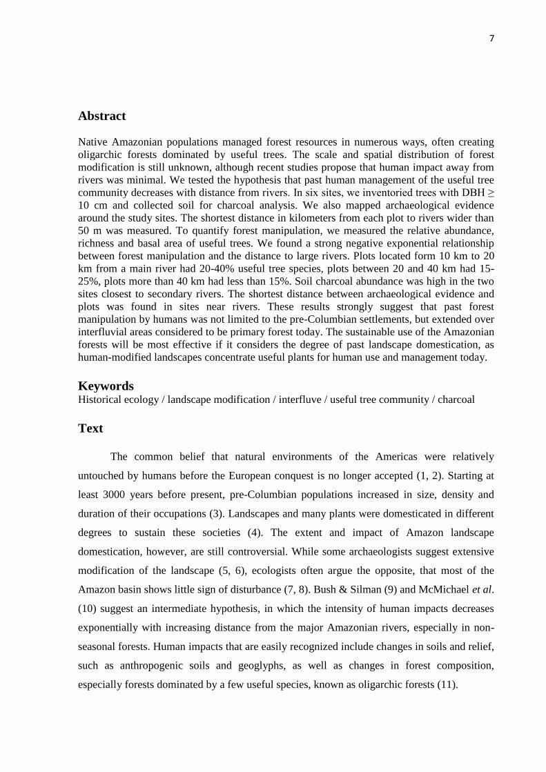
Archaeological evidence. Archaeological sites and anthropogenic forests were found inside
and around the six study sites, far from major rivers (Fig. 1). All sites with ADE were on the
10
banks of secondary rivers (> 50 m wide) and had not previously been identified, e.g.,
WinklerPrins and Aldrich (13). Castanhais and caiauezais are mostly near river banks, but
also occurred in the interior; they varied considerably in size and density. In the sites closest
to rivers, there were shorter distances between the archaeological evidences and the sampling
plots, and more evidences in general, as expected from the hypothesis.
Fig. 1.The large map shows the central-northern Purus-Madeira interfluve. The empty squares are the six
sampling sites at different distances from major rivers. In each site, two plots were sampled for floristic analysis
and five for charcoal analysis. Yelow triangles are caiauezais, green circles are castanhais (Brazil nuts > 1
individual/hectare) and red stars are ADE (terra preta sites). ADE data from WinklerPrins and Aldrich (13),
castanhais from RADAMBRASIL (27) and caiauezais from Moretzsohn et al. (28). The other six maps show

11
the newly identified terra preta sites (ADE) and anthropogenic forests in the vicinity of each site, identified by
interviews with local residents or by observation.
Charcoal in the soil. Macroscopic charcoal particles were recorded in all areas and in all soil
layers down to 50 cm (Fig. 2). Only in the 30-40 cm layer at site 6 was charcoal absent.
Higher values of charcoal were detected in the sites closest to secondary rivers. At M1 the
charcoal mass was high in the top 20 cm soil depth. Charcoal particles were abundant in all
layers at M2, 36 km from the main river, and the mean was much higher than the median
value observed by Piperno and Becker (29) in upland forest soils 90 km north of Manaus in
Central Amazonia, which is thought to be the value expected in soils without past human
activities. All other sites had charcoal close to the median value.
Fig. 2. Mass of charcoal in the soil (mg/cm
3) for each soil layer from 10 cm to 50 cm in depth. The plots are in
order of increasing distance from the sites to the rivers, expressed by the index of rivers distance. Each point is
the average mass of charcoal in the soil from 14-15 samples in each area. The vertical lines represent the
standard deviation. The dotted line represents the median value of the mass of charcoal found at each depth in
the soil of forests north of Manaus in Central Amazonia, which is the value expected in soils without past human
activities (29).
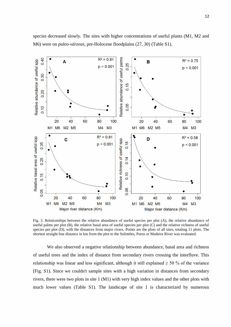
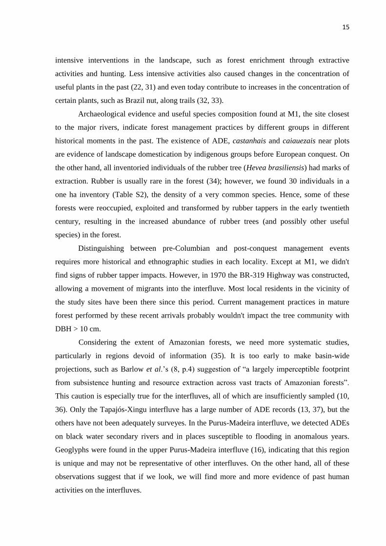
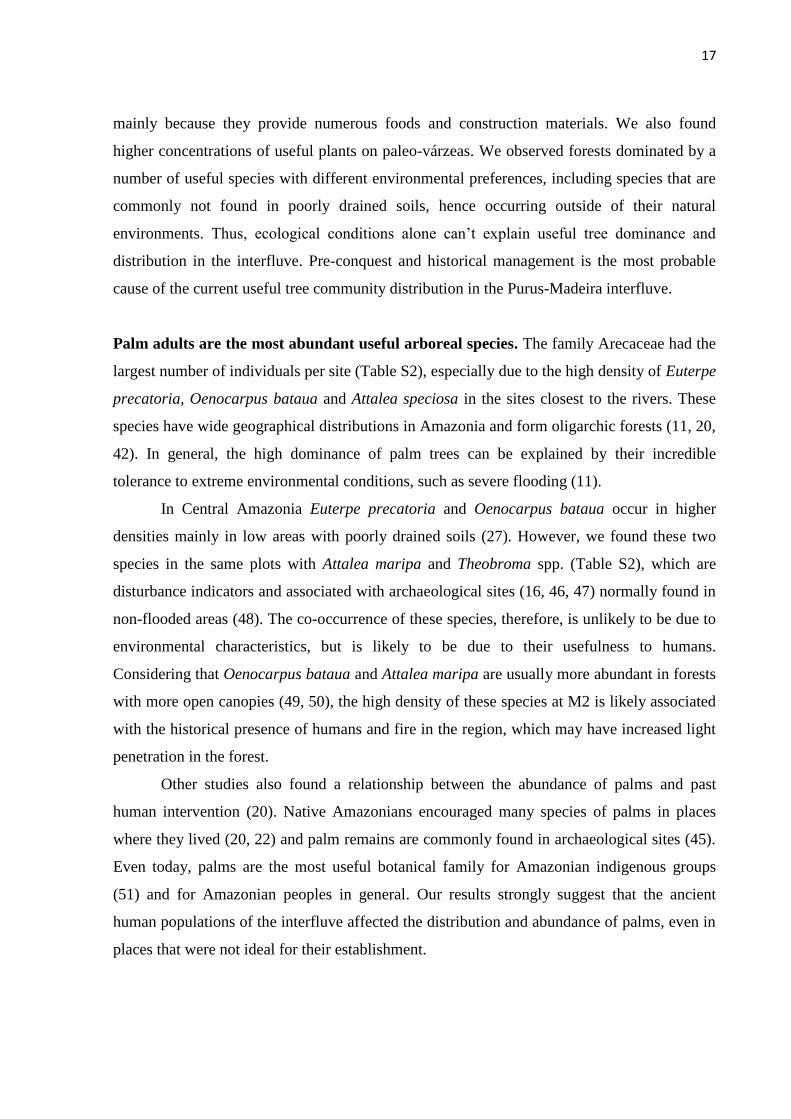
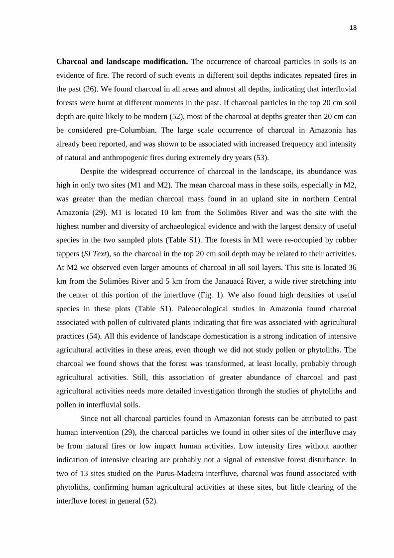
Relationship between the useful tree and palms community and the distance from rivers.
The relative abundance, basal area and richness of useful trees decreased with distance from
major rivers (Fig. 3). The relationship between these variables was a highly significant
negative exponential curve. Plots located from 10 to 20 km from a major river had 20-40%
useful tree species, plots with distances between 20 and 40 km had 15-25%, plots more than
40 km had less than 15%. In the first 20 km from major rivers there was a rapid decrease in
useful tree species and individuals. Beyond 40 km, the proportions of useful individuals and
12
species decreased slowly. The sites with higher concentrations of useful plants (M1, M2 and
M6) were on paleo-várzeas, pre-Holocene floodplains (27, 30) (Table S1).
Fig. 3. Relationships between the relative abundance of useful species per plot (A), the relative abundance of
useful palms per plot (B), the relative basal area of useful species per plot (C) and the relative richness of useful
species per plot (D), with the distances from major rivers. Points are the plots of all sites, totaling 11 plots. The
shortest straight line distance in km from the plot to the Solimões, Purus or Madeira River was evaluated.
We also observed a negative relationship between abundance, basal area and richness
of useful trees and the index of distance from secondary rivers crossing the interfluve. This
relationship was linear and less significant, although it still explained ≥ 50 % of the variance
(Fig. S1). Since we couldn't sample sites with a high variation in distances from secondary
rivers, there were two plots in site 1 (M1) with very high index values and the other plots with
much lower values (Table S1). The landscape of site 1 is characterized by numerous

13
Amazonian Dark Earth sites and anthropogenic forests, as well as by rivers and lakes (Fig. 1)
that were and still are waterways used for movement and fishing.
In order to focus on the influence of the secondary rivers, we reanalyzed the relationship
between the distance to secondary rivers and useful tree parameters, excluding plots from the
two sites closest to the main rivers, M1 and M6 (Fig. 4). This analysis showed that the
abundance and the basal area of useful species in areas away from major rivers is closely
related to their distance to secondary rivers, suggesting that the secondary rivers were also
occupied by pre-Columbian populations.
Fig. 4. Relationships between the relative abundance of useful species per plot (A), the relative abundance of
useful palms per plot (B), the relative basal area of useful species per plot (C) and the relative richness of useful
species per plot (D), with the distances from rivers. Points are the plots of sites M2, M3, M4, M5, totaling seven
plots. The index of rivers distances is the sum of the inverse distances from each plot to all perennial rivers
greater than 50 m wide in a 25 km diameter zone around the sites.
Palms. Arecaceae were the most abundant useful family in all plots (Table S1). The
relationship between the relative abundance of palms and the distance to rivers was as strong

14
as the relationship for all useful species together (Fig. 3B and 4B). Excluding the useful
palms, the relationship between the abundance of dicotyledonous trees and the distance to
major rivers was less significant (p = 0.05). A multiple regression analysis of the relationship
between the relative abundance of useful palms with the distance from rivers and the
hydrologic gradient indicated a strong effect of the distance from rivers (p = 0.001, Fig. 5)
and a significant effect of the hydrologic gradient on the abundance of useful palms (p = 0.05,
Fig. 5). The hydrologic gradient was not the major determinant of useful palm abundance in
the interfluve, and a large fraction of variance is attributable to distance per se, which is our
proxy for anthropogenic effects.
Fig. 5. Partial regressions between the relative abundance of useful palms and the distance of each plot to the
Solimões, Purus and Madeira Rivers (left) and the hydrologic gradient (right). The full multiple regression
model has an R2 = 0.73.
Discussion
Human intervention in the landscape decreases with distance from rivers. Our data
confirm McMichael et al. (10) hypothesis and the expectations of Bush & Silman (9) that
human intervention in the landscape decreases with distance from major and secondary rivers.
However, the extent of human impact in the forest observed in our study is much greater than
expected by these authors and the assumptions of Peres et al. (7) and Barlow et al. (8). We
found high abundances of useful tree species up to 20 km into the interfluve, and also the
presence of anthropogenic forests and Amazonian Dark Earths far from the major rivers, but
close to secondary rivers. Studies that only assessed past human disturbance in terms of
charcoal, pollen and phytoliths of cultivated plants (9, 10) failed to detect signals of less
15
intensive interventions in the landscape, such as forest enrichment through extractive
activities and hunting. Less intensive activities also caused changes in the concentration of
useful plants in the past (22, 31) and even today contribute to increases in the concentration of
certain plants, such as Brazil nut, along trails (32, 33).
Archaeological evidence and useful species composition found at M1, the site closest
to the major rivers, indicate forest management practices by different groups in different
historical moments in the past. The existence of ADE, castanhais and caiauezais near plots
are evidence of landscape domestication by indigenous groups before European conquest. On
the other hand, all inventoried individuals of the rubber tree (Hevea brasiliensis) had marks of
extraction. Rubber is usually rare in the forest (34); however, we found 30 individuals in a
one ha inventory (Table S2), the density of a very common species. Hence, some of these
forests were reoccupied, exploited and transformed by rubber tappers in the early twentieth
century, resulting in the increased abundance of rubber trees (and possibly other useful
species) in the forest.
Distinguishing between pre-Columbian and post-conquest management events
requires more historical and ethnographic studies in each locality. Except at M1, we didn't
find signs of rubber tapper impacts. However, in 1970 the BR-319 Highway was constructed,
allowing a movement of migrants into the interfluve. Most local residents in the vicinity of
the study sites have been there since this period. Current management practices in mature
forest performed by these recent arrivals probably wouldn't impact the tree community with
DBH > 10 cm.
Considering the extent of Amazonian forests, we need more systematic studies,
particularly in regions devoid of information (35). It is too early to make basin-wide
projections, such as Barlow et al.’s (8, p.4) suggestion of “a largely imperceptible footprint
from subsistence hunting and resource extraction across vast tracts of Amazonian forests”.
This caution is especially true for the interfluves, all of which are insufficiently sampled (10,
36). Only the Tapajós-Xingu interfluve has a large number of ADE records (13, 37), but the
others have not been adequately surveyes. In the Purus-Madeira interfluve, we detected ADEs
on black water secondary rivers and in places susceptible to flooding in anomalous years.
Geoglyphs were found in the upper Purus-Madeira interfluve (16), indicating that this region
is unique and may not be representative of other interfluves. On the other hand, all of these
observations suggest that if we look, we will find more and more evidence of past human
activities on the interfluves.

16
We expect that the footprints of past human activities in the forest will be found in
other parts of Amazonia given results in other areas of the world. Around ancient Roman
ruins in France, the composition and diversity of plants reflects the impacts of agriculture
1500 years after abandonment (38). In the Maya forests in Central America, past human
management of useful species was identified 1000 years after this civilization’s decline (39,
40). In Central Africa, current tree species composition and diversity still reflects human
disturbances after nearly four centuries (41). Our results showing a gradient of pre-Columbian
human manipulation in the forest from the major rivers into the interfluve agree with these
other studies. Using only simple regressions with distance to major and minor rivers, which
reflect the distance from possible pre-Columbian settlements we explained 50-80% of the
variation in the useful tree community. Therefore, our results suggest that past human impacts
in the forest extend over large areas considered primary forest today.
Ecological factors and past human management influence useful tree and palms
abundance and distribution. Ecological conditions can explain arboreal monodominance
without invoking the need for human dispersal, especially of some palm species, e.g.,
Mauritia flexuosa in swamp forests (42). A gradient of hydrological conditions runs from the
floodplain to the interfluve, and in wetlands the flood-level is a determinant of plant
distribution along this gradient (43). Also in upland forests, some palm species respond to the
hydrological condition of the soils (44). As we expected, we found in our multiple regression
model a significant effect of the hydrologic gradient on the abundance of useful palms.
However, the effect of the distance to rivers, even after partitioning out the effect of the
hydrologic gradient, was stronger, probably due to past human management.
If ecological conditions were the sole determinants of plant distributions in the
interfluve, we should find roughly the same useful communities on paleo-várzeas, which are
pre-Holocene floodplains with similar geomorphological and hydrological conditions.
Instead, we found different dominant useful species on these paleo-várzeas, which are known
to be naturally associated with very different ecological conditions (Euterpe precatoria,
Hevea brasiliense in M1, are naturally associated with riparian forests, and Bertholletia
excelsa, Attalea speciosa in M6, are naturally associated with upland forests; see also Table
S2).
Phillips et al. (45) quantified the importance of different forest types for traditional
populations in Peru and showed that the várzea and paleo-várzea forests are the most used,
17
mainly because they provide numerous foods and construction materials. We also found
higher concentrations of useful plants on paleo-várzeas. We observed forests dominated by a
number of useful species with different environmental preferences, including species that are
commonly not found in poorly drained soils, hence occurring outside of their natural
environments. Thus, ecological conditions alone can’t explain useful tree dominance and
distribution in the interfluve. Pre-conquest and historical management is the most probable
cause of the current useful tree community distribution in the Purus-Madeira interfluve.
Palm adults are the most abundant useful arboreal species. The family Arecaceae had the
largest number of individuals per site (Table S2), especially due to the high density of Euterpe
precatoria, Oenocarpus bataua and Attalea speciosa in the sites closest to the rivers. These
species have wide geographical distributions in Amazonia and form oligarchic forests (11, 20,
42). In general, the high dominance of palm trees can be explained by their incredible
tolerance to extreme environmental conditions, such as severe flooding (11).
In Central Amazonia Euterpe precatoria and Oenocarpus bataua occur in higher
densities mainly in low areas with poorly drained soils (27). However, we found these two
species in the same plots with Attalea maripa and Theobroma spp. (Table S2), which are
disturbance indicators and associated with archaeological sites (16, 46, 47) normally found in
non-flooded areas (48). The co-occurrence of these species, therefore, is unlikely to be due to
environmental characteristics, but is likely to be due to their usefulness to humans.
Considering that Oenocarpus bataua and Attalea maripa are usually more abundant in forests
with more open canopies (49, 50), the high density of these species at M2 is likely associated
with the historical presence of humans and fire in the region, which may have increased light
penetration in the forest.
Other studies also found a relationship between the abundance of palms and past
human intervention (20). Native Amazonians encouraged many species of palms in places
where they lived (20, 22) and palm remains are commonly found in archaeological sites (45).
Even today, palms are the most useful botanical family for Amazonian indigenous groups
(51) and for Amazonian peoples in general. Our results strongly suggest that the ancient
human populations of the interfluve affected the distribution and abundance of palms, even in
places that were not ideal for their establishment.
18
Charcoal and landscape modification. The occurrence of charcoal particles in soils is an
evidence of fire. The record of such events in different soil depths indicates repeated fires in
the past (26). We found charcoal in all areas and almost all depths, indicating that interfluvial
forests were burnt at different moments in the past. If charcoal particles in the top 20 cm soil
depth are quite likely to be modern (52), most of the charcoal at depths greater than 20 cm can
be considered pre-Columbian. The large scale occurrence of charcoal in Amazonia has
already been reported, and was shown to be associated with increased frequency and intensity
of natural and anthropogenic fires during extremely dry years (53).
Despite the widespread occurrence of charcoal in the landscape, its abundance was
high in only two sites (M1 and M2). The mean charcoal mass in these soils, especially in M2,
was greater than the median charcoal mass found in an upland site in northern Central
Amazonia (29). M1 is located 10 km from the Solimões River and was the site with the
highest number and diversity of archaeological evidence and with the largest density of useful
species in the two sampled plots (Table S1). The forests in M1 were re-occupied by rubber
tappers (SI Text), so the charcoal in the top 20 cm soil depth may be related to their activities.
At M2 we observed even larger amounts of charcoal in all soil layers. This site is located 36
km from the Solimões River and 5 km from the Janauacá River, a wide river stretching into
the center of this portion of the interfluve (Fig. 1). We also found high densities of useful
species in these plots (Table S1). Paleoecological studies in Amazonia found charcoal
associated with pollen of cultivated plants indicating that fire was associated with agricultural
practices (54). All this evidence of landscape domestication is a strong indication of intensive
agricultural activities in these areas, even though we did not study pollen or phytoliths. The
charcoal we found shows that the forest was transformed, at least locally, probably through
agricultural activities. Still, this association of greater abundance of charcoal and past
agricultural activities needs more detailed investigation through the studies of phytoliths and
pollen in interfluvial soils.
Since not all charcoal particles found in Amazonian forests can be attributed to past
human intervention (29), the charcoal particles we found in other sites of the interfluve may
be from natural fires or low impact human activities. Low intensity fires without another
indication of intensive clearing are probably not a signal of extensive forest disturbance. In
two of 13 sites studied on the Purus-Madeira interfluve, charcoal was found associated with
phytoliths, confirming human agricultural activities at these sites, but little clearing of the
interfluve forest in general (52).

19
In addition, charcoal analysis is not useful to detect the existence of human activities
not related to fire, such as planting useful species on trails inside the forest (32) and
discarding seeds while walking to extract fruit or while hunting (22, 31, 55). Even though we
did not find a considerable mass of charcoal in M6, useful species composition suggests a
history of intense human intervention at this site. Attalea speciosa, Astrocaryum aculeatum
and Bertholletia excelsa, indicators of anthropogenic forests (20, 23, 33, 46), were found in
the same plots as Astrocaryum murumuru and Elaeis oleifera, both related to ADE (56).
Understanding the past to conserve and manage for the future. Our study provides a new
and realistic view of the extension of the impacts caused by ancient Native Amazonians in a
forested landscape. We found a gradient of human manipulation in the forest from the rivers
into the Purus-Madeira interfluve. Since this interfluve is full of secondary and smaller rivers
crossing its interior, the effect of human manipulation should also be directly related to the
distance from these minor rivers. ADE in the vicinity of a secondary river, even more than 5
km away from the Madeira River, contains a unique species composition related to past
human activity when compared with non-anthropogenic soils (56). As most ecological studies
focus on the vicinity of navigable rivers (36), these studies need to incorporate the effect of
human history to better understand the patterns and mechanisms that explain biodiversity.
This issue has been raised previously (57, 58), but is still remarkably ignored by many
biologists and ecologists (59). Future research must associate floristic inventories with
paleoecological and archaeological data to build a more reliable view of the impact of pre-
Colombian populations in Amazonia, especially in other interfluvial areas.
Our results have important implications for the conservation and sustainable use of
forest resources today, contrary to the claims of Barlow et al. (8). Although Amazonia is
mostly sparsely populated and filled with apparently empty areas today, such as the
interfluves, people live in these forests in remote locations. These people, both indigenous and
peasant, depend on the forest’s resources for their well-being. We argue that the modifications
left by ancient Native Amazonians in the landscape and in the useful trees and palms
community are extremely important to plan sustainable practices for the use of these forests
today (60).
The strategies for Amazonian conservation, suggested by the National System of
Conservation Units (61), recognize the existence of people living within the forest and
extracting non-timber forest products (NTFP). Accordingly, forests that were managed and
20
enriched in the past have an important role for biodiversity conservation, as they concentrate
NTFPs that need to be sustainably managed by human populations today (62). Conservation
policy makers must also consider that Amazonian forests were domesticated in different
degrees. From this point of view, the role of traditional populations, with their management
practices, becomes crucial to ensure the conservation of the forest and the culture of the
people who live there.
Material and Methods
Study Area. The study was conducted in the interfluve between the Purus and Madeira rivers,
in the state of Amazonas, Brazil (Fig. 1), covering an area of approximately 90,000 km². The
study was carried out in mature lowland forests along the BR-319 Highway in six previously
installed sites of the Research Program in Biodiversity (PPBio) (63, for more details about the
sites see: http://ppbio.inpa.gov.br/Eng/inventarios/br319/). The sites are located at different
distances from the major rivers and in different environments. M1, M2 and M6 are on paleo-
várzeas, old floodplains formed during previous glacial periods (27, 30). The other sites are
on low plateaus (27).
Botanical Data. First, 10 plots were installed in each site by PPBio, one km from each other.
In five of them, all trees were marked and measured. We choose two of these five plots to
sample tree composition, considering the high topographic variation between plots, using
SRTM (Shuttle Radar Topography Mission) images. All trees and palms with diameter at
breast height (DBH) ≥ 10 cm were sampled in plots of 0.5 ha (250 x 20 m). Trees with DBH
≥ 30 cm were sampled in 1 ha plots (250 x 40 m). We inventoried trees with DBH ≥ 10 cm
because they may be descendants of pre-conquest management, since old trees that may have
been planted or promoted by ancient people will reproduce and their recruits will persist in
old anthropogenic forests. Ross (41) found small individuals of useful tree species (> 2.5 cm
DBH) in ancient Maya forest gardens after a millennium of abandonment, confirming this
expectation. The botanical material was pre-identified in the field by parataxonomists and
also collected for comparison with herbarium collections (INPA).
Charcoal Data. We surveyed soil characteristics, including charcoal, in 4-5 plots in each site,
for a total of 29 plots surveyed. Two of them are the same plots used for botanical analysis. At
the beginning, middle and end of each of the five plots, a small pit were excavated to 50 cm in

21
depth. Using a Kopecky cylinder (100 cm³), a horizontal collection of undisturbed soil was
made at 10 cm intervals. The soil was dried and then visible charcoal was removed for
weighing.
Distance Measures. The distances from botanical plots to rivers were calculated using
Landsat Thematic Mapper (TM) images. We considered a straight-line distance from the plot
to the closest major river (Solimões, Purus or Madeira). To measure the distance to smaller
rivers, a buffer zone with a 25 km radius around each plot was traced. We considered 25 km
the maximum distance that could be covered on foot leaving the center of occupation for long
hunting activities (64). Within each buffer, the shortest distance from the plot to perennial
rivers (greater than 50 m in width) was calculated. Only 50 m wide rivers were chosen, as
these represent the minimum width of navigable rivers in the region detected using TM
images. An index of rivers distances was calculated by the sum of all inverse distance values
from each plot to perennial rivers inside the 25 km buffer zone [index of rivers distances = 1 -
(1/distance river 1 + 1/distance river 2 + 1/distance river n)].
Hydrological Measures. The gradient of hydrological conditions between plots was
composed with two distinct measurements. One measured only in plots that flooded during
the rainy season. In these plots, we used the height of water marks on tree trunks left by the
highest water level in the previous year. In plots that did not flood we used another method to
measure the hydrological condition of the soil. For these plots, we installed a piezometer from
the soil surface to seven meters below the ground level. Then, the distance from the soil
surface to the highest groundwater level in March in 2011 was measured, as this is the period
with the highest groundwater level during the rainy season.
Data Analysis. To evaluate the relationship between useful “tree” parameters (abundance,
basal area, richness) and the distance to rivers we used simple linear regressions and nonlinear
regressions. For abundance and basal area parameters, the values of all trees and palms with
DBH < 30 cm in 0.5 ha were extrapolated to 1 ha. The dependent variables were: 1) the
relative abundance of useful trees – number of individual useful trees as a percentage of the
total number of individual trees per plot; 2) the relative richness of useful species – number of
useful species as a percentage of the total number of species per plot; and 3) relative basal
area occupied by useful species – basal area of useful species as a percentage of the total basal
22
area per plot. We used relative values of abundance, richness and basal area due to the high
variation in total numbers from one plot to another (Table S1). The shortest distance from
major rivers and the index of rivers distances, which reflect the ability of human movement
within the interfluve, were the independent variables used in the regressions.
Palm Analysis. In our study area, hydrological conditions seem to be an important factor
influencing the distribution and abundance of trees and palms. To determine if the patterns of
useful palm abundance observed are associated with environmental parameters, rather than
the distance from possible occupation sites, we used multiple regression models. These
models included the hydrological gradient as environmental predictor and the distance to
rivers as a predictor of human activity, and relative abundance of palms as response variable.
These two variables had a low Pearson correlation (r = 0.25, p = 0.46).
See SI Text for more details of study area, useful species, botanical identification and data
analysis.
Acknowledgments
We thank Alexandro Elias dos Santos and José Adailton Correa for field assistance and
Francislaide da Silva Costa, who helped with charcoal analysis. We sincerely thank the
residents of the BR-319 Highway for their hospitality and patience. The Research Program for
Biodiversity (PPBio) provided field installations and FAPEAM (Foundation to support
research in the state of Amazonas) (project no. 09/53369-6) provided financial support for
fieldwork. We thank Bernardo M. Flores, INPA, Mark M. Bush, Florida Inst. Technology,
André B. Junqueira and Marielos Pena-Claros, Wageningen University, and David Campbell,
Grinnell College, for suggestions to improve earlier versions of this manuscript. CL received
a post-graduate scholarship from CAPES (Coordination for the Improvement of Higher
Education), and this study is her master’s dissertation at INPA. CRC and FRCC thank the
Conselho Nacional de Desenvolvimento Científico e Tecnológico (CNPq) for research
fellowships.
References
23
1. Willis KJ, Gillson L, Brncic TM (2004) How “virgin” is virgin rainforest? Science
304:402–403.
2. Denevan WM (2011) The “Pristine Myth” revisited. Geogr Rev 101:576-591.
3. Piperno DR, Pearsall DM (1998) The Origins of Agriculture in the Lowland Neotropics
(Academic, San Diego).
4. Clement CR (1999) 1492 and the loss of Amazonian crop genetic resources. I: The relation
between domestication and human population decline. Econ Bot 53:188-202.
5. Erickson CL (2008) in Handbook of South American Archaeology, eds Silverman H, Isbell
WH (Springer, Berlin), pp 157-183.
6. Heckenberger MJ, et al. (2003) Amazonia 1492: Pristine forest or cultural parkland?
Science 301:1710–1714.
7. Peres CA, et al. (2010) Biodiversity conservation in human-modified Amazonian forest
landscapes. Biol Conserv 143(10):2314-2627.
8. Barlow J, Gardner TA, Lees AC, Parry L, Peres CA (2011) How pristine are tropical
forests? An ecological perspective on the pre-Columbian human footprint in Amazonia and
implications for contemporary conservation. Biol Conserv in press.
9. Bush MB, Silman MR (2007) Amazonian exploitation revisited: Ecological asymmetry and
the policy pendulum. Front Ecol Environ 5:457–465.
10. McMichael CH, et al. (2012) Spatial and temporal scales of pre-Columbian disturbance
associated with western Amazonian lakes. The Holocene 22(2):131-141.
11. Peters CM, Balick MJ, Kahn F, Anderson AB (1989) Oligarchic forests of economic
plants in Amazonia: utilization and conservation of an important tropical resource. Conserv
Biol 3(4):341–349.
12. Denevan WM (1996) A bluff model of riverine settlement in prehistoric Amazonia. Ann
Assoc Am Geogr 86(4):654-681.
13. WinklerPrins AMGA, Aldrich SP (2010) Locating Amazon Dark Earths: Creating an
interactive GIS of known locations. J Latin Am Geogr 9(3):33-50.
14. Woods WI, McCann JM (1999) in Yearbook. Conference of Latin American Geographers,
pp 7-14.
15. Neves EG, Peterson JB, Bartone RN, Silva CA (2003) in Amazonian Dark Earths –
Origin, Properties, and Management, eds Lehmann J, Kern D, Glaser B, Woods W (Kluwer
Academic Publ., Dordrecht), pp 29-50.
16. Pärssinen M, Schaan D, Ranzi A (2009) Pre-Columbian geometric earthworks in the
upper Purús: a complex society in western Amazonia. Antiquity 83:1084–1095.
24
17. Erickson CL, Balee W (2006) in Time and Complexity in Historical Ecology: Studies in
the Neotropical Lowlands, eds Balée W, Erickson CL (Columbia Univ Press, New York), pp
187-233.
18. Meggers BJ (1971) Amazonia: Man in a Counterfeit Paradise (Chicago: Aldine-
Atherton).
19. Junk WF, et al. (2011) A classification of major naturally-occurring Amazonian lowland
wetlands. Wetlands 31(4):623-640.
20. Balée W (1989) in Resource Management in Amazonia: Indigenous and Folk Strategies,
eds Posey DA, Balée W (The New York Botanical Garden, New York), pp 1–21.
21. Clement CR, McCann JM, Smith NJH (2003) in Amazonian Dark Earths – Origin,
Properties, and Management, eds Lehmann J, Kern D, Glaser B, Woods W (Kluwer
Academic Publ., Dordrecht), pp 159-178.
22. Peters, C. 2000. in Imperfect Balance: Landscape Transformations in the Pre-Columbian
Americas, ed Lentz D (Columbia Univ Press, New York), pp 203–223.
23. Shepard GH, Ramirez H (2011) ‘‘Made in Brazil’’: human dispersal of the Brazil nut
(Bertholletia excelsa, Lecythidaceae) in ancient Amazonia. Econ Bot 65:44–65.
24. Chambers JQ, Higuchi N, Schimel JP (1998) Ancient trees in Amazonia. Nature 391:135–
136.
25. Cunha RNV, et al. (2009) in Domesticação e Melhoramento: Espécies Amazônicas, eds
Borém A, Lopes MTG, Clement CR (Univ. Fed. Viçosa, Viçosa), pp 275-296.
26. Sanford RLJr, Horn SP (2000) Holocene rain-forest wilderness: A Neotropical
perspective on humans as an exotic, invasive species. USDA Forest Serv Proc RMRS 3:1-15.
27. Brazil (1978) Projeto RADAMBRASIL Folha SB.20 Purus; geologia, geomorfologia,
pedologia, vegetação e uso potencial da terra (Dept. Nacional Pesquisa Mineral, Rio de
Janeiro). 28. Moretzsohn MC, et al. (2002) Genetic diversity of Brazilian oil palm (Elaeis oleifera
H.B.K.) germplasm collected in the Amazon Forest. Euphytica 124:35–45.
29. Piperno DR, Becker P (1996) Vegetation history of a site in the central Amazon Basin
derived from phytolith and charcoal records from natural soils. Quat Res 45:202–209.
30. Irion G, et al. (2010) in Central Amazonian Floodplain Forests: Ecophysiology,
Biodiversity and Sustainable Management, eds Junk WJ, Piedade MTF, Wittmann F,
Schöngart J, Parolin P (Springer, Berlin), pp 27-42.
31. Guix JC (2005) Evidence of old anthropic effects in forests at the confluence of the
Caurés and Negro Rivers – NW Amazonia: The role of Indians and Caboclos. Grupo Estud.
Ecol. Sér. Doc. 8(1):1-27.
25
32. Posey DA (1985) Indigenous management of tropical forest ecosystems: the case of
Kayapó Indians of the Brazilian Amazon. Agrofor Syst 3:139–158.
33. Scoles R, Gribel R (2011) Population structure of Brazil nut (Bertholletia excelsa,
Lecythidaceae) stands in two areas with different occupation histories in the Brazilian
Amazon. Hum Ecol 39:455–464.
34. Souza AD, et al. (2011) in Fruit Trees and Useful Plants in Amazonian Life, eds Shanley
P, Cymerys M, Serra M, Medina G (FAO-CIFOR-PPI, Rome), pp 121-128.
35. Nelson BW, Ferreira CAC, Silva MF, Kawasaki ML (1990) Endemism centres, refugia
and botanical collection density in Brazilian Amazonia. Nature 345:714-716.
36. Pitman NCA, et al. (2011) Volume and geographical distribution of ecological research in
the Andes and the Amazon, 1995-2008. Trop Conserv Sci 4:64-81.
37. Smith NJH (1980) Anthrosols and human carrying capacity in Amazonia. Ann Assoc Am
Geogr 70(4):553-566.
38. Dambrine EJL, et al. (2007) Present forest biodiversity patterns in France related to
former Roman agriculture. Ecology 88:1430–1439.
39. Campbell DG, et al. (2006) in Time and Complexity in Historical Ecology: Studies in the
Neotropical Lowlands, eds Balée W, Erickson CL (Columbia Univ Press, New York), pp 21–
55.
40. Ross, NJ (2011) Modern tree species composition reflects Ancient Maya ‘forest gardens’
in NW Belize. Ecol Appl 21(1):75-84.
41. van Gemerden BS, Olff H, Parren MPE, Bongers F (2003) The pristine rain forest?
Remnants of historical human impacts on current tree species composition and diversity. J
Biogeogr 30: 1381–90.
42. Kahn F, Mejia K (1990) Palm communities in wetland forest ecosystems of Peruvian
Amazonia. For Ecol Manage 33/34:169-179.
43. Wittman F, Junk WJ, Piedade MTF (2004) The varzea forests in Amazônia: flooding and
the highly dynamic geomorphology interact with natural forest succession. Forest Ecol
Manag 196(2-3): 199-212.
44. Kahn F, Castro A (1985) The palm community in a forest of central Amazonia, Brazil.
Biotropica 17:210–216.
45. Phillips O, Gentry AH, Reynel C, Wilkin P, Galvez-Durand B (1994) Quantitative
ethnobotany and Amazonian conservation. Conserv Biol 8:225-248.
46. Balée W, Campbell DG (1990) Evidence for the successional status of liana forest (Xingu
River basin, Amazonian Brazil). Biotropica 22:36–47.

26
47. Morcote-Rios G, Bernal R (2001) Remains of palms (Palmae) at archaeological sites in
the new world: a review. Bot Rev 67:309–350.
48. Cavalcante PB (2010) Frutas Comestíveis na Amazônia, (Museu Paraense Emílio Goeldi,
Belém).
49. Salm R (2005) The importance of forest disturbance for the recruitment of the large
arborescent palm Attalea maripa in a seasonally-dry Amazonian forest. Biota Neotrop 5(1):1-
7.
50. Svenning JC (1999) Recruitment of tall arborescent palms in the Yasuni National Park,
Amazonian Ecuador: are large treefall gaps important? J Trop Ecol 15:355–366.
51. Prance GT, Balée W, Boom BM, Carneiro RL (1987) Quantitative ethnobotany and the
case for conservation in Amazonia. Conserv Biol 1(2):296-310.
52. McMichael CH, et al. (2012) Sparse pre-Columbian human habitation in Western
Amazonia. Science 336:1429-1431.
53. Sanford RL, Saldarriaga J, Clark K, Uhl C, Herrera R (1985) Amazon rainforest fires.
Science 227:53–55.
54. Bush MB, et al. (2007) Holocene fire and occupation in Amazonia: records from two lake
districts. Philos Trans R Soc Biol Sci 362:209–218.
55. López-Zent E, Zent S (2004) in Ethnobotany and Conservation of Biocultural Diversity,
eds Carlson TS, Maffi L (New York Botanical Garden, New York), pp 79-112.
56. Junqueira AB, Shepard Jr GH, Clement CR (2010) Secondary forests on anthropogenic
soils in Brazilian Amazonia conserve agrobiodiversity. Biodiv Conserv 19:1933–1961.
57. Clark DB (1996) Abolishing virginity. J Trop Ecol 12(5):735-739.
58. Wills KJ, et al. (2007) How can a knowledge of the past help to conserve the future?
Biodiversity conservation and the relevance of long-term ecological studies. Phil Trans R Soc
B 362:175–186.
59. Clement CR, Junqueira AB (2010) Between a pristine myth and an impoverished future.
Biotropica 42:534-536.
60. Heckenberger MJ, Russell JC, Toney JR, Schmidt MJ (2007) The legacy of cultural
landscapes in the Brazilian Amazon: Implications for biodiversity. Phil Trans R Soc B
362:197–208.
61. Brasil (2000) Sistema Nacional de Unidades de Conservação da Natureza – SNUC.
(Diario Oficial da União, Brasilia).
62. Scoles R, Gribel R (2012) The regeneration of Brazil nut tree in relation to nut harvest
intensity in the Trombetas River valley of Northern Amazonia, Brazil. For Ecol Manage
265:71-81.
27
63. Magnusson B, et al. (2008) A program for monitoring biological diversity in the Amazon:
an alternative perspective to threat-based monitoring. Biotropica 40:409-411.
64. Peres CA, Nascimento HS (2006) Impact of game hunting by the Kayapo of south-eastern
Amazonia: implications for wildlife conservation in tropical forest indigenous reserves.
Biodiv Conserv 15:2627–2653.
Supporting Information
Material and Methods
Study Area. Rainfall is high, ranging from 2300 mm in the southern portion of the interfluve
to 2750 mm in the north (1). There is an increase in seasonality from one to three months with
less than 100 mm of rain towards the south (2). The region is characterized by very flat
topography (1). The soils are mostly Plinthosols (FAO soil taxonomy), with hydromorphic
soils on the terraces and alluvial plains (3). Most soils are poorly drained during the rainy
season, causing flooding. The vegetation is defined as Dense Lowland Rainforest in the north
and Open Lowland Rainforest in the south (4). The BR 319 Highway, which connects the
cities of Manaus and Porto Velho, is the only access to the interfluve, allowing the placement
of sites in areas far from the major rivers.
History of human presence in the region. During the pre-colonial period, the main
indigenous ethnic group mentioned as inhabitants of the northern part of the region was the
Mura (5). With the arrival of Europeans, disputes over the territory and diseases resulted in
the deaths of most indigenous people (6). In the late nineteenth century, the Madeira River
was reoccupied for the production of latex extracted from the rubber tree (Hevea brasiliensis),
which collapsed in 1920. Fifty years later, the region experienced a new process of population
expansion with the construction of the BR-319 Highway, allowing a movement of migrants
into the interfluve. Currently, the road is almost impassable in most parts (only the northern
and southern sections are used regularly), and most people live in cities and small towns near
rivers. However, the BR-319 road is being repaved. Consequently, the region will experience
another expansion process.
Kern et al. (7) report some patches of Amazonian Dark Earth (ADE) along the Purus
River. Most of them are present in the southern portion of this river’s basin. However, the

28
lower Purus, where it empties into the Solimões River, is part of the largest known center of
past human occupation in Central Amazonia (8). On the banks of the Madeira River and its
tributaries, a large number of archaeological sites with ADE were also found (9).
Furthermore, the lower Madeira River also has high crop genetic diversity (10). Despite the
lack of information about the extent of anthropogenic forests in the interfluve, there is
abundant evidence of domesticated landscapes (André B. Junqueira, unpublished data). Most
of this evidence is present in areas closest to the main rivers.
Mapping Archaeological Evidence. Archaeological evidence and anthropogenic forests
were identified and mapped around each research site. The main evidence of pre-modern
human activities documented were Amazonian Dark Earths (ADE) and two types of
anthropogenic forests, the castanhais and caiauezais. The identification of ADE and
anthropogenic forests was obtained by interviews with local residents and, when possible,
GPS coordinates were recorded on site. Characteristics of the evidence, such as the presence
of archaeological artifacts (ceramics and lithics), were documented.
Useful Species. To create the list of useful species considered in this study, we used the most
important papers in ethnobotany and previous inventories in anthropogenic forests (10-18) in
Amazonian forests and archeological sites. The useful species mentioned in at least two
studies were included in the list. We also considered their degree of domestication (10), their
use as food resources in the daily diet of human populations during long periods in the forest
for game hunting or other activities, and also their capacity to attract game. Species with
commercial value in the post-colonial period, such as Hevea brasiliensis and Carapa
guianensis, were also included in the list.
Collection of botanical data. At M4, only two plots had been installed at collection time, and
one of them is located less than 500 meters from the highway and on the edge of a shifting
cultivation plot. We intended to work only in mature forest, so we excluded this plot from
analysis.
After a preliminary identification in the field with the aid of parataxonomists, the
botanical identification was confirmed by Priscila Souza, graduate student in Botany at INPA,
specialists, identification guides and by comparing the vouchers collected to specimens at the
INPA Herbarium (Manaus, Brazil) and virtual herbariums
(http://fm1.fieldmuseum.org/vrrc/index.php, http://sciweb.nybg.org/science2/vii2.asp). Fertile
specimens will be deposited at INPA and sterile material will be deposited at EAFM. Floristic

29
and charcoal data will be available on the PPBio web site
(http://ppbio.inpa.gov.br/Eng/inventarios/br319/) and may be requested from the first author.
Results
Archaeological and anthropogenic forest evidence. The M1 site had the highest number
and diversity of evidence (Fig. 1). Castanhais and caiauezais were close to the studied plots
(Table S1). ADE was only 4 km from the plots and was located in a soil susceptible to
flooding in years with very intense floods. M2 was close to one castanhal and the Janauacá
River. Local residents affirm that there are many ADE sites around Janauacá Lake, but they
have not yet been mapped. At M3 and M4, ADE was only mapped more than 10 km from the
sites at the Igapó Açu River, which is the longest river in the interfluve. No ADE was mapped
near M6, but this was the only site with Brazil nut trees, caiaué and other domesticated plants
within the sampled plots (Table S2). At M5, castanhais were mapped close to the plot at the
edge of a watercourse connected with the Acará River. According to local residents, this river
was occupied by Mura Indians in the past and numerous Brazil nut trees occur on its banks.
Useful species. We found 34 useful species from 14 different botanical families. The highest
abundance of useful species was found in one plot of M1, the closest to a major river, the
Solimões, and the lowest abundance was found at M4, located in an upland forest, 80 km
from the Madeira River (Table S1). The five useful species with the largest number of
individuals in M1 were Euterpe precatoria, Hevea brasiliensis, Carapa guianensis, Inga spp.
and Anacardium parvifolium; in M6, Attalea speciosa, Euterpe precatoria, Astrocaryum
murumuru, Oenocarpus bataua and Pseudolmedia laevis; and in M2, Oenocarpus bataua,
Tapirira guianensis Micropholis guyanensis, Helicostylis tomentosa and Theobroma spp.
(Table S2). These three sites have different useful dominant species.
Table S1. Means and standard deviations of all botanical data and distances measured in the six study sites
along the Purus-Madeira interfluve, Amazonas, Brazil. M4 does not have a standard deviation because one plot
was discarded.
M1 M2 M3 M4 M5 M6
Abundance of all useful species¹ 195,5 ± 36,5 131 ± 13 75 ± 19 42 69,5 ± 10,5 132,5 ± 5,5
Total abundance 520 ± 39 614 ±39 661,5 ±1 28,5 588 551,5 ± 41,5 531,5 ± 76,5
Abundance of useful palms trees 133,5 ± 27,5 84 ±26 19 ± 3 8 28 ± 4 85,5 ± 2,5
Abundance of useful dicotyledonous 62 ± 9 47 ± 13 56 ± 22 34 41,5 ± 6,5 47 ± 3

30
Basal area of all useful species²
(m²/ha) 7,47 ± 1,64 3,6 ± 0,14 2,40 ± 0,39 1,67 3,67 ± 0,27 7,16 ± 2,74
Total basal area (m²/ha) ³ 19,99 ± 2,03 22,27 ± 0,31 23,37 ±2 ,01 26,92 24,22 ± 2,67 25,35 ± 3,13
Richness of all useful species 9 ± 1 12 ± 1 14 10 11,5 ± 1,5 12 ± 1
Total richness 44,5 ± 4,5 142 ± 9 164,5 ± 4,5 164 76 ± 1 90 ± 2
Distance from main rivers (km) 11 ± 0,5 36 91,5 ± 0,5 80 39,5 ± 0,5 18,5 ± 0,5
Index of distance (-)0,06 ± 0,04 0,58 ± 0,03 0,87 ± 0,01 0,93 0,79 ± 0,02 0,77
Distance from ADE (km) 5 ± 0,7 33,0 23 31 - 37
Distance from Anthropogenic Forest
(km) 0,5 3,0 13 ± 1,4 15 3 ± 0,7 0,5 ± 0,7
¹ The values of species abundance are the number of all useful trees and palms with DBH ≥ 10 cm in 1 ha.
² The value of species basal area are the basal area of all useful trees and palms with DBH ≥ 10 cm in 1 ha.
³ The values of species richness are the sum of all trees species with DBH ≥ 10 and < 30 cm in 0.5 ha and the
largest in 1 ha plot.
Fig. S1. Relationships between the relative abundance of useful species (A), the relative abundance of useful
palms (B), the relative basal area of useful species (C) and the relative richness of useful species (D) with the
distance from rivers. Points are the plots of all sites, totaling 11 plots. The index of rivers distances is the sum of
the inverse distances from each plot to all perennial rivers greater than 50 m wide in a 25 km diameter zone
around the sites. Since we couldn't sample sites with a high variation in distances from secondary rivers, there
were two plots in site 1 (M1) with very high index values and the other plots with much lower values.

31
Table S2. List of useful species found in 11 plots and their respective abundances along the Purus-Madeira interfluve, Amazonas, Brazil.
Species Family Common
name
Degree of
domestication M1.1 M1.1 M2.1 M2.2 M3.1 M3.2 M4 M5.1 M5.2 M6.1 M6.2
Anacardium parvifolium Ducke Anacardiaceae cajuí - 8 4 0 0 0 0 0 0 0 0 0
Astrocaryum aculeatum G.Mey. Arecaceae tucumã
semi-
domesticated 0 0 0 0 0 0 0 0 0 8 0
Astrocaryum murumuru Mart. Arecaceae muru-muru incipiently 2 4 4 0 0 0 0 0 0 0 18
Attalea speciosa Mart. ex Spreng. Arecaceae babaçú - 2 0 0 0 0 0 0 8 12 70 35
Attalea maripa (Aubl.) Mart. Arecaceae inajá incipiently 0 0 6 6 2 2 0 0 0 0 0
Bertholletia excelsa Bonpl. Lecythidaceae castanheira incipiently 0 0 0 0 0 0 0 0 0 10 2
Carapa guianensis Aubl. Meliaceae andiroba - 9 23 0 0 1 2 0 4 0 0 0
Caryocar glabrum (Aubl.) Pers. Caryocaraceae pequiarana - 0 0 0 0 0 0 2 1 4 4 4
Copaifera multijuga Hayne Fabaceae copaiba - 0 0 0 0 0 2 0 2 6 0 2
Couepia guianensis Aubl. Chrysobalanaceae pajurá - 0 0 0 0 0 0 0 0 0 10 0
Couma macrocarpa Barb.Rod. Apocynaceae sorva - 0 0 0 3 2 0 4 5 0 0 0
Dipteryx odorata (Aubl.) Willd. Fabaceae cumarú - 0 0 0 0 2 3 0 0 0 0 3
Ecclinusa guianensis Eyma Sapotaceae guajaraí - 0 0 0 2 0 13 2 2 7 2 7
Elaeis oleifera (Kunth) Cortés Arecaceae caiaué incipiently 0 0 0 0 0 0 0 0 0 0 2
Endopleura uchi (Huber) Cuatrec. Humiriaceae uxí - 0 0 0 0 4 0 2 0 1 1 0
Euterpe precatoria Mart. Arecaceae açaí - 102 157 6 0 0 0 0 20 12 8 12
Garcinia sp.1 L. Clusiaceae bacuri - 0 0 0 0 0 4 0 0 0 0 0
Helicostylis tomentosa (Poepp. & Endl.)
Rusby Moraceae
inharé - 0 0 4 14 0 7 10 12 5 0 0
Hevea brasiliensis (Willd. ex A.Juss.)
Müll.Arg. Euphorbiaceae
seringueira incipiently 7 30 0 0 6 13 0 2 3 0 0
Hymenaea parvifolia Huber Fabaceae jutaí - 10 0 0 0 0 0 0 0 0 0 0
Inga gracilifolia Ducke Fabaceae inga - 7 0 0 2 2 0 0 0 0 0 0
Inga alba (Sw.) Willd. Fabaceae inga - 0 4 0 0 1 0 0 0 0 0 0
Manilkara bidentata (A.DC.) A.Chev. Sapotaceae massaranduba - 0 0 0 0 0 3 0 6 2 0 0
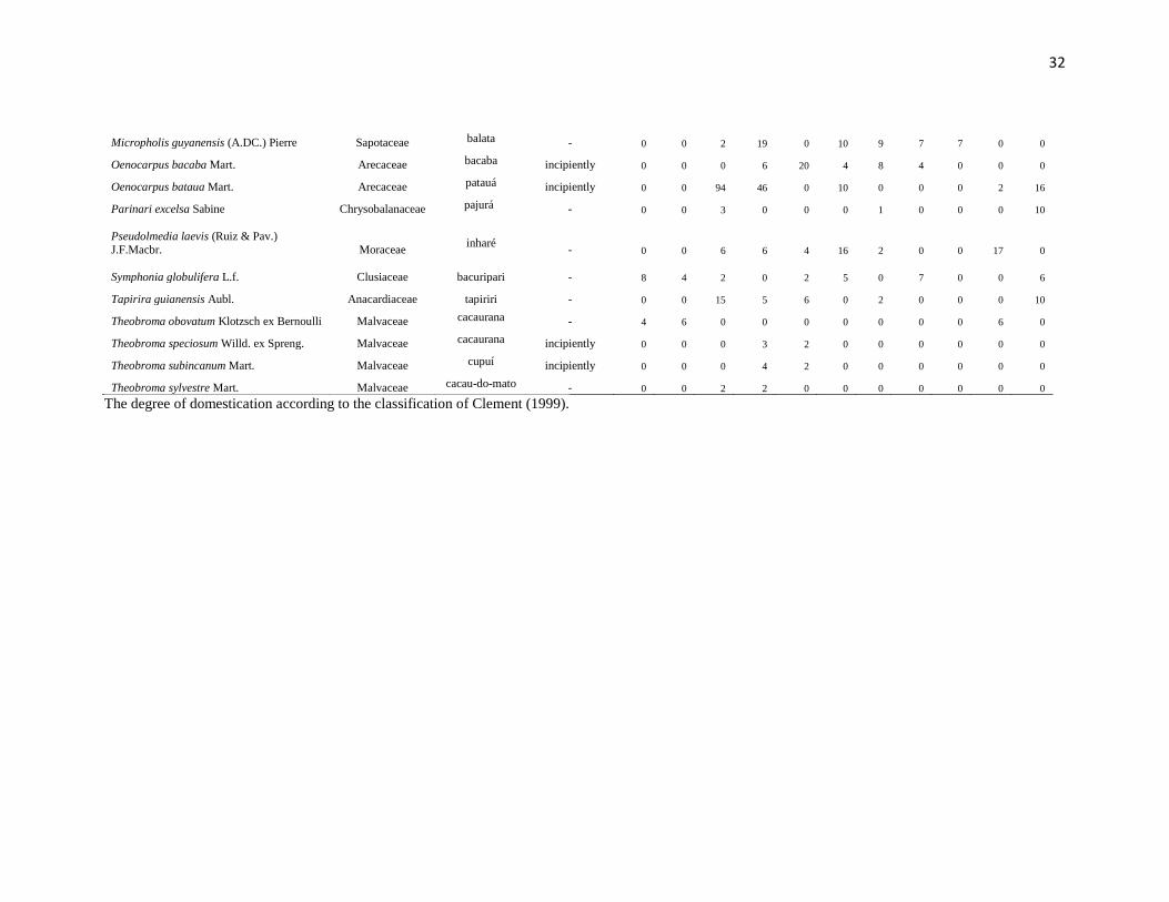
32
Micropholis guyanensis (A.DC.) Pierre Sapotaceae balata - 0 0 2 19 0 10 9 7 7 0 0
Oenocarpus bacaba Mart. Arecaceae bacaba incipiently 0 0 0 6 20 4 8 4 0 0 0
Oenocarpus bataua Mart. Arecaceae patauá incipiently 0 0 94 46 0 10 0 0 0 2 16
Parinari excelsa Sabine Chrysobalanaceae pajurá - 0 0 3 0 0 0 1 0 0 0 10
Pseudolmedia laevis (Ruiz & Pav.) J.F.Macbr. Moraceae
inharé - 0 0 6 6 4 16 2 0 0 17 0
Symphonia globulifera L.f. Clusiaceae
bacuripari - 8 4 2 0 2 5 0 7 0 0 6
Tapirira guianensis Aubl. Anacardiaceae tapiriri - 0 0 15 5 6 0 2 0 0 0 10
Theobroma obovatum Klotzsch ex Bernoulli Malvaceae cacaurana - 4 6 0 0 0 0 0 0 0 6 0
Theobroma speciosum Willd. ex Spreng. Malvaceae cacaurana incipiently 0 0 0 3 2 0 0 0 0 0 0
Theobroma subincanum Mart. Malvaceae cupuí incipiently 0 0 0 4 2 0 0 0 0 0 0
Theobroma sylvestre Mart. Malvaceae cacau-do-mato - 0 0 2 2 0 0 0 0 0 0 0
The degree of domestication according to the classification of Clement (1999).
33
References
1. Brazil (1978) Projeto RADAMBRASIL Folha SB.20 Purus; geologia, geomorfologia,
pedologia, vegetação e uso potencial da terra (Dept. Nacional de Pesquisa Mineral, Rio de
Janeiro).
2. Sombroek W (2001) Spatial and temporal patterns of Amazon rainfall. Ambio 30:388-
396.
3. Quesada, et al. (2011) Soils of Amazonia with particular reference to the RAINFOR
sites. Biogeosciences 8:1415–1440.
4. IBGE (1997) Recursos naturais e meio ambiente: uma visão do Brasil, (Instituto
Brasileiro de Geografia e Estatística,). 5. Cunha MMLC (1992) História dos Indios no Brasil (Companhia das Letras, São Paulo).
6. O'Fallon BD, Fehren-Schmitz L (2011) Native Americans experienced a strong
population bottleneck coincident with European contact. Proc Natl Acad Sci USA
108(51):20444-20448.
7. Kern D, et al. (2003) in Lehmann J, Kern D, Glaser B, Woods W (Eds.), Amazonian
Dark Earths ‐ Origin, Properties and Management. (Kluwer Academics Publisher,
Dordrecht), pp 51‐75.
8. Neves EG, Petersen JB (2006) in Time and Complexity in Historical Ecology: Studies in
the Neotropical Lowlands, eds Balée W, Erickson CL (Columbia Univ Press, New York),
pp 279–309.
9. WinklerPrins AMGA, Aldrich SP (2010) Locating Amazon Dark Earths: Creating an
interactive GIS of known locations. J Latin Am Geogr 9(3):33-50.
10. Clement CR (1999) 1492 and the loss of Amazonian crop genetic resources. I: The
relation between domestication and human population decline. Econ Bot 53:188-202.
11. Prance GT, Balée W, Boom BM, Carneiro RL (1987) Quantitative ethnobotany and the
case for conservation in Amazonia. Conserv Biol 1(2):296-310.
12. Balée W (1989) in Resource Management in Amazonia: Indigenous and Folk
Strategies, eds Posey DA, Balée W (New York Botanical Garden, New York), pp 1–21.
13. Cavalcante PB (2010) Frutas Comestíveis na Amazônia (Museu Paraense Emílio
Goeldi, Belém).
34
14. Balée W, Campbell DG (1990) Evidence for the successional status of liana forest
(Xingu River basin, Amazonian Brazil). Biotropica 22:36–47.
15. Guix JC (2005) Evidence of old anthropic effects in forests at the confluence of the
Caurés and Negro Rivers – NW Amazonia: The role of Indians and Caboclos. Grupo
Estud. Ecol. Sér. Doc. 8(1):1-27.
16. Balée W (2010) Contingent diversity in anthropic landscapes. Diversity, 2: 163–181.
17. Junqueira AB, Shepard Jr GH, Clement CR (2010) Secondary forests on anthropogenic
soils in Brazilian Amazonia conserve agrobiodiversity. Biodiv Conserv 19:1933–1961.
18. Junqueira AB, Shepard GH, Clement CR (2011) Secondary forests on anthropogenic
soils of the Middle Madeira River: Valuation, local knowledge, and landscape
domestication in Brazilian Amazonia. Econ Bot 65: 85-99.

35
Conclusão
O estudo contribuiu para produzir uma imagem mais realista da dimensão
geográfica dos impactos das antigas populações da Amazônia na paisagem. Somente
utilizando regressões simples com a distância dos grandes rios e dos rios menores foi
possível explicar 50 a 80% da variação da proporção de espécies úteis no interflúvio Purus-
Madeira. Nossos resultados indicam um gradiente de impacto humano na floresta saindo
dos grandes rios e adentrando o interflúvio. Como o interflúvio está repleto de rios em seu
interior, o efeito da manipulação humana também deve estar diretamente relacionado à
distância desses rios. Se os estudos ecológicos concentram-se na proximidade dos rios
principais (Pitman et al. 2011), há necessidade desses estudos incorporarem o efeito
humano histórico para melhor compreensão dos padrões e mecanismos que explicam a
biodiversidade atual. Este tema já foi levantado em publicações anteriores (Clark 1996,
Wills et al. 2007), mas tem sido notavelmente ignorado pelos biólogos e ecólogos (Clement
e Junqueira 2010). Pesquisas futuras precisam associar inventários florísticos com dados
paleoecológicos e arqueológicos para construirmos uma imagem mais confiável do impacto
das populações pré-colombianas na Amazônia, e como este passado ainda molda a
biodiversidade atual.
Nossos resultados têm uma importante implicação para a conservação e uso
sustentável dos recursos florestais atuais. Apesar de a Amazônia ser considerada uma
região pouco populosa e cheia de vazios demográficos, principalmente nos interflúvios,
existiam e ainda existem pessoas vivendo no interior da floresta em locais remotos. A vida
dessas pessoas e das populações ribeirinhas e indígenas da Amazônia dependem da
manutenção da floresta e de seus recursos. Acreditamos que o impacto e as marcas
deixadas pelas antigas populações na paisagem e na composição florística atual são
extremamente importantes para buscarmos práticas sustentáveis de utilização dessas
florestas (Heckenberg et al. 2007, McKey et al. 2010).
As estratégias para a conservação da Amazônia sugeridas no Sistema Nacional de
Unidades de Conservação (SNUC 2001) reconhecem a existência de pessoas que vivem na
36
floresta e dependem da extração de produtos florestais não-madeireiros (PFNM). Nesta
perspectiva, as florestas que eram manejadas e enriquecidas no passado têm um importante
papel na conservação da biodiversidade, já que concentram PFNM que, em certos casos,
precisam continuar sendo manejados para se perpetuarem (Scoles e Gribel 2012). A partir
desse ponto de vista, o papel das populações tradicionais torna-se crucial para a
manutenção das práticas de manejo que, por sua vez, possam assegurar a floresta e as
pessoas que nela vivem.

37
Apêndices
APÊNDICE A – Ata da Defesa presencial
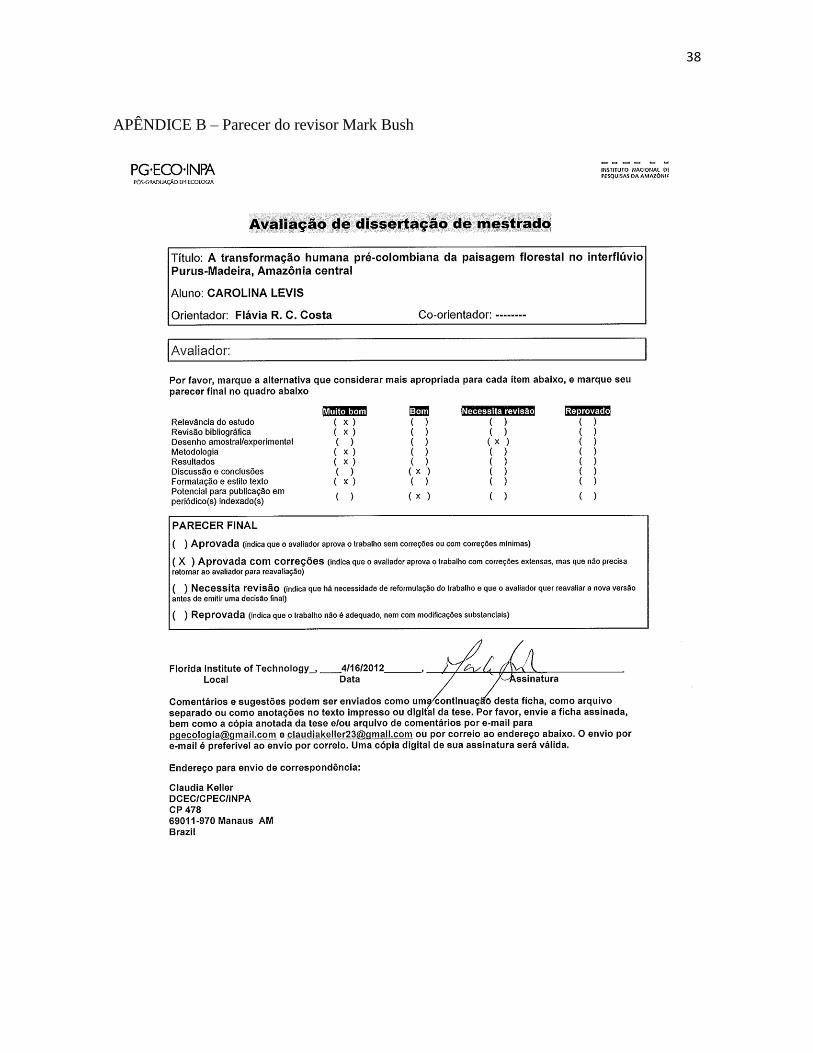
38
APÊNDICE B – Parecer do revisor Mark Bush
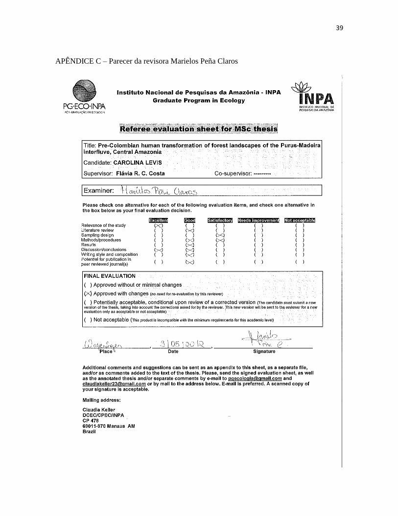
39
APÊNDICE C – Parecer da revisora Marielos Peña Claros
40
APÊNDICE D – Parecer do revisor David G. Campbell
41
APÊNDICE E – Ata da aula de qualificação