Embed Size (px)
Citation preview
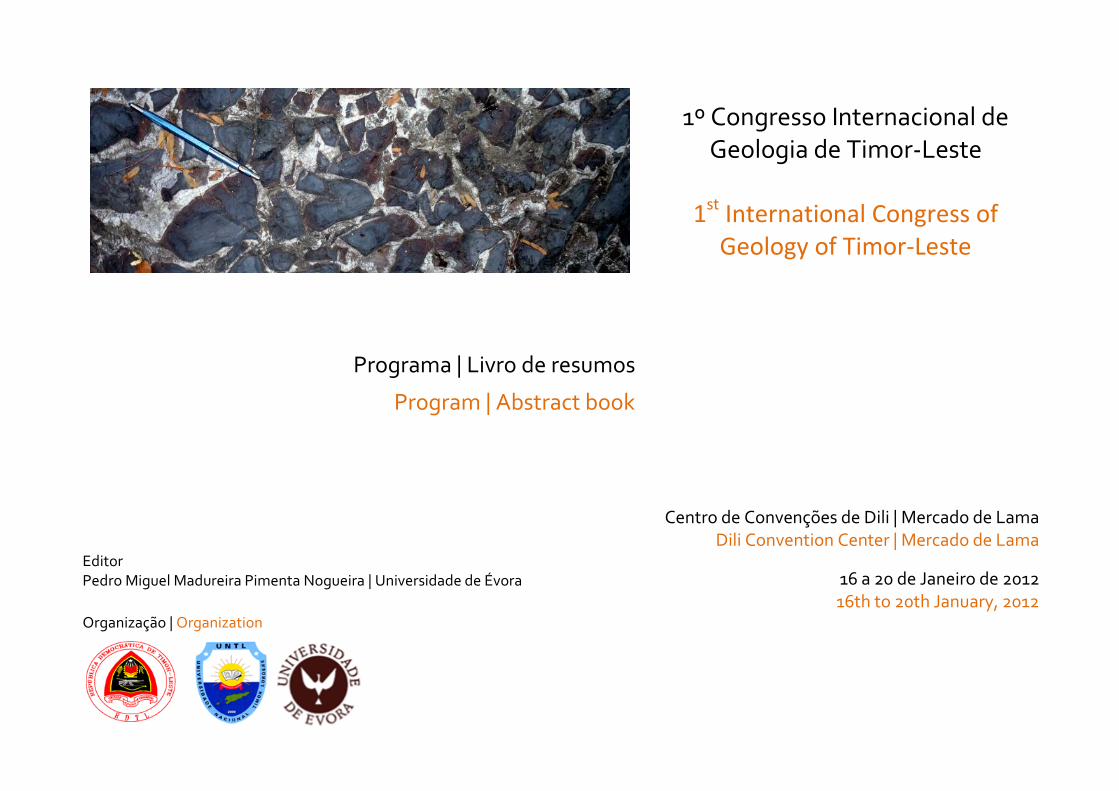
1º Congresso Internacional de Geologia de Timor-Leste
1st International Congress of Geology of Timor-Leste
Programa | Livro de resumos
Program | Abstract book
Centro de Convenções de Dili | Mercado de Lama Dili Convention Center | Mercado de Lama
Editor Pedro Miguel Madureira Pimenta Nogueira | Universidade de Évora 16 a 20 de Janeiro de 2012
16th to 20th January, 2012
Organização | Organization
Ficha técnica:
Título: 1º Congresso Internacional de Geologia de Timor-Leste: Livro de Resumos
Editor: Pedro Miguel Madureira Pimenta Nogueira | Universidade de Évora
Entidades promotoras: Secretaria de Estado dos Recursos Naturais | Universidade Nacional Timor Lorosa’e | Universidade de Évora
Composição e design gráfico: Dália Cristovão
ISBN: 978-989-8550-01-9
Tiragem: 468 exemplares
Dili | Janeiro de 2012
Factsheet:
Title: 1st International Congress of Geology of East Timor: Book of Abstracts
Editor: Pedro Miguel Madureira Pimenta Nogueira | Universidade de Évora
Promoting entities: Secretaria de Estado dos Recursos Naturais | Universidade Nacional Timor Lorosa’e | Universidade de Évora
Book layout and design: Dália Cristovão
ISBN: 978-989-8550-01-9
Print Run: 468
Dili | January 2012
The printing of this volume was sponsored by the Sunrise Joint Venture.
DISCLAIMER: The papers contained within this publication do not necessarily reflect and/or express the views of Sunrise Joint Venture, and the Sunrise Joint Venture does not endorse the views in
this publication nor accept any liability in respect of the information presented within this publication.
1CoGeoTiL: 1º Congresso Internacional de Geologia de Timor-Leste 1CoGeoTiL: 1st
International Congress of Geology of Timor-Leste
1
Coordenação Geral | General Coordination
Norberta COSTA (Coordenação Técnica)
Pedro NOGUEIRA (Coordenação Científica)
Comissão Científica | Scientific Committee
António Alexandre ARAÚJO (Universidade de Évora, Portugal)
Rui DIAS (Universidade de Évora, Portugal)
Luís LOPES (Universidade de Évora, Portugal)
Benjamim MARTINS (Universidade Nacional Timor Lorosa’e, Timor-Leste)
Francisco MONTEIRO (Secretaria de Estado dos Recursos Naturais, Timor-Leste)
Pedro NOGUEIRA (Universidade de Évora, Portugal)
Domingos RODRIGUES (Universidade da Madeira, Portugal)
Comissão Organizadora | Organizing Committee
Joaquim AMARAL (Secretaria de Estado dos Recursos Naturais, Timor-Leste)
Lígia CORREIA (Universidade Nacional Timor Lorosa’e, Timor-Leste)
Norberta COSTA (Secretaria de Estado dos Recursos Naturais, Timor-Leste)
Brizildo FERREIRA (Secretaria de Estado dos Recursos Naturais, Timor-Leste)
Elda GUTERRES (Secretaria de Estado dos Recursos Naturais, Timor-Leste)
Rosa HANJAN (Secretaria de Estado dos Recursos Naturais, Timor-Leste)
Gabriel SÁ (Universidade Nacional Timor Lorosa’e, Timor-Leste)
Carlos SOARES (Secretaria de Estado dos Recursos Naturais, Timor-Leste)
Funcionários da Secretaria de Estado dos Recursos Naturais, Timor-Leste
1CoGeoTiL: 1º Congresso Internacional de Geologia de Timor-Leste
1CoGeoTiL: 1st International Congress of Geology of Timor-Leste
2
Índice| Index
COORDENAÇÃO GERAL | GENERAL COORDINATION ................................................................................................................................................ 1
COMISSÃO CIENTÍFICA | SCIENTIFIC COMMITTEE ..................................................................................................................................................... 1
COMISSÃO ORGANIZADORA | ORGANIZING COMMITTEE......................................................................................................................................... 1
NOTA DE ABERTURA | OPENING NOTE .................................................................................................................................................................... 7
CONVIDADO ESPECIAL | SPECIAL GUEST ................................................................................................................................................................. 9
ORADORES CONVIDADOS | KEYNOTE SPEAKERS .................................................................................................................................................. 10
PROGRAMA | PROGRAM ....................................................................................................................................................................................... 15
CONVIDADO ESPECIAL – APRESENTAÇÃO | SPECIAL GUEST - ADDRESS ................................................................................................................. 17
ADDRESS TO THE FIRST INTERNATIONAL CONGRESS ON THE GEOLOGY OF EAST TIMOR ............................................................................................................ 19 BY MICHAEL AUDLEY-CHARLES
ORADORES CONVIDADOS - RESUMOS | KEYNOTE SPEAKERS - ABSTRACTS ........................................................................................................... 27
A IMPORTÂNCIA DA CARTOGRAFIA GEOLÓGICA PARA O DESENVOLVIMENTO DE UM TERRITÓRIO .................................................................................................. 29 A. ALEXANDRE ARAÚJO, P. MADUREIRA
THE IMPORTANCE OF GEOLOGICAL MAPPING FOR THE DEVELOPMENT OF A COUNTRY ............................................................................................................... 34 A. ALEXANDRE ARAÚJO, P. MADUREIRA
THE STRATIGRAPHY OF COVALIMA ............................................................................................................................................................................... 39 PUDJO ASMORO, NORBERTA SOARES DA COSTA, OCTÁVIO JORDÃO DE ARAUJO, JOSÉ MANUEL DE SÁ SOARES, FREDERICO CARLOS DOS SANTOS,
CECILIA FREITAS, ANTÓNIO DE ARAÚJO,
RICARDO DA CONCEICAO VERDIAL STRUCTURAL-STRATIGRAPHIC RELATIONSHIPS AT THE BOUNDARY OF THE LOLOTOI METAMORPHIC COMPLEX, TIMOR-LESTE: FIELD EVIDENCE AGAINST AN ALLOCHTHONOUS
ORIGIN ................................................................................................................................................................................................................... 41 TIM R. CHARLTON AND DINO GANDARA
AN OPINION ON THE CROSS SECTION OF DILI-SUAI AND FOHOREM-TILOMA USING SATELLITE IMAGE ........................................................................................... 45 UEECHAN CHWAE AND DEUNG-LYONG CHO
1CoGeoTiL: 1º Congresso Internacional de Geologia de Timor-Leste 1CoGeoTiL: 1st
International Congress of Geology of Timor-Leste
3
STRIKE-SLIP TECTONICS IN ARC-CONTINENT COLLISION; THE EASTERN TIMOR EXAMPLE ........................................................................................................... 53 RUI DIAS
STRATIGRAPHIC RECONSTRUCTION OF TIMOR LESTE ........................................................................................................................................................ 59 DAVID W. HAIG
FREE AT LAST: NEW DATA HELPS TIMOR LESTE REDEFINE THE PROCESSES OF ARC-CONTINENT COLLISION ................................................................................. 63 RON HARRIS
RECURSOS GEOLÓGICOS E DESENVOLVIMENTO SUSTENTÁVEL: ROCHAS INDUSTRIAIS E ORNAMENTAIS ....................................................................................... 67 LUÍS LOPES
CRONOLOGIA DOS ESTUDOS GEOLÓGICOS EM TIMOR-LESTE ............................................................................................................................................... 70 P. NOGUEIRA
CHRONOLOGY OF THE GEOLOGICAL STUDIES IN TIMOR-LESTE ............................................................................................................................................. 72 P. NOGUEIRA
DESASTRES NATURAIS EM TIMOR LESTE. TIPOLOGIA DOS MOVIMENTOS DE VERTENTE. ............................................................................................................ 77 D. RODRIGUES, P. NOGUEIRA
INVESTIGADORES - RESUMOS | RESEARCHERS - ABSTRACTS ................................................................................................................................ 83
THE AILEU FORMATION OF TIMOR LESTE ....................................................................................................................................................................... 85 S.D. BOGER
THE HYDROGEOLOGY OF THE BAUCAU LIMESTONE OF TIMOR-LESTE ................................................................................................................................... 86 LINDSAY FURNESS
EVOLUTION AND EMERGENCE OF THE HINTERLAND IN THE ACTIVE BANDA ARC-CONTINENT COLLISION: INSIGHTS FROM THE CORAL TERRACES AND METAMORPHIC ROCKS
OF KISAR, INDONESIA ................................................................................................................................................................................................ 89 JONATHAN MAJOR, RON HARRIS, HONG-WEI CHIANG, CAROLUS PRASETYADI, ARIF RIANTO, STEPHEN T. NELSON, CHUAN-CHOU SHEN
EARTHQUAKE AND TSUNAMI HISTORY OF EASTERN INDONESIA AND THE TIMOR REGION AS REVEALED BY DUTCH, PORTUGUESE, AND OTHER COLONIAL RECORDS ......... 91 JONATHAN MAJOR , RON HARRIS, JAMIE ROBINSON, NATE BAIRD, YUNG-CHUN LIU
EARTH-SCIENCE EDUCATION: FROM ALL OVER THE WORLD TO EAST-TIMOR .......................................................................................................................... 92 LUIS MARQUES, DORINDA REBELO, A. SOARES DE ANDRADE, JORGE BONITO
ANÁLISE DE RISCOS GEOMORFOLÓGICOS NA REGIÃO DE BOBONARO, TIMOR-LESTE .............................................................................................................. 101 BENJAMIM DE OLIVEIRA HOPFFER RÊGO SILVEIRA MARTINS
DETRITAL ZIRCON PROVENANCE AND INSIGHTS INTO PALAEOGEOGRAPHIC RECONSTRUCTIONS OF THE BANDA ARC ....................................................................... 103 INGA SEVASTJANOVA, ROBERT HALL AND SEBASTIAN ZIMMERMANN
1CoGeoTiL: 1º Congresso Internacional de Geologia de Timor-Leste
1CoGeoTiL: 1st International Congress of Geology of Timor-Leste
4
DEEP SEA MINERALS IN THE PACIFIC: STATUS, CHALLENGES AND OPPORTUNITIES ............................................................................................................... 106 AKUILA TAWAKE
JOVENS INVESTIGADORES TIMORENSES - RESUMOS | YOUNG TIMORESE RESEARCHERS - ABSTRACTS ............................................................... 109
CARACTERIZAÇÃO DOS MOVIMENTOS DE MASSA NO DISTRITO DE BAUCAU (ZONA ESTE) .......................................................................................................... 111 APOLINÁRIO EUSÉBIO ALVES
MÉLANGE AND THRUST GEOMETRY OF THE WESTERN COVALIMA DISTRICT, TIMOR LESTE ....................................................................................................... 112 DIANA FATIMA DA COSTA, ALDA LUISA GUTERRES DE’SA BENEVIDES AND UEECHAN CHWAE
CARTOGRAFIA E ESTRUTURA DOS CALCÁRIOS ORNAMENTAIS DA REGIÃO DE BEHEDA. IMPLICAÇÕES PARA A EXPLORAÇÃO. .............................................................. 114 HÉLIO DA COSTA CRISTOVÃO
CARTOGRAFIA E ESTRUTURA DO CONTACTO ENTRE A FORMAÇÃO DE AILEU E A FORMAÇÃO DE WAILULI. IMPLICAÇÕES GEODINÂMICAS E PARA OS RECURSOS MINERAIS. ..... 115 NENE SOARES VALENTE CRISTOVÃO
THE AITUTU FORMATION AND ASSOCIATED UNITS AT SOIBADA, TIMOR LESTE: POTENTIAL SOURCE ROCKS FOR TIMOR LESTE’S PETROLEUM SYSTEM........................... 116 FLORENTINO FERREIRA
CARTOGRAFIA E ESTRUTU INAL DE CRIBAS - I E HIDROCARBONETOS ...................................... 118 VALENTE FERREIRA
CARTOGRAFIA, ESTRATIGRAFIA E PALEONTOLOGIA DA PASSAGEM TRIÁSICO-JURÁSSICO NA REGIÃO DE MANATUTO. ..................................................................... 119 AQUILES TOMÁS FREITAS
ON THE BAER ACTIVE FAULT, COVALIMA DISTRICT, TIMOR-LESTE ...................................................................................................................................... 120 HÉLIO CASIMIRO GUTERRES, ARMINDO ANTÓNIO DE JESUS AND UEECHAN CHWAE
VULCÃO DE LAMA EM TIMOR LESTE; OS MATERIAIS CONSTITUINTES, O PROCESSO, A ESTRUTURA GEOLÓGICA E A SUA INTERPRETAÇÃO .............................................. 122 HÉLIO CASIMIRO GUTERRES
CARACTERIZAÇÃO DOS MOVIMENTOS DE MASSA NO DISTRITO DE BAUCAU (ZONA OESTE) ........................................................................................................ 124 FÉLIX JANUÁRIO GUTERRES JONES
CARTOGRAFIA E ANTICLINAL DE CRIBAS - I E HIDROCARBONETOS ....................................... 125 GABRIEL OLIVEIRA
CARTOGRAFIA E ESTRUTURA DO CONTACTO ENTRE AS FORMAÇÕES DE LOLOTOI E DE WAILULI AO LONGO DA RIBEIRA DE SUMASSE. ................................................ 126 HENRIQUE GUSMÃO MENDONÇA PEREIRA
STRATIGRAPHIC RE-EVALUATION OF THE BAZOL ANTICLINE, BOBONARO SUBDISTRICT, TIMOR LESTE ........................................................................................ 127 ZELIA DA GLORIA DOS SANTOS
1CoGeoTiL: 1º Congresso Internacional de Geologia de Timor-Leste 1CoGeoTiL: 1st
International Congress of Geology of Timor-Leste
5
ESTUDO DA ESTRUTURA DA SÉRIE METAMÓRFICA DE DILI. IMPLICAÇÕES GEODINÂMICAS ......................................................................................................... 128 ILCE HANJAN DA SILVA
LISTRIC FAULTING OF MT. MESAK–FOHOREM: GEOMORPHOLOGIC AND STRUCTURAL SIGNIFICANCE ......................................................................................... 129 RONALD ONORATO SOARES, ANA BELA BARRETO MONIZ
AND UEECHAN CHWAE
LANDSLIDE GEOMORPHOLOGY OF THE EAST TIMOR MOUNTAIN BELT................................................................................................................................... 131 SARA F. V. SOARES, MIKE SANDIFORD, CECILIA FREITAS, JOAO EDMUNDO DOS REIS, JOAQUINA BARBOSA
A POSSIBLE MANGANESE HORIZON OF COVALIMA SHEET, TIMOR LESTE ............................................................................................................................. 133 UBALDO SA’VIO SIFA’NICO FERNANDES DE SOUSA, JOANICO PIRES AND UEECHAN CHWAE
CARTOGRAFIA E ESTRUTURA DOS RECURSOS MINERAIS DOS DISTRITOS DE DÍLI E MANATUTO. IMPLICAÇÕES PARA A GÉNESE E EXPLORAÇÃO. ...................................... 135 VITAL CRUZ MALAI ARAÚJO VILANOVA
LISTA DE AUTORES | LIST OF AUTHORS .............................................................................................................................................................. 136

1CoGeoTiL: 1º Congresso Internacional de Geologia de Timor-Leste
1CoGeoTiL: 1st International Congress of Geology of Timor-Leste
6
1CoGeoTiL: 1º Congresso Internacional de Geologia de Timor-Leste 1CoGeoTiL: 1st
International Congress of Geology of Timor-Leste
7
Nota de Abertura | Opening Note
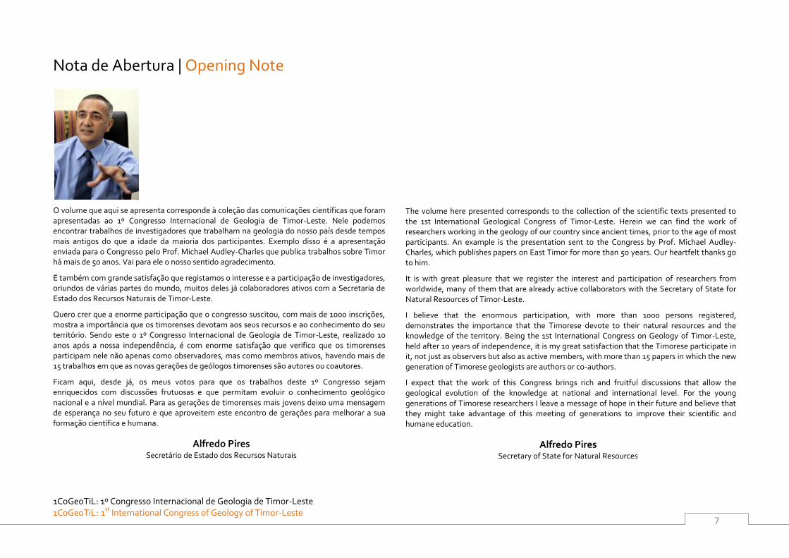
O volume que aqui se apresenta corresponde à coleção das comunicações científicas que foram apresentadas ao 1º Congresso Internacional de Geologia de Timor-Leste. Nele podemos encontrar trabalhos de investigadores que trabalham na geologia do nosso país desde tempos mais antigos do que a idade da maioria dos participantes. Exemplo disso é a apresentação enviada para o Congresso pelo Prof. Michael Audley-Charles que publica trabalhos sobre Timor há mais de 50 anos. Vai para ele o nosso sentido agradecimento.
É também com grande satisfação que registamos o interesse e a participação de investigadores, oriundos de várias partes do mundo, muitos deles já colaboradores ativos com a Secretaria de Estado dos Recursos Naturais de Timor-Leste.
Quero crer que a enorme participação que o congresso suscitou, com mais de 1000 inscrições, mostra a importância que os timorenses devotam aos seus recursos e ao conhecimento do seu território. Sendo este o 1º Congresso Internacional de Geologia de Timor-Leste, realizado 10 anos após a nossa independência, é com enorme satisfação que verifico que os timorenses participam nele não apenas como observadores, mas como membros ativos, havendo mais de 15 trabalhos em que as novas gerações de geólogos timorenses são autores ou coautores.
Ficam aqui, desde já, os meus votos para que os trabalhos deste 1º Congresso sejam enriquecidos com discussões frutuosas e que permitam evoluir o conhecimento geológico nacional e a nível mundial. Para as gerações de timorenses mais jovens deixo uma mensagem de esperança no seu futuro e que aproveitem este encontro de gerações para melhorar a sua formação científica e humana.
Alfredo Pires Secretário de Estado dos Recursos Naturais
The volume here presented corresponds to the collection of the scientific texts presented to the 1st International Geological Congress of Timor-Leste. Herein we can find the work of researchers working in the geology of our country since ancient times, prior to the age of most participants. An example is the presentation sent to the Congress by Prof. Michael Audley-Charles, which publishes papers on East Timor for more than 50 years. Our heartfelt thanks go to him.
It is with great pleasure that we register the interest and participation of researchers from worldwide, many of them that are already active collaborators with the Secretary of State for Natural Resources of Timor-Leste.
I believe that the enormous participation, with more than 1000 persons registered, demonstrates the importance that the Timorese devote to their natural resources and the knowledge of the territory. Being the 1st International Congress on Geology of Timor-Leste, held after 10 years of independence, it is my great satisfaction that the Timorese participate in it, not just as observers but also as active members, with more than 15 papers in which the new generation of Timorese geologists are authors or co-authors.
I expect that the work of this Congress brings rich and fruitful discussions that allow the geological evolution of the knowledge at national and international level. For the young generations of Timorese researchers I leave a message of hope in their future and believe that they might take advantage of this meeting of generations to improve their scientific and humane education.
Alfredo Pires Secretary of State for Natural Resources
1CoGeoTiL: 1º Congresso Internacional de Geologia de Timor-Leste
1CoGeoTiL: 1st International Congress of Geology of Timor-Leste
8
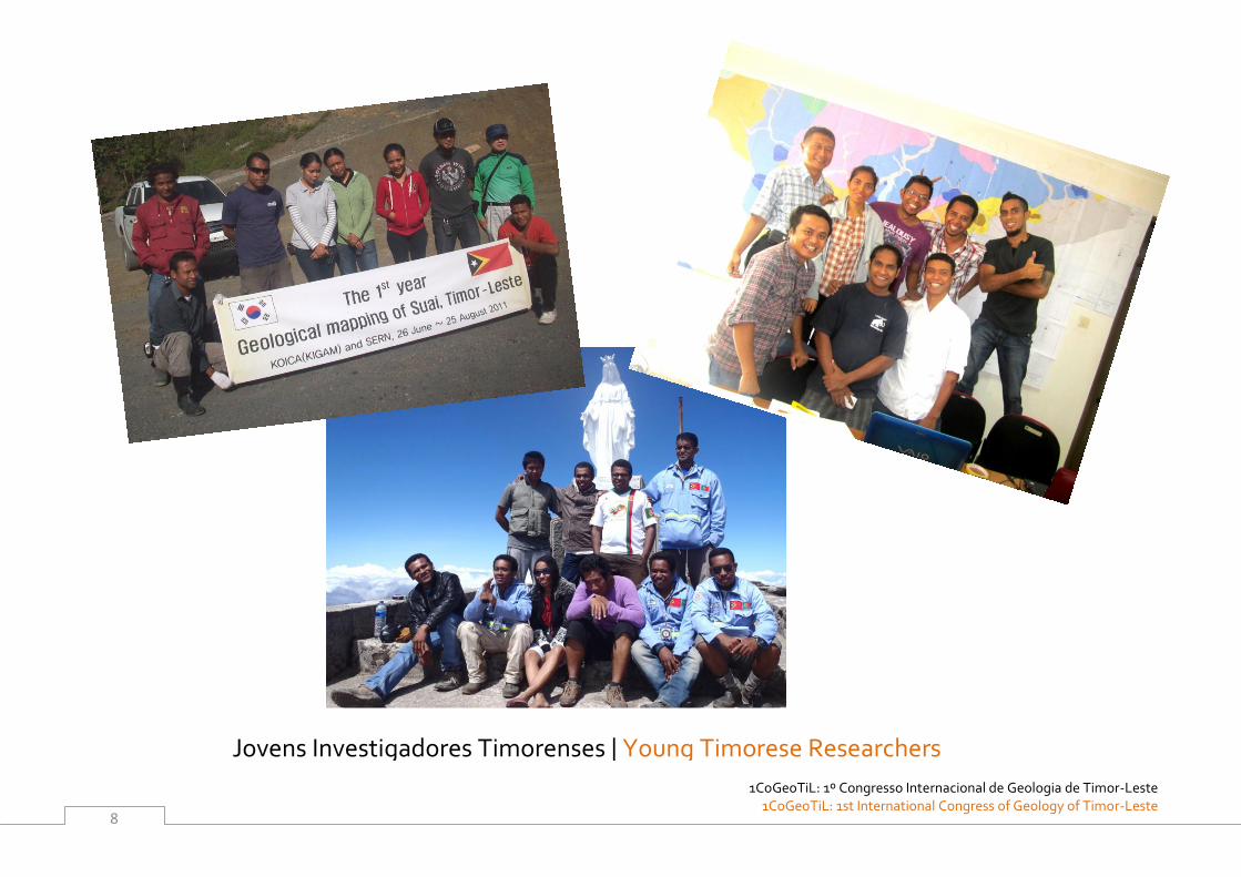
Jovens Investigadores Timorenses | Young Timorese Researchers
1CoGeoTiL: 1º Congresso Internacional de Geologia de Timor-Leste 1CoGeoTiL: 1st
International Congress of Geology of Timor-Leste
9
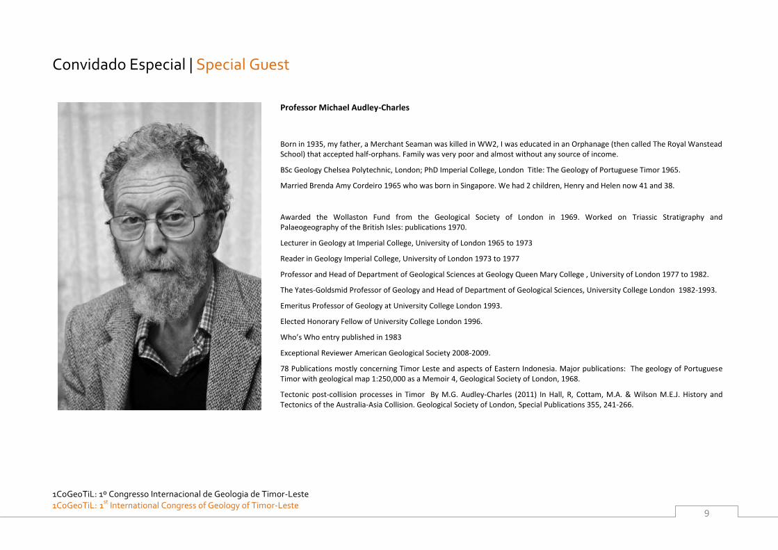
Convidado Especial | Special Guest
Professor Michael Audley-Charles
Born in 1935, my father, a Merchant Seaman was killed in WW2, I was educated in an Orphanage (then called The Royal Wanstead School) that accepted half-orphans. Family was very poor and almost without any source of income.
BSc Geology Chelsea Polytechnic, London; PhD Imperial College, London Title: The Geology of Portuguese Timor 1965.
Married Brenda Amy Cordeiro 1965 who was born in Singapore. We had 2 children, Henry and Helen now 41 and 38.
Awarded the Wollaston Fund from the Geological Society of London in 1969. Worked on Triassic Stratigraphy and Palaeogeography of the British Isles: publications 1970.
Lecturer in Geology at Imperial College, University of London 1965 to 1973
Reader in Geology Imperial College, University of London 1973 to 1977
Professor and Head of Department of Geological Sciences at Geology Queen Mary College , University of London 1977 to 1982.
The Yates-Goldsmid Professor of Geology and Head of Department of Geological Sciences, University College London 1982-1993.
Emeritus Professor of Geology at University College London 1993.
Elected Honorary Fellow of University College London 1996.
Who’s Who entry published in 1983
Exceptional Reviewer American Geological Society 2008-2009.
78 Publications mostly concerning Timor Leste and aspects of Eastern Indonesia. Major publications: The geology of Portuguese Timor with geological map 1:250,000 as a Memoir 4, Geological Society of London, 1968.
Tectonic post-collision processes in Timor By M.G. Audley-Charles (2011) In Hall, R, Cottam, M.A. & Wilson M.E.J. History and Tectonics of the Australia-Asia Collision. Geological Society of London, Special Publications 355, 241-266.
1CoGeoTiL: 1º Congresso Internacional de Geologia de Timor-Leste
1CoGeoTiL: 1st International Congress of Geology of Timor-Leste
10
Oradores convidados | Keynote Speakers
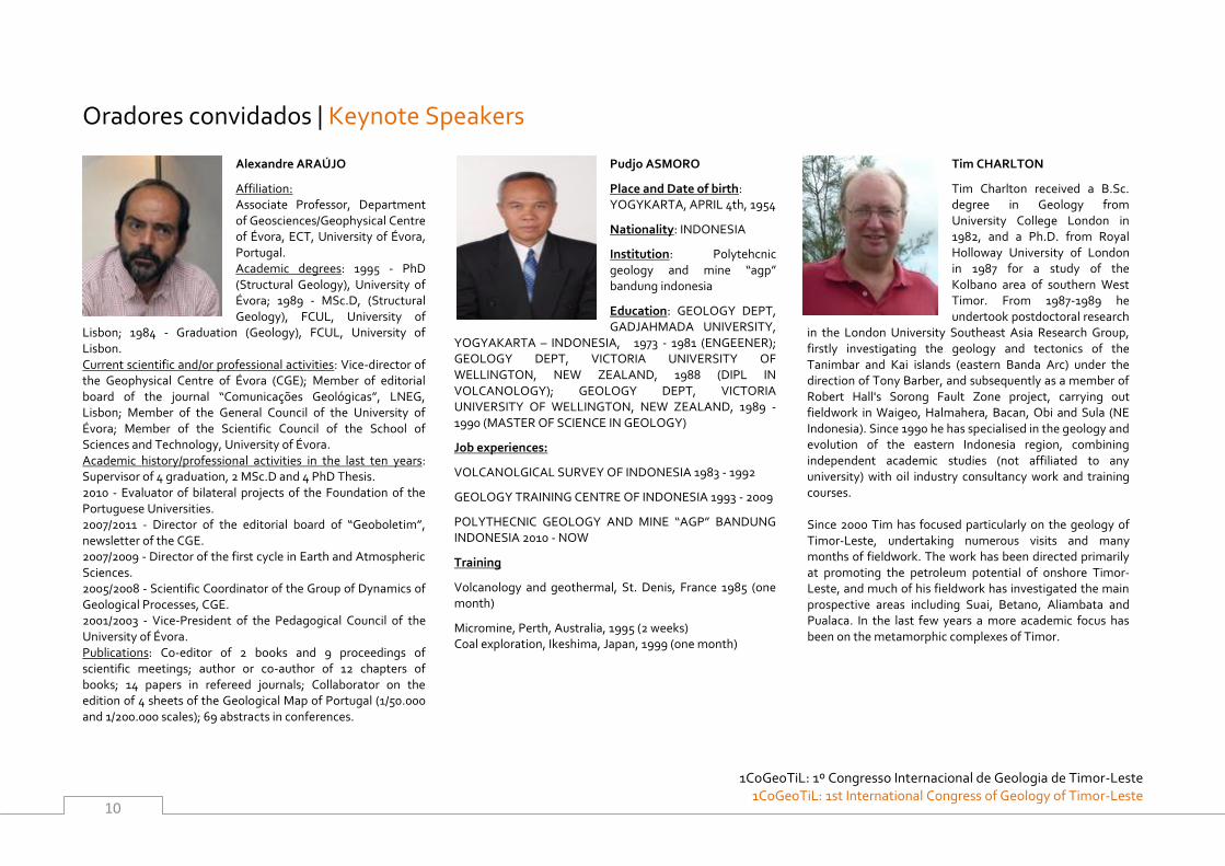
Alexandre ARAÚJO
Affiliation: Associate Professor, Department of Geosciences/Geophysical Centre of Évora, ECT, University of Évora, Portugal. Academic degrees: 1995 - PhD (Structural Geology), University of Évora; 1989 - MSc.D, (Structural Geology), FCUL, University of
Lisbon; 1984 - Graduation (Geology), FCUL, University of Lisbon. Current scientific and/or professional activities: Vice-director of the Geophysical Centre of Évora (CGE); Member of editorial board of the journal “Comunicações Geológicas”, LNEG, Lisbon; Member of the General Council of the University of Évora; Member of the Scientific Council of the School of Sciences and Technology, University of Évora. Academic history/professional activities in the last ten years: Supervisor of 4 graduation, 2 MSc.D and 4 PhD Thesis. 2010 - Evaluator of bilateral projects of the Foundation of the Portuguese Universities. 2007/2011 - Director of the editorial board of “Geoboletim”, newsletter of the CGE. 2007/2009 - Director of the first cycle in Earth and Atmospheric Sciences. 2005/2008 - Scientific Coordinator of the Group of Dynamics of Geological Processes, CGE. 2001/2003 - Vice-President of the Pedagogical Council of the University of Évora. Publications: Co-editor of 2 books and 9 proceedings of scientific meetings; author or co-author of 12 chapters of books; 14 papers in refereed journals; Collaborator on the edition of 4 sheets of the Geological Map of Portugal (1/50.000 and 1/200.000 scales); 69 abstracts in conferences.
Pudjo ASMORO
Place and Date of birth: YOGYKARTA, APRIL 4th, 1954
Nationality: INDONESIA
Institution: Polytehcnic geology and mine “agp” bandung indonesia
Education: GEOLOGY DEPT, GADJAHMADA UNIVERSITY,
YOGYAKARTA – INDONESIA, 1973 - 1981 (ENGEENER); GEOLOGY DEPT, VICTORIA UNIVERSITY OF WELLINGTON, NEW ZEALAND, 1988 (DIPL IN VOLCANOLOGY); GEOLOGY DEPT, VICTORIA UNIVERSITY OF WELLINGTON, NEW ZEALAND, 1989 - 1990 (MASTER OF SCIENCE IN GEOLOGY)
Job experiences:
VOLCANOLGICAL SURVEY OF INDONESIA 1983 - 1992
GEOLOGY TRAINING CENTRE OF INDONESIA 1993 - 2009
POLYTHECNIC GEOLOGY AND MINE “AGP” BANDUNG INDONESIA 2010 - NOW
Training
Volcanology and geothermal, St. Denis, France 1985 (one month)
Micromine, Perth, Australia, 1995 (2 weeks) Coal exploration, Ikeshima, Japan, 1999 (one month)
Tim CHARLTON
Tim Charlton received a B.Sc. degree in Geology from University College London in 1982, and a Ph.D. from Royal Holloway University of London in 1987 for a study of the Kolbano area of southern West Timor. From 1987-1989 he undertook postdoctoral research
in the London University Southeast Asia Research Group, firstly investigating the geology and tectonics of the Tanimbar and Kai islands (eastern Banda Arc) under the direction of Tony Barber, and subsequently as a member of Robert Hall's Sorong Fault Zone project, carrying out fieldwork in Waigeo, Halmahera, Bacan, Obi and Sula (NE Indonesia). Since 1990 he has specialised in the geology and evolution of the eastern Indonesia region, combining independent academic studies (not affiliated to any university) with oil industry consultancy work and training courses. Since 2000 Tim has focused particularly on the geology of Timor-Leste, undertaking numerous visits and many months of fieldwork. The work has been directed primarily at promoting the petroleum potential of onshore Timor-Leste, and much of his fieldwork has investigated the main prospective areas including Suai, Betano, Aliambata and Pualaca. In the last few years a more academic focus has been on the metamorphic complexes of Timor.
1CoGeoTiL: 1º Congresso Internacional de Geologia de Timor-Leste 1CoGeoTiL: 1st
International Congress of Geology of Timor-Leste
11
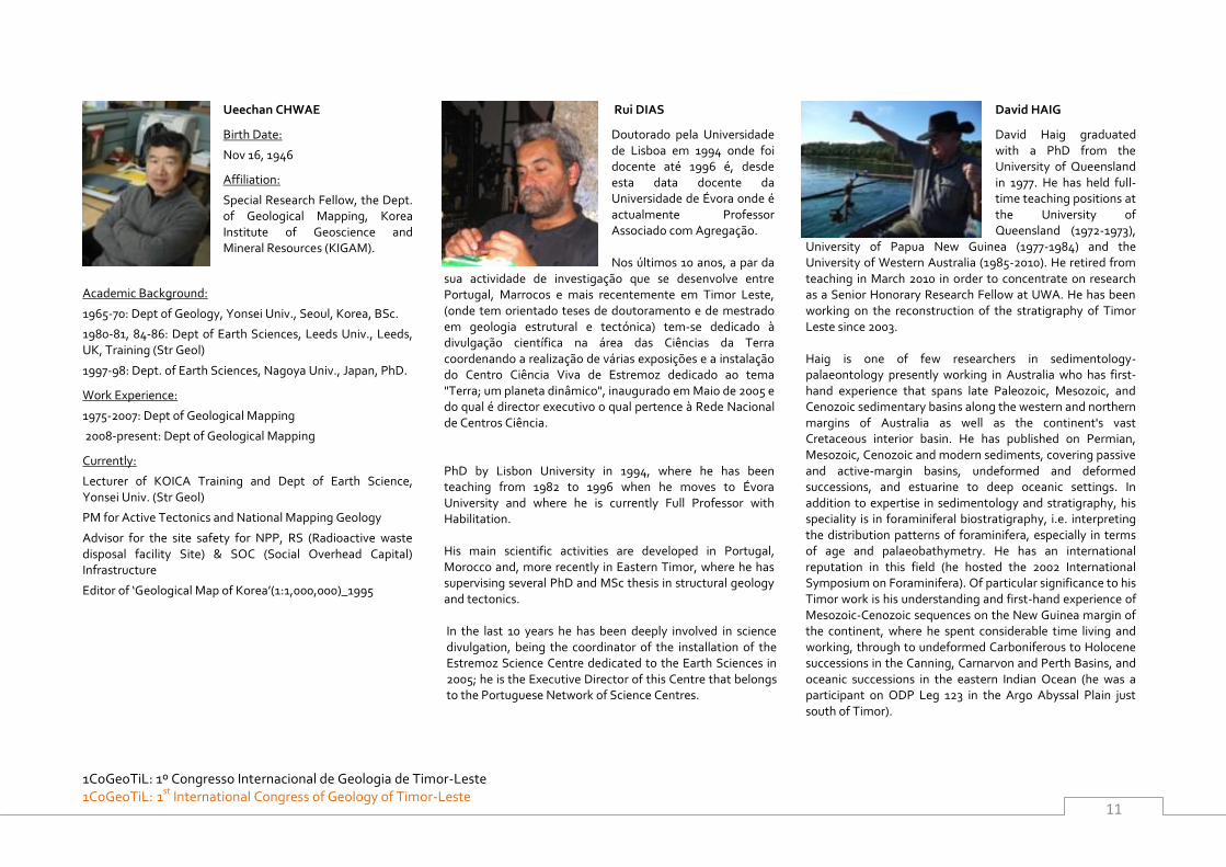
Ueechan CHWAE
Birth Date:
Nov 16, 1946
Affiliation:
Special Research Fellow, the Dept. of Geological Mapping, Korea Institute of Geoscience and Mineral Resources (KIGAM).
Academic Background:
1965-70: Dept of Geology, Yonsei Univ., Seoul, Korea, BSc.
1980-81, 84-86: Dept of Earth Sciences, Leeds Univ., Leeds, UK, Training (Str Geol)
1997-98: Dept. of Earth Sciences, Nagoya Univ., Japan, PhD.
Work Experience:
1975-2007: Dept of Geological Mapping
2008-present: Dept of Geological Mapping
Currently:
Lecturer of KOICA Training and Dept of Earth Science, Yonsei Univ. (Str Geol)
PM for Active Tectonics and National Mapping Geology
Advisor for the site safety for NPP, RS (Radioactive waste disposal facility Site) & SOC (Social Overhead Capital) Infrastructure
Editor of ‘Geological Map of Korea’(1:1,000,000)_1995
Rui DIAS
Doutorado pela Universidade de Lisboa em 1994 onde foi docente até 1996 é, desde esta data docente da Universidade de Évora onde é actualmente Professor Associado com Agregação. Nos últimos 10 anos, a par da
sua actividade de investigação que se desenvolve entre Portugal, Marrocos e mais recentemente em Timor Leste, (onde tem orientado teses de doutoramento e de mestrado em geologia estrutural e tectónica) tem-se dedicado à divulgação científica na área das Ciências da Terra coordenando a realização de várias exposições e a instalação do Centro Ciência Viva de Estremoz dedicado ao tema "Terra; um planeta dinâmico", inaugurado em Maio de 2005 e do qual é director executivo o qual pertence à Rede Nacional de Centros Ciência.
PhD by Lisbon University in 1994, where he has been teaching from 1982 to 1996 when he moves to Évora University and where he is currently Full Professor with Habilitation. His main scientific activities are developed in Portugal, Morocco and, more recently in Eastern Timor, where he has supervising several PhD and MSc thesis in structural geology and tectonics. In the last 10 years he has been deeply involved in science divulgation, being the coordinator of the installation of the Estremoz Science Centre dedicated to the Earth Sciences in 2005; he is the Executive Director of this Centre that belongs to the Portuguese Network of Science Centres.
David HAIG
David Haig graduated with a PhD from the University of Queensland in 1977. He has held full-time teaching positions at the University of Queensland (1972-1973),
University of Papua New Guinea (1977-1984) and the University of Western Australia (1985-2010). He retired from teaching in March 2010 in order to concentrate on research as a Senior Honorary Research Fellow at UWA. He has been working on the reconstruction of the stratigraphy of Timor Leste since 2003. Haig is one of few researchers in sedimentology-palaeontology presently working in Australia who has first-hand experience that spans late Paleozoic, Mesozoic, and Cenozoic sedimentary basins along the western and northern margins of Australia as well as the continent's vast Cretaceous interior basin. He has published on Permian, Mesozoic, Cenozoic and modern sediments, covering passive and active-margin basins, undeformed and deformed successions, and estuarine to deep oceanic settings. In addition to expertise in sedimentology and stratigraphy, his speciality is in foraminiferal biostratigraphy, i.e. interpreting the distribution patterns of foraminifera, especially in terms of age and palaeobathymetry. He has an international reputation in this field (he hosted the 2002 International Symposium on Foraminifera). Of particular significance to his Timor work is his understanding and first-hand experience of Mesozoic-Cenozoic sequences on the New Guinea margin of the continent, where he spent considerable time living and working, through to undeformed Carboniferous to Holocene successions in the Canning, Carnarvon and Perth Basins, and oceanic successions in the eastern Indian Ocean (he was a participant on ODP Leg 123 in the Argo Abyssal Plain just south of Timor).
1CoGeoTiL: 1º Congresso Internacional de Geologia de Timor-Leste
1CoGeoTiL: 1st International Congress of Geology of Timor-Leste
12
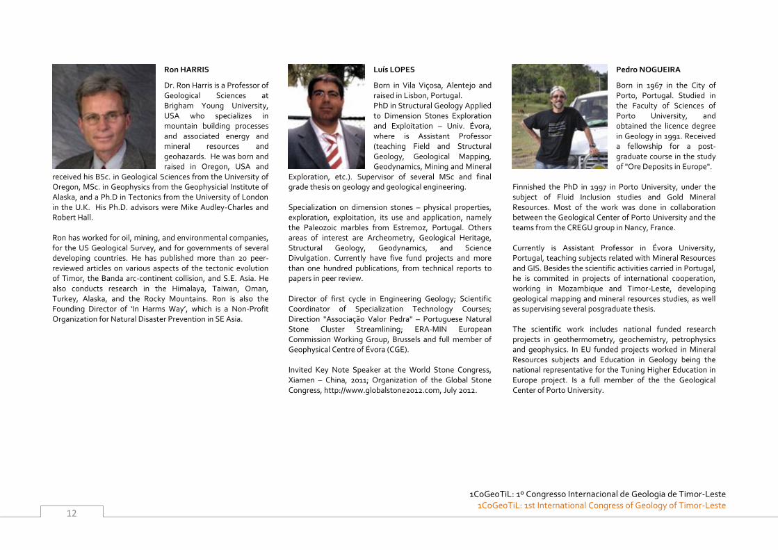
Ron HARRIS
Dr. Ron Harris is a Professor of Geological Sciences at Brigham Young University, USA who specializes in mountain building processes and associated energy and mineral resources and geohazards. He was born and raised in Oregon, USA and
received his BSc. in Geological Sciences from the University of Oregon, MSc. in Geophysics from the Geophysicial Institute of Alaska, and a Ph.D in Tectonics from the University of London in the U.K. His Ph.D. advisors were Mike Audley-Charles and Robert Hall. Ron has worked for oil, mining, and environmental companies, for the US Geological Survey, and for governments of several developing countries. He has published more than 20 peer-reviewed articles on various aspects of the tectonic evolution of Timor, the Banda arc-continent collision, and S.E. Asia. He also conducts research in the Himalaya, Taiwan, Oman, Turkey, Alaska, and the Rocky Mountains. Ron is also the Founding Director of ‘In Harms Way’, which is a Non-Profit Organization for Natural Disaster Prevention in SE Asia.
Luís LOPES
Born in Vila Viçosa, Alentejo and raised in Lisbon, Portugal. PhD in Structural Geology Applied to Dimension Stones Exploration and Exploitation – Univ. Évora, where is Assistant Professor (teaching Field and Structural Geology, Geological Mapping, Geodynamics, Mining and Mineral
Exploration, etc.). Supervisor of several MSc and final grade thesis on geology and geological engineering. Specialization on dimension stones – physical properties, exploration, exploitation, its use and application, namely the Paleozoic marbles from Estremoz, Portugal. Others areas of interest are Archeometry, Geological Heritage, Structural Geology, Geodynamics, and Science Divulgation. Currently have five fund projects and more than one hundred publications, from technical reports to papers in peer review. Director of first cycle in Engineering Geology; Scientific Coordinator of Specialization Technology Courses; Direction "Associação Valor Pedra" – Portuguese Natural Stone Cluster Streamlining; ERA-MIN European Commission Working Group, Brussels and full member of Geophysical Centre of Évora (CGE). Invited Key Note Speaker at the World Stone Congress, Xiamen – China, 2011; Organization of the Global Stone Congress, http://www.globalstone2012.com, July 2012.
Pedro NOGUEIRA
Born in 1967 in the City of Porto, Portugal. Studied in the Faculty of Sciences of Porto University, and obtained the licence degree in Geology in 1991. Received a fellowship for a post-graduate course in the study of "Ore Deposits in Europe".
Finnished the PhD in 1997 in Porto University, under the subject of Fluid Inclusion studies and Gold Mineral Resources. Most of the work was done in collaboration between the Geological Center of Porto University and the teams from the CREGU group in Nancy, France. Currently is Assistant Professor in Évora University, Portugal, teaching subjects related with Mineral Resources and GIS. Besides the scientific activities carried in Portugal, he is commited in projects of international cooperation, working in Mozambique and Timor-Leste, developing geological mapping and mineral resources studies, as well as supervising several posgraduate thesis. The scientific work includes national funded research projects in geothermometry, geochemistry, petrophysics and geophysics. In EU funded projects worked in Mineral Resources subjects and Education in Geology being the national representative for the Tuning Higher Education in Europe project. Is a full member of the the Geological Center of Porto University.
1CoGeoTiL: 1º Congresso Internacional de Geologia de Timor-Leste 1CoGeoTiL: 1st
International Congress of Geology of Timor-Leste
13
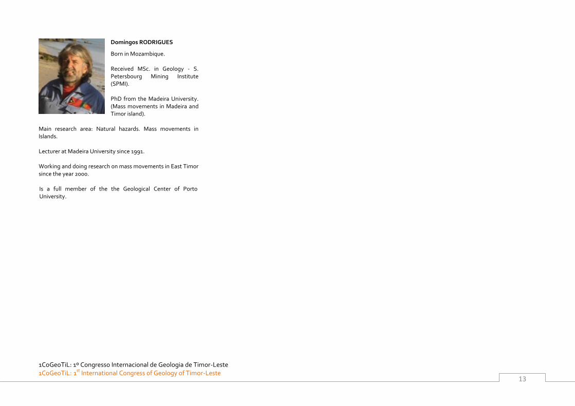
Domingos RODRIGUES
Born in Mozambique. Received MSc. in Geology - S. Petersbourg Mining Institute (SPMI). PhD from the Madeira University. (Mass movements in Madeira and Timor island).
Main research area: Natural hazards. Mass movements in Islands. Lecturer at Madeira University since 1991. Working and doing research on mass movements in East Timor since the year 2000. Is a full member of the the Geological Center of Porto University.

1CoGeoTiL: 1º Congresso Internacional de Geologia de Timor-Leste
1CoGeoTiL: 1st International Congress of Geology of Timor-Leste
14
1CoGeoTiL: 1º Congresso Internacional de Geologia de Timor-Leste 1CoGeoTiL: 1st
International Congress of Geology of Timor-Leste
15
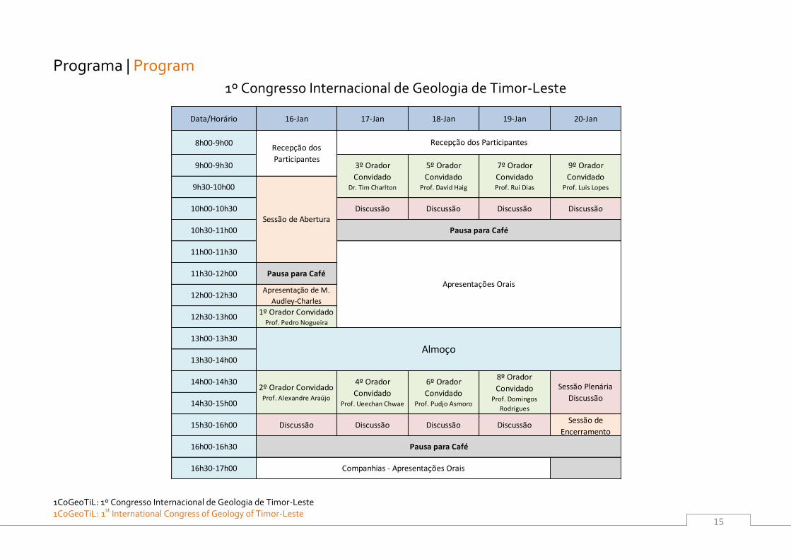
Programa | Program
1º Congresso Internacional de Geologia de Timor-Leste
Data/Horário 16-Jan 17-Jan 18-Jan 19-Jan 20-Jan
8h00-9h00
9h00-9h30
9h30-10h00
10h00-10h30 Discussão Discussão Discussão Discussão
10h30-11h00
11h00-11h30
11h30-12h00 Pausa para Café
12h00-12h30Apresentação de M.
Audley-Charles
12h30-13h001º Orador Convidado
Prof. Pedro Nogueira
13h00-13h30
13h30-14h00
14h00-14h30
14h30-15h00
15h30-16h00 Discussão Discussão Discussão DiscussãoSessão de
Encerramento
16h00-16h30
16h30-17h00
Pausa para Café
Companhias - Apresentações Orais
Almoço
2º Orador ConvidadoProf. Alexandre Araújo
4º Orador
ConvidadoProf. Ueechan Chwae
6º Orador
ConvidadoProf. Pudjo Asmoro
8º Orador
ConvidadoProf. Domingos
Rodrigues
Sessão Plenária
Discussão
Recepção dos
Participantes
Recepção dos Participantes
3º Orador
ConvidadoDr. Tim Charlton
5º Orador
ConvidadoProf. David Haig
7º Orador
ConvidadoProf. Rui Dias
9º Orador
ConvidadoProf. Luis Lopes
Sessão de Abertura
Pausa para Café
Apresentações Orais
1CoGeoTiL: 1º Congresso Internacional de Geologia de Timor-Leste
1CoGeoTiL: 1st International Congress of Geology of Timor-Leste
16
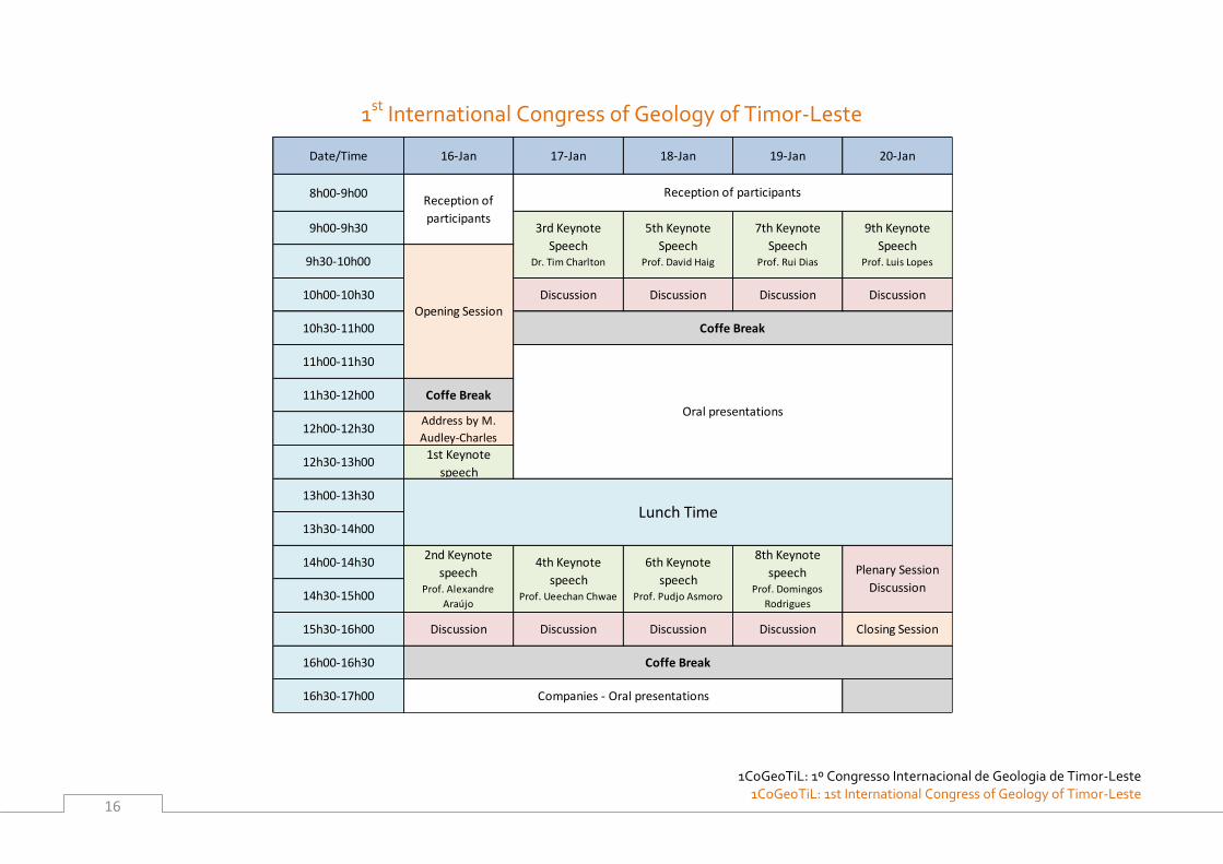
1st International Congress of Geology of Timor-Leste
Date/Time 16-Jan 17-Jan 18-Jan 19-Jan 20-Jan
8h00-9h00
9h00-9h30
9h30-10h00
10h00-10h30 Discussion Discussion Discussion Discussion
10h30-11h00
11h00-11h30
11h30-12h00 Coffe Break
12h00-12h30Address by M.
Audley-Charles
12h30-13h001st Keynote
speech
13h00-13h30
13h30-14h00
14h00-14h30
14h30-15h00
15h30-16h00 Discussion Discussion Discussion Discussion Closing Session
16h00-16h30
16h30-17h00
3rd Keynote
SpeechDr. Tim Charlton
4th Keynote
speechProf. Ueechan Chwae
Companies - Oral presentations
Coffe Break
Reception of
participants
Reception of participants
7th Keynote
SpeechProf. Rui Dias
9th Keynote
SpeechProf. Luis Lopes
8th Keynote
speechProf. Domingos
Rodrigues
Plenary Session
Discussion
5th Keynote
SpeechProf. David Haig
6th Keynote
speechProf. Pudjo Asmoro
Oral presentations
Coffe Break
Opening Session
Lunch Time
2nd Keynote
speechProf. Alexandre
Araújo
Convidado Especial | Apresentação Special Guest | Address
1CoGeoTiL: 1º Congresso Internacional de Geologia de Timor-Leste 1CoGeoTiL: 1st
International Congress of Geology of Timor-Leste
17
Convidado Especial – Apresentação | Special Guest - Address
Convidado Especial | Apresentação Special Guest | Address
1CoGeoTiL: 1º Congresso Internacional de Geologia de Timor-Leste
1CoGeoTiL: 1st International Congress of Geology of Timor-Leste
18
Convidado Especial | Apresentação Special Guest | Address
1CoGeoTiL: 1º Congresso Internacional de Geologia de Timor-Leste 1CoGeoTiL: 1st
International Congress of Geology of Timor-Leste
19
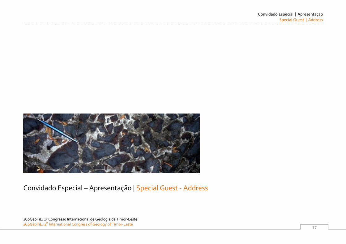
Address to the First International Congress on the Geology of East Timor
BY MICHAEL AUDLEY-CHARLES
Good Morning
High dignitaries (who may be present), the Secretary of State for Natural Resources, and the Rector of the
National University, Geological colleagues and all Members of this First International Geological Congress of
East Timor: It is a very real and proud honour for me to receive the invitation to address this First International
Congress. Had I been well enough to travel I would have attended this important meeting, and it is with deep
regret that I cannot be with you all today in Timor Leste.
Petroleum Exploration: perhaps a new approach
The older stratigraphic mega-sequence of Permian to pre-Late Jurassic age holds all the petroleum source beds
from Lower Permian to pre-Late Jurassic age. Whereas the younger, post-rift mega-sequence, ranging in age
from Late Jurassic to mid-Pliocene, possesses a very different mega-structure from what had been previously
postulated. One thing is certain: the structure of both these mega-sequences was driven and controlled by the
guiding presence of a major decollement, acting with major thrusts that separated the two mega-sequences, as
discrete stratigraphic–structural packages since 4 Ma. A consequence of another tectonic process that drove
northwards the Australian continental crystalline lower crust, forming the Wetar Suture, was that the two
mega-sequences are now two, huge, discretely stacked packages, each with a very different lithology, structure
and deformation style. Another consequence, that applies to the younger mega-sequence, is that these rocks
tend to be flat lying. The implication is that they provide a thick blanket of strata overlying the large and small
open folded structures of the older pre-rift mega-sequence of Lower Permian, Triassic and the sub-Late
Jurassic stratified rocks. This structural package of the two mega-sequences, separated by the great
décollement 1, is also a new concept for Timor (Audley-Charles, 2011, Fig.8). Notice the decollement at the base
of each of the two megasequences, marked by D1 and D2; and at the base of the Australian continental lower
crust where it had detached from the Moho indicated by thick black pecked line. This might merit some
attention from the petroleum exploration industry.
NOTAS | NOTES
_________________________________________
_________________________________________
_________________________________________
_________________________________________
_________________________________________
_________________________________________
_________________________________________
_________________________________________
_________________________________________
_________________________________________
Convidado Especial | Apresentação Special Guest | Address
1CoGeoTiL: 1º Congresso Internacional de Geologia de Timor-Leste
1CoGeoTiL: 1st International Congress of Geology of Timor-Leste
20
otential for nternational arketing of imor’s resource of decorative building stones
Mineral and non-metallic deposits that include building materials are known in Timor Leste and maybe deserve
much more attention. In particular, the many very attractive limestones in Timor Leste, could well provide
abundant and various decorative building stones that might repay quarrying on a large scale. Such rocks are
being exported from India and other Asian countries into Europe, so much so that there is a growing market for
this kind of decorative building stone. Examples of such rocks in Timor Leste include the Permian Maubisse
Limestone, the Triassic Aitutu Limestone, the Cretaceous Borolalo Limestone and the Oligo-Miocene Cablac
Limestone. All or any of these could provide fine, decorative building stones of good quality for selling on the
European and other foreign markets.
My work in Timor
After the terrible recent history of war against the people of Timor Leste, it is a great wonder to see the country
is now rising with remarkable new achievements that must be acknowledged. During those years I often
thought of this country that I knew well, and of the Timorese men who had helped me in my work in the 1959-
1962 period. When I worked in, what was then Portuguese Timor, I learned to speak Tetum fluently. Alas, time
has taken that language from my memory, it was a language that I had enjoyed speaking with my Timorese
team who, as young men in their teens and early twenties, and with an older man who drove the Land Rover,
had worked with me in the field for just over 28 months spread out between 1959 to 1962. They were always
cheerful, always willing to work long hours and were a vital help to me. And they taught me to speak Tetum.
For 13 of those 28 months I worked continually in the field through both monsoons with my loyal and excellent
team of young men and the driver, all of whom made my geological work possible. The names of the members
of my wonderful team of Timorese helpers are recorded in the Acknowledgements of the Memoir of the
Geology of Portuguese Timor published in 1968, and those names are also recorded in my last paper that was
written last year (2011), both were published by the Geological Society of London.
NOTAS | NOTES
_________________________________________
_________________________________________
_________________________________________
_________________________________________
_________________________________________
_________________________________________
_________________________________________
_________________________________________
_________________________________________
_________________________________________
Convidado Especial | Apresentação Special Guest | Address
1CoGeoTiL: 1º Congresso Internacional de Geologia de Timor-Leste 1CoGeoTiL: 1st
International Congress of Geology of Timor-Leste
21
Those 28 months of field studies resulted in the reconnaissance geological map of all Portuguese Timor
(excepting Ocussi), on a scale of 1:250,000 All of the geological work was done on foot. The fossils and
microfossils were all identified by specialists around the world, mostly by the BMR in Australia and NHM in
London, and the microfossils were mostly identified by David Carter at Imperial College, when I became a
research student there late in 1962. Then from 1967 to 1988 I worked in both East and West Timor and in other
Indonesian Islands almost every year, except during two years when I worked in Crete with David Carter and
Robert Hall. I calculate that I have spent at least five full years in the field carrying out geological field studies in
Timor.
avid arter’s important contribution to imor geological studies
David Carter was a marvellous micropalaeontologist, able to work on various taxa as well as his speciality in
foraminifera. He was also an excellent field geologist. In 2008, that was more than 20 years after David Carter
had retired, there was a disgraceful publication in the Journal of Asian Earth Sciences by two geologists who
implied that all the rock samples that David Carter had worked on from the lower slopes of Mt Cablac, in central
East Timor, must have all been wrongly identified by David Carter. These two geologists (and their student)
claimed that, and I quote, “no ablac imestone of shallow marine character, of ate ligocene to arly
Miocene age is present on t ablac.” Fortunately, David Carter’s very carefully curated microfossil-bearing
samples from the lower slopes of Mt Cablac in East Timor were discovered in the Natural History Museum in
London in 2011 by the highly respected micropalaeontologist, Dr. Marcelle K. BouDagher-Fadel, who was then
given access to these samples. She was able to confirm that the foraminiferal analyses made by David Carter on
the shallow marine limestones, called the Cablac Limestone, that had been collected by David Carter himself in
1975 from the lower slopes of Mt Cablac, are definitely Cablac Limestone of late Oligocene to Early Miocene
age. These samples contain the taxa described by David Carter and published in his paper of 1976. Furthermore,
Dr. Marcelle K. BouDagher-Fadel was able to confirm that David Carter’s published identifications of the taxa
and his interpretation of their age reported in his paper of 1976 matched perfectly with his samples preserved in
the Natural History Museum in London. It is now time that the Editor of that Journal acted to correct the
untrue and misleading paper, published in 2008, by asking its authors for an unequivocal
acknowledgement of this gross error to be published now in that Journal. David Carter made a significant
contribution to our knowledge of ast and West imor’s geology. he ablac imestone of late ligocene
to Early Miocene age is clearly exposed in large, extensive outcrops on the generally north-westerly facing,
lower slopes of Mt Cablac above the Wai Luli valley of central East Timor.
NOTAS | NOTES
_________________________________________
_________________________________________
_________________________________________
_________________________________________
_________________________________________
_________________________________________
_________________________________________
_________________________________________
_________________________________________
_________________________________________
Convidado Especial | Apresentação Special Guest | Address
1CoGeoTiL: 1º Congresso Internacional de Geologia de Timor-Leste
1CoGeoTiL: 1st International Congress of Geology of Timor-Leste
22
mportant and key aspects of imor’s geology
Here are eight important discoveries, and related processes of Timor’s geology and tectonics. Some have
implications for the wider Banda region and some beyond. Most of the illustrations are from current work by
Robert Hall and by Audley-Charles.
(1). It is sometimes claimed that the tectonic collision between the Banda Volcanic Forearc and the Australian
continental margin was older than 4 million years. The evidence against this claim is provided by a huge range
of data. One of the key pieces of this evidence is the Tectonic Map reconstructions of the eastern part of the SE
Asian Archipelago, published by Professor Robert Hall (2011, Fig 13). Note the great distance between the
southern edge of the SE Asian continental margin and the northern edge of the Australian continental margin
where futureTimor is located.
This documents and demonstrates the impossibility of any tectonic collision occurring earlier than 4 million
years ago in the Timor region. Furthermore, there is clear evidence from Audley-Charles (2004, Fig. 3). Note
position of Banda Subduction Trench at 5 million years ago, and note position of Australian continental margin
at 5 million years ago; and from Audley-Charles (2011 pp. 250-253). This package of detailed field and
laboratory data militate against any possible tectonic collision of the Banda Forearc with the Australian
continental margin anywhere in the southern part of the Banda Arc before 4 million years. I must point out that
Hall’s detailed tectonic map reconstructions of the distribution of landmasses, islands, seas, oceans, Benioff
Zones and other major faults are based on a long established data base encompassing all of these
physiographic and tectonic features. It is capricious and unreasonable to accept some parts of his reconstructed
maps and not other parts without producing significant data that works for the whole map.
(2). The suggestion that any Australian continental crust has been subducted from Timor cannot possibly be
correct. When this was first pointed out to me by Professor Robert Hall in September 2010 I was taken
completely by surprise. But then I spent some days thinking about what he had said, and I recognised how
wrong I had been in my previous assumptions of this subduction having been possible. This discovery by
Professor Hall is of fundamental importance to the understanding of Timor’s geology and its much wider
context in the Banda Arc. It is now based on the history of the Australian continental lower crust described in (6)
below.
NOTAS | NOTES
_________________________________________
_________________________________________
_________________________________________
_________________________________________
_________________________________________
_________________________________________
_________________________________________
_________________________________________
_________________________________________
_________________________________________
Convidado Especial | Apresentação Special Guest | Address
1CoGeoTiL: 1º Congresso Internacional de Geologia de Timor-Leste 1CoGeoTiL: 1st
International Congress of Geology of Timor-Leste
23
(3). The contention that, the Lolotoi Metamorphic Complex in Timor Leste is part of the Australian continental
crustal basement, and is thus autochthonous, is untenable. The very thorough work carried out by Dr. Harris
and his students on not just the Lolotoi Metamorphic Complex in Timor Leste, but equally on the Mutis
Metamorphic Complex in West Timor, makes it clear that the Lolotoi Metamorphic Complex, like the Mutis
Metamorphic Complex in West Timor, are both allochthonous having a provenance in the Banda forearc
(Audley-Charles, 1981, Fig 3). Note position of Lolotoi Metamorphic Complex and Cablac Limestone in the
Banda Forearc at 3MA in left hand side of Fig. 3. (This is an earlier interpretation by me of the continental
margin collision). Suggestion that this issue is just a matter of semantics is wrong, it is fundamental.
(4). The claim that the Banda Benioff Subduction Trench was located in the Timor Trough is an impossibility.
It has been demonstrated in Figure 7 of my 2011 paper, and in Figure 1 of my 2004 paper that this Benioff
subduction trench has always been north of what is now southern Timor. Note Fig 7 shows the impossibility of
the Timor Trough ever having been filled with ocean crust. A Benioff zone includes the key definition that it
subducts ocean crust. There is no evidence anywhere that ocean crust has been subducted from the Timor
Trough. In fact, if you look at Robert Hall’s tectonic reconstructions (Hall, 2011, Fig 13). Note how Hall shows
that at no time was ocean crust south of Timor. This makes clear that the Banda Benioff subduction could not
possibly have been active at any time in the Timor Trough. The Banda Benioff subduction Trench was
obliterated in the collision of 4Ma, and that Trench has since been filled with thrust slices of the two mega-
sequences (Audley-Charles, 2011, Fig 8) that created the Timor Tectonic Collision Zone from 4million years to
the present day. Furthermore if you look at Hall’s paper (2011, Fig. 13) dealing with tectonic reconstructions of
the Banda Arc region, you will see that no ocean crust has even existed in the Timor Trough that is, and always
was, a part of the Australian continental margin. When there was ocean crust south of the Banda Volcanic
Arc there was no Timor Island (Audley-Charles, 2011, Fig.7) . There was also no Timor Trough, but south of
the Banda Volcanic Arc there was the Banda Benioff Subduction Trench that passed westwards into the
Java Benioff Subduction Trench, both of which lay north ,of what was to become, the Timor Trough (Thus
showing the impossibility of the Timor Trough being filled with ocean crust) (Audley-Charles, 2011, Fig.7 &
8). Note Banda Subduction Trench always located on ocean crust that was overthrust by Australian
Continental Crust during the tectonic collision (Audley-Charles, 2004, Fig 1).
NOTAS | NOTES
_________________________________________
_________________________________________
_________________________________________
_________________________________________
_________________________________________
_________________________________________
_________________________________________
_________________________________________
_________________________________________
_________________________________________
Convidado Especial | Apresentação Special Guest | Address
1CoGeoTiL: 1º Congresso Internacional de Geologia de Timor-Leste
1CoGeoTiL: 1st International Congress of Geology of Timor-Leste
24
The Timor Trough is a part of the Foreland Basin to the Banda Orogen just as the Australian Continental Shelf is
the great Foreland of the Banda Orogen. The Timor Trough sits now and always has sat on Australian
continental crust.
5). The great decollement 1 separates the two mega-sequences into two discrete packages of very different
lithology, very different structure and very different range in age. The younger package of post-rift mega-
sequence is characterised by pressure solution cleavage affecting large scale recumbent folds, thrusts and some
strong to intense imbrication. In great contrast the older pre-rift mega-sequence is characterised by large scale
culminations and depressions up to c. 10 km wave length with limbs often broken , and in thinner bedded
sequences crumpled into smaller folds of 10 m or less in amplitude. It is therefore obvious that these two
sequential mega-sequences have been deformed by the same tectonic collision forces but by very different
processes, reflecting the great differences in their lithology. The mega-sequences are discrete geological
features, which implies that their very different response to the deforming forces was dictated by the
decollement 1 that separated each from the other allowing them to be deformed discretely. The same forces
were also responsible for the creation of the Bobonaro Scaly Clay Melange, partly from the Late Jurassic shales,
partly from the Eocene mudstones and partly from other rocks in post- 4 million years tectonic collision.
6). It is obvious that there must also be a very effective decollement at the base of the Permian Atahoc and
Maubisse formations in order to permit the deformation of the Permian rocks of the pre-rift mega-sequence,
without involving any of the pre-Permian rocks of the Australian continental lower crust below the Permian.
NOTAS | NOTES
_________________________________________
_________________________________________
_________________________________________
_________________________________________
_________________________________________
_________________________________________
_________________________________________
_________________________________________
_________________________________________
_________________________________________
Convidado Especial | Apresentação Special Guest | Address
1CoGeoTiL: 1º Congresso Internacional de Geologia de Timor-Leste 1CoGeoTiL: 1st
International Congress of Geology of Timor-Leste
25
7) We need to consider the roles of these pre-Permian lower crustal rocks at the base of the older, pre-rift,
mega-sequence, which is a decollement at the base of the Permian. Their relations to the Wetar Suture are
identifiable on the BIRPS marine seismic survey being the major south-dipping reflector below the Wetar Strait
(Richardson & Blundell 1996: revised interpretation by Audley-Charles, 2011, Fig 10). The pre-Permian
Australian lower crust must have a hard, crystalline lithology that led it to being thrust by delamination
over the northwards subducting ocean crust in the Banda Arc Benioff zone, thereby preventing the
subduction of any Australian continental crust. This pre-Permian crystalline lower crust was responsible for
uplifting and transporting the Aileu amphibolites from deep below the forearc to the surface, and it was also
responsible for the 50 km of overthrusting of the Banda forearc by the Australian continental crust (Audley-
Charles, 2011, Fig. 3) since 4 million years ago. Note overthrusting of Australian Continental margin over
Forearc by 50 km. And note position of Timor Trough always at least 100 km south of ocean crust.
8). Late orogenic block faulting, with uplift and southward slipping has created a prominent aspect to the
landscape across all Timor, discussed by Audley-Charles (1968 & 2011, p. 261.)
To conclude my Address
I must now end my Address to this First Congress. I want to thank all those who have helped with the
presentation of my address, especially Dr. Pedro Nogueira who has been my guide throughout.
I hope this Congress will encourage high quality geological work in Timor Leste to the benefit of its people.
Timor can give access to fundamental processes of mountain building:- compression, extension,
metamorphism, and access to East Gondwana geology and thus to cratonic basin geology and continental
margin rifting. It can reveal delamination of the lower crust that blocked subduction of any Australian
continental crust. It also reveals the processes that create large scale melange; aspects of diachronism; and
large scale decollements in orogens that are less than 4Ma old.
NOTAS | NOTES
_________________________________________
_________________________________________
_________________________________________
_________________________________________
_________________________________________
_________________________________________
_________________________________________
_________________________________________
_________________________________________
_________________________________________
Convidado Especial | Apresentação Special Guest | Address
1CoGeoTiL: 1º Congresso Internacional de Geologia de Timor-Leste
1CoGeoTiL: 1st International Congress of Geology of Timor-Leste
26
I hope your part of the world will now flourish, prosper and be able to keep all its people safe. With my fond
memories of the people, whom I have long held in respect, and their beautiful land of Timor Leste, I now send
you my best wishes for a highly successful O Primeiro Congresso Internacional sobre a Geologoia de Timor-
Leste.
References
Audley-Charles, M.G. 1981. Geometrical problems and implications of large-scale over-thrusting in the Banda
Arc-Australian margin collision zone. In: Thrust and Nappe Tectonics (edited by McClay, K. & Price, N. Geol.
Soc. Lond. Spec. Publ. 9, 407-416.
Audley-Charles, M. (2004). Ocean trench blocked and obliterated by Banda forearc collision with Australian
proximal continental slope. Tectonophysics 389 (2004) 65–79.
Audley-Charles, M. (2011). Tectonic post-collision processes in Timor. in Hall, R., Cottam, M. A. & Wilson, M. E.
J. (eds) The SE Asian Gateway: History and Tectonics of the Australia–Asia Collision. Geological Society,
London, Special Publications, 355, 241–266.
Hall, R. (2011). Australia–SE Asia collision: plate tectonics and crustal flow. in Hall, R., Cottam, M. A. & Wilson,
M. E. J. (eds) The SE Asian Gateway: History and Tectonics of the Australia–Asia Collision. Geological Society,
London, Special Publications, 355, 75-109.
NOTAS | NOTES
_________________________________________
_________________________________________
_________________________________________
_________________________________________
_________________________________________
_________________________________________
_________________________________________
_________________________________________
_________________________________________
_________________________________________
Oradores Convidados | Resumos Keynote Speakers | Abstracts
1CoGeoTiL: 1º Congresso Internacional de Geologia de Timor-Leste 1CoGeoTiL: 1st
International Congress of Geology of Timor-Leste
27
Oradores convidados - Resumos | Keynote Speakers - Abstracts

Oradores Convidados | Resumos Keynote Speakers | Abstracts
1CoGeoTiL: 1º Congresso Internacional de Geologia de Timor-Leste
1CoGeoTiL: 1st International Congress of Geology of Timor-Leste
28
Oradores Convidados | Resumos Keynote Speakers | Abstracts
1CoGeoTiL: 1º Congresso Internacional de Geologia de Timor-Leste 1CoGeoTiL: 1st
International Congress of Geology of Timor-Leste
29
A importância da cartografia geológica para o desenvolvimento de um Território
A. ALEXANDRE ARAÚJO, P. MADUREIRA
Departamento de Geociências, Centro de Geofísica de Évora, Escola de Ciências e Tecnologia da Universidade de Évora. E-mail: [email protected]; [email protected] Um pouco de História Com a Revolução Industrial iniciada em Inglaterra em meados do século XVIII, a cartografia geológica tornou-se uma necessidade básica das nações em desenvolvimento no sentido de responder a uma crescente procura de recursos minerais metálicos e energéticos. Há uma disputa histórica entre a França e a Inglaterra, sobre quais terão sido os primeiros Serviços Geológicos a nível mundial. A carta geológica de França nasceu em meados do Século XVIII. Jean Ètienne Guettard (1715-1786) realizou um primeiro esboço da carta geológica de França, denominada Mémoire et carte minéralogique sur la nature des terrains qui traversent la France et l'Angleterre. Este trabalho foi publicado nas Mémoires de l'Académie Royale des Sciences em 1746.Segundo alguns historiadores o mais antigo de todos os serviços geológicos seria o de França, que começou rudimentarmente em 1825 visando a Carte Géologique de la France. Os britânicos reivindicam a criação dos primeiros serviços geológicos organizados como tal a nível mundial. Fundado em 1835, o British Geological Survey (BGS) é o centro mais importante referente a informações e expertise sobre as Ciências da Terra no Reino Unido, País onde nasceu a Revolução Industrial. A necessidade de recolha e sistematização de informação sobre os recursos geológicos generaliza-se rapidamente e nos anos seguintes começam a organizar-se as estruturas que deram origem aos Serviços Geológicos da Alemanha (1839), do Canadá (1842), de Portugal (Comissão Geológica, em 1848), da Noruega (1858), dos Estados Unidos da América (1879), da Rússia (1882), da Finlândia (1885), etc. No que se refere a Portugal, as primeiras cartas geológicas, bastante deficientes, complementavam estudos mineiros ou regionais. Em 1841 o geólogo inglês Daniel Sharpe, num estudo intitulado “the geology of neighbourhood of Lisbon”, acompanha este trabalho com a primeira carta dos arredores de Lisboa. Em 1848 José Rebelo de Andrade, apercebendo-se da importância da relação “qualidade dos solos – qualidade do Vinho do Porto”, apresenta no seu estudo do “Distrito vinhateiro do Alto Douro”, um esboço geológico daquela região. A primeira carta geológica de Portugal Continental, cobrindo todo o território, foi publicada em 1876, na escala 1/500.000.
NOTAS | NOTES
_________________________________________
_________________________________________
_________________________________________
_________________________________________
_________________________________________
_________________________________________
_________________________________________
_________________________________________
_________________________________________
_________________________________________
Oradores Convidados| Resumos Keynote Speakers | Abstracts
1CoGeoTiL: 1º Congresso Internacional de Geologia de Timor-Leste
1CoGeoTiL: 1st International Congress of Geology of Timor-Leste
30
Simultaneamente vão surgindo Serviços Geológicos em colónias ultramarinas, em particular inglesas (Índia em 1851, nas províncias australianas de Victoria em 1852, em Queensland, 1868, na Nova Gália do Sul, 1875, na Austrália do Sul, 1882, na Tasmânia, 1883 e na Austrália Ocidental, 1888). Quanto a Timor Leste, parece que o primeiro geólogo que esteve nesta colónia portuguesa foi o suíço H. Hirschi, em 1904. Dispondo de pouco tempo, realizou apenas duas travessias da ilha, identificando largas regiões com formações de idades pérmica, triásica e jurássica. Durante o século XX a Geologia de Timor foi sendo pouco a pouco conhecida, principalmente com base em trabalhos de prospecção petrolífera, sendo de assinalar os estudos realizados pela Timor Oil Company. Os traços gerais da Geologia de Timor-Leste foram estabelecidos com base em trabalhos de campo realizados nas décadas de 50 e 60, merecendo referência particular os trabalhos de síntese de Audley-Charles (1968) e de Azeredo Leme (1968). Após a ocupação por parte da Indonésia (1975) e até à independência (2002), foram principalmente realizados trabalhos de gabinete e laboratório que reinterpretam os estudos anteriores. Só recentemente foi possível voltar a efectuar-se trabalho de campo com segurança. O que é uma Carta Geológica? Uma carta ou mapa geológico é um documento científico e técnico onde se sintetiza, sobre um fundo topográfico adequado, informação relativa aos materiais rochosos que ocorrem na região abrangida pela carta e aos fenómenos geológicos que afectaram esses materiais. Trata-se de uma representação numa superfície plana, da geologia de superfície, incluindo por vezes dados de subsuperfície ou subsolo. A informação contida numa carta geológica inclui a natureza e a distribuição das diferentes rochas à superfície e em profundidade, a posição, forma e idade dessas formações geológicas, a sua geometria e deformação resultante da tectónica, a ocorrência de mineralizações, localização de poços, nascentes naturais, sondagens, pedreiras, jazidas fossilíferas, estações arqueológicas. Toda esta informação é traduzida por cores e símbolos que aparecem na legenda da carta e resultam de uma síntese dos resultados de estudos de campo, investigação laboratorial (análises químicas, petrográficas, paleontológicas), observação de fotografias aéreas e/ou de satélite e de consulta bibliográfica. Algumas cartas mais recentes incluem colunas estratigráficas e cortes geológicos destinados a facilitar a sua leitura e geralmente são acompanhadas por uma notícia explicativa onde se fornece informação complementar que a carta não permite suportar. Muitas vezes é útil recorrer a cartas temáticas mais específicas e, além da carta geológica geral, uma determinada região pode também estar coberta por uma carta hidrogeológica, geotécnica, mineira, tectónica, geoquímica, pedológica, geomagnética, radiométrica, gravimétrica, etc.
NOTAS | NOTES
_________________________________________
_________________________________________
_________________________________________
_________________________________________
_________________________________________
_________________________________________
_________________________________________
_________________________________________
_________________________________________
_________________________________________
Oradores Convidados | Resumos Keynote Speakers | Abstracts
1CoGeoTiL: 1º Congresso Internacional de Geologia de Timor-Leste 1CoGeoTiL: 1st
International Congress of Geology of Timor-Leste
31
Como se faz uma carta geológica? O termo levantamento geológico designa genericamente as actividades e operações de cartografia geológica incluindo por vezes levantamentos geofísicos, geoquímicos, hidrogeológicos, necessários à construção de uma carta geológica. O objectivo básico é estabelecer a natureza, a forma tridimensional, a posição espacial, a origem, a idade, a evolução, e a importância regional ou global dos corpos rochosos presentes na área a cartografar. Os mapas geológicos resultantes de um levantamento geológico podem ser construídos em várias escalas e serem mais ou menos temáticos, em função da geologia e do tipo de interesse colocado na região em estudo. A metodologia e os meios usados num levantamento podem variar muito em função da escala e dos objectivos a atingir mas a cartografia de base de um país pode ser feita sem necessidade de equipamentos ou meios muito sofisticados. Para a produção de mapas geológicos são necessários:
1. Viaturas todo-o-terreno e equipamento portátil para trabalho de campo (GPS, martelos, bússolas, lupas, material de escrita);
2. Cartas topográficas, de preferência em várias escalas, levantadas por topografia convencional e/ou por técnicas de detecção remota;
3. Laboratórios e gabinetes que permitam a realização de estudos complementares e a transposição regular dos dados colhidos no campo para cartas e bases de dados em formato digital. Em termos de equipamento laboratorial, é necessário dispor de computadores, de lupas binoculares, de meios para a preparação de lâminas delgadas e de microscópios petrográficos para o estudo dessas lâminas (mineralógicos, petrográficos, petrológicos, sedimentológicos, micropaleontológicos, etc.). Outro tipo de estudos, envolvendo por exemplo análises geoquímicas pode, numa primeira fase, não justificar o investimento e ser encomendado a laboratórios internacionais.
4. Geólogos devidamente treinados. A cartografia geológica implica uma abordagem holística e portanto um domínio de disciplinas da Geologia como a petrografia, petrologia, paleontologia, estratigrafia, geologia estrutural, geomorfologia, foto-interpretação, sedimentologia, geofísica, pedologia, geoquímica, metalogenia, geocronologia, etc.
NOTAS | NOTES
_________________________________________
_________________________________________
_________________________________________
_________________________________________
_________________________________________
_________________________________________
_________________________________________
_________________________________________
_________________________________________
_________________________________________
Oradores Convidados| Resumos Keynote Speakers | Abstracts
1CoGeoTiL: 1º Congresso Internacional de Geologia de Timor-Leste
1CoGeoTiL: 1st International Congress of Geology of Timor-Leste
32
Para que servem as Cartas Geológicas? A cartografia geológica permite obter o conhecimento racional dos bens minerais e a sua importância em termos de riqueza para um país, pois directa ou indirectamente tudo o que se consome tem a sua origem ou depende de derivados de produtos minerais. Do que se come, passando pelo uso de produtos de higiene e limpeza, aos materiais de construção e até aos utensílios de uma casa, dos aparelhos eléctricos mais simples aos equipamentos electrónicos, quase tudo tem na origem produtos minerais. As cartas geológicas, mostrando-nos a composição e estrutura do subsolo, são documentos fundamentais para: Prospecção e exploração de jazigos minerais metálicos e de matérias primas não metálicas (areia, argila, brita, rochas ornamentais, etc.); Prospecção e exploração de fontes de energia (petróleo, gás natural, carvão, energia geotérmica); Planeamento e escolha de locais mais apropriados para a implantação de grandes obras de engenharia (portos, aeroportos, pontes, barragens, etc.); Prospecção, exploração e abastecimento de águas às populações; Planeamento de áreas agrícolas e uso de minerais como fertilizantes ou correctivos de solos; Planeamento da ocupação do solo, preservação do ambiente; Prevenção de catástrofes naturais (cheias, deslizamentos de massa, sismos); As cartas geológicas são, portanto, documentos indispensáveis a um bom planeamento, ordenamento e gestão do território. Que estratégia para Timor Leste? Um conhecimento fragmentado, incompleto dos recursos geológicos de um País, suportado apenas por mapas de pequena escala ou por relatórios pontuais de empresas extractivas que actuaram no passado em áreas restritas do território, representa uma forte debilidade para uma nação independente. Os levantamentos geológicos de base, dadas as suas múltiplas aplicações, devem cobrir todo o território e ser abrangentes nos vários domínios da Geologia e mesmo das ciências naturais em geral. Uma boa cartografia geológica pode inclusivamente ser uma importante ferramenta mesmo na área das políticas sociais.
NOTAS | NOTES
_________________________________________
_________________________________________
_________________________________________
_________________________________________
_________________________________________
_________________________________________
_________________________________________
_________________________________________
_________________________________________
_________________________________________
Oradores Convidados | Resumos Keynote Speakers | Abstracts
1CoGeoTiL: 1º Congresso Internacional de Geologia de Timor-Leste 1CoGeoTiL: 1st
International Congress of Geology of Timor-Leste
33
A cartografia geológica de base de um País representa um investimento relativamente elevado e não tem um retorno directo imediato. Esta é uma tarefa que tem que ser executada pelo Estado. As investigações técnico-científicas referentes ao conhecimento geológico do planeta, na maioria dos países adiantados e emergentes, têm sido executadas, de modo programado e sistemático pelos estados, através dos seus serviços geológicos. Historicamente, estas instituições governamentais têm desempenhado o papel de recolha, análise, armazenamento e divulgação da informação geológica. A diminuição dos riscos nos investimentos em exploração mineral é função directa do nível de informação geológica de uma dada região. Assim, um Estado que conhece bem a Geologia do seu território está em boas condições para negociar concessões de prospecção ou exploração com qualquer indústria extractiva, retirando daí vantagens económicas. Este deve ser o caminho que Timor-Leste deve seguir. A Cartografia Geológica existente à escala 1/500.000 tem algumas incorrecções mas é sem dúvida um excelente ponto de partida para a planificação de um programa de Cartografia Geológica à escala 1/50.000, que venha a cobrir todo o território. Apesar de implicar meios muito mais dispendiosos e sofisticados, em países costeiros como é o caso de Timor, a cartografia geológica e geofísica deve ser também estendida ao domínio imerso de modo a permitir averiguar sobre a possibilidade de extensão da plataforma continental ao abrigo do artigo 76º da convenção das Nações Unidas sobre o direito do mar. De igual modo, a cartografia da plataforma continental imersa permite identificar a ocorrência de depósitos minerais que podem vir a afirmar-se como um importante recurso natural. No caso de Timor Leste, não serão apenas os hidrocarbonetos, mas também os agregados siliciclásticos e as areias carbonatadas, bem como a existência de um ambiente geodinâmico favorável à ocorrência de depósitos de sulfuretos maciços (cobre, zinco e ouro) já largamente identificados noutras áreas marginais do Pacífico Sul. Bibliografia (ver versão em inglês)
NOTAS | NOTES
_________________________________________
_________________________________________
_________________________________________
_________________________________________
_________________________________________
_________________________________________
_________________________________________
_________________________________________
_________________________________________
_________________________________________
Oradores Convidados| Resumos Keynote Speakers | Abstracts
1CoGeoTiL: 1º Congresso Internacional de Geologia de Timor-Leste
1CoGeoTiL: 1st International Congress of Geology of Timor-Leste
34
The importance of geological mapping for the development of a Country
A. ALEXANDRE ARAÚJO, P. MADUREIRA Departamento de Geociências, Centro de Geofísica de Évora, Escola de Ciências e Tecnologia da Universidade de Évora. E-mail: [email protected]; [email protected] A piece of history From the Industrial Revolution, began in England in the mid-eighteenth century, the geological mapping has become a basic necessity of the developing nations in order to meet a growing demand for the metallic minerals and energy resources. There is a historical dispute between France and England, about which belong the first Geological Surveys in the world. The geological map of France was born in the mid-eighteenth century. Guettard, Jean Etienne (1715-1786) carried out a first sketch of the geological map of France, called «Mémoire et carte minéralogique sur la nature des terrains qui traversent la France et l'Angleterre ». This work was published on the Mémoires de l'Académie Royale des Sciences in 1746. According to some historians the oldest of all geological surveys should be the French ones, which rudimentary began in 1825 with the aim of preparing the Carte Géologique de la France. The British people claim for the establishment of the first geological surveys worldwide, organized to that purpose. Founded in 1835, the British Geological Survey (BGS) is the most important center concerning information and expertise of the Earth Sciences in the United Kingdom, country where the Industrial Revolution was born. The need of the nations on collecting and systematizing information about geological resources quickly generalizes worldwide and thereafter begin to organize structures which create the Geological Survey of Germany (1839), Canada (1842), Portugal (Comissão Geológica, in 1848), Norway (1858), United States of America (1879), Russia (1882), Finland (1885). In what concerns Portugal, the first geological maps, generally quite poor, resulted from mining and regional studies. In 1841 the English geologist Daniel Sharpe, in a study entitled "Geology of the neighborhood of Lisbon," presents the first map of the surrounding region of this city. In 1848 José Rebelo de Andrade, realizing the importance of the relationship "soil quality - quality of Port wine," presents a geological sketch in his study "District of the Upper Douro Vineyard". The first geological map of Portugal, covering the entire territory, was published in 1876, on the scale 1/500.000.
NOTAS | NOTES
_________________________________________
_________________________________________
_________________________________________
_________________________________________
_________________________________________
_________________________________________
_________________________________________
_________________________________________
_________________________________________
_________________________________________
Oradores Convidados | Resumos Keynote Speakers | Abstracts
1CoGeoTiL: 1º Congresso Internacional de Geologia de Timor-Leste 1CoGeoTiL: 1st
International Congress of Geology of Timor-Leste
35
Simultaneously arise in the colonies Geological Surveys, in particular in the British colonies (India in 1851, the Australian provinces of Victoria in 1852, Queensland, 1868, in New South Gaul, 1875, in South Australia, 1882, Tasmania, 1883 and Western Australia, 1888). With regard to East Timor, it seems that H. Hirsch, from Switzerland, was the first geologist being in this Portuguese colony, in 1904. Without much time to work, H. Hirsch only made two crossings on the island, identifying large regions with formations of Permian, Triassic and Jurassic age. During the twentieth century the geology of Timor was progressively known, mainly based on oil prospecting work. The studies conducted by Timor Oil Company were particularly relevant. The general features of the geology of East Timor were established based on the field work conducted in the years 50 and 60. It deserves particular mention the works conducted by Audley-Charles (1968) and Azeredo Leme (1968). After the occupation by Indonesia (1975) and until independence (2002), the work done was mainly re-interpretations, in office and laboratory, of data published in previous works. Only recently it was possible to carry out field work in relative safety. What is a Geological map? A geologic map or chart is a scientific and technical document which summarizes, on a suitable topographic background, information on rock materials occurring in the region covered by the map and the geological phenomena affecting these materials. It is a bi dimensional representation of the outcrops geology on a plan surface, including sometimes, subsurface data. In a geological map the information includes the nature and distribution of different rocks at surface and at depth, position, shape and age of these formations and their geometry resulting from tectonic deformation, the occurrence of mineralization, location of wells, natural springs, quarries, fossiliferous deposits, archaeological sites. All this information is represented by colors and symbols that appear in the legend of the map and represents a synthesis of the results of field studies, laboratory investigations (chemical, petrographic, paleontological), observation of aerial photographs and/or satellite images and bibliographic research. Some recent maps include stratigraphic columns and geological sections in order to facilitate the reading and they are usually accompanied by an explanatory report with additional information not included on the map. It is often useful to use more specific thematic maps, so in addition to the general geological map, a particular region may also be covered by thematic maps, such as hydrogeological, geotechnical, mining, tectonic, geochemical, pedological, geomagnetic, radiometric, gravity.
NOTAS | NOTES
_________________________________________
_________________________________________
_________________________________________
_________________________________________
_________________________________________
_________________________________________
_________________________________________
_________________________________________
_________________________________________
_________________________________________
Oradores Convidados| Resumos Keynote Speakers | Abstracts
1CoGeoTiL: 1º Congresso Internacional de Geologia de Timor-Leste
1CoGeoTiL: 1st International Congress of Geology of Timor-Leste
36
How to make a geological map? The field work related to geological mapping, includes sometimes geophysical, geochemical and hydrogeological studies, necessary to construct a geological map. The basic objective is to establish the nature, three-dimensional form, position in space, genesis, age, evolution, and regional or global importance of the rocky bodies in the mapped area. Geologic maps can be constructed on various scales and they are more or less thematic, depending on the geology and the type of interest on the region under study. The methodology and facilities used in the preparation of a map can greatly vary, depending on the scale and the objectives to be achieved but the basic geological maps of a country can be done without to much sophisticated equipment. For the production of geological maps we need:
1. Four-wheel-drive vehicles and portable equipment for field work (GPS, hammers, compasses, magnifying glasses, writing materials);
2. Topographical maps, preferably at various scales, made by conventional methods and/or remote sensing techniques;
3. Laboratories and offices properly prepared for complementary studies and for making the regular transposition of the data collected in the field to maps and databases in digital format. In what concerns laboratory equipment, it is necessary to have computers, binocular loupes, equipment for the preparation of thin sections and petrographic microscopes for the study of the thin sections (mineralogical, petrographic, petrological, sedimentological, micropalaeontological, studies). Other studies as geochemical analysis, don’t justify the investment and they can be ordered at international laboratories.
4. Trained Geologists. The geological mapping involves a holistic approach and therefore a knowledge of many disciplines of geology, such as petrography, petrology, paleontology, stratigraphy, structural geology, geomorphology, photo interpretation, sedimentology, geophysics, pedology, geochemistry, metalogenetic process, geochronology.
NOTAS | NOTES
_________________________________________
_________________________________________
_________________________________________
_________________________________________
_________________________________________
_________________________________________
_________________________________________
_________________________________________
_________________________________________
_________________________________________
Oradores Convidados | Resumos Keynote Speakers | Abstracts
1CoGeoTiL: 1º Congresso Internacional de Geologia de Timor-Leste 1CoGeoTiL: 1st
International Congress of Geology of Timor-Leste
37
What is the utility of a geological map? The geological mapping allows for the rational knowledge of minerals and their importance in terms of the wealth of a country. Almost all the features that we usually consume have a direct or indirect origin in products derived from minerals. From what we eat, to the use of cleaning or hygiene products, and also building materials, and home tools, or from a simplest electrical machine to an electronic equipment, almost everything have mineral products as their source. The geological maps, showing us the composition and structure of the subsoil, are key documents to: Exploration and exploitation of deposits of metallic minerals and non-metallic raw materials (sand, clay, gravel, ornamental rocks); Exploration and exploitation of energy sources (oil, natural gas, coal, geothermal); Planning and choosing appropriate locations for the implementation of large engineering projects (ports, airports, bridges, dams); Prospecting, exploration and water supply to population; Planning of agricultural areas and use of minerals as fertilizers or soil improvers; Planning of land use, environmental preservation; Prevention of natural hazards (floods, landslides, earthquakes); The geological maps are, therefore, essential documents to good planning and territorial management. What strategy for East Timor? A fragmented and incomplete knowledge of the geological resources of the country, only supported by small-scale maps or occasional reports from extractive companies operating in the past in restricted areas of the territory, represents a strong weakness for an independent nation. The basic geological mapping, given its multiple applications, should cover the entire territory and should be comprehensive in the various fields of geology and even in the domain of natural sciences in general. A good geological mapping can even be an important tool in the area of social policy. The basic geological mapping of a country represents a relatively high investment and has no direct immediate return. This is a task that must be carried out by the government. The technical and scientific investigations related to the geological knowledge of the planet, in the most advanced and emerging countries, have been implemented and planned in a systematic way, by the governments, through their geological surveys. Historically, these governmental institutions have played the role of collection, storage and dissemination of geological information.
NOTAS | NOTES
_________________________________________
_________________________________________
_________________________________________
_________________________________________
_________________________________________
_________________________________________
_________________________________________
_________________________________________
_________________________________________
_________________________________________
Oradores Convidados| Resumos Keynote Speakers | Abstracts
1CoGeoTiL: 1º Congresso Internacional de Geologia de Timor-Leste
1CoGeoTiL: 1st International Congress of Geology of Timor-Leste
38
The reduction of the risk on the investments in mineral exploration is a direct function of the level of geological information from a given region. So, a government who knows the geology of its territory has the expertise to negotiate concessions for exploration or exploitation of any extractive industry, with economic advantages. This must be the way that East Timor should follow. The existing geological maps at 1/500.000 scale, have some errors but they are certainly an excellent starting point for planning a program for a geological mapping at 1/50.000 scale, which should cover the entire territory. Although the necessity of much more expensive and sophisticated resources, in coastal countries such as Timor, the geological mapping and geophysical surveys should also be extended to the immersed domain to ascertain the possible extension of the continental shelf following the article 76 of the United Nations Convention on the Law of the Sea. Similarly, the mapping of the immersed continental shelf can identify the occurrence of mineral deposits that may assert itself as an important natural resource. In the case of East Timor, not only the oil and gas, but also siliciclastic aggregates and lime, as well as the existence of a geodynamic conditions favorable to the occurrence of massive sulphide deposits (copper, zinc and gold) already widely identified in other marginal areas in the South Pacific Ocean. References
Audley-Charles, M. G., 1968. The Geology of Portuguese Timor. Mem. Geol. Soc. London 4, 1–76.
Ladeira, E., 2009. PRODUTO 04 ANÁLISE DA INFORMAÇÃO GEOLÓGICA DO BRASIL, Relatório Técnico 10 Informação Geológica do Brasil, PROJETO DE ASSISTÊNCIA TÉCNICA AO SETOR DE ENERGIA, 110 pp.
Leme, A., 1968. Breve ensaio sobre a geologia da província de Timor. Curso sobre a geologia do ultramar. Junta de Investigações do Ultramar. Volume 1, pp. 106-161.
Nogueira, P., 2010. Geologia de Timor-Leste: Uma breve introdução histórico-bibliográfica, X Congresso Geoquímica dos Países de Língua Portuguesa/XVI Semana Geoquímica, Departamento de Geologia, Faculdade de Ciências da Universidade do Porto 8 pp.
Rebelo, J. A., 1999. As Cartas Geológicas ao serviço do desenvolvimento. Publicação integrada nas Comemorações dos 150 anos da criação da I Comissão Geológica, Instituto Geológico e Mineiro, 56 pp.
NOTAS | NOTES
_________________________________________
_________________________________________
_________________________________________
_________________________________________
_________________________________________
_________________________________________
_________________________________________
_________________________________________
_________________________________________
_________________________________________

Oradores Convidados | Resumos Keynote Speakers | Abstracts
1CoGeoTiL: 1º Congresso Internacional de Geologia de Timor-Leste 1CoGeoTiL: 1st
International Congress of Geology of Timor-Leste
39
The stratigraphy of Covalima
PUDJO ASMORO 1, NORBERTA SOARES DA COSTA
2, OCTÁVIO JORDÃO DE ARAUJO 2, JOSÉ MANUEL DE SÁ
SOARES, FREDERICO CARLOS DOS SANTOS 2, CECILIA FREITAS
2, ANTÓNIO DE ARAÚJO 2, RICARDO DA
CONCEICAO VERDIAL 2
1. Polythechnic Geology and Mine “AGP”, Bandung Indonesia 2. Directorate For Geology & Mineral Resources, Secretary of State For Natural Resources, Timor Leste The geology of Covalima area is very complex, it is believed that the area might formed by subduction during Middle Miocene which lead to melange “process” in few places. The area is composed by Pre-Tertiary up to Holocene metamorphic and sedimentary rock units. In metamorphic units some volcanic components are also influencing its formation such as volcanic sandstone, basalt and basaltic andesite. The assemblage of micro-organism in Pre-Pliocene sedimentary rocks is rarely appeared but was very abundant during Pliocene-Pleistocene. Based on their lithological characteristics, paleontology analysis and the observation on the field stratigraphic position, the rock units of the Covalima are divided into 18 lithostratigraphic units as the following: Metasandstone, Crinoid limestone, Massive limestone, Calcareous siltstone, Calcilutite calcareous sandstone, Micaceous sandstone, Melange, Cherty limestone, Limestone breccia, Calcareous sandstone, Calcareous pebble conglometate, White calcareous sandstone, Reef limestone, Calcareous claystone, Calcareous gravel conglomerate, Clayey Sandstone, Cobble conglomerate units and Alluvium deposit.
1. Metasandstone unit: Consists of low to high grade methamorphic volcanic sandstone, including phyllites, schists and quarzite, andesite and andesitic basalt.
2. Crinoids Limestone unit: Consists of reddish brown limestone, grain supported, dense, hard, compacted, crystalline, calcareous, abundant of crinoids, ammonite fossils, oolite and fossil shells with irregular or elongated shapes.
3. Massive limestone unit: Consists of white, light grey and brownish, generally crystalline, hard, fine grained, massive and marblely.
4. Calcareous siltstone unit: Mostly composed by greyish thin bedded calcareous siltstone and claystone, intercalated by reddish layers of sandstone.
5. Calcilutite calcareous sandstone unit: Generally composed by light grey calcilutite and calcareous sandstone, moderately hard, dense, fine to moderate sand size, bedded, imbricated, some layers abundant in bioturbations and Halobia tracks.
NOTAS | NOTES
_________________________________________
_________________________________________
_________________________________________
_________________________________________
_________________________________________
_________________________________________
_________________________________________
_________________________________________
_________________________________________
_________________________________________
Oradores Convidados| Resumos Keynote Speakers | Abstracts
1CoGeoTiL: 1º Congresso Internacional de Geologia de Timor-Leste
1CoGeoTiL: 1st International Congress of Geology of Timor-Leste
40
6. Micaceous sandstone unit: Composed by grayish brown sandstone, fine to coarse grain interbedded with silt and clay layers, soft to hard, mostly noncalcareous and micaceous.
7. Melange unit: Constitutes a chrusing zone, composed by moderately dense, brittle, scaly and calcareous rocks, dominated by a matrix of grey claystone, gravel to block sizes of limestone, sandstone, claystone, metasandstone and chert fragments.
8. Cherty limestone unit: Composed by white to light grey and brownish limestone, generally crystalline, hard, fine to coarse grained, bedded to massive, contain of bedded chert and sandstone fragments.
9. Limestone breccia unit: Mainly composed by white to brownish limestone fragements, crystalline, fragment supported of angular gravel to pebble size limestone and sandstone fragments.
10. Calcareous sandstone unit: Composed by grey bedded calcareous sandstone, silt and clay, soft to hard, some places contain of shell fragments and large foraminifera.
11. Calcareous pebble conglomerate unit: Composed by white to yellowish conglomerate, dense, hard, rounded fragments, matrix supported, mostly pebble size of limestone and calcareous sandstone fragments.
12. White calcareous sandstone unit: Composed by white calcareous sandy limestone, bedded, dense, rather hard, very fine to fine sand size, fossils abundant.
13. Coral Reef limestone unit: Composed by yellowish to reddish white coral limestone, biogenic, clastic and nonclastic, hard, dense, noncrystalline to crystalline, typically show a coral growth structure.
14. Claystone unit: mostly composed by greyish clay, intercalated by bedded sandstone and sceletal fossil fragments, rich in gastrophod.
15. Calcareous gravel conglomerate unit: Composed by yellowish to blackish grey conglomerate, dense, hard, fragment supported, gravel size of calcareous sandstone and chert fragments, and abundant of sceletal fragments.
16. Clayey sandstone unit: Composed by brownish grey calcareous sandstone, friable, fine to coarse sand size, gastropod shells are common, slightly horizontal bedding, moderately loose and poorly cemented.
17. Cobble conglomerate unit: Composed by brownish river deposits, mostly rounded cobble fragments of limestone, sandstone, claystone, chert, metasandstone, phyllite and sedimentary minerals.
18. Alluvium deposit: Composed by loose stream deposits materials, gravel to pebble fragments of limestone, sandstone, claystone and methamorphic rocks, which as observed in the field was floating over sand and clay groundmass.
NOTAS | NOTES
_________________________________________
_________________________________________
_________________________________________
_________________________________________
_________________________________________
_________________________________________
_________________________________________
_________________________________________
_________________________________________
_________________________________________
Oradores Convidados | Resumos Keynote Speakers | Abstracts
1CoGeoTiL: 1º Congresso Internacional de Geologia de Timor-Leste 1CoGeoTiL: 1st
International Congress of Geology of Timor-Leste
41
Structural-stratigraphic relationships at the boundary of the Lolotoi Metamorphic
Complex, Timor-Leste: field evidence against an allochthonous origin
TIM R. CHARLTON1 AND DINO GANDARA
2 1. Saint Omer Ridge, Guildford, Surrey GU1 2DD, U.K. E-mail: [email protected] 2. Fatuk Resources Unipessoal, Dili, Timor-Leste. The Lolotoi Metamorphic Complex (Audley-Charles, 1968) is a low- to medium-grade suite of metabasic and metasedimentary rocks exposed widely across Timor-Leste. The tectonic origin of the complex is controversial, having been interpreted both as an allochthonous unit derived from the pre-collisional Banda forearc (and therefore the direct equivalent of the Mutis Complex in West Timor: e.g. Harris, 2006; Standley & Harris, 2009); or alternatively as basement to the Australian-affinity sedimentary successions that form the main part of the Timor fold and thrust belt (e.g. Grady, 1975; Grady & Berry, 1977; Chamalaun & Grady, 1978; Charlton, 2002). The present study reports new fieldwork results from examination of stratigraphic and structural relationships at the boundaries of several Lolotoi Complex massifs, which we believe establishes beyond reasonable doubt an Australian continental basement origin for the complex. outhern front of the olotoe ‘type’ massif Previous work has estabished that the Lolotoe massif in SW Timor-Leste is associated with a large positive Bouguer gravity anomaly (suggesting a multi-kilometre structural thickness for the massif), while oil exploration drilling in the Suai Basin immediately to the south demonstrated that the Lolotoi Complex extends to a subsurface depth of at least 2805m at TD in the Cota Taçi-1 well (e.g. Charlton, 2002). On this basis it is already established that the Lolotoi Complex is the lowest known tectonic element in Timor, rather than one of the highest as implied by the allochthonous interpretation. Our new field data additionally establishes that the southern front of the Lolotoe massif is controlled primarily by normal faults downthrowing to the south, not the shallowly northward-dipping thrust front indicated by the mapping of Standley & Harris (2009, figure 4E). The hangingwall of the normal fault consists of Australian-affinity cover successions, as would be expected if the Lolotoi Complex represents uplifted Australian-affinity basement.
NOTAS | NOTES
_________________________________________
_________________________________________
_________________________________________
_________________________________________
_________________________________________
_________________________________________
_________________________________________
_________________________________________
_________________________________________
_________________________________________
Oradores Convidados| Resumos Keynote Speakers | Abstracts
1CoGeoTiL: 1º Congresso Internacional de Geologia de Timor-Leste
1CoGeoTiL: 1st International Congress of Geology of Timor-Leste
42
Stratigraphic contacts were also observed in this area between the Lolotoi Complex and the Eocene Dartollu Formation (already well-established from previous work); but also between the Lolotoi Compex and the Permian Maubisse Formation. Furthermore, one outcrop of the Dartollu Formation contained reworked fragments of the Maubisse Formation (both limestone clasts containing crinoid ossicles, a distinctive feature of the Maubisse limestones; and equally distinctive clasts of Maubisse porphyritic volcanics). It has previously been widely interpreted that the Dartollu Formation represents allochthonous cover to the Lolotoi Complex, but the Maubisse Formation is clearly established as a unit originating on the Australian continental margin (based on both palaeontological and palaeomagnetic criteria), and the three-way stratigraphic linkage between the Lolotoi Complex, the Maubisse Formation and the Dartollu Formation establishes that all three units originated on the Australian continental margin. Legumau Range The Legumau Range of NE Timor-Leste has been mapped previously by both Leme (1963) and Audley-Charles (1968) as entirely composed of Maubisse Formation. We conducted a single traverse down the southern slope of the range along the Mairaliu stream. This traverse established: (1) the upper slopes of the range are almost entirely formed from Permian Maubisse limestones, based on the overwhelming predominance of limestone boulders at the upstream end of our traverse; (2) the Maubisse limestones overlie at least 100m vertical thickness of basic (and apparently unmetamorphosed) volcanics, dated as Permian by the local occurrence of interbedded marine shales bearing typical Permian ammonoids; (3) Lolotoi metamorphics (here both greenstone metavolcanics and metasedimentary schist) apparently separated from the overlying Permian volcanics by an unconformity, although this unconformity was not observed in a steep waterfall section; (4) the southern front of the range is controlled by a southward-throwing normal fault zone with Australian-affinity Mesozoic clastic successions in the hangingwall to the south; (5) within this south-throwing normal fault zone, Dartollu Limestone outcrops in normal-faulted contact with the Maubisse volcanics. Overall the structural-stratigraphic relationships on the southern front of the Legumau Range are strikingly similar to those on the southern front of the Lolotoe massif, although less-deeply eroded.
NOTAS | NOTES
_________________________________________
_________________________________________
_________________________________________
_________________________________________
_________________________________________
_________________________________________
_________________________________________
_________________________________________
_________________________________________
_________________________________________
Oradores Convidados | Resumos Keynote Speakers | Abstracts
1CoGeoTiL: 1º Congresso Internacional de Geologia de Timor-Leste 1CoGeoTiL: 1st
International Congress of Geology of Timor-Leste
43
‘Barique Formation’ The Barique Formation, as defined by Audley-Charles (1968), is a basic volcanic succession, dated as Oligocene on the basis of interpreted stratigraphic relationships between the volcanics and the Eocene Dartollu Formation below, and the Miocene Cablac Formation above. Harris (2006) and Standley & Harris (2009) inferred the Barique volcanics to be an allochthous unit, equivalent to the Metan Volcanics of West Timor. Our fieldwork in the type section of the Barique Formation established that the Dartollu Formation overlies the Barique volcanics, indicating that the volcanics are pre-Eocene. Furthermore, Haig et al. (2008) have established that the Cablac Formation in its type area is Triassic-Jurassic not Miocene in age. If the Barique volcanics do indeed underlie the Cablac Formation (our fieldwork did not observe such a relationship), then the Barique volcanics are pre-Jurassic in age. Although we were not able to find positive age indicators within the volcanics of the Barique type section, our impression was that the rocks have a low-grade metamorphic overprint, and that they are virtually indistinguishable from low-grade metabasites within the Lolotoi Complex regionally. We therefore interpret the Barique Formation as an invalid stratigraphic unit, with the rocks in the type section re-assigned to the Lolotoi Complex. he southern front of the aclubar/Bebe usu massif, and the ‘Haulasi Formation’ The southern front of this Lolotoi massif is well exposed in the headwaters of the Caraulun and Sui rivers immediately east of Samé town. Standley & Harris (2009, figure 4C) correctly, in our opinion, portrayed this southern front as controlled by normal faults downthrowing to the south. However, their map indicates the downfaulted sedimentary succession as the Haulasi Formation, a stratigraphic unit defined in West Timor where it forms the upper part of the allochthonous Palelo Group, consisting primarily of volcanogenic sandstones and volcanics of Late Cretaceous-Paleogene age. However, these authors provided no positive proof for the age of this unit in the Samé area. Our fieldwork found a sandstone unit outcropping immediately south of the Lolotoi Complex in both rivers, with one outcrop on the Caraulun river exposing an unconformable contact. In the Caraulun section the sandstones pass upward into black shales interbedded with thin, dominantly fine-grained sandstones that show distal turbidite type sedimentary structures. Despite diligent searching we failed to find macrofossils with which to date these sediments, but based on the high degree of induration within the sandstones and on the lithology of the succeeding black shales/turbidites, we suspect that these are Permian clastic successions, equivalent respectively to the Atahoc and Cribas formations (Audley-Charles, 1968), the type sections of which are near Cribas village, immediately to the east of the same Laclubar/Bebe Susu massif. Charlton (2002) suggested that the Cribas Anticline which exposes the Atahoc and Cribas type sections may be a basement-cored structure with these units stratigraphically overlying the Lolotoi Complex, as with the possible equivalent successions near Samé. We see no reason, in the absence of any stronger evidence, for correlating the clastic successions in the Caraulun and Sui rivers with the Haulasi Formation.
NOTAS | NOTES
_________________________________________
_________________________________________
_________________________________________
_________________________________________
_________________________________________
_________________________________________
_________________________________________
_________________________________________
_________________________________________
_________________________________________
Oradores Convidados| Resumos Keynote Speakers | Abstracts
1CoGeoTiL: 1º Congresso Internacional de Geologia de Timor-Leste
1CoGeoTiL: 1st International Congress of Geology of Timor-Leste
44
References Audley-Charles, M.G. 1968. The geology of Portuguese Timor. Memoir of the Geological Society of London, 4.
Chamalaun, F.H. & Grady, A.E. 1978. The tectonic development of Timor: a new model and its implications for petroleum geology. APEA Journal v. 18, 102-108.
Charlton, T.R. 2002. The structural setting and tectonic significance of the Lolotoi, Laclubar and Aileu metamorphic massifs, East Timor. Journal of Asian Earth Sciences v.20, 851-865.
Grady, A. 1975. A reinvestigation of thrusting in Portuguese Timor. Journal of the Geological Society of Australia v.22, 223-228.
Grady, A.E. & Berry, R.F. 1977. Some Palaeozoic-Mesozoic stratigraphic-structural relationships in East Timor and their significance to the tectonics of Timor. Journal of the Geological Society of Australia v.24, 203-214.
Haig, D.W., McCartain, E.W., Keep M. & Barber, L. 2008. Re-evaluation of the Cablac Limestone at its type area, East Timor: Revision of the Miocene stratigraphy of Timor. Journal of Asian Earth Sciences, v. 33, 366-378.
Harris, R. 2006. Rise and fall of the Eastern Great Indonesian arc recorded by the assembly, dispersion and accretion of the Banda Terrane, Timor. Gondwana Research v.10, 207-231.
Leme, J. de Azeredo. 1963. The eastern end geology of Portuguese Timor. Garcia de Orta v.11, 379-388.
Standley, C.E. & Harris, R.E. 2009. Tectonic evolution of forearc nappes of the active Banda arc-continent collision: Origin, age, metamorphic history and structure of the Lolotoi Complex, East Timor. Tectonophysics v.479, 66-94.
NOTAS | NOTES
_________________________________________
_________________________________________
_________________________________________
_________________________________________
_________________________________________
_________________________________________
_________________________________________
_________________________________________
_________________________________________
_________________________________________
Oradores Convidados | Resumos Keynote Speakers | Abstrats
1CoGeoTiL: 1º Congresso Internacional de Geologia de Timor-Leste 1CoGeoTiL: 1st
International Congress of Geology of Timor-Leste
45
An opinion on the cross section of Dili-Suai and Fohorem-Tiloma using satellite image
UEECHAN CHWAE1 AND DEUNG-LYONG CHO
Department of Geological Mapping, Korea Institute of Geoscience and Mineral Resources (KIGAM) Gwahang-no 124, Yuseong-gu, Dajeon, 305-350 Korea. E-mail: [email protected]
Under the two year KOICA (Korea International Cooperation Agency) project, we had been dispatched to Timor Leste two times during 2011. The preliminary survey as a first visit to Timor Leste was for three weeks. The first-year mapping was done for two months during the dry season. Despite of many UNMIT (United Nations Integrated Mission in Timor-Leste) data and published references, it was not sufficient for us to map out every single geological boundary correctly on the detail topographic map on a scale of one to ten thousand for the publication of geologic map on a twenty five thousand scale. Due to lack of aerophoto or topographic map on the proper scale, we had to build GIS infrastructure with ArcReader and made ArcGIS map based on Google Earth imagery map with the scale of one to five thousand (K). Images captured from Google Earth and geo-rectified based on coordinates on Google Earth (max. RMS error 20 m), which scene date was 13th Nov and 19th Sep 2009. The 10K maps were prepared for site reconnaissance of the KIGAM geologic survey team only by using the existing available raster and vector data (Figs. 1-6). The geological map of the Covalima (CV) Sheet (150 km2) will be published with the scale of one to twenty five thousand after the two year project. Prior to mapping the CV Sheet, we overlooked the scenery of Timor-Leste and tried to understand the morphotectonic features through the Google Earth image, referring the published papers. We describe some observed deformation and problem during the educational training for junior geologists of SERN as follows. The observed deformation of Fohorem is classified to three. The first is thrust duplex from the northwest and the second is a recumbent thrust from the north or the northwest. The final one is listric fault (LFT) towards south. The LFT formed many low relieves on the southern slope of the northern Mt. Mesak, which is based on the topographic characteristics and frontal fault gouges at toe parts. Along the road from the west of Fohorem to the northeast of Lactos, the topographic slopes show beautiful concave upward shape with variable size, which is from the small size of ca. 10 m up to 2 kilometer. Several big LFTs yielded several smaller LFTs and each smaller LFT produced much smaller size. The whole LFTs movement shows multi-layered fanwise trajectories. The LFT of this area is an important factor to change the geological boundary. A big massive limestone including peloid and a small amount of oolitic limestone at the bottom horizon is not clear whether or not the older limestone than the below pre-Permian Lolotoi Formation or the Early Miocene Cablac Limestone (Haig, et al., 2008).
NOTAS | NOTES
_________________________________________
_________________________________________
_________________________________________
_________________________________________
_________________________________________
_________________________________________
_________________________________________
_________________________________________
_________________________________________
_________________________________________
Oradores Convidados | Resumos Keynote Speakers | Abstracts
1CoGeoTiL: 1º Congresso Internacional de Geologia de Timor-Leste
1CoGeoTiL: 1st International Congress of Geology of Timor-Leste
46
If the relationship between the upper massive Miocene (?) limestone and the lower pre-Permian mica schist was geometrically klippe, it is not easily understood the thrust geometry unless the overlapped thrust showed prolonged out-of-sequence thrusting with the feedback of interacted erosion (McClay and Whitehouse, 2004). From the geometrical view point, the huge sedimentary mélange with the slow angle seems to exist towards southeast. The mélange size in CV Sheet has been estimated to up to > 15 km of E-W width and > 10 km N-S length. The mélange seems to bring up the pre-Permian to the Upper Miocene mega blocks from the deep depth. Those blocks may be correlated to the pre-Permian Lolotoi Complex (schist, metavolcanics) around Fohorem, the Middle to Late Triassic Aitutu Formation (limestone, mudstone, sandstone) between Mt. Maubesse (615 m) and Mt. Nanu (925 m) and the Upper Triassic Babulu Formation (mudstone, limestone) from Nanu to the south of Bibitali. The mélange may be correlated to the Bobonaro Formation (?), which age had been considered to the Middle Miocene (Audley-Charles, 1968). However, it is controversial because of buried fresh trees. The matrix of the mélange consists various colored scaly clay and mud and includes unsorted angular-subangular fragments or huge boulders. The matrix is characterized with wet, soft and plastic deformation and sheared cleavage, which movement sense indicates to the southeast. Even rock fragments and boulders within the unconsolidated matrix also indicate shear movement sense to the southwest. It seems the mélange brought up several manganese sandstone strata, which are heavy and contain low magnetic properties, and metavolcanic rocks from the deep depth. Based on the above, the mélange of the CV Sheet would be classified to the shear-zone mélange rather than that of diapiric mélange (Orange, 1990). Conclusively, the problem of thrust geometry is the apparently younger limestone looked nappe is riding on the pre-Permian schist. All of the above remain as a further study. During the survey, we identified some magnetite bearing area. The distribution was controlled by folding and thrusting around Fohorem. An intermittently continuous sandstone horizon shows the black brown, heavy, subround concretions like as nodules. The sandstone bed generally has not significant magnetic component. The manganese (?) concretions seem to be transported to the sandstone layer and might had been brought up from the deep sea floor by thrusting together with the mélange at below. The occurrence of the manganese bearing sandstone bed shows two types. One is folded extension and the other is isolated (Fig. 7). In addition, southwards thrusting and the latest listric faulting intensified the confusion. The apparent structural sequence is sedimentary mélange below and the manganese bearing sandstone upper. After fold event, the huge thrust moved those sandstone beds up to the surface and put the mélange lower than the sandstone horizon. Good evidence of the above isolated distribution is at around Mount Halibessi (619 m) (Fig. 8), which might be extended and repeated by thrusting from Weluli village through Fatuclaran to the lower reaches of the Nahamauk River, joining to the Maubui River.
NOTAS | NOTES
_________________________________________
_________________________________________
_________________________________________
_________________________________________
_________________________________________
_________________________________________
_________________________________________
_________________________________________
_________________________________________
_________________________________________
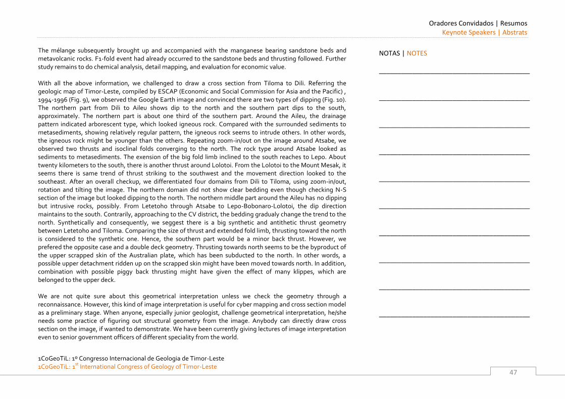
Oradores Convidados | Resumos Keynote Speakers | Abstrats
1CoGeoTiL: 1º Congresso Internacional de Geologia de Timor-Leste 1CoGeoTiL: 1st
International Congress of Geology of Timor-Leste
47
The mélange subsequently brought up and accompanied with the manganese bearing sandstone beds and metavolcanic rocks. F1-fold event had already occurred to the sandstone beds and thrusting followed. Further study remains to do chemical analysis, detail mapping, and evaluation for economic value. With all the above information, we challenged to draw a cross section from Tiloma to Dili. Referring the geologic map of Timor-Leste, compiled by ESCAP (Economic and Social Commission for Asia and the Pacific) , 1994-1996 (Fig. 9), we observed the Google Earth image and convinced there are two types of dipping (Fig. 10). The northern part from Dili to Aileu shows dip to the north and the southern part dips to the south, approximately. The northern part is about one third of the southern part. Around the Aileu, the drainage pattern indicated arborescent type, which looked igneous rock. Compared with the surrounded sediments to metasediments, showing relatively regular pattern, the igneous rock seems to intrude others. In other words, the igneous rock might be younger than the others. Repeating zoom-in/out on the image around Atsabe, we observed two thrusts and isoclinal folds converging to the north. The rock type around Atsabe looked as sediments to metasediments. The exension of the big fold limb inclined to the south reaches to Lepo. About twenty kilometers to the south, there is another thrust around Lolotoi. From the Lolotoi to the Mount Mesak, it seems there is same trend of thrust striking to the southwest and the movement direction looked to the southeast. After an overall checkup, we differentiated four domains from Dili to Tiloma, using zoom-in/out, rotation and tilting the image. The northern domain did not show clear bedding even though checking N-S section of the image but looked dipping to the north. The northern middle part around the Aileu has no dipping but intrusive rocks, possibly. From Letetoho through Atsabe to Lepo-Bobonaro-Lolotoi, the dip direction maintains to the south. Contrarily, approaching to the CV district, the bedding gradualy change the trend to the north. Synthetically and consequently, we seggest there is a big synthetic and antithetic thrust geometry between Letetoho and Tiloma. Comparing the size of thrust and extended fold limb, thrusting toward the north is considered to the synthetic one. Hence, the southern part would be a minor back thrust. However, we prefered the opposite case and a double deck geometry. Thrusting towards north seems to be the byproduct of the upper scrapped skin of the Australian plate, which has been subducted to the north. In other words, a possible upper detachment ridden up on the scrapped skin might have been moved towards north. In addition, combination with possible piggy back thrusting might have given the effect of many klippes, which are belonged to the upper deck. We are not quite sure about this geometrical interpretation unless we check the geometry through a reconnaissance. However, this kind of image interpretation is useful for cyber mapping and cross section model as a preliminary stage. When anyone, especially junior geologist, challenge geometrical interpretation, he/she needs some practice of figuring out structural geometry from the image. Anybody can directly draw cross section on the image, if wanted to demonstrate. We have been currently giving lectures of image interpretation even to senior government officers of different speciality from the world.
NOTAS | NOTES
_________________________________________
_________________________________________
_________________________________________
_________________________________________
_________________________________________
_________________________________________
_________________________________________
_________________________________________
_________________________________________
_________________________________________
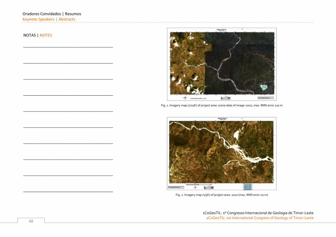
Oradores Convidados | Resumos Keynote Speakers | Abstracts
1CoGeoTiL: 1º Congresso Internacional de Geologia de Timor-Leste
1CoGeoTiL: 1st International Congress of Geology of Timor-Leste
48
Fig. 1. Imagery map (1/25K) of project area: scene date of image-2010, max. RMS error 120 m
Fig. 2. Imagery map (1/5K) of project area: 2010 (max. RMS error 20 m)
NOTAS | NOTES
_________________________________________
_________________________________________
_________________________________________
_________________________________________
_________________________________________
_________________________________________
_________________________________________
_________________________________________
_________________________________________
_________________________________________
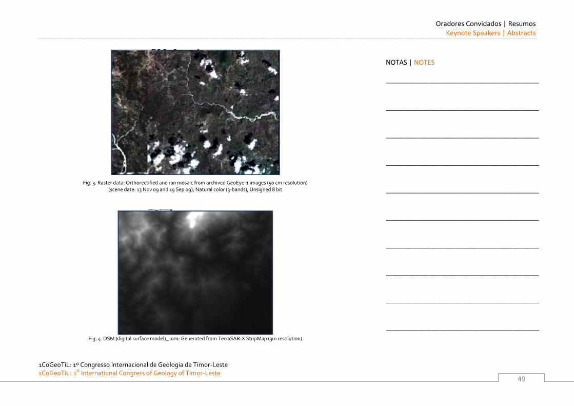
Oradores Convidados | Resumos Keynote Speakers | Abstracts
1CoGeoTiL: 1º Congresso Internacional de Geologia de Timor-Leste 1CoGeoTiL: 1st
International Congress of Geology of Timor-Leste
49
Fig. 3. Raster data: Orthorectified and ran mosaic from archived GeoEye-1 images (50 cm resolution) (scene date: 13 Nov 09 and 19 Sep 09), Natural color (3-bands), Unsigned 8 bit
Fig. 4. DSM (digital surface model)_10m: Generated from TerraSAR-X StripMap (3m resolution)
NOTAS | NOTES
_________________________________________
_________________________________________
_________________________________________
_________________________________________
_________________________________________
_________________________________________
_________________________________________
_________________________________________
_________________________________________
_________________________________________
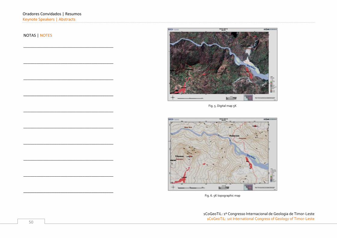
Oradores Convidados | Resumos Keynote Speakers | Abstracts
1CoGeoTiL: 1º Congresso Internacional de Geologia de Timor-Leste
1CoGeoTiL: 1st International Congress of Geology of Timor-Leste
50
Fig. 5. Digital map 5K
Fig. 6. 5K topographic map
NOTAS | NOTES
_________________________________________
_________________________________________
_________________________________________
_________________________________________
_________________________________________
_________________________________________
_________________________________________
_________________________________________
_________________________________________
_________________________________________
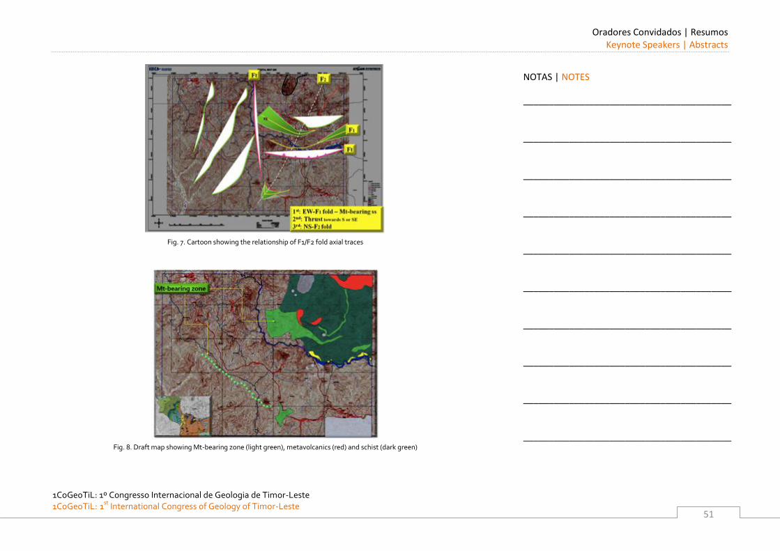
Oradores Convidados | Resumos Keynote Speakers | Abstracts
1CoGeoTiL: 1º Congresso Internacional de Geologia de Timor-Leste 1CoGeoTiL: 1st
International Congress of Geology of Timor-Leste
51
Fig. 7. Cartoon showing the relationship of F1/F2 fold axial traces
Fig. 8. Draft map showing Mt-bearing zone (light green), metavolcanics (red) and schist (dark green)
NOTAS | NOTES
_________________________________________
_________________________________________
_________________________________________
_________________________________________
_________________________________________
_________________________________________
_________________________________________
_________________________________________
_________________________________________
_________________________________________
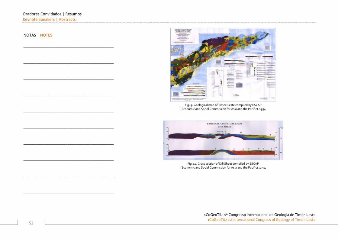
Oradores Convidados | Resumos Keynote Speakers | Abstracts
1CoGeoTiL: 1º Congresso Internacional de Geologia de Timor-Leste
1CoGeoTiL: 1st International Congress of Geology of Timor-Leste
52
Fig. 9. Geological map of Timor-Leste compiled by ESCAP
(Economic and Social Commission for Asia and the Pacific), 1994
Fig. 10. Cross section of Dili Sheet compiled by ESCAP
(Economic and Social Commission for Asia and the Pacific), 1994
NOTAS | NOTES
_________________________________________
_________________________________________
_________________________________________
_________________________________________
_________________________________________
_________________________________________
_________________________________________
_________________________________________
_________________________________________
_________________________________________
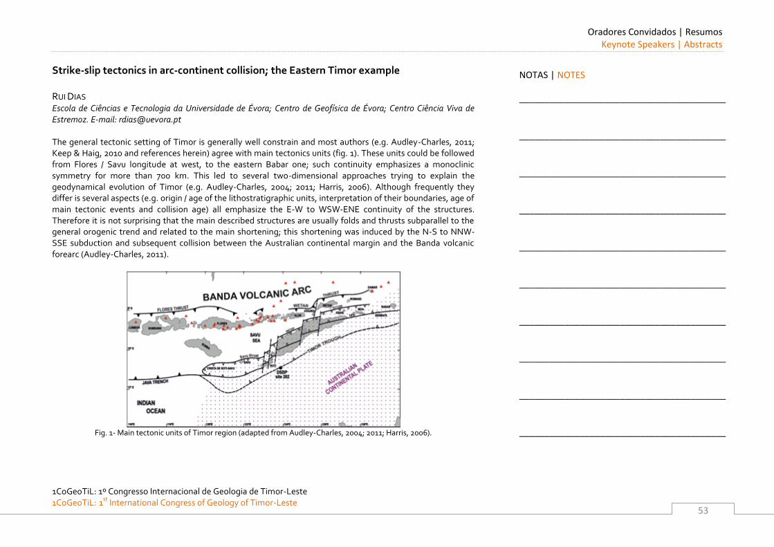
Oradores Convidados | Resumos Keynote Speakers | Abstracts
1CoGeoTiL: 1º Congresso Internacional de Geologia de Timor-Leste 1CoGeoTiL: 1st
International Congress of Geology of Timor-Leste
53
Strike-slip tectonics in arc-continent collision; the Eastern Timor example
RUI DIAS Escola de Ciências e Tecnologia da Universidade de Évora; Centro de Geofísica de Évora; Centro Ciência Viva de Estremoz. E-mail: [email protected] The general tectonic setting of Timor is generally well constrain and most authors (e.g. Audley-Charles, 2011; Keep & Haig, 2010 and references herein) agree with main tectonics units (fig. 1). These units could be followed from Flores / Savu longitude at west, to the eastern Babar one; such continuity emphasizes a monoclinic symmetry for more than 700 km. This led to several two-dimensional approaches trying to explain the geodynamical evolution of Timor (e.g. Audley-Charles, 2004; 2011; Harris, 2006). Although frequently they differ is several aspects (e.g. origin / age of the lithostratigraphic units, interpretation of their boundaries, age of main tectonic events and collision age) all emphasize the E-W to WSW-ENE continuity of the structures. Therefore it is not surprising that the main described structures are usually folds and thrusts subparallel to the general orogenic trend and related to the main shortening; this shortening was induced by the N-S to NNW-SSE subduction and subsequent collision between the Australian continental margin and the Banda volcanic forearc (Audley-Charles, 2011).
Fig. 1- Main tectonic units of Timor region (adapted from Audley-Charles, 2004; 2011; Harris, 2006).
NOTAS | NOTES
_________________________________________
_________________________________________
_________________________________________
_________________________________________
_________________________________________
_________________________________________
_________________________________________
_________________________________________
_________________________________________
_________________________________________
Oradores Convidados | Resumos Keynote Speakers | Abstracts
1CoGeoTiL: 1º Congresso Internacional de Geologia de Timor-Leste
1CoGeoTiL: 1st International Congress of Geology of Timor-Leste
54
Nevertheless, often some of the regional tectonic sketches (e.g. Audley-Charles, 2004; Harris, 2006) show major N-S to NNE-SSW sinistral strike-slip faults that even behaves as major discontinuities during the quaternary uplift (Kaneko et al, 2007). Such structures show that the regional tectonic evolution was more complex and cannot be explained using only two-dimensional approaches. Recent detailed structural mapping at 1/25 000 scale in Cribas region (Ferreira, 2011; Oliveira, 2011) led to new data concerning, not only the geometry and kinematics of submeridian sinistral strike-slip fault system, but also emphasize its relation with the major E-W Cribas anticline. This mapping was part of a cooperation project between the Secretaria de Estado dos Recursos Naturais (SERN) of Eastern Timor and the Évora University (Portugal) and will be part of the new Manatuto 1/50 000 geological map. CRIBAS GEOLOGY
The Cribas region has been previously mapped at small scale either at 1/200 000 (Leme, 1968; Audley-Charles, 1968), or 1/100 000 (Partoyo et al, 1995). All these studies emphasize the presence of the E-W Cribas anticline, which became one of the main structural structures of Timor. Although frequently referred until recently (Ferreira, 2011; Oliveira, 2011) its geometry is poorly understood. The recent map shows (fig. 2) an open fold (both limbs plunge close to 25º) , with a subvertical axial plane and a subhorizontal axis with two periclinal closures; in both limbs are frequently found second order folds with geometries compatible with the major Cribas anticline. All these structures are the older tectonic ones that could be put in evidence in the region, being considered due to the first and main tectonic event (D1; Ferreira, 2011; Oliveira, 2011). The D1 folds never develops a coeval associated cleavage, indicating that the observed deformation was attained in an upper structural level.
NOTAS | NOTES
_________________________________________
_________________________________________
_________________________________________
_________________________________________
_________________________________________
_________________________________________
_________________________________________
_________________________________________
_________________________________________
_________________________________________
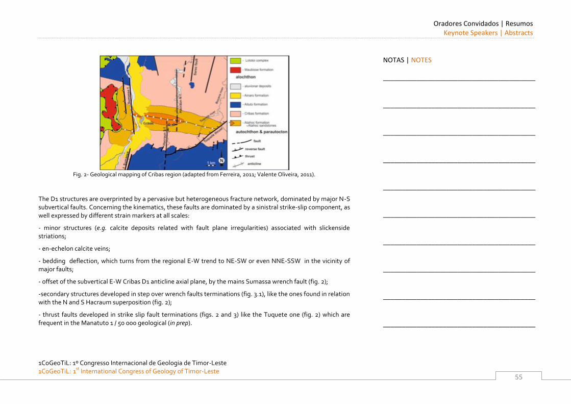
Oradores Convidados | Resumos Keynote Speakers | Abstracts
1CoGeoTiL: 1º Congresso Internacional de Geologia de Timor-Leste 1CoGeoTiL: 1st
International Congress of Geology of Timor-Leste
55
Fig. 2- Geological mapping of Cribas region (adapted from Ferreira, 2011; Valente Oliveira, 2011).
The D1 structures are overprinted by a pervasive but heterogeneous fracture network, dominated by major N-S subvertical faults. Concerning the kinematics, these faults are dominated by a sinistral strike-slip component, as well expressed by different strain markers at all scales:
- minor structures (e.g. calcite deposits related with fault plane irregularities) associated with slickenside striations;
- en-echelon calcite veins;
- bedding deflection, which turns from the regional E-W trend to NE-SW or even NNE-SSW in the vicinity of major faults;
- offset of the subvertical E-W Cribas D1 anticline axial plane, by the mains Sumassa wrench fault (fig. 2);
-secondary structures developed in step over wrench faults terminations (fig. 3.1), like the ones found in relation with the N and S Hacraum superposition (fig. 2);
- thrust faults developed in strike slip fault terminations (figs. 2 and 3) like the Tuquete one (fig. 2) which are frequent in the Manatuto 1 / 50 000 geological (in prep).
NOTAS | NOTES
_________________________________________
_________________________________________
_________________________________________
_________________________________________
_________________________________________
_________________________________________
_________________________________________
_________________________________________
_________________________________________
_________________________________________
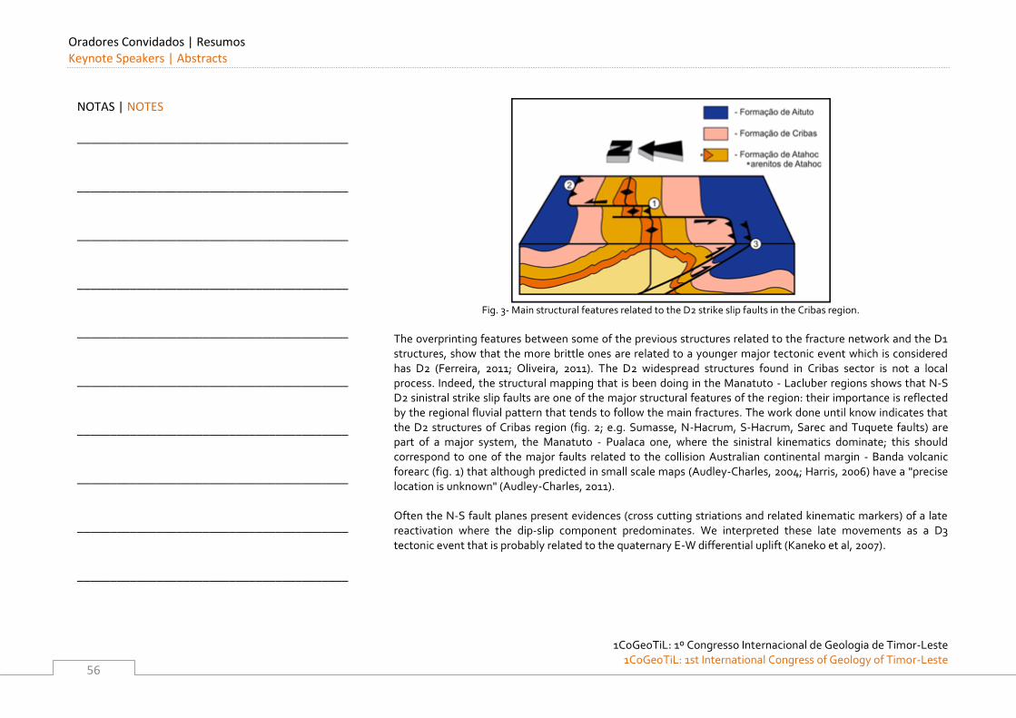
Oradores Convidados | Resumos Keynote Speakers | Abstracts
1CoGeoTiL: 1º Congresso Internacional de Geologia de Timor-Leste
1CoGeoTiL: 1st International Congress of Geology of Timor-Leste
56
Fig. 3- Main structural features related to the D2 strike slip faults in the Cribas region.
The overprinting features between some of the previous structures related to the fracture network and the D1 structures, show that the more brittle ones are related to a younger major tectonic event which is considered has D2 (Ferreira, 2011; Oliveira, 2011). The D2 widespread structures found in Cribas sector is not a local process. Indeed, the structural mapping that is been doing in the Manatuto - Lacluber regions shows that N-S D2 sinistral strike slip faults are one of the major structural features of the region: their importance is reflected by the regional fluvial pattern that tends to follow the main fractures. The work done until know indicates that the D2 structures of Cribas region (fig. 2; e.g. Sumasse, N-Hacrum, S-Hacrum, Sarec and Tuquete faults) are part of a major system, the Manatuto - Pualaca one, where the sinistral kinematics dominate; this should correspond to one of the major faults related to the collision Australian continental margin - Banda volcanic forearc (fig. 1) that although predicted in small scale maps (Audley-Charles, 2004; Harris, 2006) have a "precise location is unknown" (Audley-Charles, 2011). Often the N-S fault planes present evidences (cross cutting striations and related kinematic markers) of a late reactivation where the dip-slip component predominates. We interpreted these late movements as a D3 tectonic event that is probably related to the quaternary E-W differential uplift (Kaneko et al, 2007).
NOTAS | NOTES
_________________________________________
_________________________________________
_________________________________________
_________________________________________
_________________________________________
_________________________________________
_________________________________________
_________________________________________
_________________________________________
_________________________________________
Oradores Convidados | Resumos Keynote Speakers | Abstracts
1CoGeoTiL: 1º Congresso Internacional de Geologia de Timor-Leste 1CoGeoTiL: 1st
International Congress of Geology of Timor-Leste
57
N-S TO NNE-SSW STRIKE SLIP D2 FAULTS; A GENETICAL MECHANISM
As previously described, the D2 fault pattern are superimposed on the D1 structures, that in Cribas region has a predominant E-W trend. The overprinting relations, as well as the close orthogonality between major structures trend, indicate that they are related to different tectonics events, although in the same plate tectonic context. We propose that the D2 faults have been the result of the irregularities of the Australian continental margin. Such irregularities should have induced a diachronic arrival of the Australian margin to the subduction zone; the blocking of the subduction predicted by Audley-Charles (2004) must than have occurred at different times. If we admit that the blocking occurred first at West and propagates towards East, this should have induced N-S sinistral major faults in order to accommodate the deformation in the tectonic collision zone. This geotectonic setting is consistent with the paleogeography recently proposed (Hall, 2011) where the major Banda embayment at East should have slightly delayed the blocking of the subduction is this eastern region. This first order continental margin irregularity, doesn't exclude the existence of minor ones, due to the existence of smaller promontories (as predicted by Keep & Haig, 2010) that should have generated local structural perturbations in a more consistent regional tectonic pattern. ACKNOWLEDGEMENTS
This work is integrated in a bilateral cooperation project between the Secretaria de Estado dos Recursos Naturais (SERN) of Eastern Timor and the Évora University (Portugal), coordinated by Pedro Nogueira of Évora University. This work should not be possible without the strong cooperation of Gabriel Oliveira and Valente Ferreira. REFERENCES
Audley-Charles, M. (1968). The geology of Portuguese Timor. Mem. Geol. Soc. Lond. 4, 76 p.
Audley-Charles, M. (2004). Ocean trench blocked and obliterated by Banda forearc collision with Australian proximal continental slope. Tectonophysics 389 (2004) 65–79.
Audley-Charles, M. (2011). Tectonic post-collision processes in Timor. in Hall, R., Cottam, M. A. & Wilson, M. E. J. (eds) The SE Asian Gateway: History and Tectonics of the Australia–Asia Collision. Geological Society, London, Special Publications, 355, 241–266.
NOTAS | NOTES
_________________________________________
_________________________________________
_________________________________________
_________________________________________
_________________________________________
_________________________________________
_________________________________________
_________________________________________
_________________________________________
_________________________________________
Oradores Convidados | Resumos Keynote Speakers | Abstracts
1CoGeoTiL: 1º Congresso Internacional de Geologia de Timor-Leste
1CoGeoTiL: 1st International Congress of Geology of Timor-Leste
58
Ferreira, V. (2011). Cartografia e estrutura da região Oeste do anticlinal de Cribas. Implicações para a génese de hidrocarbonetos, 69 p.
Hall, R. (2011). Australia–SE Asia collision: plate tectonics and crustal flow. in Hall, R., Cottam, M. A. & Wilson, M. E. J. (eds) The SE Asian Gateway: History and Tectonics of the Australia–Asia Collision. Geological Society, London, Special Publications, 355, 75-109.
Harris, R. (2007). Rise and fall of the Eastern Great Indonesian arc recorded by the assembly, dispersion and accretion of the Banda Terrane, Timor. Gondwana Research 10, 207–231.
Kaneko, Y., Maruyama, S., Kadarusman,A., Ota, T., Ishikawa, M., Tsujimori, T., Ishikawa, A., Okamoto, K., (2007). On-going orogeny in the outer-arc of the Timor–Tanimbar region, eastern Indonesia, Gondwana Research 11, 218–233.
Keep, M. & Haig, D. (2010). Deformation and exhumation in Timor: distinct stages of a young orogeny. Tectonophysics, 483, 93-111.
Leme, J. A. (1968). Breve ensaio sobre a geologia da província de Timor. Curso de Geologia de Ultramar 1, 105-161.
Oliveira, G. (2011). Cartografia e estrutura da região Este do anticlinal de Cribas. Implicações para a génese de hidrocarbonetos, MsC thesis, Évora University, 94 p.
NOTAS | NOTES
_________________________________________
_________________________________________
_________________________________________
_________________________________________
_________________________________________
_________________________________________
_________________________________________
_________________________________________
_________________________________________
_________________________________________
Oradores Convidados | Resumos Keynote Speakers | Abstracts
1CoGeoTiL: 1º Congresso Internacional de Geologia de Timor-Leste 1CoGeoTiL: 1st
International Congress of Geology of Timor-Leste
59
Stratigraphic reconstruction of Timor Leste
DAVID W. HAIG Centre for Petroleum Geoscience, School of Earth & Environment, The University of Western Australia. E-mail: [email protected]
Three distinct phases are recognized in the development of the Timor orogen, as determined from stratigraphic analysis. These include (1) initial collision and emplacement of the early nappes creating loading and diapirism (within the 9.8-5.5 Ma GTS 2004 interval), (2) a tectonic quiet interval (5.5 Ma-4.5 Ma GTS2004) that extended for over a million years and probably resulted from locking of the subduction system, and (3) a post 4.5 Ma phase of uplift, unroofing and further diapirism in response to crustal readjustment probably due to subducting slab tear. Stratigraphic relationships suggest that the collision was between the Banda Arc and an ancient Timor Plateau — a continental terrace/plateau that was contiguous with the Australian mainland and similar in morphology and bathymetry to present-day Exmouth Plateau. These phases of collision have resulted in the chaotic geology of the island. Reconstruction of the original stratigraphy relies on relative dating, mainly through biostratigraphy, of each outcrop. Tectonostratigraphic affinities of the rocks are based on interpretations of depositional environments, facies associations, comparison of coeval units, and biogeographic considerations. The present assessment is based on studies by UWA researchers from 2003 to 2011 that have resulted in significant revisions of the stratigraphy.
Four main tectonostratigraphic units are recognized in Timor: (1) Gondwana Megasequence deposited in the East Gondwana Rift System during the latest Carboniferous to Middle Jurassic; (2) the Australian-Margin Megasequence deposited initially during the Late Jurassic on a marginal shelf following continental breakup and then from the Early Cretaceous to early Late Miocene on a broad lower to middle bathyal terrace/plateau contiguous with the Australian mainland; (3) Banda Terrane with Mesozoic metamorphic basement and sedimentary cover units of Asian affinity emplaced on the Australian margin during the Late Miocene; and (4) Synorogenic Megasequence deposited during the latest Miocene to Pleistocene in basins developed after the first phase of collision.
The unmetamorphosed part of the Gondwana Megasequence cannot be interpreted in terms of layer-cake stratigraphy but instead includes evidence of a complex array of facies deposited in evolving interior-rift basins. In the recognition of formations, it is impossible to define type sections that include the stratigraphic base and top of the unit as well as a complete stratigraphic section. Formations that have been described and mapped are facies units. A facies model relating the development of typical successions to climate and water-quality parameters (particularly wave base and fresh-water deltaic inflow) is used to differentiate the major lithostratigraphic units.
NOTAS | NOTES
_________________________________________
_________________________________________
_________________________________________
_________________________________________
_________________________________________
_________________________________________
_________________________________________
_________________________________________
_________________________________________
_________________________________________
Oradores Convidados | Resumos Keynote Speakers | Abstracts
1CoGeoTiL: 1º Congresso Internacional de Geologia de Timor-Leste
1CoGeoTiL: 1st International Congress of Geology of Timor-Leste
60
Age determinations are difficult and depend on integrated biostratigraphy using especially palynomorphs, conodonts, and foraminifera. For the uppermost Carboniferous and Permian the following lithostratigraphic units are recognized: (1) Cribas Group including the Atahoc beds (Early Permian; ?Asselian-?Artinskian) with a basal unit of massive quartz sandstone overlain by indurated finely laminated black shale, and the Cribas beds (Early to Late Permian; Sakmarian-Wuchiapingian) with mainly micaceous mudstone and quartz sandstone, varicoloured in many outcrops and with minor skeletal limestone and minor interlayered volcanics; (2) Maubisse Group (latest Carboniferous to Late Permian; Gzhelian-Wuchiapingian) including platform carbonate facies with some small bioherms but mainly large lensoid accumulations of bryozoan and crinoidal debris forming thick bedded indurated skeletal limestone, mostly red and pink, and some minor basic volcanic rocks; and (3) a “Volcanic” Group mainly basic volcanic flows and massive agglomerates. For the Triassic the following units are recognized: (1) “Bandeira” Group of platform-carbonate deposits of Ladinian to Late Triassic age, including skeletal, peloidal and oolitic packstone, grainstone and wackestone; (2) Aitutu Group (Middle-Late Triassic to possibly earliest Jurassic) including basinal carbonates (thin to thick bedded radiolarian-rich grey wackestone) and shale; (3) Babulu Group (Early-Late Triassic) including well-bedded sandstone and shale; and (4) Lilu beds (Early to Late Triassic) formed by red ammonoid-bearing wackestone. The Lower Jurassic is represented by (1) “Perdido” Group including “Bahaman Facies” of thick bedded to massive peloidal, oolitic, intraclastic packstone, grainstone and wackestone; and (2) Wai Luli Group (Early Jurassic and possibly Late Triassic) including blue-grey marls and calcilutites overlain by calcareous shales. The Australian-Margin Megasequence at its base includes a siliciclastic shallow marine unit with a circum-Australian-Antarctic molluscan fauna of the Upper Jurassic and a wackestone unit containing probable calpionellids of latest Jurassic to earliest Creatceous age. Stratigraphically higher is a radiolarian-rich bathyal unit of the Early Cretaceous and varicoloured carbonate pelagites of late Early Cretaceous to early Late Miocene. This reconstructed succession is interpreted as indicating subsidence of the continental shelf during the latest Jurassic to earliest Cretaceous to form a broad terrace/plateau contiguous with present-day Scott Plateau and similar to Exmouth, Wallaby, and Naturaliste Plateaus on the present-day western Australian margin. Lithostratigraphic units recognized are: (1) Oebatt Group (Late Jurassic) including varicoloured mudstone with concentrations of Malayomaorica and Inoceramus; (2) Kolbano Group (Early Cretaceous – early Late Miocene) including radiolarian-rich pelagites (Aptian) and planktonic foraminiferal wackestone and less common packstone (Aptian to early Late Miocene). Subdivision of the Kolbano Group by colour is inconsistent with chronostratigraphy. In many places, stylobedding in the cemented pelagites does not reflect original bedding.
NOTAS | NOTES
_________________________________________
_________________________________________
_________________________________________
_________________________________________
_________________________________________
_________________________________________
_________________________________________
_________________________________________
_________________________________________
_________________________________________
Oradores Convidados | Resumos Keynote Speakers | Abstracts
1CoGeoTiL: 1º Congresso Internacional de Geologia de Timor-Leste 1CoGeoTiL: 1st
International Congress of Geology of Timor-Leste
61
The Banda Terrane is formed of metamorphic basement (Lolotoi and Mutis Complexes with Rb/Sr ages of 32-200 Ma according to Harris, 2006, Gondwana Research 10) and cover units that range from possible Jurassic to earliest Miocene. The cover units have discordant facies to those represented in coeval units of the Australian-Margin Megasequence. The age of the metamorphics and the facies represented in the cover units suggest that the Banda Terrane is of Asian affinity. Lithostratigraphic units recognized include: (1) Palelo Group (Jurassic, Cretaceous?) including volcanics, agglomerates, tuffs, radiolarian cherts and limestone; (2) un-named unit (Early to Middle Eocene) including outer neritic to upper bathyal mudstone and fine muddy sandstone; (3) Dartollu Group including platform carbonates of the Middle Eocene and Late Eocene; (4) Barique Group (? Eocene) including massive basic volcaniclastics associated with minor neritic limestone; (5) Booi Group including platform carbonates and associated sandstone and mudstone of the latest Oligocene to earliest Miocene. Because of unconformable contacts, demonstrated in West Timor (by, for example, Tappenbeck), between cover units deposited in the inner neritic zone and metamorphic basement, the Banda Terrane has been in a high crustal position since at least the Middle Eocene.
The Synorogenic Megasequence (latest Miocene to Pleistocene) includes deposits laid down in basins that developed after the first phase of collision (i.e. after about 5.5 Ma). The deformation style in these deposits is much less complex than the highly deformed pre-collision units and the degree of diagenetic alteration is generally much less. Formations recognized for the latest Miocene to early Pleistocene interval are: (1) Batu Putih Member of Viqueque Formation (latest Miocene to Early Pliocene) including chalk and marl widespread over the island and representing a tectonically quiet phase; (2) Viqueque Formation overlying Batu Putih Member (Late Pliocene to Early Pleistocene) including middle to upper bathyal graded sandstone and conglomerate interbedded with mudstone and marl representing a record of uplift of Timor (thought to be due to high-angle faulting associated with crustal readjustment after stalled subducting slab detachment); (3) Lari Guti Member of Viqueque Formation (early Pleistocene) including upper bathyal coral-debris slide deposit, planktonic foram grainstones, and sandy mudstone; (4) Baucau Limestone (Pleistocene) including inner neritic coral-algal-foram limestone. Within this zone N18 to N23 succession, ranging from latest Miocene to Pleistocene, there is no major unconformity (e.g. the N20 gap suggested by some workers). Bathymetric reconstructions for the N18 to N20 interval (5.7-3.3 Ma) suggest that a deep foreland basin (precursor of the present Timor Sea) had developed by 5.7 Ma with uplifted areas to the north in an emerging island.
.
NOTAS | NOTES
_________________________________________
_________________________________________
_________________________________________
_________________________________________
_________________________________________
_________________________________________
_________________________________________
_________________________________________
_________________________________________
_________________________________________
Oradores Convidados | Resumos Keynote Speakers | Abstracts
1CoGeoTiL: 1º Congresso Internacional de Geologia de Timor-Leste
1CoGeoTiL: 1st International Congress of Geology of Timor-Leste
62
Structural mélange zones, resulting from diapirism, contain disjunct blocks (from pre-collisional units) that range from centimetres to tens of metres in size in a scaley clay matrix. These zones are part of the Bobonaro Scaley Clay of Audley-Charles 1968 (Memoir Geological Society of London 4). Other units originally mapped as Bobonaro Scaley Clay include massive highly deformed friable mudstone with widely spaced interbeds of either cemented laminated micaceous quartz sandstone (<2 m thick, in places with swaley or hummocky cross-bedding) or radiolarian-rich wackestone, often displaying “broken-formation” deformation. Both the matrix and the indurated interbeds/blocks are of the same Middle to Late Triassic age. These units are placed within the Babulu Group (containing sandstone) or the Aitutu Group (containing wackestone).
NOTAS | NOTES
_________________________________________
_________________________________________
_________________________________________
_________________________________________
_________________________________________
_________________________________________
_________________________________________
_________________________________________
_________________________________________
_________________________________________
Oradores Convidados | Resumos Keynote Speakers | Abstracts
1CoGeoTiL: 1º Congresso Internacional de Geologia de Timor-Leste 1CoGeoTiL: 1st
International Congress of Geology of Timor-Leste
63
Free at Last: New Data Helps Timor Leste Redefine the Processes of Arc-Continent
Collision
RON HARRIS Brigham Young University, USA. E-mail: [email protected] Arc continent collisional processes are commonly over-simplified in everything from introductory textbooks to complex tectonic reconstructions. The cartoon-like diagrams of arc-continent collisions originally published by Dewey and Bird in 1970 to explain field relations from ancient collision zones remain the status quo. It is modern arc-continent collisions, such as the Banda Arc, that have sufficient temporal and spatial resolution to inform us of what really happens when an old passive continental margin collides with an arc. However, in the Banda Arc the models arrived before the data. These models are supported by several untested assumptions that have held hostage the geological understanding of the Timor region for several decades, such as: 1) old continental lithosphere cannot subduct, 2) the oceanic part of the subducting slab tears off causing rebound of the continental part of the slab, and 3) arc-continent collision causes a reversal in subduction polarity. Does the Timor region fit this 42-year-old model for arc-continent or not? Continental Subduction - How far ‘down under’ can an old continental margin such as Australian subduct? There are several ways to get at this issue in the Banda Arc. The first is a simple plate reconstruction. Both the long-term NUVEL-1 plate motion vector and the decadal one measured using GPS are essentially the same and indicate NNE convergence of the Australian continent with the Banda Arc at a rate of around 70 mm/a. Recent studies of Australian plate motion show that this vector has not changed within at least the past 10 Ma. In order to determine if the continental margin has subducted, and if so, how far, we need to know when the Australian continent first arrive at the Banda Trench. The time of first arrival is bracketed between the youngest age of Australian affinity units accreted to the Banda Trench, and the oldest age of syn-collisional sedimentation and metamorphism. These ages all cluster at around 6-8 Ma in East Timor and generally young to the west along orogenic strike.
NOTAS | NOTES
_________________________________________
_________________________________________
_________________________________________
_________________________________________
_________________________________________
_________________________________________
_________________________________________
_________________________________________
_________________________________________
_________________________________________
Oradores Convidados | Resumos Keynote Speakers | Abstracts
1CoGeoTiL: 1º Congresso Internacional de Geologia de Timor-Leste
1CoGeoTiL: 1st International Congress of Geology of Timor-Leste
64
At a convergence rate of 70 km/Ma these results predict that between 420 and 560 km of the Australian continental margin has subducted beneath the Timor and Wetar region. The geometry of the subduction zone requires around 200 km of subduction for the continental margin to reach a Benioff zone depth where arc magmas are generated. The time required for this much subduction is around 3 Ma. If subduction of the continental margin started at around 8 Ma in the Timor region then there should be some indication of continental contamination of the arc by at least 5 Ma. Indeed, the volcanic rocks of Wetar show the first hints of continental contamination by 5 Ma, and the amount of contamination increases upsection. The contamination of the arc by continental crust also progressively increases in space. From the Wetar region the contamination front spreads to successively younger volcanoes both east and west from Wetar. These temporal and spatial patterns of arc contamination discredit my earlier hypothesis that the Banda Arc is contaminated by continental rocks it is mounted on. Other effects caused by subduction of the continental margin are immediate uplift of the overlying forearc accretionary wedge and forearc basin, which generally increases in magnitude from Sumba where collision is initiating to Timor where collision is more mature. The ages of turbiditic synorogenic sediment found in accretionary wedge slope basins is also consistent with general orogenic propagation to the WSW through time. Two other hypotheses from the ‘occupying’ arc-continent collision model that do not fit the Banda Arc very well is that collision causes reversal of subduction polarity and slab tear. Volcanism is still active in most parts of the Banda Arc even though with the Australian continental margin is ongoing. In the Wetar region volcanism may have shifted around 100 km to the north. Back arc thrusting has also shifted Wetar around 55 km to NNE, but there is no evidence of reversal of subduction polarity as is assumed in most models for arc-continent collision. Also, tomographic images through the Wetar region do show what is interpreted as a continental slab to at least 300 km depth without any evidence of slab tear. Other predictions for slab tear, such as a long-wavelength systematic regional uplift are inconsistent with detailed observations of uplifted coral terraces. The fate of the Banda forearc slab also contrasts with the current model of arc-continent collision in the Timor region. Some of the forearc is obviously thrust over the subducting continental margin to form the classic high-level crystalline nappes of the Banda Terrane in Timor. However, the remainder of the forearc progressively narrows in width from 200 km near Savu to 20 km near Dili. South-dipping thrusts at the rear of the accretionary wedge bound the southern edge of the forearc indicating that it is sinking beneath the orogen, but how deep? This question is best addressed by gravity modeling, since the forearc is much more dense than both the arc and continent on either side. Gravity measurements across both East and West Timor show some of the steepest gradients known on Earth.
NOTAS | NOTES
_________________________________________
_________________________________________
_________________________________________
_________________________________________
_________________________________________
_________________________________________
_________________________________________
_________________________________________
_________________________________________
_________________________________________
Oradores Convidados | Resumos Keynote Speakers | Abstracts
1CoGeoTiL: 1º Congresso Internacional de Geologia de Timor-Leste 1CoGeoTiL: 1st
International Congress of Geology of Timor-Leste
65
To account for the extremely high values observed over the Wetar Strait gravity models require that the majority of the Banda forearc is subducted to depths of at least 200 km, which discredits my previous hypothesis that the it inserts into the Australian continental margin. Subducting the forearc explains the narrowness of the gap between syn-collisional metamorphic rocks of Australian affinity cropping out near Dili and arc rocks of Atuaro across the Wetar Strait. These metamorphic rocks yield high pressures and medium to high temperatures indicating that they have come from depths of >30 km to the surface in the past 6-7 Ma, which is a rock uplift rate of >3 mm/a. Uplift rates calculated using age and depth relations on foraminifera in syn-orogenic sediment are similar. However, these rates vary in time. Initial high rates correspond to underthrusting of the continental margin beneath the forearc as is currently happening west of Timor to give rise to Sumba and Savu. Another major phase of uplift corresponds to underthrusting of the continental shelf, which is currently happening in the Timor region. The inherited structure of the continental margin also exerts a major control on variations in the thickness of sedimentary basins entering the Timor Trough. Two basement highs of the Australian continental margin are colliding with Banda arc at West Timor and East of Timor. Slightly lower and much more irregular uplift rates are measured using coral terraces, which contain a record of the past 0.5 m.y. Large sections of coastline throughout Timor and the surrounding islands are mantled with uplifted coral terraces. However, detailed studies of uplift rates and patterns show that the terraces are warped at short wavelengths that correlated with active faults and folds. The simplest explanation for the uplift pattern is explored using finite-element geodynamic models of the Timor region. These models predict a horizontal velocity field that are constrained by observed GPS velocities and rock and surface uplift rates throughout the collision zone. The best-fit between predicted and observed horizonatal and vertical motions is obtained simply by increased coupling along the subduction interface. Adding back arc thrusts to the model improves the fit. Increased coupling along the subduction interface due to increased buoyancy of the Australian continental margin, and the addition of active faults explains the deformation pattern in the Timor region without slab tear or subduction polarity reversal. Some of these faults may be much more active than previously thought. For example, historical records as far back as 1600 document several large earthquakes that caused subsidence and uplift, large tsunami and years of aftershocks. Records of tsunami run-up heights observed throughout the Banda Arc during these events provide a way to reconstruct generally where the earthquakes were located and how large they were. Finite-difference modeling of the tsunami record yielded moment magnitudes of up to 9.0 along the Seram and Timor Troughs, and 8.0 along the Flores Thrust to produce the tsunami run-up heights observed throughout the Banda Sea region. In this region there were 32 significant earthquakes and 29 tsunami from 1629 to 1877.
NOTAS | NOTES
_________________________________________
_________________________________________
_________________________________________
_________________________________________
_________________________________________
_________________________________________
_________________________________________
_________________________________________
_________________________________________
_________________________________________
Oradores Convidados | Resumos Keynote Speakers | Abstracts
1CoGeoTiL: 1º Congresso Internacional de Geologia de Timor-Leste
1CoGeoTiL: 1st International Congress of Geology of Timor-Leste
66
Since this time few of these events are documented. During the 155 years of quiescence large amounts of elastic strain energy has accumulated in the region and poses a significant threat of large earthquakes and tsunami hazards to a much more densely populated region than in the past.
NOTAS | NOTES
_________________________________________
_________________________________________
_________________________________________
_________________________________________
_________________________________________
_________________________________________
_________________________________________
_________________________________________
_________________________________________
_________________________________________
Oradores Convidados | Resumos Keynote Speakers | Abstracts
1CoGeoTiL: 1º Congresso Internacional de Geologia de Timor-Leste 1CoGeoTiL: 1st
International Congress of Geology of Timor-Leste
67
Recursos Geológicos e Desenvolvimento Sustentável: Rochas Industriais e Ornamentais
LUÍS LOPES Universidade de Évora, Departamento de Geociências, Associação Valor Pedra e Centro de Geofísica de Évora. Rua Romão Ramalho, 59; 7002 554 ÉVORA – PORTUGAL. E-mail: [email protected] Mais do que nunca, no Século XXI a dependência em georrecursos é um factor de desenvolvimento crucial em qualquer Sociedade. Em todas as economias emergentes e apesar da na maior parte dos casos o seu crescimento económico estar associado à riqueza em determinado recurso geológico, de um modo geral, a demanda destas matérias-primas é largamente superior à oferta, o que acaba por condicionar o seu próprio desenvolvimento. Deste modo os projectos de cartografia geológica e mineira, com o reconhecimento, inventariação, classificação e quantificação de georrecursos, são factores cruciais para o desenvolvimento sustentável de qualquer País. Só se pode desenvolver uma indústria em torno de um georrecurso se já houver um conhecimento do território que permita elaborar um plano integrado envolvendo o território, as populações e os interesses económicos quer do País quer das empresas que o pretendam explorar. Nas Sociedades onde existe uma grande ocupação do território, a ocorrência de determinado georrecurso frequentemente causa conflitos de interesses entre populações e a Indústria. Por outro lado, em locais isolados pode constituir um pólo de desenvolvimento e gerar oportunidades de negócio com impacto directo na economia local ou mesmo regional, no entanto reforçamos que é fundamental haver um correcto conhecimento geológico e envolver desde a primeira hora as comunidades locais a todos os níveis. Nesta apresentação iremos debruçar-nos sobre os recursos minerais não metálicos que são usualmente divididos em: i) minerais industriais; ii) rochas industriais e iii) rochas ornamentais. Estas últimas estão associadas a um conceito de dimensão (Dimension Stones na terminologia anglo-saxónica) que permita a obtenção de blocos, normalmente de forma paralelepipédica com dimensões até 3m x 2m x 2m pelo facto de se lhe associar a ideia de transformação industrial em chapas com espessuras variáveis a partir de 12mm, que posteriormente são transformadas em ladrilhos de várias dimensões padrão e outras peças por medidas.
NOTAS | NOTES
_________________________________________
_________________________________________
_________________________________________
_________________________________________
_________________________________________
_________________________________________
_________________________________________
_________________________________________
_________________________________________
_________________________________________
Oradores Convidados | Resumos Keynote Speakers | Abstracts
1CoGeoTiL: 1º Congresso Internacional de Geologia de Timor-Leste
1CoGeoTiL: 1st International Congress of Geology of Timor-Leste
68
Os minerais industriais (não metálicos) têm um largo espectro de aplicações essencialmente definidas em função das suas propriedades ou dos elementos químicos que contêm. As rochas industriais são essenciais para a construção civil, obras públicas e trabalhos de engenharia (normalmente designadas por “agregados”), tanto como carga sólida como matéria-prima para o fabrico de cimentos, também se utilizam nas Indústrias Química, Sidero-metalúrgica e Indústria Agro-alimentar. No que respeita às rochas ornamentais têm aplicação na construção civil essencialmente como revestimento de paredes e em pavimentos, aplicações domésticas, arte funerária, escultura, etc. Para além dos aspectos estéticos, relacionados com padrões ora homogéneos ora geométricos, definidos pela geologia e aproveitados pelo Homem, desempenham um papel fundamental na preservação de edifícios. As boas regras da utilização das rochas ornamentais implicam a sua adequada utilização que deve respeitar as características físico-mecânicas e estabilidade química, mineralógica e petrográfica de cada rocha. No Sector das Rochas Ornamentais é usual afirmar-se que não há pedras boas ou más, simplesmente há produtos bem ou mal aplicados. Um aspecto muito particular das rochas ornamentais tem a ver com o valor acrescentado destes materiais em relação aos congéneres industriais que produzem britas, balastros e materiais afins (agregados). Efectivamente todas a rochas ornamentais podem ser transformadas em rochas industriais, esta é mesmo uma aplicação dos subprodutos da indústria das rochas ornamentais, o contrário não é de todo verdade e uma pedreira ornamental que tenha passado a produzir agregados não voltará a produzir blocos ornamentais. As técnicas de extracção são substancialmente diferentes desde logo pela utilização de explosivos de alta potência que não são de todo utilizados nas rochas ornamentais. A propagação de fracturas pelo maciço dificultará a obtenção de um “bloco comerciável” (com dimensão suficiente para ser talhado e transformado em chapas numa fábrica). A título de exemplo, em Portugal o preço por tonelada de um mármore, granito, ou calcário industrial poderá custar 4-7 euros/tonelada (até 15 euros/m3). No caso de serem vendidos em bloco os mesmos materiais podem valer 100 a 200 vezes mais e em casos excepcionais como são os mármores cremes, branco ou cor-de-rosa (Rosa Portugal), explorados no anticlinal de Estremoz, 500 vezes mais. Por outro lado, as taxas de aproveitamento nas rochas ornamentais são muito baixas, por exemplo, 10 a 15% em xistos, cerca de 20% em granitos, excepcionalmente até 40% em calcários. No caso dos mármores estes valores baixam ainda mais havendo casos em que a produção não ultrapassa os 3,5% só possível pela raridade e qualidade excepcional dos materiais explorados.
NOTAS | NOTES
_________________________________________
_________________________________________
_________________________________________
_________________________________________
_________________________________________
_________________________________________
_________________________________________
_________________________________________
_________________________________________
_________________________________________
Oradores Convidados | Resumos Keynote Speakers | Abstracts
1CoGeoTiL: 1º Congresso Internacional de Geologia de Timor-Leste 1CoGeoTiL: 1st
International Congress of Geology of Timor-Leste
69
Com estas taxas de aproveitamento tão baixas resultam volumes enormes de escombreiras que embora possam ser utilizadas em várias indústrias, por norma não têm sido e daqui resultam impactos ambientais que alteram substancialmente a paisagem das regiões. Reconhecendo o potencial industrial destes materiais, no caso português, a Lei classifica-os como subprodutos e não como resíduos. Antecipando estes problemas ambientais a China, por exemplo, obrigada a que pelo menos 60% da matéria explorada numa pedreira seja integrada na indústria. Este constrangimento conduziu a soluções tecnológicas para uso de praticamente toda a matéria explorada e conduziu a um incremento exponencial na produção de materiais compactos, tanto siliciosos como carbonatados. Inicialmente de qualidade duvidosa e custos ambientais elevados pelo uso de produtos químicos nocivos, o avanço tecnológico permitiu que hoje se fabriquem materiais artificiais “amigos do ambiente” que competem seriamente com os produtos naturais por serem produzidos em série, ser possível reproduzir qualquer padrão natural ou artificial que se pretenda e apresentarem propriedades físico-mecânicas melhores ou pelo menos equiparadas às rochas naturais. Têm o contra de ainda serem mais caras e serão sempre conotadas como uma imitação ao passo que o original é único e valerá sempre mais por isso mesmo.
NOTAS | NOTES
_________________________________________
_________________________________________
_________________________________________
_________________________________________
_________________________________________
_________________________________________
_________________________________________
_________________________________________
_________________________________________
_________________________________________
Oradores Convidados | Resumos Keynote Speakers | Abstracts
1CoGeoTiL: 1º Congresso Internacional de Geologia de Timor-Leste
1CoGeoTiL: 1st International Congress of Geology of Timor-Leste
70
Cronologia dos estudos geológicos em Timor-Leste
P. NOGUEIRA Departamento de Geociências da Universidade de Évora; Centro de Geologia da Universidade do Porto. E-mail: [email protected] Este trabalho lança um olhar sobre a geologia de Timor a partir da análise e apresentação dos documentos históricos que marcaram o conhecimento geológico do sudeste asiático, em particular do território de Timor-Leste; faz-se ainda uma pesquisa e interpretação bibliográfica dos trabalhos mais recentes que marcam as principais discussões e problemas que se colocam à geologia de Timor-Leste na atualidade. O conhecimento sobre a geologia de Timor-Leste pode ser dividido em 4 grandes períodos históricos que coincidem com marcos na história nacional e mundial. O primeiro período que abarca desde o séc. XIX até o início da II Grande Guerra Mundial, inicia-se com os trabalhos dos primeiros naturalistas nos quais se incluem Wanner, Hirschi, Weber entre outros. Estes trabalhos foram essencialmente de dois tipos, numa primeira fase mais de carácter naturalista, procurando descrever e classificar a paleontologia e estratigrafia da região, tendo sido descritos fósseis e unidades geológicas, sobretudo aquelas que envolvem as idades do Pérmico e Triásico. Um segundo tipo de estudos, de índole marcadamente económica, suportados por companhias dedicadas à exploração dos territórios ultramarinos, preocuparam-se em descrever os recursos minerais e as ocorrências de petróleo e gás, sobretudo em terra (ex. Wittouck). O segundo período que decorre desde a II Grande Guerra Mundial até à ocupação indonésia do território, em 1975, onde foram lançados os fundamentos do conhecimento das unidades geológicas aflorantes em Timor-Leste, com base em trabalhos de campo realizados nas décadas de 50 e 60 do século XX. Neste período foi intensificado o conhecimento do território com a promoção de diversas missões, estudos geológicos, geoquímicos e geofísicos realizados pelo governo português e por companhias privadas. Neste período são trabalhos fundadores os de Grunau que defende a existência de uma estrutura do tipo alpino com unidades carreadas (Grunau, 1953). Os trabalhos de gravimetria realizados por G. de Snoo são também um marco no conhecimento da história do território timorense. No que diz respeito à definição de unidades cartográficas os estudos de Gageonnet e Lemoine a partir de 1955 são pioneiros, definindo as grandes formações geológicas. Azeredo Leme incluído numa missão do estado português, a partir dos anos 60 do séc. XX, fez extensos levantamentos cartográficos no território devendo-se a este autor a produção dos primeiros mapas de Ataúro e Oecussi, bem como levantamentos extensos, à escala 1:50000 da área leste do então Timor Português.
NOTAS | NOTES
_________________________________________
_________________________________________
_________________________________________
_________________________________________
_________________________________________
_________________________________________
_________________________________________
_________________________________________
_________________________________________
_________________________________________
Oradores Convidados | Resumos Keynote Speakers | Abstracts
1CoGeoTiL: 1º Congresso Internacional de Geologia de Timor-Leste 1CoGeoTiL: 1st
International Congress of Geology of Timor-Leste
71
Num trabalho de 1968 Azeredo Leme apresenta a sua síntese sobre a geologia de Timor-Leste, bem como um mapa de síntese à escala 1:500.000. É também durante essa década que Audley-Charles realiza os seus primeiros trabalhos, que conduzem à sua tese de doutoramento e posteriormente à publicação de uma memória na sociedade geológica de Londres, que apresenta uma síntese e uma reinterpretação dos trabalhos efetuados até então. Nessa memória é apresentado um mapa à escala 1:250.000. Estes trabalhos são o marco fundamental do conhecimento geológico de Timor, estabelecendo as formações geológicas e as bases da paleogeografia e tectónica de Timor. O terceiro período vai desde a ocupação indonésia de Timor-Leste em 1975 até 2002. Neste período é de referir a dificuldade em se voltar a efetuar trabalho de campo com segurança. Assim, numa análise dos trabalhos publicados sobre a geologia de Timor-Leste, a sua maioria são de reinterpretação dos trabalhos anteriores. Porém, neste período muitos trabalhos foram sendo desenvolvidos na parte ocidental da ilha. Estando Timor numa zona tectonicamente ativa e numa posição privilegiada para compreender muitos dos fenómenos relacionados com a tectónica de placas, a emergência deste novo paradigma veio trazer muitos trabalhos que procuraram reinterpretar a sua geologia à sua luz. Neste período os trabalhos apresentados de índole geral, como o levantamento geofísico e a interpretação da geologia do arquipélago indonésio pelos serviços geológicos estado-unidenses (Hamilton, 1979). São de salientar neste período também a continuação de alguns estudos dos investigadores de origem inglesa, como Harris, Charlton, Barber, Carter, etc. na continuação dos trabalhos de Audley-Charles. Autores australianos como Berry e Grady apresentam também durante este periodo estudos estruturais e de metamorfismo sobretudo na Formação de Aileu. Os autores de origem indonésia como Bachri, Harsomulakso, Partoyo, Prasetyadi, Rosidi e Tobing apresentaram trabalhos cartografia, tentando compatibilizar e atualizar a cartografia para as duas partes da ilha de Timor. O quarto e último período da história da geologia de Timor-Leste vai desde a sua independência em 2002 até à atualidade. Neste período salientam-se trabalhos de enquadramento e evolução do sudeste asiático (Audley-Charles, Hall, Ribeiro e Leme), análise e reinterpretação da estratigrafia (Charlton, Haig e Villeneuve), de trabalhos de análise estrutural (Harris e Keep). Neste período são publicados os primeiros trabalhos de geólogos timorenses, sobre o seu território. Trabalho pioneiro é o de Francisco Monteiro que aborda a estratigrafia do Triásico-Jurássico de Timor-Leste. Desde então tem sido diversos os estudantes e futuros timorenses que tem sido envolvidos em trabalhos de geologia com equipas de diferentes origens, destacando-se a Austrália, a Coreia do Sul, a Indonésia, e Portugal. Este esforço trará com certeza no futuro novos conhecimentos geológicos e benefícios para o povo de Timor-Leste. Referências Bibliográficas (ver versão em inglês)
NOTAS | NOTES
_________________________________________
_________________________________________
_________________________________________
_________________________________________
_________________________________________
_________________________________________
_________________________________________
_________________________________________
_________________________________________
_________________________________________
Oradores Convidados | Resumos Keynote Speakers | Abstracts
1CoGeoTiL: 1º Congresso Internacional de Geologia de Timor-Leste
1CoGeoTiL: 1st International Congress of Geology of Timor-Leste
72
Chronology of the geological studies in Timor-Leste
P. NOGUEIRA Departamento de Geociências da Universidade de Évora; Centro de Geologia da Universidade do Porto. E-mail: [email protected] This paper presents the history of the geological knowledge of Timor based on the analysis of published papers that can be considered milestones for the geological knowledge of the Southeast Asia, and in particular the ones related with the territory of Timor-Leste. In the presentation I cover the period that starts in the first works of the naturalists of XIX century to the most recent issues that mark the main discussions and problems that the geology of Timor-Leste faces today. The history of the knowledge of the geology of Timor-Leste can be divided into four major historical periods that coincide with some of the great periods in the national and international history. The first period that spans from the XIX century until the beginning of World War II, begins with the work of the first naturalists and includes Wanner, Hirschi, Weber among others. These works were mainly of two types: initially the naturalists prevailed, describing and classifying the paleontology and stratigraphy of the region, the fossils and the main geological units were described, especially those involving the Permian and Triassic ages. A second type of studies with a strong economic character and supported by companies (e.g. Wittouck) that were engaged in the exploration of the overseas territories, were mainly concerned with the description of the mineral resources, oil and gas occurrences, especially onshore. The second period elapses from the World War II until the Indonesian occupation of the territory in 1975. In this period the foundations of the nowadays knowledge of the geological units outcropping in East Timor were laid, mainly based on fieldwork conducted in the 50's and 60's of the XX century. This period is marked by the improvement of the knowledge of the territory with the promotion of diverse field missions: geological, geochemical and geophysical surveys conducted by the Portuguese government and private companies. This period is marked by the founding work of Grunau defending the existence of an Alpine-type structure with overthrust units. One example of this is the geophysics (gravimetric) work done G. Snoo. Regarding the definition of cartographic units the studies of Gageonnet and Lemoine begining in 1955 are pioneers, defining the main geological formations. Azeredo Leme started working in the geology of the territory included in a mission of the Portuguese government, made extensive surveys in the territory publishing the first maps of Atauro and Oecussi, as well as extensive cartography on the scale of 1:50.000 area east of the then Portuguese Timor.
NOTAS | NOTES
_________________________________________
_________________________________________
_________________________________________
_________________________________________
_________________________________________
_________________________________________
_________________________________________
_________________________________________
_________________________________________
_________________________________________
Oradores Convidados | Resumos Keynote Speakers | Abstracts
1CoGeoTiL: 1º Congresso Internacional de Geologia de Timor-Leste 1CoGeoTiL: 1st
International Congress of Geology of Timor-Leste
73
In a 1968 work Azeredo Leme presents the synthesis of the geology of East Timor. This author also published an overview geological map of Timor-Leste in the 1:500,000 scale. It is also during this decade that Audley-Charles performs his first works, leading to his doctoral thesis (1965) and a later publication of a Memory in the Geological Society of London, which presents new key aspects and a synthesis and reinterpretation of the work done so far. In this work a geological map is presented at the scale 1:250,000. I consider these works the rosetastone of the geological knowledge of Timor, establishing the geological formations and the foundations of paleogeography and tectonics of Timor discussed thereafter. The third period goes from the Indonesian occupation of Timor-Leste in 1975 until 2002, the date of the independence. During this period it is noted the difficulty in performing fieldwork safely. Thus most of the papers published are re-interpretations of previous works. However, in this period many works were being developed in the western part of the island. Timor being a tectonically active area and in a unique position to understand many of the phenomena related to plate tectonics, the emergence of this new paradigm has brought many publications that discuss and reinterpret the geology. During this period there are works presented of a general nature, such as the geophysical survey and interpretation of the geology of the Indonesian archipelago by the U.S. Geological Survey by Hamilton. It is worth mentioning in this period also the continuation of the studies of researchers from England, like Harris, Charlton, Barber, Carter, etc. and the continuation of the work of Audley-Charles. Australian authors such as Berry and Grady also presented papers during this period studying the metamorphism and the structural aspects especially of the Aileu Formation. The authors of Indonesian origin such as Bachri, Harsomulakso, Partoyo, Prasetyadi, Rosidi and Tobing presented papers and geological maps, trying to reconcile and update the knowledge of the two parts of the island of Timor. The fourth and last period of the geological history of Timor-Leste starts after the independence in 2002 and lasts until today. In this period new papers were published providing new insights to: the paleogeography and evolution of the Southeast of Asia (Audley-Charles, Hall, Ribeiro and Leme), analysis and reinterpretation of the stratigraphy (Charlton, Haig and Villeneuve), structural and tectonic studies (Harris, Keep). In this period we can find the first published work of geologists from Timor-Leste on their own territory. The work of Francisco Monteiro is pioneer addressing the Triassic-Jurassic stratigraphy of Timor-Leste. Since then there have been many Timorese students who have been involved in work with teams of different geological origins, especially Australia, Indonesia, South Korea and Portugal. This effort will surely, in the future, provide new geological knowledge and benefits to the people of Timor-Leste.
NOTAS | NOTES
_________________________________________
_________________________________________
_________________________________________
_________________________________________
_________________________________________
_________________________________________
_________________________________________
_________________________________________
_________________________________________
_________________________________________
Oradores Convidados | Resumos Keynote Speakers | Abstracts
1CoGeoTiL: 1º Congresso Internacional de Geologia de Timor-Leste
1CoGeoTiL: 1st International Congress of Geology of Timor-Leste
74
Bibliographic References
Audley-Charles, M. G., 1968. The Geology of Portuguese Timor. Mem. Geol. Soc. London 4, 1–76.
Audley-Charles, M. G., 2004. Ocean trench blocked and obliterated by Banda forearc collision with Australian proximal continental slope. Tectonophysics 389, 65–79.
Audley-Charles, M., 2011. Tectonic post-collision processes in Timor. in Hall, R., Cottam, M. A. & Wilson, M. E. J. (eds) The SE Asian Gateway: History and Tectonics of the Australia–Asia Collision. Geological Society, London, Special Publications, 355, 241–266.
Bachri, S. & Situmorang, R.L. 1994. Geological map of the Dili Sheet, East Timor. 1:250,000. GRDC.
Barber, A. J., Audley-Charles, M. G. & Carter, D. J., 1977. Thrust Tectonics in Timor. J. geol. Soc. Austral. 24, 51–62.
Berry, R.F., Grady, A.E., 1981. Deformation and metamorphism of the Aileu Formation, north coast, East Timor and its tectonic significance. Journal of Structural Geology 3, 143–167.
Charlton, T. R., Barber, A. J., McGowan, A. J., Nicoll, R. S. Roniewicz, E., Cook, S. E., Barkham, S. T. & Bird, P. R., 2009. The Triassic of Timor: Lithostratigraphy, chronostratigraphy and palaeogeography. Journal of Asian Earth Sciences 36. 341–363.
Gageonnet, R. & Lemoine, M., 1958. Contribution à la connaissance de la géologie de la province portuguaise de Timor. Estudos Ensaios Docum. Junta Invest. Ultramar Lisboa 48, 1–136.
Grunau, H. 1953. Geologie von Portugiesisch Ost-Timor: eine kurze ubersicht. Eclog. Geol. Helv. 46, 29-37.
Grunau, H. 1956. Zur geologie von Portugiesisch Ost-Timor. Mitt. Naturf. Ges. Bern 13, 11-18.
Grunau, H. 1957. Geologia da parte oriental do Timor Português. Garcia da Orta 5, 727-737.
Haig, D.W., 2004. Stratigraphic reconstruction of Timor Leste and correlation to the Bonaparte Basin (abstract). PESA (Petroleum Exploration Society of Australia) Newsletter, December.
Haig, D.W., McCartain, E.W., Keep M., & Barber, L. 2008. Re-evaluation of the Cablac Limestone at its type area, East Timor: Revision of the Miocene stratigraphy of Timor. J. Asian Earth Sci. 33(5-6), 366-378.
Hall, R., 2011. Australia–SE Asia collision: plate tectonics and crustal flow. in Hall, R., Cottam, M. A. & Wilson, M. E. J. (eds) The SE Asian Gateway: History and Tectonics of the Australia–Asia Collision. Geological Society, London, Special Publications, 355, 75-109.
NOTAS | NOTES
_________________________________________
_________________________________________
_________________________________________
_________________________________________
_________________________________________
_________________________________________
_________________________________________
_________________________________________
_________________________________________
_________________________________________
Oradores Convidados | Resumos Keynote Speakers | Abstracts
1CoGeoTiL: 1º Congresso Internacional de Geologia de Timor-Leste 1CoGeoTiL: 1st
International Congress of Geology of Timor-Leste
75
Hamilton, W. 1979. Tectonics of the Indonesian Region. U.S. Geol. Surv. Prof. Pap. 1078.
Harris, R., Sawyer, R. K. & Audley-.Charles, M., 1998. Collisional mélange development: Geologic association of active melange-forming processes with exhumed melange facies in the western Banda orogen, Indonesia. Tectonics 17, 458–479.
Harsolumakso, A. H., 1993. Etude lithostratigraphique et structurale le long du transect Wini-Kolbano à Timor Ouest (Indonésie). Unpublished Thesis, University of Nice-Sophia-Antipolis, Valbonne (Fr), 256pp.
Keep, M., Haig, D.W., 2009. Deformation and exhumation in Timor: Distinct stages of a young orogeny, Tectonophysics.
Leme, J. de Azeredo & Coelho, A.V.P. 1962. Geologia do encrave de Ocussi, Provincia de Timor. Garcia de Orto 10, 553-566.
Leme, J. de Azeredo & Pissara, J.B. 1962. Notas sobre a geologia e petrografia da ilha de Atauro (Timor). Estudos Oferecidos em Homenagem ao Prof. Carrington da Costa, Junta Inv. Ultramar, 325-348.
Leme, J. de Azeredo. 1962. The geological map of Portuguese Timor (the eastern end) – a preliminary sketch. Reg. Conf. SE Asian Geographers (Kuala Lumpur).
Leme, J. de Azeredo. 1963. The eastern end geology of Portuguese Timor. Garcia de Orta 11, 379-388.
Leme, J. de Azeredo. 1968. Breve ensaio sobre a geologia da provincia de Timor. Curso de Geologia de Ultramar 1, 105-161.
Monteiro, F. da Costa, 2003. Late Triassic strata from East Timor: stratigraphy, sedimentology and hydrocarbon potential. M.Sc. thesis, Auckland University.
O’Connor, S., Spriggs, M., Veth, P., 2002. Excavation at Lene Hara establishes occupation in East Timor at least 30,000 e 35,000 years ago: results of recent fieldwork. Antiquity 76, 45 e 50.
Partoyo, E., Hermanto, B. & Bachri, S. 1995. Geological map of the Baucau Quadrangle, East Timor. 1:250,000. GRDC.
Ribeiro, A. & Leme, J.C.A. (2010) – Geologia de Timor. In: Neiva, J.M.; Ribeiro, A.; Mendes Victor, L.; Noronha, F. & Ramalho, M. (Eds.) – Ciências Geológicas – Ensino e Investigação e sua História, Associação Portuguesa de Geólogos; Sociedade Geológica de Portugal, Vol. III: 279-284.
Rosidi, H. M. D., Suwitodridjo, K. & Tjokosopoetro, S., 1979. Geological map of Kupang-Atambua quadrangle, Timor, 1:250 000. Geol. Res. Dev. Centre, Bandung, Indonesia.
NOTAS | NOTES
_________________________________________
_________________________________________
_________________________________________
_________________________________________
_________________________________________
_________________________________________
_________________________________________
_________________________________________
_________________________________________
_________________________________________
Oradores Convidados | Resumos Keynote Speakers | Abstracts
1CoGeoTiL: 1º Congresso Internacional de Geologia de Timor-Leste
1CoGeoTiL: 1st International Congress of Geology of Timor-Leste
76
Sawyer, R. S., Brown, S. &. Kartono, S., 1993. Stratigraphy and sedimentology of West Timor, Indonesia. Proceedings of the 22nd annual Indonesian petroleum association Convention, 533–574.
Villeneuve, M., Cornée, J., Harsolumakso, A., Martini, R. & Zaninetti, L., 2005. Révision stratigraphique de l’Ile de Timor (Indonésie orientale). Eclogae Geol. Helv. 98, 297–310.
Wanner, J. (ed.) 1914-1929. Palaontologie von Timor (16 volumes). Stuttgart.
Wittouck, S.F., 1937. Exploration of Portuguese Timor. Report of Allied Mining Corp. to Asia Investment Co. Ltd., Amsterdam (Kolff).
NOTAS | NOTES
_________________________________________
_________________________________________
_________________________________________
_________________________________________
_________________________________________
_________________________________________
_________________________________________
_________________________________________
_________________________________________
_________________________________________
Oradores Convidados | Resumos Keynote Speakers | Abstracts
1CoGeoTiL: 1º Congresso Internacional de Geologia de Timor-Leste 1CoGeoTiL: 1st
International Congress of Geology of Timor-Leste
77
Desastres Naturais em Timor Leste. Tipologia dos movimentos de vertente.
D. RODRIGUES1, P. NOGUEIRA
2 1. CCCEE, Universidade da Madeira e Centro de Geologia da Universidade do Porto. E-mail: [email protected] 2. Universidade de Évora, Departamento de Geociências. Centro de Geologia da Universidade do Porto. E-mail: [email protected] As ilhas são, de uma maneira geral, mais vulneráveis aos desastres naturais devido às suas dimensões geográficas reduzidas, sendo afectadas em parte significativa do seu território, e à sua localização, em algumas das áreas de maior perigosidade do planeta, nomeadamente zonas de actividade vulcânica e sísmica muito intensa e zonas afectadas por ciclones tropicais. A sua vulnerabilidade depende não só do facto de se situarem em zonas de alta perigosidade mas também devido às fontes de riqueza destas comunidades insulares podem ser severamente afectada por uma simples catástrofe. Outra das características importantes da sua vulnerabilidade, sobretudo das ilhas menos desenvolvidas, é a impossibilidade de se restabelecerem por meios próprios quando sujeitos a eventos catastróficos e dependerem da ajuda exterior. A fragilidade das suas economias e dos seus recursos humanos impossibilitam muitas vezes o desenvolvimento e a implementação de estratégias e programas de minimização dos desastres naturais. Num estudo efectuado pela UNDRO nos anos noventa e que classificou os países em função do impacto dos desastres naturais no seu PIB, mostrou que dos 25 países mais afectados por desastre naturais, 13 eram ilhas. Timor Leste situa-se numa zona de elevada perigosidade e vulnerabilidade aos desastres naturais, quer pela sua localização geográfica, muito perto da zona de convergência de placas tectónicas (Euro-asiática e Australiana) que são zonas de vulcanismo activo e grande actividade sísmica, quer pela densidade populacional e ausência de meios de prevenção e mitigação contra os desastres naturais. As catástrofes naturais que afectam o território de Timor Leste são provocadas maioritariamente por: Inundações, Ciclones (Tempestades), Movimentos de vertente, Sismos e Tsunamis SISMOS
Dado a sua localização junto a uma zona de subducção da placa Australiana na placa euro-asiática, uma zona sismicamente activa, Timor Leste encontra-se numa zona de risco moderado mas muito perto de zonas de risco elevado de ocorrência de sismos. (Fig.1).
NOTAS | NOTES
_________________________________________
_________________________________________
_________________________________________
_________________________________________
_________________________________________
_________________________________________
_________________________________________
_________________________________________
_________________________________________
_________________________________________
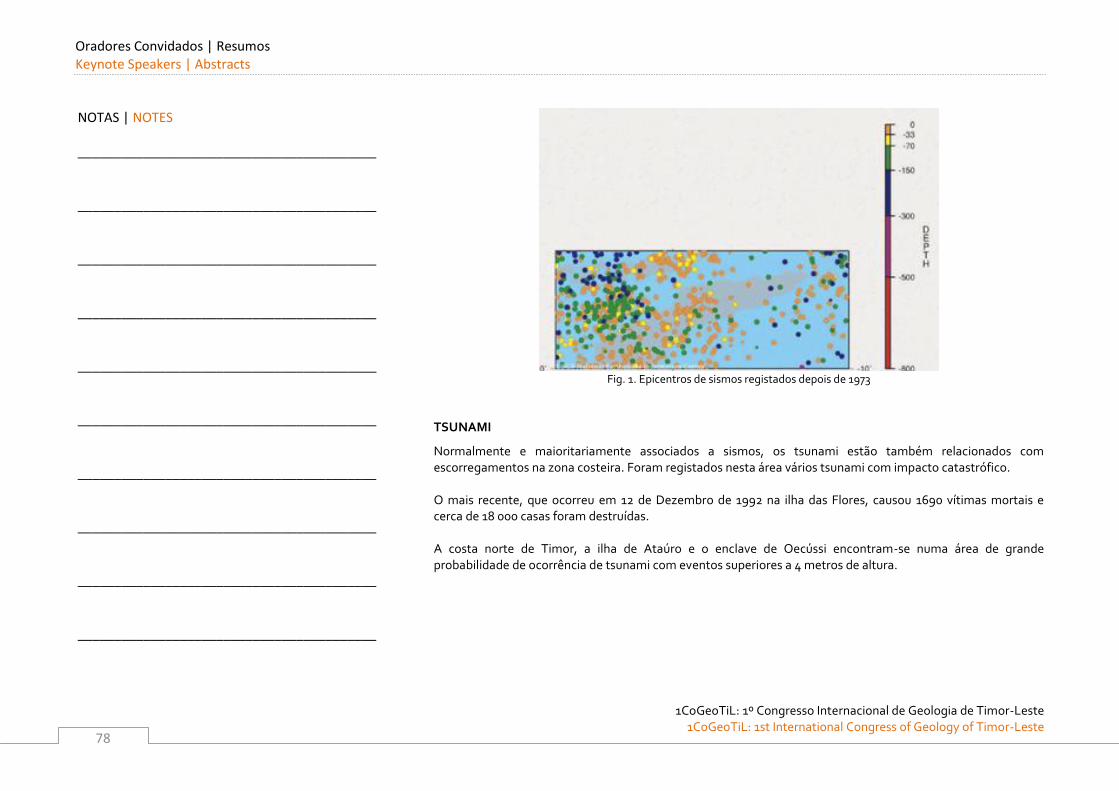
Oradores Convidados | Resumos Keynote Speakers | Abstracts
1CoGeoTiL: 1º Congresso Internacional de Geologia de Timor-Leste
1CoGeoTiL: 1st International Congress of Geology of Timor-Leste
78
Fig. 1. Epicentros de sismos registados depois de 1973
TSUNAMI
Normalmente e maioritariamente associados a sismos, os tsunami estão também relacionados com escorregamentos na zona costeira. Foram registados nesta área vários tsunami com impacto catastrófico. O mais recente, que ocorreu em 12 de Dezembro de 1992 na ilha das Flores, causou 1690 vítimas mortais e cerca de 18 000 casas foram destruídas. A costa norte de Timor, a ilha de Ataúro e o enclave de Oecússi encontram-se numa área de grande probabilidade de ocorrência de tsunami com eventos superiores a 4 metros de altura.
NOTAS | NOTES
_________________________________________
_________________________________________
_________________________________________
_________________________________________
_________________________________________
_________________________________________
_________________________________________
_________________________________________
_________________________________________
_________________________________________
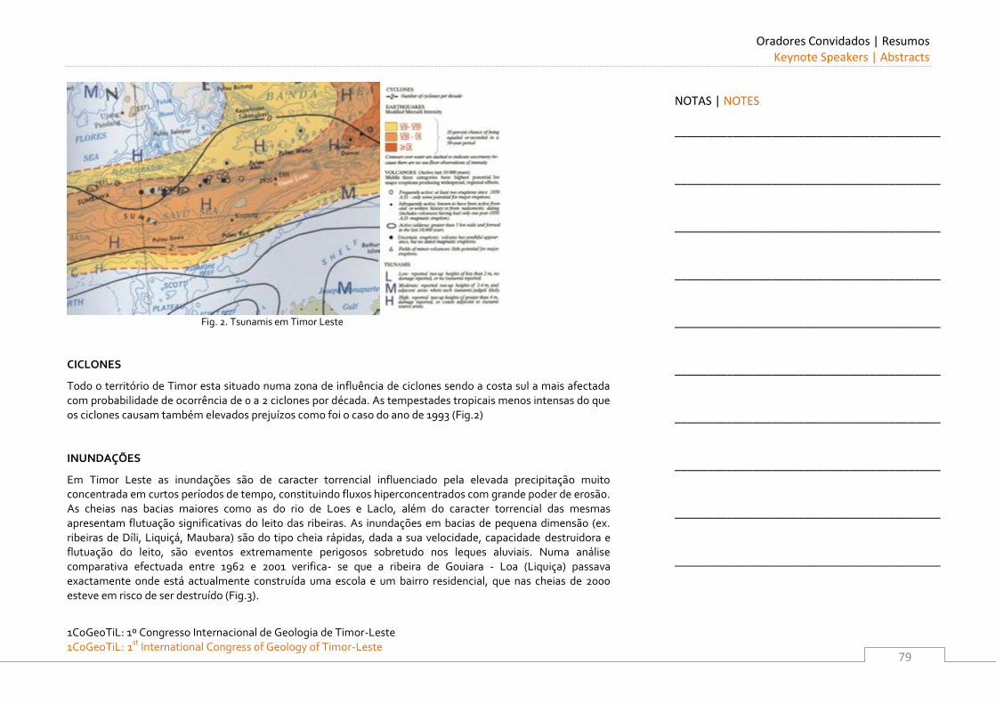
Oradores Convidados | Resumos Keynote Speakers | Abstracts
1CoGeoTiL: 1º Congresso Internacional de Geologia de Timor-Leste 1CoGeoTiL: 1st
International Congress of Geology of Timor-Leste
79
Fig. 2. Tsunamis em Timor Leste
CICLONES
Todo o território de Timor esta situado numa zona de influência de ciclones sendo a costa sul a mais afectada com probabilidade de ocorrência de 0 a 2 ciclones por década. As tempestades tropicais menos intensas do que os ciclones causam também elevados prejuízos como foi o caso do ano de 1993 (Fig.2) INUNDAÇÕES
Em Timor Leste as inundações são de caracter torrencial influenciado pela elevada precipitação muito concentrada em curtos períodos de tempo, constituindo fluxos hiperconcentrados com grande poder de erosão. As cheias nas bacias maiores como as do rio de Loes e Laclo, além do caracter torrencial das mesmas apresentam flutuação significativas do leito das ribeiras. As inundações em bacias de pequena dimensão (ex. ribeiras de Díli, Liquiçá, Maubara) são do tipo cheia rápidas, dada a sua velocidade, capacidade destruidora e flutuação do leito, são eventos extremamente perigosos sobretudo nos leques aluviais. Numa análise comparativa efectuada entre 1962 e 2001 verifica- se que a ribeira de Gouiara - Loa (Liquiça) passava exactamente onde está actualmente construída uma escola e um bairro residencial, que nas cheias de 2000 esteve em risco de ser destruído (Fig.3).
NOTAS | NOTES
_________________________________________
_________________________________________
_________________________________________
_________________________________________
_________________________________________
_________________________________________
_________________________________________
_________________________________________
_________________________________________
_________________________________________
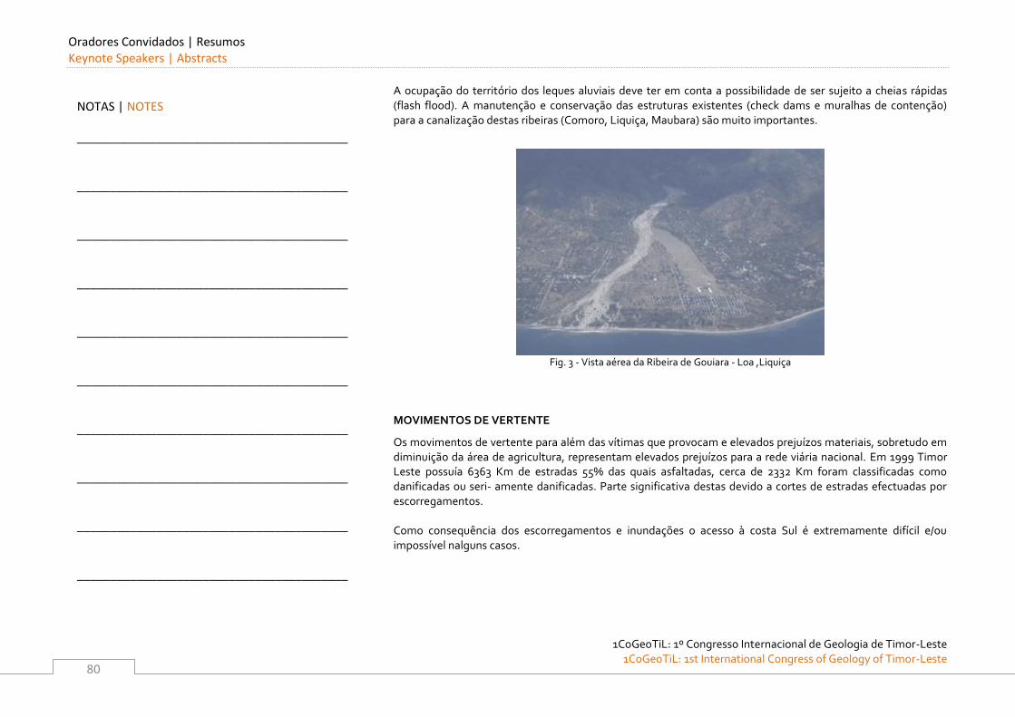
Oradores Convidados | Resumos Keynote Speakers | Abstracts
1CoGeoTiL: 1º Congresso Internacional de Geologia de Timor-Leste
1CoGeoTiL: 1st International Congress of Geology of Timor-Leste
80
A ocupação do território dos leques aluviais deve ter em conta a possibilidade de ser sujeito a cheias rápidas (flash flood). A manutenção e conservação das estruturas existentes (check dams e muralhas de contenção) para a canalização destas ribeiras (Comoro, Liquiça, Maubara) são muito importantes.
Fig. 3 - Vista aérea da Ribeira de Gouiara - Loa ,Liquiça
MOVIMENTOS DE VERTENTE
Os movimentos de vertente para além das vítimas que provocam e elevados prejuízos materiais, sobretudo em diminuição da área de agricultura, representam elevados prejuízos para a rede viária nacional. Em 1999 Timor Leste possuía 6363 Km de estradas 55% das quais asfaltadas, cerca de 2332 Km foram classificadas como danificadas ou seri- amente danificadas. Parte significativa destas devido a cortes de estradas efectuadas por escorregamentos. Como consequência dos escorregamentos e inundações o acesso à costa Sul é extremamente difícil e/ou impossível nalguns casos.
NOTAS | NOTES
_________________________________________
_________________________________________
_________________________________________
_________________________________________
_________________________________________
_________________________________________
_________________________________________
_________________________________________
_________________________________________
_________________________________________
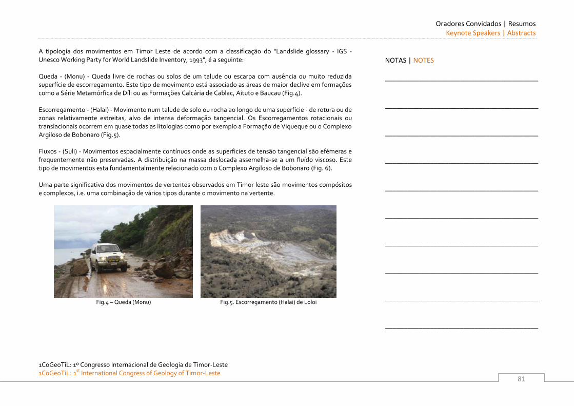
Oradores Convidados | Resumos Keynote Speakers | Abstracts
1CoGeoTiL: 1º Congresso Internacional de Geologia de Timor-Leste 1CoGeoTiL: 1st
International Congress of Geology of Timor-Leste
81
A tipologia dos movimentos em Timor Leste de acordo com a classificação do "Landslide glossary - IGS - Unesco Working Party for World Landslide Inventory, 1993", é a seguinte: Queda - (Monu) - Queda livre de rochas ou solos de um talude ou escarpa com ausência ou muito reduzida superfície de escorregamento. Este tipo de movimento está associado as áreas de maior declive em formações como a Série Metamórfica de Díli ou as Formações Calcária de Cablac, Aituto e Baucau (Fig.4). Escorregamento - (Halai) - Movimento num talude de solo ou rocha ao longo de uma superfície - de rotura ou de zonas relativamente estreitas, alvo de intensa deformação tangencial. Os Escorregamentos rotacionais ou translacionais ocorrem em quase todas as litologias como por exemplo a Formação de Viqueque ou o Complexo Argiloso de Bobonaro (Fig.5). Fluxos - (Suli) - Movimentos espacialmente contínuos onde as superficies de tensão tangencial são efémeras e frequentemente não preservadas. A distribuição na massa deslocada assemelha-se a um fluído viscoso. Este tipo de movimentos esta fundamentalmente relacionado com o Complexo Argiloso de Bobonaro (Fig. 6). Uma parte significativa dos movimentos de vertentes observados em Timor leste são movimentos compósitos e complexos, i.e. uma combinação de vários tipos durante o movimento na vertente.
Fig.4 – Queda (Monu) Fig.5. Escorregamento (Halai) de Loloi
NOTAS | NOTES
_________________________________________
_________________________________________
_________________________________________
_________________________________________
_________________________________________
_________________________________________
_________________________________________
_________________________________________
_________________________________________
_________________________________________
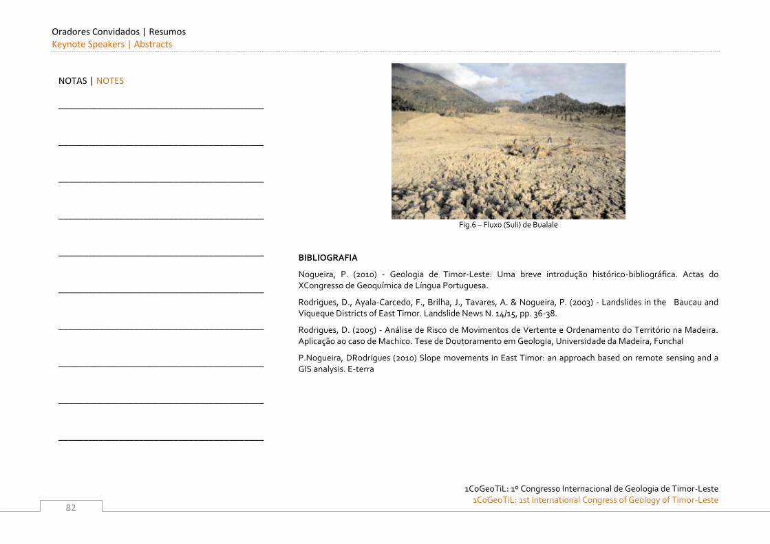
Oradores Convidados | Resumos Keynote Speakers | Abstracts
1CoGeoTiL: 1º Congresso Internacional de Geologia de Timor-Leste
1CoGeoTiL: 1st International Congress of Geology of Timor-Leste
82
Fig.6 – Fluxo (Suli) de Bualale
BIBLIOGRAFIA
Nogueira, P. (2010) - Geologia de Timor-Leste: Uma breve introdução histórico-bibliográfica. Actas do XCongresso de Geoquímica de Língua Portuguesa.
Rodrigues, D., Ayala-Carcedo, F., Brilha, J., Tavares, A. & Nogueira, P. (2003) - Landslides in the Baucau and Viqueque Districts of East Timor. Landslide News N. 14/15, pp. 36-38.
Rodrigues, D. (2005) - Análise de Risco de Movimentos de Vertente e Ordenamento do Território na Madeira. Aplicação ao caso de Machico. Tese de Doutoramento em Geologia, Universidade da Madeira, Funchal
P.Nogueira, DRodrigues (2010) Slope movements in East Timor: an approach based on remote sensing and a GIS analysis. E-terra
NOTAS | NOTES
_________________________________________
_________________________________________
_________________________________________
_________________________________________
_________________________________________
_________________________________________
_________________________________________
_________________________________________
_________________________________________
_________________________________________
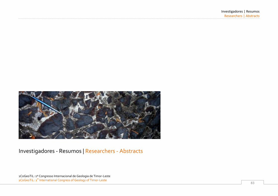
Investigadores | Resumos Researchers | Abstracts
1CoGeoTiL: 1º Congresso Internacional de Geologia de Timor-Leste 1CoGeoTiL: 1st
International Congress of Geology of Timor-Leste
83
Investigadores - Resumos | Researchers - Abstracts
Investigadores | Resumos Researchers | Abstracts
1CoGeoTiL: 1º Congresso Internacional de Geologia de Timor-Leste
1CoGeoTiL: 1st International Congress of Geology of Timor-Leste
84
Investigadores | Resumos Researchers| Abstracts
1CoGeoTiL: 1º Congresso Internacional de Geologia de Timor-Leste 1CoGeoTiL: 1st
International Congress of Geology of Timor-Leste
85
The Aileu Formation of Timor Leste
S.D. BOGER School of Earth Sciences, The University of Melbourne, Victoria, Australia. E-mail: [email protected] The Aileu Formation is exposed along the north coast of Timor Leste. It extends from the Indonesian border in
the west, underlies the capital Dili, and extends to Manatutu in the east. Covering approximately 20% of the
surface area of the island, it represents the largest single unit within the geology of Timor Leste. Although
representing, such a sizable chunk of the geology of Timor Leste, the origin of the Aileu Formation remains
enigmatic. Along its southern boundary the Aileu Formation is argued to be in stratigraphic contact with the
Maubissi Limestone, a fossiliferous Permian aged limestone–dominated formation of Australian continental
shelf affinity. By inference the Aileu Complex should thus also represent part of the Australian passive
continental margin, a view that is widely expressed in the published literature.
However, along the north coast, particularly at its eastern extreme, the Aileu Formation shares many
similarities with the metamorphic terranes commonly argued to the allochonous with respect to the Australian
passive origin. The Aileu Formation does for example preserve multiple stages of overprinting folding which
point to a complex deform history. The rocks reach moderately high metamorphic grades and metamorphism
appears to precede by 5 to 10 Myrs the inferred collision between the Australian margin and the Banda island
arc, the event that arguably should be responsible for the observed deformation. In addition the Aileu
Formation is structurally intercalated with subduction related peridotitic rocks considered to have formed
within Banda island arc and in the east is defined by volcanic lithologies more in keeping with an island arc
origin. Additionally the detrital zircons obtained from the Aileu Formation are dominated by young grains that
are not easily sourced from the Australian margin, but appear more likely of Asian origin.
This presentation explores the possibility that the seemingly contradictory evidence for both an Australian and
Asian origin for the Aileu Formation can be easily explained.
NOTAS | NOTES
_________________________________________
_________________________________________
_________________________________________
_________________________________________
_________________________________________
_________________________________________
_________________________________________
_________________________________________
_________________________________________
_________________________________________
Investigadores | Resumos Researchers | Abstracts
1CoGeoTiL: 1º Congresso Internacional de Geologia de Timor-Leste
1CoGeoTiL: 1st International Congress of Geology of Timor-Leste
86
The Hydrogeology of the Baucau Limestone of Timor-Leste
LINDSAY FURNESS Water Resources and Climate Adaptation Advisor, National Directorate of Water Resources, Ministry of Infrastructure, Democratic Republic of Timor-Leste. E-mail: [email protected]
The Baucau Limestone is a 100-500m thick, shallow marine/beach limestone, of calcirudites and calcarenites of
Pleistocene to Recent age1. The unit is principally composed of reefs and is highly karstified and terraced. The
formation is widespread in the eastern half of the country and is laterally equivalent to the Porous Limestone
(lacustrine) around Lake Surubeco, the Atauro (Island) Limestone, and in western Timor. In the type-locality
around Baucau, the formation is comprised of hard, vuggy, cavernous, massive, white coral-reef limestone,
which weathers to a pale grey colour2. The plateau is characterized by karst topography and dark reddish soil.
Around there, are coral reef limestones, calcirudites – massive poorly bedded conglomerates of reef debris,
calcarenites – sand grains of fragments of corals, bryozoans, Foraminifera, calcareous algae, molluscs and
echinoderms, and greywacke-pebbly sandstones.
The limestone has an unconformable base comprising former hills of the Viqueque Formation or Bobonaro
Scaly Clay. Limited drilling around Baucau has indicated a white to brown clay base.
The Baucau Limestone is a series of raised beaches that mark the stages of uplift of Timor during the
Pleistocene and Holocene due to epeirogenic uplift of Timor. Limestone is elevated up to 800m above mean sea
leel and uplift rates are indicated as 0.1-0.5mm/yr at Dili since 0.1Ma, 5-10mm/yr in west Timor since 2.2Ma and
1.4-1.9mm/yr at Kupang3. Terraces on Atauro Island have been geochronologically dated (Th230-U234) at
84,000, 105,000, and 120,000 years (uplift rates of 0.5mm/yr) and at Dili at 120,000 years (uplift of 0.03mm/yr) 4.
1 Wallace, et al. 2011. Hydrogeology of Timor-Leste. Geoscience Australia, Record 2011/XX.
2 Audley-Charles M.G., 1968. Geology of Portuguese Timor. geol. Soc. Lond. No. 4.
3 Y. Kaneko, et al. On-going orogeny in the outer-arc of the Timor-Tanimbar region, eastern Indonesia. Gondwana Research
11 (2007) 218-233. 4 Chappell & Veeh, 1978 Late Quaternary tectonic movements and sea level changes at Timor and Atauro Island. Geol. Soc.
America Bulletin 89, 356-368.
NOTAS | NOTES
_________________________________________
_________________________________________
_________________________________________
_________________________________________
_________________________________________
_________________________________________
_________________________________________
_________________________________________
_________________________________________
_________________________________________
Investigadores | Resumos Researchers| Abstracts
1CoGeoTiL: 1º Congresso Internacional de Geologia de Timor-Leste 1CoGeoTiL: 1st
International Congress of Geology of Timor-Leste
87
A cave at the eastern end of the island has paintings dated5 up to 40,000 years BP that is 40 m above current sea
level indicating minimum uplift at 1mm/yr.
There is a karst groundwater system in the Baucau Limestone that is recharged by rainfall over the plateau of
between 1,200mm and 1,700mm per year mostly falling in the wet season from November to April.
Groundwater flows through porous limestone, fractures and caves from the southwest high elevation of about
750m down to the periphery of the limestone where springs exist at lower elevations down to about 300m. The
water quality is fresh, although being a karst-style water is high in calcium-carbonate hardness. The water is
taken from large springs for town water, village water and sanitation and rice paddy.
In the southwest four caves were visited and found to have cave streams with flows up to 50 litres/sec. A dye-
tracing experiment was carried out using four fluorescent dyes (Fluorescein, Eosine, Sulforhodamine B,
Rhodamine WT) ,with a different colour introduced into each cave stream in high concentrations on the same
day. At weekly frequencies, samples were continuously taken at 11 monitoring sites, mostly prominent springs
in the area. The samplers comprised activated carbon granules (that absorb the dyes) in gauze bags that were
forwarded to a laboratory in the USA for spectrofluorophotometer6 measurement of trace amounts of the dyes.
The experiment successfully demonstrated a direct connection between two caves separated by 1km and with
the Uaililea Spring about 9km. The time of travel was about two weeks. Similarly there was a connection
between the Uaimatahun sinkhole and the Uainoi Spring 4km distant with a travel time of less than a week. A
fourth cave could not be connected with the 11 monitoring sites. No dye reached the Uailia Spring in the old
Baucau town over the five month monitoring period, suggesting that water comes there from around the
airport region and not from the caves in the southwest.
5 O’Connor et al. Faces of the ancestors revealed: discovery and dating of a Pleistocene-age petroglyph in Lene Hara Cave,
East Timor. Antiquity 84 (2010): 649-665. 6 Ozark Underground Laboratory, 2002. Ozark Underground Laboratory’s Groundwater Tracing Handbook.
NOTAS | NOTES
_________________________________________
_________________________________________
_________________________________________
_________________________________________
_________________________________________
_________________________________________
_________________________________________
_________________________________________
_________________________________________
_________________________________________
Investigadores | Resumos Researchers | Abstracts
1CoGeoTiL: 1º Congresso Internacional de Geologia de Timor-Leste
1CoGeoTiL: 1st International Congress of Geology of Timor-Leste
88
Monitoring of the elevation of water in the cave stream at Uaileaveri and the Uailia spring at Baucau has
revealed that near the recharge zone towards the southwest, there is a very rapid response (hours) in cave
stream level following rain storm events. This suggests very direct karst connections from the surface to the
cave. However, at the Uailia Spring monitoring over 7 months revealed the spring level varies very slowly and
the level of the spring (indicating spring flow) is not in sequence with the rainfall events of the wet season and
the lack of recharge in the dry season. This indicates that there is a two phase groundwater movement, a rapid
one in cave streams and a very slow movement in the primary porosity of the limestone. The conclusion has
recently been supported by dating the water7 showing a mean age of a few years in the cave area and several
thousand years at Uailea Spring in Baucau.
Time Domain Electromagnetic surveys were carried out8 at 11 sites along 3 lines at the Uaileaveri and
Uaileamata caves and the data were inverted to 3 layer models of dry limestone (15m) overlying saturated
limestone (10m) overlying highly conductive clay. It is proposed that an airborne EM survey be carried out over
the Baucau plateau to identify the unconformity with Viqueque Formation and Bobonaro Scaly Clay and the
fracture pattern to reveal cave systems with cave streams. The planned area to be flown by helicopter is 170km2
and about 800 line km of survey at 200m line separations. The maps generated in the survey will indicate
electromagnetic resistivity of the formation at various depths and will be used to guide future water well drilling
programs for agriculture, town water supply and village water and sanitation installations.
7 Wallace, L, Geoscience Australia L 2011 pers comm.
8 CSIRO 2011, Geophysical Studies in East Timor.
NOTAS | NOTES
_________________________________________
_________________________________________
_________________________________________
_________________________________________
_________________________________________
_________________________________________
_________________________________________
_________________________________________
_________________________________________
_________________________________________
Investigadores | Resumos Researchers| Abstracts
1CoGeoTiL: 1º Congresso Internacional de Geologia de Timor-Leste 1CoGeoTiL: 1st
International Congress of Geology of Timor-Leste
89
Evolution and Emergence of the Hinterland in the Active Banda Arc-Continent Collision:
Insights from the Coral Terraces and Metamorphic Rocks of Kisar, Indonesia
JONATHAN MAJOR 1*, RON HARRIS
1, HONG-WEI CHIANG 2, CAROLUS PRASETYADI
3, ARIF RIANTO 3, STEPHEN
T. NELSON 1, CHUAN-CHOU SHEN
2 1. Department of Geological Sciences, Brigham Young University, Provo, Utah, USA
2. High-precision Mass Spectrometry and Environment Change Laboratory (HISPEC), Department of Geosciences,
National Taiwan University, Taipei, Taiwan ROC
3. Universitas Pembangunan Nasional, Yogyakarta, Indonesia
* Present address: Bureau of Economic Geology, Jackson School of Geosciences, University of Texas at Austin,
Austin, Texas, USA. E-mail: [email protected]
Coral terrace surveys and U-series ages of coral yield a surface uplift rate of ~0.5 m/ka for Kisar Island located
near the NE coast of East Timor. Kisar is an emergent, roughly circular island located in the hinterland and near
the suture of the active Banda arc-continent collision. At the present day uplift rate rate, Kisar is estimated to
have first emerged from the ocean as recently as ~450 ka. Terrace surveying shows warping that follows a
pattern of east-west striking folds, which are along strike of thrust-related folds of similar wavelength imaged
by a seismic reflection profile just offshore. This deformation shows that the emergence of Kisar can be
attributed to closure of the forearc along the south-dipping Kisar Thrust. Active thrust faulting also causes
similar warping of coral terraces on the north coast of East Timor but has a different orientation.
Correlating terrace morphology to coral ages is resolved best by recognizing major terraces as mostly growth
terraces and minor terraces as mostly erosional into older growth terraces. All reliable and referable coral U-
series ages determined by MC-ICP-MS are marine isotope stage (MIS) 5e (118-128 ka), which apparently
encrusted the coast up to 60 m above present sea level. All unaltered coral samples are found below 6 m
elevation, but an unaltered tridacna (giant clam) shell in growth position at 95 m elevation yields a U-series age
of 195 ± 31 ka determined by alpha counting, which corresponds to MIS 7. This age agrees with the preferred
uplift model for the island.
NOTAS | NOTES
_________________________________________
_________________________________________
_________________________________________
_________________________________________
_________________________________________
_________________________________________
_________________________________________
_________________________________________
_________________________________________
_________________________________________
Investigadores | Resumos Researchers | Abstracts
1CoGeoTiL: 1º Congresso Internacional de Geologia de Timor-Leste
1CoGeoTiL: 1st International Congress of Geology of Timor-Leste
90
Three tridacna shell samples collected on Kisar and neighboring East Timor yield apparently referable, low-
resolution U-series age determinations by the alpha counting method when analyzing large samples. These
ages are independently tested by 14C, Electron Spin Resonance (ESR), and conventional ICP-MS analysis of
adjacent coral. These preliminary results are promising and indicate the need for further study.
Loose deposits of coral fragments found at elevations between 8 and 20 m yield ages of < 100 years and may
represent paleotsunami deposits from previously undocumented seismic activity in the region.
The metamorphic rocks of Kisar, Indonesia, which can now be correlated with the Aileu Metamorphic Complex
of East Timor by detrital zircon ages, record the breakup of a supercontinent, metamorphism from arc-
continent collision, and the growth and exhumation of a new orogenic belt. U-Pb analyses of detrital zircons
indicate a Permian to Late Jurassic age of the sedimentary sources and confirm an Australian provenance. The
protoliths of these rocks are mostly psammitic with minor basaltic and felsic igneous sources. Geochemical
analyses of mafic meta-igneous rocks show rift affinities that are likely related to rifting of Gondwana in the
Permian and eventual Jurassic breakup. The Aileu Complex is overlain by younger sedimentary rocks deposited
on the northern passive margin of Australia, which collided with the Banda Arc in latest Miocene time. This
collision caused metamorphism of the distal edge of the continental margin rocks. Metamorphic rocks of Kisar
record PT conditions of ~600°C at 5-7 kbar corresponding to depths around 20 km. These rocks were then
rapidly uplifted and exhumed.
The timing of metamorphism of the Aileu Complex and Kisar is poorly constrained by previous studies, of which
only a white mica cooling age of 5.36 +/- 0.05 Ma proved reliable. A prior apatite fission track study show that all
tracks are partially to completely annealed suggesting recent rapid cooling. This thermochronologic data has
been supplemented by new zircon U-Th/He ages that show cooling of Kisar to ~170° C by 4-5 Ma. Further
thermochronologic control by new Ar/Ar ages of biotite and amphibole is pending.
A domal geometry is expressed by the pinnacle shape of the island above the sea floor. Also, metamorphic
foliations on Kisar Island generally strike parallel to the coastline, which may indicate doming. The Kisar Thrust,
which is imaged in offshore seismic reflection data and evidenced by warping of the coral terraces, may lead to
diapirism into the hinge of the active thrust-related anticline. Thus, a combination of mechanisms is the best
explanation for the emergence of Kisar.
NOTAS | NOTES
_________________________________________
_________________________________________
_________________________________________
_________________________________________
_________________________________________
_________________________________________
_________________________________________
_________________________________________
_________________________________________
_________________________________________
Investigadores | Resumos Researchers| Abstracts
1CoGeoTiL: 1º Congresso Internacional de Geologia de Timor-Leste 1CoGeoTiL: 1st
International Congress of Geology of Timor-Leste
91
Earthquake and Tsunami History of Eastern Indonesia and the Timor Region as Revealed
by Dutch, Portuguese, and other Colonial Records
JONATHAN MAJOR *, RON HARRIS, JAMIE ROBINSON, NATE BAIRD, YUNG-CHUN LIU Department of Geological Sciences, Brigham Young University, Provo, Utah, USA
* Present address: Bureau of Economic Geology, Jackson School of Geosciences, University of Texas at Austin,
Austin, Texas, USA. E-mail: [email protected]
A new translation into English of Arthur Wichmann’s “Earthquakes of the Indian Archipelago” has made
available a valuable record of the earthquake and tsunami history of the Indonesian region. The catalog includes
30 significant earthquakes and 29 tsunamis between 1629 and 1877 in eastern Indonesia. At least 6 significant
earthquake and/or tsunami events have affected the Timor region starting in 1648. The Sunda Arc along
Sumatra has been the subject of intense study since the devastating event in 2004 and subsequent events, but
other regions of potential earthquakes and tsunamis in Indonesia are still poorly understood. The overall hazard
likely underestimated due to this lack of data and has not yet received adequate study. The events recorded in
Wichmann’s catalog indicate that eastern Indonesia and the Timor region has been overlooked. Population
growth over the past century has increased the hazard substantially.
Tsunami modeling is now being used to investigate the source region of a few of these events. These studies are
being prepared for publication along with a translation of the catalog. These publications will make this valuable
data available to the scientific community, lay a framework for future study, and spark further interest in the
region. We seek further collaboration with local and international scientists to help the millions now living in
harm’s way. For example, other local records may exist from early colonial days and should be investigated.
NOTAS | NOTES
_________________________________________
_________________________________________
_________________________________________
_________________________________________
_________________________________________
_________________________________________
_________________________________________
_________________________________________
_________________________________________
_________________________________________
Investigadores | Resumos Researchers | Abstracts
1CoGeoTiL: 1º Congresso Internacional de Geologia de Timor-Leste
1CoGeoTiL: 1st International Congress of Geology of Timor-Leste
92
Earth-Science Education: From all over the World to East-Timor
LUIS MARQUES 1, DORINDA REBELO
2, A. SOARES DE ANDRADE 3, JORGE BONITO
4 1. University of Aveiro, Portugal. E-mail: [email protected]
2. Secondary School of Estarreja. Portugal. E-mail: [email protected]
3. University of Aveiro, Portugal. E-mail: [email protected]
4. University of Evora, Portugal. E-mail: [email protected]
Members of the Group responsible for the designing of the secondary school geology curriculum.
Introduction
Earth Science education (ESE) emerges as a relatively new research area and there is an unquestioned need for
improving students´ abilities on that field (American Geological Institute, 2008), taking into account that it is
important for students’ everyday lives and thus, relevant for scientific literacy. So, the inclusion of a section
concerned with this issue, was a very wise decision of the 1st Geological Congress at East-Timor Organising
Committee, revealing an up to date vision about education for the XXI century.
The paper will be divided in four sections:
* Science Education - meaning, epistemology and rationale;
* Earth- science education all over the World in the context of Science Education;
* Earth- science education in East-Timor secondary school curriculum;
* Earth-science education and challenges for the future.
NOTAS | NOTES
_________________________________________
_________________________________________
_________________________________________
_________________________________________
_________________________________________
_________________________________________
_________________________________________
_________________________________________
_________________________________________
_________________________________________
Investigadores | Resumos Researchers| Abstracts
1CoGeoTiL: 1º Congresso Internacional de Geologia de Timor-Leste 1CoGeoTiL: 1st
International Congress of Geology of Timor-Leste
93
Science Education - meaning, epistemology and rationale
Science is an activity that all children from all cultural and ethnic backgrounds should participate in and “own”.
Moreover, the teaching of science through practical activities involving students is a source of enthusiasm and
motivation. If teachers do not see science as a worldwide and humanistic phenomenon, they will continue to
see the science and the technology in a way reinforcing inaccurate stereotypes (Dennick, 2002).Therefore,
science contents are relevant despite not exclusives. Scientific processes and the procedures concerned with
appropriate ways of learning are also under discussion. Science Education (SE) is the field concerned with
sharing science contents and process with individuals not traditionally belonging to the scientific community.
The standards for SE provide expectations for the development of students’ understanding through the entire
compulsory education. The traditional subjects included in the standards are physical, life, Earth, and space
sciences.
About the science approach, research has been revealed that students’ and teachers’ perspectives about the
nature of scientific knowledge influence the way how they learn and teach, respectively (Nadelsen and
Viskupics, 2010; Praia and Cachapuz,1999). Learning subject content is dependent of the epistemologies used
in the classroom and so, educational events can be viewed as practices with their own epistemologies. Through
the last three decades there has been a shift from “content” to “process” or from “science as knowledge” to
“science as a way of finding out” (Amos and Boohan, 2002).
Research also suggests a set of common rationales for SE: (a) the utilitarian - an understanding of science is
crucial mainly to anyone living in a knowledge society; (b) the economic - connection between the level of
public scientific background and the nation’s economic health; (c) the democratic- decisions have to be made
about disposal of waste, energy policy, minimised effects of mineral exploitation, loss of natural beauty,…; (d)
the cultural - science should be celebrate as cultural domain (Millar, 2002).
Synthesis of this section. The authors emphasize three guidelines rooted on educational research for the
designing of science curriculum: science contents, methods of enquiry used in science and science as a social
enterprise.
NOTAS | NOTES
_________________________________________
_________________________________________
_________________________________________
_________________________________________
_________________________________________
_________________________________________
_________________________________________
_________________________________________
_________________________________________
_________________________________________
Investigadores | Resumos Researchers | Abstracts
1CoGeoTiL: 1º Congresso Internacional de Geologia de Timor-Leste
1CoGeoTiL: 1st International Congress of Geology of Timor-Leste
94
Earth-sciences education in the context of SE
In the following of both the reflection and guidelines referred to above, a set of assumptions, for ESE emerges:
. the Earth works as system with humans as a subsystem contrasting with the idea of distinctness of man
from the natural world (Mayer, 2003);
. the understanding of the Earth must be holistic across both space and time (Frodeman, 2003);
. the Earth seen as a system often with the various system cycles as components of the organizing
framework (Orion 2003);
. the core concepts fundamental to reasoning and inquiring in the Earth sciences include scale - deep time
and space, energy - gravitational, thermal, tidal and solar sources, matter transformation - rock cycle (Duschl,
2006);
. the Earth-science curriculum should be about “common things” in both the natural and man-made world
which have relevance at the personal, family, local, regional, national and global levels (Thompson, 2001).
These “common things” and some of the “core concepts”, for example, help to understand that Earth-science is
at one and the same time concrete and abstract to the learners. The flowing streams, the outcrops with strata,
the soil we dig in, the mineral and rocks picked up in the field all contribute to the familiar phenomenon of our
sense perception view of the Earth and its processes. The continental drift or plate tectonics, at least their
mechanisms, the age and origin of the Earth, even the geomorphologic evolution, are counter intuitive in real
time.
As far as the earth science curriculum is concerned, these concrete and abstract views should be included on it -
focusing, on the one hand on developing an understanding of geological processes and events at specific places
and times and, on the other hand on guiding principles of an holistic perspective of the planet, enabling a
systems analysis of the Earth.
In this context, recalling “science as a way of finding out”, one is faced with two rationales for the importance of
the Earth science in the curriculum:
. contribution for understanding the way how the Earth works;
. promoting, through an interdisciplinary approach, the habitability and sustainability of the Earth towards the
definition of policies of management concerning land use and land planning. To achieve this, sustainability
education must be truly interdisciplinary involving physics, chemistry, biology, even politics, economics or
philosophy.
NOTAS | NOTES
_________________________________________
_________________________________________
_________________________________________
_________________________________________
_________________________________________
_________________________________________
_________________________________________
_________________________________________
_________________________________________
_________________________________________
Investigadores | Resumos Researchers| Abstracts
1CoGeoTiL: 1º Congresso Internacional de Geologia de Timor-Leste 1CoGeoTiL: 1st
International Congress of Geology of Timor-Leste
95
Despite ESE could be seen as a very young research area, as it was already stressed, a tremendous amount of
work has been done since early 1980s of the 20th century. In the context of SE research, very strong evidences
have been revealed that students enter in their science classes with ideas about the natural world that do not
correspond with accepted scientific findings. Topics such as, for example, the Earth and the solar system, origin
of the Earth, volcanoes, earthquakes, geological time, continental drift, plate tectonics have been under
scrutiny (Bonito et. al., 2011; Dahl, Andersen and Libarkin, 2005; Marques and Thompson, 1997). The diagnosis
of these preconceptions may be seen as a crucial, initial step in the process of teacher facilitated conceptual
change at all grade levels. To develop conceptual change, educators may employ new ways of constructivist
teaching based on assumptions of cognitive learning (Bonito, 2008). Emphasis on inquiry processes in the
curriculum promoting problem solving (Soares de Andrade, 2001) seem to be a powerful procedure to develop
students’ competences towards the growth of citizenship.
The validation of the results obtained related to this new research area is mainly carried out, as usually at the
scientific community, in SE scientific meetings. Nevertheless, the authors think that it is fair to underlie,
particularly in the context of this paper, the role played by the International Geoscience Education Organization
(IGEO), affiliated to and sponsored by IUGS. The main goal of the organization is to promote ESE
internationally, at all levels. The last IGEO Conference - GeoSciEdVI - took place in 2010, at the University of
Witwatersrand, at Johannesburg. The several areas of the Conference are here indicated, for giving a flavour
related to what has been done in ESE research so far: best practice in ESE; ESE in the real world; teaching
difficult and/or controversial geoscience topics; ESE in informal settings; using computers and multimedia to
teach about geosciences, geoheritage, different social economic and political contexts;
collecting/analysing/modelling geoscience data; using Earth sciences Olympiads as a tool to promote ESE.
Synthesis of this section. ESE is now a novel research area concerned with an holistic view of the Earth, using SE
methodologies and contributing with suggestions for a designed curriculum which is supposed to reach an
accurate view about the way the Planet works and, therefore, about its sustainability.
NOTAS | NOTES
_________________________________________
_________________________________________
_________________________________________
_________________________________________
_________________________________________
_________________________________________
_________________________________________
_________________________________________
_________________________________________
_________________________________________
Investigadores | Resumos Researchers | Abstracts
1CoGeoTiL: 1º Congresso Internacional de Geologia de Timor-Leste
1CoGeoTiL: 1st International Congress of Geology of Timor-Leste
96
Earth-science Education in East-Timor secondary school curriculum
Politicians with high responsibility in East Timor have been arguing, across time, that Education is on the top of
their priorities. The Education National Plan 2007 and, particularly, the plan Timor-Leste Plano Estratégico de
Desenvolvimento 2011-2030. underline that high educational standards are needed to contribute to the growth
of the country. This is the political context in which the *Reestruturação Curricular do Ensino Secundário Geral
em Timor-Leste (2011) was requested by the Minister of Education of East-Timor to the Calouste Gulbenkian
Foundation. The University of Aveiro, through a large group of experts coordinated by Professor Isabel Martins,
has the scientific responsibility for the designing of this ambitious programme. Programmes, textbooks and
teachers´ guides for all disciplines are also being written by the group of specialists. Considering the nature of
this paper, the authors find important to quote from that new curriculum:
. one of the principles – to use guidelines from the Decade of Education for Sustainable Development,
United Nations Literacy Decade and Millenium Development Goals (p. 13);
. one of the objectives - to promote the role of the multidisciplinary scientific knowledge towards the
understanding of local, national and global problems (p. 16).
The figure below shows (in strong articulation with the previous sections) the three main sequential dimensions
of the Geology curriculum for the triennial (10th-12thlevel) and under a common organizer Geology of East-
Timor and sustainability: past, present and future.
* Participation of the Instituto Português de Apoio ao Desenvolvimento, Fundação Calouste Gulbenkian,
Universidade de Aveiro and Ministério da Educação de Timor-Leste. Financial suport of Fundo da Língua
Portuguesa.
NOTAS | NOTES
_________________________________________
_________________________________________
_________________________________________
_________________________________________
_________________________________________
_________________________________________
_________________________________________
_________________________________________
_________________________________________
_________________________________________
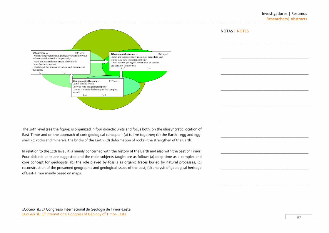
Investigadores | Resumos Researchers| Abstracts
1CoGeoTiL: 1º Congresso Internacional de Geologia de Timor-Leste 1CoGeoTiL: 1st
International Congress of Geology of Timor-Leste
97
The 10th level (see the figure) is organized in four didactic units and focus both, on the idiosyncratic location of
East-Timor and on the approach of core geological concepts - (a) to live together; (b) the Earth - egg and egg-
shell; (c) rocks and minerals: the bricks of the Earth; (d) deformation of rocks - the strengthen of the Earth.
In relation to the 11th level, it is mainly concerned with the history of the Earth and also with the past of Timor.
Four didactic units are suggested and the main subjects taught are as follow: (a) deep time as a complex and
core concept for geologists; (b) the role played by fossils as organic traces buried by natural processes; (c)
reconstruction of the presumed geographic and geological issues of the past; (d) analysis of geological heritage
of East-Timor mainly based on maps.
NOTAS | NOTES
_________________________________________
_________________________________________
_________________________________________
_________________________________________
_________________________________________
_________________________________________
_________________________________________
_________________________________________
_________________________________________
_________________________________________
Investigadores | Resumos Researchers | Abstracts
1CoGeoTiL: 1º Congresso Internacional de Geologia de Timor-Leste
1CoGeoTiL: 1st International Congress of Geology of Timor-Leste
98
Regarding the 12th level, an attempt to face the students with several geological issues, mainly related to East-
Timor itself will be done. Three units are put forward: (a) geology and society: hazards and resources; (b)
geological hazards stressing those which can occur in the country; (c) geological resources, emphasizing oil
origin, storage, usefulness and sustainable exploitation .
Synthesis of this section. We should emphasize that, as it is quite common, the discipline begins by teaching
learners to broad concepts and fundamentals and then, apply for understanding either the way the earth works
or a few geologic aspects of this country. In addition, it is the authors’ expectation that the curricular topics and
the approached methodologies can help the articulation between secondary and tertiary education.
Earth-science education and challenges for the future.
Interest in a specific area of science is highly correlated with the perceived benefit. We expect that Geology
topics, increase students’ interests in probing the secrecies of nature and motivate their concerns about
environmental problems - local and around the world - reinforcing a citizenship attitude. This achievement
would be facilitated through an approach well articulated with other scientific areas in a holistic way i.e. in a
Gaia perspective (Lovelock, 2007). Another contribution of the referred to above topics is the development of
students’ competences, such as critical and independent thinking, to pursuing their courses at tertiary
education.
No doubt that all of the above requires extensive investment in science teacher education, both in pre-service
and in-service. Taking into account that teachers deal with young people from all walks of life on a daily basis
for many years, they play a crucial role in the students’ development of competences planning science
approach, i.e. earth science, in a social, moral, spiritual and cultural context. The lack of experience of earth
science teaching at East Timor science secondary curriculum reinforces the challenge of teachers’ education for
this knowledge area. Geology contents and pedagogical content knowledge are teachers’ crucial achievements.
NOTAS | NOTES
_________________________________________
_________________________________________
_________________________________________
_________________________________________
_________________________________________
_________________________________________
_________________________________________
_________________________________________
_________________________________________
_________________________________________

Investigadores | Resumos Researchers| Abstracts
1CoGeoTiL: 1º Congresso Internacional de Geologia de Timor-Leste 1CoGeoTiL: 1st
International Congress of Geology of Timor-Leste
99
References
American Geological Institute (2008). Critical needs for the twenty first century: the role of geosciences.
Alexandria, VA, American Geological Institute. 18.
Amos, S. and Boohan, R. (2002). Teaching Science in Secondary Schools. London. Routledge Falmer.
Bonito, J. (2008). Perpectivas actuais sobre o ensino das ciências: clarificação de caminhos. Terrae Didatica,
4(1), 28-42.
Bonito, J., Medina, J., Morgado, M., Rebelo, D., Monteiro, G., Martins, L. and Marques, L. (2011). La naturaleza
del tiempo y su complejidad: el caso del tiempo geológico – implicaciones educativas. DYNA, 169(78), 247-257.
Dahl, J., Andersen, S.W. and Libarkin, J. C. (2005).Digging into Earth science: alternative conceptions held by K-
12 teachers. Journal of Geoscience Education, 682), 65-68.
Duschl, A. and Herbert, B. (2006). Immersion Units in Earth Sciences. Não publicado.
Dennick, R. (2002). Analysing multi-cultural and anti-racist science education.. In Amos, S. & Boohan, R. (Eds.)
Teaching Science in Secondary Schools. 102-112.
Frodeman, R. (2003). Geo-Logic. Breaking Ground Between Philosophy and the Earth Sciences. New York.
State University of New York Press.
Lovelock, J. (2007). A Vingança de Gaia. Lisboa. Ed. Gradiva.
Marques, L. and Thompson, D.(1997). Misconceptions and conceptual change concerning continental drift and
platetectonics among Portuguese students aged 16-17. Research in Science and Technology Education, 15, 195-
222.
Mayer, V. (2003). Implementing Global Science Literacy. Ohio. Ohio State University.
Millar, R. (2002). Towards a science curriculum for public understanding. In Amos, S. & Boohan, R. (Eds.)
Teaching Science in Secondary Schools. 113-128.
NOTAS | NOTES
_________________________________________
_________________________________________
_________________________________________
_________________________________________
_________________________________________
_________________________________________
_________________________________________
_________________________________________
_________________________________________
_________________________________________
Investigadores | Resumos Researchers | Abstracts
1CoGeoTiL: 1º Congresso Internacional de Geologia de Timor-Leste
1CoGeoTiL: 1st International Congress of Geology of Timor-Leste
100
Nadelsen, L. S. and Viskupics, K. (2010). Perceptions of the nature of science by geoscience students
experiencing two different courses of study. Journal of Geoscience Education, 58(5). 275-285.
Praia, J.e Cachapuz, A. (1999). Práticas de professores de ciências: da sua análise à luz de novas orientações
epistemológico-didácticas à incidência na formação de professores. In V. Trindade (Ed.) Metodologias do
Ensino das CIências. Évora. Universidade de Évora
Orion, N. (2003). The outdoor as a central learning environment in the global science literacy framework: from
theory to practice. In Mayer, V. (Ed.). Implementing Global Science Literacy. Ohio. Ohio State University. 53-
66.
Reestruturação Curricular do Ensino Secundário Geral em Timor-Leste: Plano Curricular do Ensino Secundário
Geral (2011). Ministério da Educação de Timor-Leste.
Soares de Andrade, A, (2001). Problem-solving in earth-science. In Marques, L e Praia, J. (Orgs). Geoscience in
the Secondary School Curriculum. Aveiro. Universidade de Aveiro. 285-298
Thompson, D. (2001). Towards an earth-environmental science education for all aged 4-16. In Marques, L e
Praia, J. (Orgs). Geoscience in the Secondary School Curriculum. Aveiro. Universidade de Aveiro. 301-331.
Wickman, P. (2004). The practical epistemologies of the classroom: a study of laboratory work. Science
Education, 88(3), 325-344.
NOTAS | NOTES
_________________________________________
_________________________________________
_________________________________________
_________________________________________
_________________________________________
_________________________________________
_________________________________________
_________________________________________
_________________________________________
_________________________________________
Investigadores | Resumos Researchers| Abstracts
1CoGeoTiL: 1º Congresso Internacional de Geologia de Timor-Leste 1CoGeoTiL: 1st
International Congress of Geology of Timor-Leste
101
Análise de Riscos Geomorfológicos na Região de Bobonaro, Timor-Leste
BENJAMIM DE OLIVEIRA HOPFFER RÊGO SILVEIRA MARTINS Universidade do Algarve, Faculdade de Ciências e Tecnologia. E-mail: [email protected]
Timor-Leste actualmente é considerado como um exemplo extremo de deficiências de capacidade de adaptação às alterações climáticas. O clima é um dos factores influentes na frequência e na magnitude dos movimentos de vertentes. Os movimentos de vertente representam um risco significativo para a vida, subsistência, propriedade, infra-estruturas e recursos em muitas partes do mundo. A região de Bobonaro situa-se numa área onde aflora a Formação Bobonaro Scaly Clay, essencialmente constituída por argilas mal consolidadas e uma mistura de litoclastos muito heterogénea e heterométrica onde se incluem blocos de grandes dimensões. A paisagem correspondente a esta formação geológica regista marcas de importantes movimentos de vertente, resultado da interacção entre as rochas argilosas e a precipitação, como parte do processo dinâmico e estrutural na modelação da superfície terrestre. A compreensão da Geomorfologia de uma dada região é factor de sucesso em várias actividades humanas, como são exemplos a pesquisa de recursos minerais e o ordenamento do território. A gestão dos recursos naturais só tem sentido num quadro geomorfológico bem conhecido. A ocupação humana da superfície do planeta conduziu ao conceito de risco geomorfológico, envolvendo todos os fenómenos de superfície capazes de perturbar, de modo mais ou menos dramático, a vida e as actividades das populações. É nosso objectivo que o presente trabalho, possa contribuir para a caracterização da geomorfologia da região de Bobonaro face aos desastres naturais, com especial atenção, para a identificação dos factores geomorfológicos e ambientais que contribuem para a ocorrência de movimentos de vertente. Como resultado do presente estudo, em primeiro lugar, serão apresentados mapas onde são identificadas as áreas de susceptibilidade e de risco à ocorrência de movimentos de vertente, de utilidade para o planeamento e o ordenamento da região de Bobonaro, em segundo lugar, será feita a caracterização dos tipos de movimentos de vertente e por último serão sugeridas medidas de ordenamento territorial com base nos resultados do presente trabalho. Dada a limitação dos dados disponíveis, optou-se por uma abordagem semi-quantitativa para a avaliação de risco de movimentos de vertente, que é considerada útil nas seguintes condições: (i) como um processo inicial de identificação de perigos e riscos; (ii) quando o nível de risco (pré-assumido) não justifique o tempo e o esforço; (iii) ou quando a possibilidade de obtenção de dados numéricos é limitada.
NOTAS | NOTES
_________________________________________
_________________________________________
_________________________________________
_________________________________________
_________________________________________
_________________________________________
_________________________________________
_________________________________________
_________________________________________
_________________________________________
Investigadores | Resumos Researchers | Abstracts
1CoGeoTiL: 1º Congresso Internacional de Geologia de Timor-Leste
1CoGeoTiL: 1st International Congress of Geology of Timor-Leste
102
Para a implementação do modelo semi-quantitativo, recorreu-se à utilização do módulo Spatial Analysis Tools do software ArcGIS 9.3 com base na avaliação espacial multi-critério, ou seja, SMCE (Spatial Multi Criteria Evaluation) em ambiente de SIG. O fundamento teórico para a avaliação multi-critério baseia-se na técnica de suporte à decisão AHP (Analysis Hierarchy Process) que permite determinar um conjunto óptimo de pesos dos factores que condicionam os movimentos de vertente utilizados para a combinação dos diferentes mapas. As áreas que se localizam nas formações de Wailuli e Bobonaro Scaly Clay revelam ser as de susceptibilidade “muito elevada” a ocorrência de movimentos de vertente porque expõem essencialmente de xistos argilosos e argilas com esmectite e com declives superiores a 12º. Palavra-chave: Bobonaro, Geomorfologia, Movimentos de Vertente, Susceptibilidade, Vulnerabilidade, Risco, SIG (Sistemas de Informação Geográfica), SMCE (Spatial Multi Criteria Evaluation), AHP (Analysis Hierarchy Process), Gestão do território
NOTAS | NOTES
_________________________________________
_________________________________________
_________________________________________
_________________________________________
_________________________________________
_________________________________________
_________________________________________
_________________________________________
_________________________________________
_________________________________________
Investigadores | Resumos Researchers| Abstracts
1CoGeoTiL: 1º Congresso Internacional de Geologia de Timor-Leste 1CoGeoTiL: 1st
International Congress of Geology of Timor-Leste
103
Detrital zircon provenance and insights into palaeogeographic reconstructions of the
Banda Arc
INGA SEVASTJANOVA 1, ROBERT HALL AND SEBASTIAN ZIMMERMANN
1. SE Asia Research Group, Royal Holloway University of London. E-mail: [email protected]
The Banda Arc is composed of an inner volcanic arc, outer arc islands and a trough parallel to the Australian
continental margin which curves in horse-shoe shape around the Banda Sea. The region has significant
hydrocarbon potential and is the focus of active scientific debate. Most authors agree that in the south, in
Timor, there was collision between a volcanic arc and the Australian continental margin. Fragments of
continental crust in the Banda arc are known to be of Australian origin, but their ages of rifting and collision
remain controversial.
Detailed detrital zircon provenance studies can contribute to resolving some of the arguments. For example,
Charlton (2001) suggested that the Banda Arc was situated close to the Malay Peninsula in the Late Palaeozoic-
Early Mesozoic. Based on this model, some authors have suggested that detrital Permian-Triassic zircons that
are found in Timor were derived from the Malay Peninsula. However, the existence of an alternative Permian-
Triassic zircon source would have different consequences for models of Banda Arc development. For example,
Hall et al. (2009) and Spakman and Hall (2011) proposed a model in which the Sula Spur was fragmented during
subduction rollback. In this scenario detrital zircons in the Banda Arc were derived from the Sula Spur and not
from the Sundaland crust of the Malay Peninsula.
We aim to provide a detailed provenance fingerprint of zircons in SE Asia, using various techniques. In order to
identify zircon populations diagnostic of detritus derived from specific areas in SE Asia, existing analyses are
being systematically compiled into a regional zircon age database. New zircon U-Pb ages and Hf isotope
analyses are being acquired from many areas where there are no data.
NOTAS | NOTES
_________________________________________
_________________________________________
_________________________________________
_________________________________________
_________________________________________
_________________________________________
_________________________________________
_________________________________________
_________________________________________
_________________________________________
Investigadores | Resumos Researchers | Abstracts
1CoGeoTiL: 1º Congresso Internacional de Geologia de Timor-Leste
1CoGeoTiL: 1st International Congress of Geology of Timor-Leste
104
Our results so far show that Paleoproterozoic, Mesoproterozoic, Neoproterozoic-Cambrian, Ordovician-
Silurian, Devonian and Permian-Triassic detrital zircon U-Pb age populations are common in the Banda Arc. The
absence of zircons older than the Neoarchean (>2.5 Ga) and abundant Paleo- to Mesoproterozoic (c.a. 1.9 to 1.3
Ga) populations suggest that continental fragments now beneath the Banda Arc originated from northern and
northwestern Australia. Silurian-Devonian detrital zircons are abundant in the Banda Arc but are rare in the
Malay Peninsula. This favours provenance from the Sula Spur and the Bird’s Head in the New Guinea and not
from the Malay Peninsula. Recent provenance studies show that Permian-Triassic zircons are also abundant in
the Bird’s Head (I. Gunawan, pers. comm. 2011) and these are most likely derived from nearby acid igneous
rocks (e.g. Pieters et al. 1983) and the Banggai-Sula Islands (e.g. Pigram et al. 1985). These eastern Indonesian
sources are also likely to have shed Permian-Triassic zircons to the other parts of the Banda Arc.
In the Malay Peninsula, crust-derived signatures are diagnostic of Triassic zircons from the Sibumasu Block,
whereas mixed crust- and mantle-derived signatures of similar age zircons are diagnostic of the East Malaya
Block (Sevastjanova et al., 2011). Comparison of new Permian-Triassic zircon Hf isotope data from Seram with
those from the Malay Peninsula, shows that crust-derived Triassic zircons that are abundant on the Sibumasu
are not common in Seram.
A systematic approach and detailed knowledge of zircon ages diagnostic of different source areas in SE Asia are
critical for provenance and palaeogeographic reconstructions in the Banda Arc.
References
Charlton, T.R., 2001. Permo-Triassic evolution of Gondwanan eastern Indonesia, and the final Mesozoic
separation of SE Asia from Australia. Journal of Asian Earth Sciences 19(5), 595-617.
Hall, R., Clements, B., Smyth, H.R., 2009. Sundaland: Basement character, structure and plate tectonic
development. Proceedings Indonesian Petroleum Association 33rd Annual Convention, IPA09-G-134 1-27.
Pieters, P.E., Sanyoto, P., 1993. Geology of the Pontianak/Nangataman Sheet area, Kalimantan: 1:250,000.
Geological Research and Development Centre, Bandung, Indonesia.
NOTAS | NOTES
_________________________________________
_________________________________________
_________________________________________
_________________________________________
_________________________________________
_________________________________________
_________________________________________
_________________________________________
_________________________________________
_________________________________________
Investigadores | Resumos Researchers| Abstracts
1CoGeoTiL: 1º Congresso Internacional de Geologia de Timor-Leste 1CoGeoTiL: 1st
International Congress of Geology of Timor-Leste
105
Pigram, C.J., Panggabean, H., 1984. Rifting of the northern margin of the Australian continent and the origin of
some microcontinents in eastern Indonesia. Tectonophysics 107, 331-353.
Sevastjanova, I. et al., 2011. Granitic magmatism, basement ages, and provenance indicators in the Malay
Peninsula: Insights from detrital zircon U-Pb and Hf-isotope data. Gondwana Research 19(4), 1024-1039.
Spakman, W., Hall, R., 2010. Surface deformation and slab-mantle interaction during Banda Arc subduction
rollback. Nature Geoscience 3, 562-566.
NOTAS | NOTES
_________________________________________
_________________________________________
_________________________________________
_________________________________________
_________________________________________
_________________________________________
_________________________________________
_________________________________________
_________________________________________
_________________________________________
Investigadores | Resumos Researchers | Abstracts
1CoGeoTiL: 1º Congresso Internacional de Geologia de Timor-Leste
1CoGeoTiL: 1st International Congress of Geology of Timor-Leste
106
Deep Sea Minerals in the Pacific: Status, Challenges and Opportunities
AKUILA TAWAKE Secretariat of the Pacific Community - SOPAC Deep Sea Minerals Project. E-mail: [email protected] Deep sea research and exploration in the Pacific ocean over the past 40 years, including the extensive regional 1985-2005 Japan-SOPAC cooperative study programme, has led to the discovery of a number of seabed mineral deposits within the Exclusive Economic Zone (EEZ) of many Pacific Island countries. Three different types of mineral deposits have been observed on the deep seabed: • cobalt rich crust - formed on hard-rock seamounts, 400-4000 metres under water; • seafloor massive sulphides ('SMS') - formed at hydrothermal vents, along seabed ridges; and • manganese nodules - formed on sediment-covered abyssal plains at 4000-6500 metres water depth.
The exploration activities undertaken to date suggest that these deposits may obtain significant quantities and grades of valuable metals. The UN Convention on the Law of the Sea gives a coastal State sovereign rights over mineral deposits in its EEZ. Mining of deep sea minerals may therefore present a new industry and opportunity for revenue for Pacific Island states. Any offshore mining operation has to compete with terrestrial mining, and its viability hinge upon world demand, commodity prices, and technological development. Recent studies have indicated that mining of SMS deposits will commence within the next few years, and may spread to manganese nodules in the next 5-10 years. However the detail of the extent and nature of the deposits, whether they can be successfully brought to the surface, and whether it can be done profitably in a way that is also responsible and lawful, particularly with regards the environmental impact, are all matters yet to be determined. International law requires States to take all appropriate steps to ensure that deep sea mineral exploration and exploitation activities within their jurisdiction or control are appropriately managed, in accordance with international standards. These include obligations to: protect and preserve marine resources and marine scientific research, conserve living marine habitats and rare or fragile ecosystems, and monitor and minimise the risks or effects of pollution. Ensuring these standards are met requires the adoption of national laws and administrative measures. If States do not fulfil these obligations they will be liable for any damage occurring as a result.
NOTAS | NOTES
_________________________________________
_________________________________________
_________________________________________
_________________________________________
_________________________________________
_________________________________________
_________________________________________
_________________________________________
_________________________________________
_________________________________________
Investigadores | Resumos Researchers | Abstracts
1CoGeoTiL: 1º Congresso Internacional de Geologia de Timor-Leste 1CoGeoTiL: 1st
International Congress of Geology of Timor-Leste
107
In response to this growing interest in deep sea minerals in the Pacific Islands region, the Applied Geoscience and Technology Division (SOPAC) of the Secretariat of the Pacific Community (SPC),.with the support of member countries, and the financial assistance of the EU in 2011 established a 4-year Project “Deep Sea Minerals in the Pacific Islands Region: a Legal and Fiscal Framework for Sustainable Resource Management” to provide relevant assistance, support and advice to the Project’s participating countries, which include Timor Leste. The Project aims to expand the economic resource base of States in the region, by developing a viable marine minerals industry, and by strengthening governance and capacity in the sustainable management of deep sea mineral resources in the region. The Project aims to achieve sound and regionally-integrated legal, fiscal and environmental frameworks, improved human and technical capacity, and effective monitoring systems for deep seabed mining in the region.
NOTAS | NOTES
_________________________________________
_________________________________________
_________________________________________
_________________________________________
_________________________________________
_________________________________________
_________________________________________
_________________________________________
_________________________________________
_________________________________________
1CoGeoTiL: 1º Congresso Internacional de Geologia de Timor-Leste
1CoGeoTiL: 1st International Congress of Geology of Timor-Leste
108
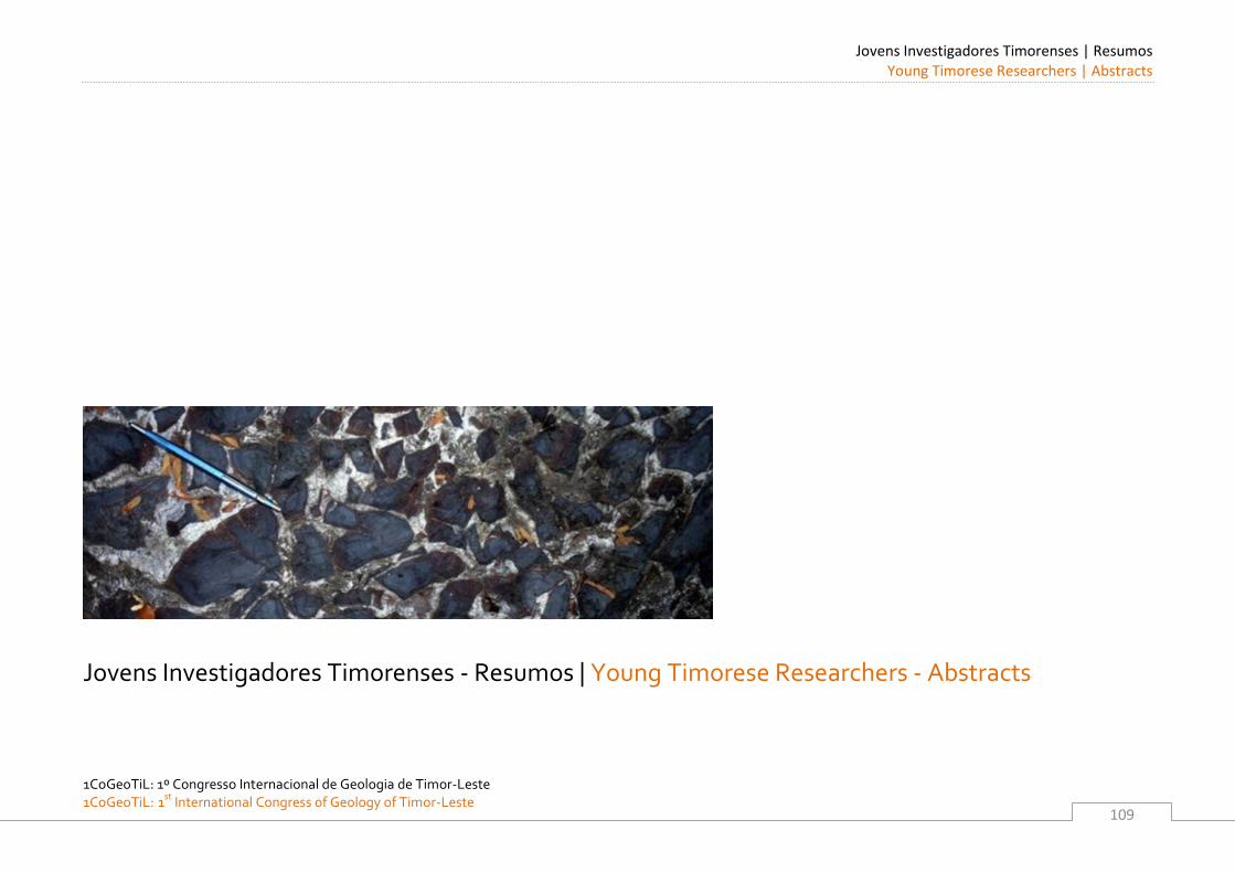
Jovens Investigadores Timorenses | Resumos Young Timorese Researchers | Abstracts
1CoGeoTiL: 1º Congresso Internacional de Geologia de Timor-Leste 1CoGeoTiL: 1st
International Congress of Geology of Timor-Leste
109
Jovens Investigadores Timorenses - Resumos | Young Timorese Researchers - Abstracts
Jovens Investigadores Timorenses | Resumos Young Timorese Researchers | Abstracts
1CoGeoTiL: 1º Congresso Internacional de Geologia de Timor-Leste
1CoGeoTiL: 1st International Congress of Geology of Timor-Leste
110
Jovens Investigadores Timorenses | Resumos Young Timorese Researchers | Abstracts
1CoGeoTiL: 1º Congresso Internacional de Geologia de Timor-Leste 1CoGeoTiL: 1st
International Congress of Geology of Timor-Leste
111
Caracterização dos movimentos de massa no distrito de Baucau (Zona Este)
APOLINÁRIO EUSÉBIO ALVES Departamento de Geociências, Escola de Ciências e Tecnologia da Universidade de Évora, Portugal; Secretaria de Estado dos Recursos Naturais, Timor-Leste. E-mail: [email protected] Neste trabalho é feita uma avaliação da perigosidade dos movimentos de vertente no distrito de Baucau, nos sub-distritos da parte Leste. Partiu-se do levantamento e da análise histórica dos eventos ocorridos no passado. Um mapa que corresponde ao inventário dos movimentos de vertente foi elaborado durante o trabalho de campo contendo a definição das tipologias encontradas, a classificação e as áreas afetadas pelos movimentos de vertente. A correlação entre os movimentos de vertente, a geologia, solos, precipitação entre outros fatores foi feita para procurar compreender as relações entre estas variáveis. Posteriormente um mapa de suscetibilidade aos movimentos de vertente (quedas de blocos, escorregamentos e fluxos) foi elaborado recorrendo a ferramentas SIG. Durante o período em que decorreu o trabalho de campo foi implantada uma rede de monitorização, utilizando um GPS diferencial, em 2 áreas instáveis, a fim de estabelecer a quantidade do movimento do escorregamento e a sua relação com os dados de precipitação existentes. Finalmente foram elaboradas recomendações para serem implementadas em futuros Planos de Ordenamento do Território e Gestão de Emergências.
NOTAS | NOTES
_________________________________________
_________________________________________
_________________________________________
_________________________________________
_________________________________________
_________________________________________
_________________________________________
_________________________________________
_________________________________________
_________________________________________
Jovens Investigadores Timorenses | Resumos Young Timorese Researchers | Abstracts
1CoGeoTiL: 1º Congresso Internacional de Geologia de Timor-Leste
1CoGeoTiL: 1st International Congress of Geology of Timor-Leste
112
Mélange and Thrust Geometry of the western Covalima District, Timor Leste
DIANA FATIMA DA COSTA 1, ALDA LUISA GUTERRES DE’SA BENEVIDES
1 AND UEECHAN CHWAE
2 1. Directorate of Geology and Mineral Resources (DNGRM), Secretariat of State for Natural Resources (SERN) 1st
Floor Fomento Building, P.O. Box 171 Mandarin, Dili, Timor Leste. E-mail: [email protected],
2. Department of Geological Mapping, Korea Institute of Geoscience and Mineral Resources (KIGAM) Gwahang-no
124, Yuseong-gu, Dajeon, 305-350 Korea. E-mail: [email protected]
Considering the structural geometry of the western part of Covalima (CV) District, SW of Timor-Leste, the
essentially required concept from the geometrical view point is the existence of the huge sedimentary mélange
having the very slow dip angle apparently towards northwest or southeast. Without any previous information,
the mélange of the CV Sheet would be apparently classified to sedimentary mélange, which size in CV Sheet has
been estimated to up to > 15 km of E-W width and > 10 km, N-S length. The mélange seems to have brought up
the pre-Permian to the Upper Miocene mega blocks from the deep depth and the depth of continental shelf.
Those blocks have been preliminarily correlated to the pre-Permian Lolotoi Complex (schist, metavolcanics)
around Fohorem Subdistrict, the Middle to Late-Triassic Aitutu Formation (limestone, mudstone, sandstone)
between Mt. Maubesse (615 m) and Mt. Nanu (925 m) and the Upper Triassic Babulu Formation (mudstone,
limestone) from Nanu village to the southern hill of Bibitali village during the KOICA project, 2011.
The mélange might be correlated to the Bobonaro Formation (?), which age had been considered to the Middle
Miocene (Audley-Charles, 1968), which, however, might be controversial because of containing very young (the
Upper most Pleistocene to Holocene?) materials such as slightly decayed trees, which might be locally occurred
because of listric faulting. The matrix of the mélange consists of various colored scaly clay or mud and includes
unsorted angular-subangular fragments or huge boulders. The matrix is commonly characterized with wet, soft
and plastic deformation and sheared cleavage, which movement sense generally indicates towards southeast.
Rock fragments or even boulders within the partly unconsolidated matrix also indicate shear movement sense
to the southwest by σ-, or δ-type rotation. Contrarily, some of them look like just debris flows fallen down at
once, showing no shear sense. It seems the mélange brought up several manganese sandstone strata, which are
heavy and contain low magnetic properties, and metavolcanic rocks from the deep depth.
NOTAS | NOTES
_________________________________________
_________________________________________
_________________________________________
_________________________________________
_________________________________________
_________________________________________
_________________________________________
_________________________________________
_________________________________________
_________________________________________
Jovens Investigadores Timorenses | Resumos Young Timorese Researchers | Abstracts
1CoGeoTiL: 1º Congresso Internacional de Geologia de Timor-Leste 1CoGeoTiL: 1st
International Congress of Geology of Timor-Leste
113
Based on the above, the mélange of the CV Sheet would be classified to the shear-zone mélange rather than
that of diapiric mélange (Orange, 1990).
The Mesak thrust (MSTH), which name was given by us through this study, is classified to klippe appearing at a
thousand meters above sea level and transports the massive and thick limestone (local thickness: ca. 450 m) to
the southeast to the south. There are about five limestone klippes, which are much smaller than that of the
Mesak block. Around the MSTH, at the bottom of the massive limestone, there are oncoidal limestone and
cherts mixed with smeared, baked, very hard and angular metapsammite fragments showing chaotic azimuth
of fault striation. The thick limestone regards to be allochthon as a nappe, while the below schist should be
autochthon, which correlates to the Lolotoi Formation. The problem of thrust geometry is how apparently
younger limestone could be nappe on the pre-Permian schist. All of the above remain as a further study.
KOICA: Korea International Cooperation Agency
NOTAS | NOTES
_________________________________________
_________________________________________
_________________________________________
_________________________________________
_________________________________________
_________________________________________
_________________________________________
_________________________________________
_________________________________________
_________________________________________
Jovens Investigadores Timorenses | Resumos Young Timorese Researchers | Abstracts
1CoGeoTiL: 1º Congresso Internacional de Geologia de Timor-Leste
1CoGeoTiL: 1st International Congress of Geology of Timor-Leste
114
Cartografia e estrutura dos calcários ornamentais da região de Beheda. Implicações para
a exploração.
HÉLIO DA COSTA CRISTOVÃO Departamento de Geociências, Escola de Ciências e Tecnologia da Universidade de Évora, Portugal; Secretaria de Estado dos Recursos Naturais, Timor-Leste. E-mail: [email protected] Com este trabalho procurou-se aprofundar a cartografia e estrutura da área estudada. Considerou-se fundamental neste estudo o aprofundamento da informação geológica acerca das rochas com valor económico na região, nomeadamente dos calcários e mármores aflorantes. Os resultados obtidos permitir melhorar o detalhe da cartografia existente, marcando os afloramentos e os limites das rochas e unidades geológicas encontradas: calcários; mármores, peridotitos, epidotitos, argilitos e arenitos, conglomerados, etc. De marcante importância foi a descoberta de lavas em almofada próximo da zona de contacto entre rochas sedimentares com as rochas ígneas da Formação Aileu. A cartografia detalhada permitiu também ter uma melhor percepção da estrutura e do potencial para exploração económica quer dos mármores da região de Behau, quer dos calcários aflorantes na região de Beheda.
NOTAS | NOTES
_________________________________________
_________________________________________
_________________________________________
_________________________________________
_________________________________________
_________________________________________
_________________________________________
_________________________________________
_________________________________________
_________________________________________
Jovens Investigadores Timorenses | Resumos Young Timorese Researchers | Abstracts
1CoGeoTiL: 1º Congresso Internacional de Geologia de Timor-Leste 1CoGeoTiL: 1st
International Congress of Geology of Timor-Leste
115
Cartografia e estrutura do contacto entre a formação de Aileu e a formação de Wailuli.
Implicações geodinâmicas e para os recursos minerais.
NENE SOARES VALENTE CRISTOVÃO Departamento de Geociências, Escola de Ciências e Tecnologia da Universidade de Évora, Portugal; Secretaria de Estado dos Recursos Naturais, Timor-Leste. E-mail: [email protected] O presente trabalho consiste na aplicação e conclusão de metodologias para a caracterização da estrutura de uma área na Laclo Norte marcada pela intersecção de zonas de falhas. Esta área situa-se no centro norte do distrito de Manatuto. Os trabalhos se concentraram no intervalo aflorante das rochas da Formação de Wailuli, Formação de Aitutu, Aluviões Recentes e Formação de Aileu. O trabalho em questão foi baseado no conceito de cartografia. Para tanto utilizaram-se métodos indirectos como a análise e interpretação de imagens de satélite, modelo digital de elevação e fotografias aéreas e finalizando com métodos directos de levantamentos de detalhe em escala de afloramento. Os resultados obtidos permitiram verificar que a região estudada apresenta-se principalmente condicionada por estruturas com sentido NW e SE. Para os estudos estruturais e estratigráficos os levantamentos foram feitos aproveitando os vales das ribeiras e as zonas montanhosas qu permitiam o acesso.
NOTAS | NOTES
_________________________________________
_________________________________________
_________________________________________
_________________________________________
_________________________________________
_________________________________________
_________________________________________
_________________________________________
_________________________________________
_________________________________________
Jovens Investigadores Timorenses | Resumos Young Timorese Researchers | Abstracts
1CoGeoTiL: 1º Congresso Internacional de Geologia de Timor-Leste
1CoGeoTiL: 1st International Congress of Geology of Timor-Leste
116
The Aitutu Formation and Associated Units at Soibada, Timor Leste: potential source
rocks for Timor Leste’s petroleum system
FLORENTINO FERREIRA School of Earth and Environmental Sciences, University of Western Australia, 35 Stirling Highway, Crawley, WA 6907. E-mail: [email protected] This thesis presents a reconstruction of the stratigraphic succession of the Aitutu Formation and associated units in the Sahem River near Soibada, Timor Leste. The aims are to better understand the Gondwana Sequence in Timor Leste and the hydrocarbon potential in onshore parts of the country. The results of stratigraphic logging of eight sections are presented based on lithostratigraphy and biostratigraphy. The study recognizes eight lithostratigraphic units from the eight sections logged; unit 1 is predominantly marl (sections 1, 2, and 7); unit 2 is characterized by thinly bedded radiolarian-rich wackestone (section 8); unit 3 is distinguished by thick bedded wackestone (section 8); unit 4 is characterized by wavy to planar interbedded shale and wackestone (section 8); unit 5 is distinguished by thickly bedded wackestone with some chert nodules (sections 8); unit 6 is characterized by interbedded shale and limestone (sections 5, 8); unit 7 is distinguished by thickly bedded wackestone with some chert nodules (sections 4, 8); and unit 8 is characterized by interbedded quartz sandstone and sandy shale (section 6). Units 1-7 are considered to represent a conformable succession. Unit 8 is present in an isolated outcrop. Ages of the lithostratigraphic units are determined from palynomorphs and foraminifera. Unit 1 is defined as Late Triassic (Rhaetian) to Early Jurassic based on foraminifera and palynology. Units 2 and 3 may range from Norian to Rhaetian (Late Triassic) from their stratigraphic position. Unit 4 is Norian determined from palynological evidence. Based on stratigraphic position unit 5 is defined as Norian. Palynological and foraminiferal assemblages indicate that unit 6 is Norian. The age of unit 7 is uncertain, but possibly Norian due to its stratigraphic position in section 8. An age within the Late Anisian to Early Carnian is assigned to unit 8 based on palynology.  Based on biostratigraphy, unit 1 is correlated to the Wailuli Formation that has a type section approximately 40 km west from the study area. Units 2, 3, 4, 5, 6 and 7 are correlated to the Aitutu Formation that has a type section approximately 40 km west from the study area. Unit 8 is correlated to the Babulu Formation with type area approximately 120 km west from the Sahem River study area.
NOTAS | NOTES
_________________________________________
_________________________________________
_________________________________________
_________________________________________
_________________________________________
_________________________________________
_________________________________________
_________________________________________
_________________________________________
_________________________________________
Jovens Investigadores Timorenses | Resumos Young Timorese Researchers | Abstracts
1CoGeoTiL: 1º Congresso Internacional de Geologia de Timor-Leste 1CoGeoTiL: 1st
International Congress of Geology of Timor-Leste
117
Ten facies are linked in three facies associations. Facies associations 1 and 2 are interpreted as basinal facies involving hemipelagic deposition from suspension. Whereas, facies association 3 of siliciclastic sandstone interbedded with sandy shale is interpreted as the upper transitional zone of a fluvial dominated delta, proximal to the main distributary system. Rock-Eval pyrolysis was undertaken on black shale beds in the Aitutu Formation. The results of the Rock-Eval analysis are confidential to the sponsoring company. Keywords: Stratigraphy, biostratigraphy, Aitutu Formation, Soibada Timor Leste, Source potential
NOTAS | NOTES
_________________________________________
_________________________________________
_________________________________________
_________________________________________
_________________________________________
_________________________________________
_________________________________________
_________________________________________
_________________________________________
_________________________________________
Jovens Investigadores Timorenses | Resumos Young Timorese Researchers | Abstracts
1CoGeoTiL: 1º Congresso Internacional de Geologia de Timor-Leste
1CoGeoTiL: 1st International Congress of Geology of Timor-Leste
118
artogra a e estrutura geol gica da regi o leste do anticlinal de ribas - Implica o para
a g nese de hidrocarbonetos
VALENTE FERREIRA Departamento de Geociências, Escola de Ciências e Tecnologia da Universidade de Évora, Portugal; Secretaria de Estado dos Recursos Naturais, Timor-Leste. E-mail: [email protected] Na região leste de Cribas foram cartografadas diversas formações geológicas: Formação de Atahoc do P rmico Inferior, Formação de Cribas do P rmico Superior, Formação de Aituto do Triásico, a Formação de Ainaro com uma idade de Plio-Plistoc nico e os Aluviões Recentes. Todas estas formações são de fácies sedimentares compostas essencialmente por sedimentos clásticos e materiais carbonatados. A Formação de Ainaro composta por calhaus de diversas formas, havendo o predomínio de calhaus do Complexo de Lolotoi no seio de uma matriz argilosa. As formações de Atahoc e de Cribas encontram-se separadas por um lão de basalto intercalado em margas vermelhas e calcários margosos. Do ponto de vista estrutural de realçar a existência de duas fases de deformação. A D1 que responsável pela generalidade dos dobramentos da região dos quais se destaca o anticlinal de Cribas; trata-se de uma dobra aberta com eixo subhorizontal orientado E-W e flancos inclinando cerca de 25o. As principais estruturas D2 são grandes desligamentos N-S com uma cinemática esquerda e as dobras menores associadas. Ao longo da ribeira de Hacraun, possível evidenciar que, enquanto a D1 apresenta dobras com planos axiais verticais, os planos axiais da D2 tendem a ser horizontais. No que diz respeito s principais falhas D2 N-S, de destacar a que existe ao longo da ribeira de Sumasse (a Oeste da zona estudada) e as da ribeira de Hacraun (falhas de Hacraun N e de Hacraun S). Como típico dos ambientes estruturais em que predominam os desligamentos, desenvolvem-se uma s rie de estruturas de acomodação D2 de que se destacam um cavalgamento E-W afectando o núcleo do anticlinal e vergente para sul, e o cavalgamento NE-SW de Tuqueti que leva a Formação de Cribas a cavalgar a Formação de Aituto. Estas estruturas condicionam a ocorrência de um escoamento de petróleo no bordo E da ribeira de Tuqueti. Análises geoquímicas de algumas amostras dos argilitos da Formação de Cribas mostram que a percentagem do Carbono Orgânico Total (COT) de 0, 1 , o que signi ca que esta rocha provavelmente pode ter sido uma rocha mãe geradora de hidrocarbonetos. Os argilitos estudados das formações de Atahoc e de Aituto apresentam valores de COT inferiores a 0,71%. Palavras-chave: st utu a geol gica, anticlinal de i as, g nese de hid oca onetos.
NOTAS | NOTES
_________________________________________
_________________________________________
_________________________________________
_________________________________________
_________________________________________
_________________________________________
_________________________________________
_________________________________________
_________________________________________
_________________________________________
Jovens Investigadores Timorenses | Resumos Young Timorese Researchers | Abstracts
1CoGeoTiL: 1º Congresso Internacional de Geologia de Timor-Leste 1CoGeoTiL: 1st
International Congress of Geology of Timor-Leste
119
Cartografia, estratigrafia e paleontologia da passagem Triásico-Jurássico na região de
Manatuto.
AQUILES TOMÁS FREITAS Departamento de Geociências, Escola de Ciências e Tecnologia da Universidade de Évora, Portugal; Secretaria de Estado dos Recursos Naturais, Timor-Leste. E-mail: [email protected] Este trabalho decorreu na região de Manatuto, Timor-Leste. Fez-se o levantamento das unidades geológicas e analisou-se os resultados á luz da cartografia de recursos minerais, sobretudo da génese dos hidrocarbonetos. Cartografamos seis unidades litoestratigráficas: Unidade dos Calcários, é a formação geológica mais antiga na área do trabalho correspondendo a calcários, dolomitos, níveis carbonatados com sílex, entre outros, encontramos fósseis de Halobia e Monotis. Unidade de Wailuli Inferior é uma alternância entre argilitos e arenitos onde dominam os arenitos. Unidade Wailuli Médio é alternância os argilitos com arenitos, onde dominam os argilitos. Unidade Wailuli Superior é alternância entre argilitos, arenitos e conglomerados, no topo, pode-se encontrar gesso e pseudomorfos de sal. As três unidades de UWI, UWM. IWS correspondem à Formação Wailuli. Unidade dos Conglomerados (Formação Suai) e a Unidade dos aluviões (UA) são as mais recentes, do quaternário, constituídas por conglomerados polimíticos. As rochas do Triásico Superior até ao Triásico Inferior em Timor são arenitos e argilitos sendo potenciais rochas geradoras.
NOTAS | NOTES
_________________________________________
_________________________________________
_________________________________________
_________________________________________
_________________________________________
_________________________________________
_________________________________________
_________________________________________
_________________________________________
_________________________________________
Jovens Investigadores Timorenses | Resumos Young Timorese Researchers | Abstracts
1CoGeoTiL: 1º Congresso Internacional de Geologia de Timor-Leste
1CoGeoTiL: 1st International Congress of Geology of Timor-Leste
120
On the Baer Active Fault, Covalima District, Timor-Leste
HÉLIO CASIMIRO GUTERRES 1,2, ARMINDO ANTÓNIO DE JESUS
2 AND UEECHAN CHWAE
3 1. Responsável do Lab. Nacional de Geologia e Consultor de projecto de KOIKA, DNRGM; Secretaria de Estado de Recursos Naturais (SERN). E- mail: [email protected] 2. Directorate of Geology and Mineral Resources (DNGRM), Secretariat of State for Natural Resources (SERN) 1st Floor Fomento Building, P.O. Box 171 Mandarin, Dili, Timor Leste. E-mail: [email protected] 3. Department of Geological Mapping, Korea Institute of Geoscience and Mineral Resources (KIGAM) Gwahang-no 124, Yuseong-gu, Dajeon, 305-350 Korea. E-mail: [email protected] During geological mapping around Baer village, the western part of Covalima District, we faced the Maubui riverside sediments, which are mainly composed of unconsolidated sediments and frequently and chaotically include mega breccias and boulders along the V-shape valley. To identify morphotectonic characteristics of the unconsolidated strata along the riverside, we needed to understand how many river terrace sediments are. To get the vertical thickness of all the terraces, a long-distance measurement has been chosen through the acute angle between the horizontal extensions at the outer edge of the highest tread and the river elevation of 250 meters above sea level. It was yielded that seven river terrace sediments had been deposited, showing vertically about 36 meter thick from the present river elevation. In addition, we found a big fault of ca. two-meter thickness, cutting the several terraces, showing the attitude of 140°/45° (dip direction) and reverse movement sense by cataclasite foliation. Referring the uplift rate around Timor Island has been known as 1∼4mm/yr during the Upper Pleistocene (Merritts, D. et al, 1998; Cox, N.L., 2009; Chiang, H.W. et al., 2010; Bakker, P.R., 2011) and considering an incision rate of the upstream of Maubiu River could be possibly much higher (ca. 1.5-5 times) than that of the uplift rates (Litchfield and Berryman, 2006), those 36-meters-thick terraces might be deposited within Holocene (ca. 7,200-1,440 yrs*), if the incision rate of the Maubui river terraces was within range of 5-25 mm/yr. Hence, it seems that the fault lays out a logical basis for an active faulting, even without age dating yet.
NOTAS | NOTES
_________________________________________
_________________________________________
_________________________________________
_________________________________________
_________________________________________
_________________________________________
_________________________________________
_________________________________________
_________________________________________
_________________________________________
Jovens Investigadores Timorenses | Resumos Young Timorese Researchers | Abstracts
1CoGeoTiL: 1º Congresso Internacional de Geologia de Timor-Leste 1CoGeoTiL: 1st
International Congress of Geology of Timor-Leste
121
Within about one-kilometer’s distance around the Baer village and along the Maubui River, we found eight more active faults, having the characteristics of reactivated basement fault and shear fault segments of the main fault striking N50°E. Some of them showed up to about six-meters vertical throw, which might have been estimated like as ca. six-times earthquakes (≥MM .0) had occurred around the riverside within Holocene (around 10,000 14C yrs). The intermittently continuous presence of mega breccias and boulder along the river valley might be assumed as the byproduct of seismic landslide, which generally has very steep dip angle, around the river. The depth of the terrace sediments around the Baer might be graphically estimated as ca. 100 meters, if the extension of the northern mountain slope and the southern around the Baer intersect at below the river surface. This means the total thickness of the unconsolidated sediments including the seven terraces above the river might be ca. 136 m or more. Subsequently, it is geologically considered that even a pier within the river valley would not be safe for staying permanently, not because of only the presence of active faulting or possible seismic land sliding but also because of the thick wedge-type weak ground. *36m (36000 mm) / 5~25 mm/yr = ca. 7200~1440 yrs
NOTAS | NOTES
_________________________________________
_________________________________________
_________________________________________
_________________________________________
_________________________________________
_________________________________________
_________________________________________
_________________________________________
_________________________________________
_________________________________________
Jovens Investigadores Timorenses | Resumos Young Timorese Researchers | Abstracts
1CoGeoTiL: 1º Congresso Internacional de Geologia de Timor-Leste
1CoGeoTiL: 1st International Congress of Geology of Timor-Leste
122
Vulcão de lama em Timor Leste; os materiais constituintes, o processo, a estrutura
geológica e a sua interpretação
HÉLIO CASIMIRO GUTERRES Responsável do Lab. Nacional de Geologia e Consultor de projecto de KOIKA, DNRGM; Secretaria de Estado de Recursos Naturais (SERN). E- mail: [email protected] Vulcão de lama é uma das estruturas geológicas formadas pela emissão dos materiais compostos por gás, água mineral, lama semi-liquida vindos de uma certa profundidade e são depositados a superfície da terra. As características das rochas, a subducção e a colisão entre as placas tectónicas podem ser consideradas como motor gerador de vulcão de lama. No presente trabalho apresenta-se a caracterização e identificação dos materiais constituintes do vulcão de lama em Timor Leste, nomeadamente na área de Rai Tahu (Viqueque) e Oe-silo (enclave de Oe-cusse). Apresenta de igual modo uma provável estrutura geológica que provoca a produção dos tais vulcões de lama. Segundo os estudos feitos, a lama que provoca a explosão deste fenómeno é constituída principalmente por xistos argilosos (shale) das sucessões Permicas e de Triasico (Barber et. al. 1986). Estas unidades sofrem uma pressão sobre elevada devido a força de compressão vinda do processo de colisão entre a Placa Australiana e a Placa Euro-asiatica. Segundo Carter et. al, (1976), a colisão começou do Pliocenico médio e o processo continua até a data presente. Em consequência da colisão em contínuo, foram produzidas as repetidas falhas inversas e dobras, o que dão lugar à fuga dos materiais argilosos à superfície do terreno – vulcão de lama. As observações directas feitas por nós, a forma de vulcão de lama são diferentes em dois sítios. Em Oe-silo o vulcão de lama apresenta uma forma regular ou seja a cratera principal está situada no meio e rodeada pelas pequenas crateras, enquanto em Rai Tahu as crateras são de pequenas dimensões e situadas apenas numa linha com direcção NE-SW (Fig. 1 A, C). Segundo as populações, a explosão violenta acontece anualmente, em Oe-silo nos finais de Novembro e em Rai Tahu no mês de Agosto. A ocorrência da explosão de lama pode durar até uma semana de tempo com uma altura aproximadamente de 50 m. Em Oe-silo o vulcão continua a expelir pequenas quantidades de lama ao longo do ano, quanto em Rai Tahu o vulcão de lama mantém-se em repouso sem produzir nenhum movimento de explosão. Até a data não se regista nenhum acidente que afecta as populações.
NOTAS | NOTES
_________________________________________
_________________________________________
_________________________________________
_________________________________________
_________________________________________
_________________________________________
_________________________________________
_________________________________________
_________________________________________
_________________________________________
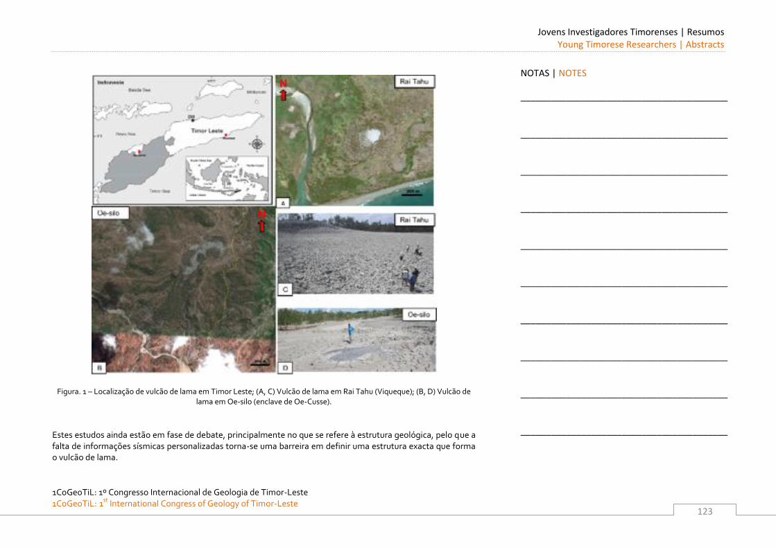
Jovens Investigadores Timorenses | Resumos Young Timorese Researchers | Abstracts
1CoGeoTiL: 1º Congresso Internacional de Geologia de Timor-Leste 1CoGeoTiL: 1st
International Congress of Geology of Timor-Leste
123
Figura. 1 – Localização de vulcão de lama em Timor Leste; (A, C) Vulcão de lama em Rai Tahu (Viqueque); (B, D) Vulcão de lama em Oe-silo (enclave de Oe-Cusse).
Estes estudos ainda estão em fase de debate, principalmente no que se refere à estrutura geológica, pelo que a falta de informações sísmicas personalizadas torna-se uma barreira em definir uma estrutura exacta que forma o vulcão de lama.
NOTAS | NOTES
_________________________________________
_________________________________________
_________________________________________
_________________________________________
_________________________________________
_________________________________________
_________________________________________
_________________________________________
_________________________________________
_________________________________________
Jovens Investigadores Timorenses | Resumos Young Timorese Researchers | Abstracts
1CoGeoTiL: 1º Congresso Internacional de Geologia de Timor-Leste
1CoGeoTiL: 1st International Congress of Geology of Timor-Leste
124
Caracterização dos movimentos de massa no distrito de Baucau (Zona Oeste)
FÉLIX JANUÁRIO GUTERRES JONES Departamento de Geociências, Escola de Ciências e Tecnologia da Universidade de Évora, Portugal; Secretaria de Estado dos Recursos Naturais, Timor-Leste. E-mail: [email protected] Na presente tese é efectuada uma avaliação da perigosidade dos movimentos de vertente no distrito de Baucau (Zona Oeste) em Timor Leste. Esta avaliação começou com o levantamento e análise historica dos eventos ocorridos no passado na área em estudo. Um mapa inventário dos movimentos de vertente foi eleborado durante o periodo de trabalho de campo, para a definição das tipologias, classificação e àrea afectada pelos movimentos de vertente, assim como a correlação entre os movimentos de vertente, a geologia, solos e precipitação entre outros factores. Posteriormente um Mapa de Susceptibilidade aos movimentos de vertente (quedas de blocos, escorregamentos e fluxos) foi elaborado. Foi implantado uma rede de monitorização, utilizando um GPS diferencial, em 2 áreas instáveis, a fim de estabelecer a quantidade do moviemnto do escorregamento e a ua relação com a precipitação. Finalmente foram elaboradas recomendações a implementar nos Planos de Ordenamento do Território e Gestão de Emergências.
NOTAS | NOTES
_________________________________________
_________________________________________
_________________________________________
_________________________________________
_________________________________________
_________________________________________
_________________________________________
_________________________________________
_________________________________________
_________________________________________
Jovens Investigadores Timorenses | Resumos Young Timorese Researchers | Abstracts
1CoGeoTiL: 1º Congresso Internacional de Geologia de Timor-Leste 1CoGeoTiL: 1st
International Congress of Geology of Timor-Leste
125
artogra a e estrutura geol gica da regi o oeste do anticlinal de ribas - Implica o para
a g nese de hidrocarbonetos
GABRIEL OLIVEIRA Departamento de Geociências, Escola de Ciências e Tecnologia da Universidade de Évora, Portugal; Secretaria de Estado dos Recursos Naturais, Timor-Leste. E-mail: [email protected] A cartogra a geológica da região oeste do anticlinal de Cribas foi feita considerando três unidades litotectónicas: unidades autóctone, parautóctone e alóctone. A unidade autóctone compreende os terraços de Ainaro e as aluviões. A unidade parautóctone constituída pelas formações de Atahoc, Cribas e Aitutu. A unidade alóctone compreende o complexo de Lolotoi, a Formação de Maubisse e a Bobonaro scaly clay. Ao longo da sua evolução tectónica sucederam-se três fases de deformação (D1, D2 e D3). D1 relaciona-se com a formação do anticlinal de Cribas que apresenta um eixo E-W bem como com o empilhamento da unidade alóctone. A D2 gerou os grandes desligamentos da região bem como as estruturas associadas. A D3 relaciona-se com o levantamento da ilha associado a grandes falhas normais transversais. A evolução geodinâmica da região do anticlinal de Cribas compreende: 1) formação do anticlinal quando a margem da placa australiana estava a subductar por baixo do prisma acrecionário de Banda; 2) empilhamento da unidade alóctone relacionada com a colisão entre a margem continental australiana e o arco de Banda com o consequente levantamento da ilha de Timor durante o Terciário e uaternário. Do ponto de vista dos hidrocarbonetos de realçar a existência de rochas mãe, reservatório e selante. As rochas mãe são das formações Atahoc, Cribas e Aitutu. As rochas reservatório são da formação de Atahoc. Os horizontes selantes são das formações Atahoc e Cribas. O estudo geoquímica realizado mostra que todas as litologias estudadas são pobres em mat ria orgânica e altas em Tmax; os valores elevados de Tmax indicam que as rochas estavam sujeitas a altas temperaturas provavelmente relacionadas com o empilhamento da unidade alóctone. O sistema de falhas onde se integra o desligamento principal de Sumasse pode in uenciar a migração dos hidrocarbonetos, podendo a sua in uência chegar aos campos petrolíferos do mar de Timor.
NOTAS | NOTES
_________________________________________
_________________________________________
_________________________________________
_________________________________________
_________________________________________
_________________________________________
_________________________________________
_________________________________________
_________________________________________
_________________________________________
Jovens Investigadores Timorenses | Resumos Young Timorese Researchers | Abstracts
1CoGeoTiL: 1º Congresso Internacional de Geologia de Timor-Leste
1CoGeoTiL: 1st International Congress of Geology of Timor-Leste
126
Cartografia e estrutura do contacto entre as Formações de Lolotoi e de Wailuli ao longo
da Ribeira de Sumasse.
HENRIQUE GUSMÃO MENDONÇA PEREIRA Departamento de Geociências, Escola de Ciências e Tecnologia da Universidade de Évora, Portugal; Secretaria de Estado dos Recursos Naturais, Timor-Leste. E-mail: [email protected] Neste trabalho apresenta-se a cartografia realizada numa área com cerca de 30 km2, a SW de Manatuto. As duas principais formações que afloram são a Formação Lolotoi e a Formação de Wailuli, ocorrendo ainda calcários atribuídos à Formação de Maubisse e áreas com depósitos de cobertura recentes (aluviões e terraços). Apesar de não ter sido possível observar directamente, os contactos entre estas várias unidades, em termos geométricos a Formação de Wailuli representa o autóctone da região e sobre esta instalou-se, por carreamento, a Formação de Lolotoi. Os calcários da Formação de Maubisse parecem corresponder a clipes de um outro manto de carreamento diferente, sobre as formações anteriores. A Formação de Lolotoi é a mais deformada e é a única que apresenta uma fase de deformação marcada pela presença de xistosidade. Apesar da dispersão de atitudes parece apontar para que esta xistosidade esteja dobrada por uma fase posterior Os depósitos quaternários, em particular a Formação de Ainaro, indicam um importante uplift da região no período recente.
NOTAS | NOTES
_________________________________________
_________________________________________
_________________________________________
_________________________________________
_________________________________________
_________________________________________
_________________________________________
_________________________________________
_________________________________________
_________________________________________
Jovens Investigadores Timorenses | Resumos Young Timorese Researchers | Abstracts
1CoGeoTiL: 1º Congresso Internacional de Geologia de Timor-Leste 1CoGeoTiL: 1st
International Congress of Geology of Timor-Leste
127
Stratigraphic Re-evaluation of the Bazol Anticline, Bobonaro Subdistrict, Timor Leste
ZELIA DA GLORIA DOS SANTOS School of Earth & Environment, the University of Western Australia. E-mail: [email protected] Audley-Charles 1968 (Memoir geological society of London 4) mapped the Bazol Anticline in an area to the south of Bobonaro, Timor Leste. The Bazol Anticline was defined on the basis of the distribution of the Triassic Aitutu Formation on either side of the Permian Cribas Formation. There was no consistent structural evidence for the anticline (Audley-Charles 1968, p. 50-51). The identification of the Cribas Formation in the area was based on foraminiferal age determinations by D. Belford of the Australia Bureau of Mineral Resources in 1960 and 1961, and taken as Permian. Re-examination of Timor Oil Ltd material investigated by Belford shows that the samples are Triassic not Permian in age. Also field sampling along the Bazol River in the supposed core of the anticline found no Permian strata. Triassic units are exposed along the southern side of the River where as a structural mélange zone with gas seeps is present on the northern side. Therefore a stratigraphic basis for a “Bazol Anticline” does not exist.
NOTAS | NOTES
_________________________________________
_________________________________________
_________________________________________
_________________________________________
_________________________________________
_________________________________________
_________________________________________
_________________________________________
_________________________________________
_________________________________________
Jovens Investigadores Timorenses | Resumos Young Timorese Researchers | Abstracts
1CoGeoTiL: 1º Congresso Internacional de Geologia de Timor-Leste
1CoGeoTiL: 1st International Congress of Geology of Timor-Leste
128
Estudo da estrutura da série metamórfica de Dili. Implicações geodinâmicas
ILCE HANJAN DA SILVA Departamento de Geociências, Escola de Ciências e Tecnologia da Universidade de Évora, Portugal; Secretaria de Estado dos Recursos Naturais, Timor-Leste. E-mail: [email protected] A Série metamórfica de Dili ou Formação de Aileu segundo Audley-Charles (1968) é uma sequência de rochas metasedimentar que são a chave para a compreensão do processo de colisão entre o bloco australiano e o mar de Banda. Esta sequência de rochas sofreu um conjunto de processos tectónicos e metamórficos que implicou a sobreposição de diferentes graus metamórficos e diversas fases tectónicas. Neste trabalho procurou contribuir-se para o aprofundamento do conhecimento destes processos quer pelo estudo estrutural das meso-estruturas encontradas, quer através da ligação dessas estruturas à escala microscópica. Os trabalhos realizados permitiram confirmar as fases deformacionais previamente descritas por outros autores, nomeadamente os trabalhos de investigadores Barber & Carter. O estudo de metamorfismo e a sua ligação às diferentes fases tectónicas foi iniciado, porém deverá ser aprofundado, através de mais análises petrográficas quer através de geoquímica de elementos maiores e menores.
NOTAS | NOTES
_________________________________________
_________________________________________
_________________________________________
_________________________________________
_________________________________________
_________________________________________
_________________________________________
_________________________________________
_________________________________________
_________________________________________
Jovens Investigadores Timorenses | Resumos Young Timorese Researchers | Abstracts
1CoGeoTiL: 1º Congresso Internacional de Geologia de Timor-Leste 1CoGeoTiL: 1st
International Congress of Geology of Timor-Leste
129
Listric Faulting of Mt. Mesak–Fohorem: Geomorphologic and Structural Significance
RONALD ONORATO SOARES 1, ANA BELA BARRETO MONIZ
1 AND UEECHAN CHWAE
2 1. Directorate of Geology and Mineral Resources (DNGRM), Secretariat of State for Natural Resources (SERN) 1st Floor Fomento Building, P.O. Box 171 Mandarin, Dili, Timor Leste. E-mail: [email protected], [email protected] 2. Department of Geological Mapping, Korea Institute of Geoscience and Mineral Resources (KIGAM) Gwahang-no 124, Yuseong-gu, Dajeon, 305-350 Korea. E-mail: [email protected] The observed deformation of the southern part of Mt. Mesak (1,455 m) in Fohorem subdistrict is apparently classified to three. The first deformation, mainly in mica schist and phyllonite, is thrust duplex caused by a possible process of accretionary prism from the south and the second is a recumbent thrust brought the massive limestone from the north or the northwest. The final one is distinctly listric fault (LFT) towards south. The main objective of this work is to describe the LFTs formed low relieves on the southern slope of the northern Mt. Mesak. This description is based on the analysis of topographic characteristics, frontal fault gouge, and the constituent materials exposed in the field. The topography of the studied area has the southwards staircase feature with a downward direction. Along the road from the west of Fohorem to the northeast of Lactos village, the topographic slope shows beautiful concave shape with variable size, which is clearly visible from the small size of ca. 10 m up to 2 kilometer. There are initially several kilometer-size LFTs. Each big LFT yielded several smaller LFTs and each smaller LFT produced relatively much smaller size. Consequently are there fanwise trajectories of the LFT movement. At each frontal toe part of big and small LFTs, thick fault gouge with downward reverse movement sense is cropped out at the toe part along road side and is inducing underground water, which makes the road deeply wet and sometimes small ponds. Each fault gouge compounded with clay and sheared fragments of schist and limestone occurs like as flat layer and depends its horizontal extension on the size of LFT. The fault gouge is one of the main factors controlling transport and mechanical properties of the LFT zone. The LFT exposed in this area is an important factor to change the geological boundary and is like a natural museum for geologist to observe the exposed concave geometry.
NOTAS | NOTES
_________________________________________
_________________________________________
_________________________________________
_________________________________________
_________________________________________
_________________________________________
_________________________________________
_________________________________________
_________________________________________
_________________________________________
Jovens Investigadores Timorenses | Resumos Young Timorese Researchers | Abstracts
1CoGeoTiL: 1º Congresso Internacional de Geologia de Timor-Leste
1CoGeoTiL: 1st International Congress of Geology of Timor-Leste
130
Mainly massive limestone including peloid and a small amount of oolitic limestone at the Mt. Mesak is not quite clear yet whether or not the older limestone than the below pre-Permian Lolotoi Formation, or the Late Triassic Aitutu Formation derived from the Gondwana & Australian-Margin Megasequences (Haig, et al., 2007), or the Early Miocene Cablac Limestone (Haig, et al., 2008). If the massive limestone was the Cablac Limestone, and if the relationship between the upper massive Miocene limestone and the lower pre-Permian mica schist was geometrically klippe, it is not easily understood the thrust geometry unless the overlapped thrust showed prolonged out-of-sequence thrusting with the feedback of interacted erosion (McClay and Whitehouse, 2004). The LFTs were certainly the final phenomena after the klippe especially around the Fohorem subdistrict. The presence of Timor Island has been known as a product of the Banda arc-Australian continent collision (Karig, et al., 1987; Harris, 2000; Carlton, et al., 2002; Charlton, 2004; Harris, 2006; Haig and McCartain, 2008; Keep and Haig, 2009). However, the full cross section of Timor Leste seems to be considered further with the concept of punctuated climate effect linked to thrust geometry and convergence rate.
NOTAS | NOTES
_________________________________________
_________________________________________
_________________________________________
_________________________________________
_________________________________________
_________________________________________
_________________________________________
_________________________________________
_________________________________________
_________________________________________
Jovens Investigadores Timorenses | Resumos Young Timorese Researchers | Abstracts
1CoGeoTiL: 1º Congresso Internacional de Geologia de Timor-Leste 1CoGeoTiL: 1st
International Congress of Geology of Timor-Leste
131
Landslide geomorphology of the East Timor mountain belt
SARA F. V. SOARES 1, MIKE SANDIFORD
2, CECILIA FREITAS 3, JOAO EDMUNDO DOS REIS
3, JOAQUINA BARBOSA 3
1. School of Earth Sciences, University of Melbourne, Victoria 3010, Australia. E-mail: [email protected] 2. School of Earth Sciences, University of Melbourne, Victoria 3010, Australia. E-mail: [email protected] 3. State Secretariat for Natural Resources, Edifício Fomento, Rua Dom Aleixo Corte Real, Mandarim, Dili, Timor-Leste Mass movements such as landslides and debris flows are important agents of erosion in steep mountains, and are significant landform processes in Timor-Leste. The dominant triggers are earthquakes and high-intensity precipitation events. Timor-Leste is vulnerable to a number of natural hazards, including landslides, with little capacity for response. Seasonal monsoon rains falling on steep slopes cause frequent flash flooding and landslides, which regularly damage and destroy infrastructure, especially in rural areas. Little is known about the contribution of landslides to relief destruction and sediment flux at the mountain belt scale. This study is not only concerned with understanding and quantifying landslide contribution to erosion at different scales, but also adds to the growing recognition that landsliding is a primary control on the geometric development, incision history and sediment discharge of watersheds by investigating a large Quaternary (>61 Ka) landslide in the district of Ainaro. It explores how landslides have controlled the initiation and modification of the Ainaro watershed in the tropical climate of East Timor. Size distribution of landslides in East Timor was mapped using aerial photograph interpretation (API) of one set of detailed aerial photographs acquired in (2001), in order to investigate the contribution of landslides to the sediment flux of this part of the Timor orogen. The distribution of an inventory of 2005 landslides exhibits a very clear power law trend over two orders of area magnitude (~102 – 100 km2).
NOTAS | NOTES
_________________________________________
_________________________________________
_________________________________________
_________________________________________
_________________________________________
_________________________________________
_________________________________________
_________________________________________
_________________________________________
_________________________________________
Jovens Investigadores Timorenses | Resumos Young Timorese Researchers | Abstracts
1CoGeoTiL: 1º Congresso Internacional de Geologia de Timor-Leste
1CoGeoTiL: 1st International Congress of Geology of Timor-Leste
132
Field evidence of an extremely large (~2.2 x 10⁹ m3) Quaternary (> ~61.2 Ka) landslide in the district of Ainaro is presented for the first time in this study. Referred to as the ‘Ainaro collapse’, a conceptual landscape evolution model of this prominent geomorphological feature in the Ramelau range is developed, and the controls of mass wasting and erosion in channels on the topographic development of the landscape is investigated. Data presented here implies that possibly a strong seismic event resulted in the displacement of 2.2 km3 of mass. A further 0.3 km3 of mass of material was removed by subsequent modification of the landslide scar through headward erosion. Morphometric information suggests that landslides have controlled the geometric development of the Ainaro headwaters over scales up to three orders of magnitude. An estimate erosion rate of 0.05 mm yr-1 was calculated for the ‘Ainaro collapse’ using a minimum age of 62 Ka obtained from U-Th analysis of speleothem calcite that had developed locally over clasts within the landslide fill.
NOTAS | NOTES
_________________________________________
_________________________________________
_________________________________________
_________________________________________
_________________________________________
_________________________________________
_________________________________________
_________________________________________
_________________________________________
_________________________________________
Jovens Investigadores Timorenses | Resumos Young Timorese Researchers | Abstracts
1CoGeoTiL: 1º Congresso Internacional de Geologia de Timor-Leste 1CoGeoTiL: 1st
International Congress of Geology of Timor-Leste
133
A Possible Manganese Horizon of Covalima Sheet, Timor Leste
UBALDO SA’VIO SIFA’NICO FERNANDES DE SOUSA 1, JOANICO PIRES
1 AND UEECHAN CHWAE
2 1. Directorate of Geology and Mineral Resources (DNGRM), Secretariat of State for Natural Resources (SERN) 1st Floor Fomento Building, P.O. Box 171 Mandarin, Dili, Timor Leste. E-mail: [email protected] , [email protected] 2. Department of Geological Mapping, Korea Institute of Geoscience and Mineral Resources (KIGAM) Gwahang-no 124, Yuseong-gu, Dajeon, 305-350 Korea. E-mail: [email protected] The geological mapping of the western part of Covalima District has been focalized to trace any key horizon for understanding the structural geometry within the sheet so that we could identify some enrichment area of magnetite and other places of weakness. Their distribution was mainly controlled by folding and thrusting in and around Fohorem Subdistrict. We recognized an intermittently continuous sandstone horizon, which shows the black brown, heavy, subround shape like as concretion with naked eyes. The sandstone bed generally has not significant magnetic component. Despite the abundance and the wealth of metals contained iron, some dark-colored metavolcanic rocks such as serpentinite and basalt were excluded in the field area. Considering the manganese has been generally developed from the deep ocean floor, which contains extremely large quantities of nodules ranging from centimeters to decimeters in diameter, the manganese concretions seem to be transported to the sandstone layer and might had been brought up from the deep sea floor by thrusting together with the mélange at below. The distribution pattern of the manganese bearing sandstone bed comes out two types. One is folded extension and the other is the separated or isolated shape. We could figure out the regional interference fold pattern gave an effect of separated distribution through dense measuring of bedding and checking S0/S1 relationship. In addition, southwards thrusting and the latest listric faulting intensified the confusion. The apparent structural sequence is sedimentary mélange and the upper manganese bearing sandstone. Contrarily, the stratigraphic order is opposite. Early fold axial trace is approximately developed along E-W and the later trace is NNE-SSW. After fold event, the huge thrust like as accretionary prism moved those sandstone beds up to the surface and put the mélange lower than the sandstone horizon. Good evidence for the above isolated distribution is a mass around Mount Halibessi (619 m), which is the same horizon with the main body extended from Weluli village through Fatuclaran to the lower reaches of the Nahamauk River, which joins to the Maubui River. The isolated mass around the Mt. Halibessi is interpreted to the same horizon with the main body around Fohorem and is the product of repeated occurrence due to thrust duplex or a part of accretionary prism.
NOTAS | NOTES
_________________________________________
_________________________________________
_________________________________________
_________________________________________
_________________________________________
_________________________________________
_________________________________________
_________________________________________
_________________________________________
_________________________________________
Jovens Investigadores Timorenses | Resumos Young Timorese Researchers | Abstracts
1CoGeoTiL: 1º Congresso Internacional de Geologia de Timor-Leste
1CoGeoTiL: 1st International Congress of Geology of Timor-Leste
134
Conclusively, the mélange brought up and accompanied with the manganese bearing sandstone beds and metavolcanic rocks. Before bringing up, F1-fold event had already occurred to the sandstone beds and thrusting followed. The latest event was the listric faulting. This manganese horizon has firstly found by us during this study. Further study remains to do chemical analysis, detail mapping, and evaluation for economic value.
NOTAS | NOTES
_________________________________________
_________________________________________
_________________________________________
_________________________________________
_________________________________________
_________________________________________
_________________________________________
_________________________________________
_________________________________________
_________________________________________
Jovens Investigadores Timorenses | Resumos Young Timorese Researchers | Abstracts
1CoGeoTiL: 1º Congresso Internacional de Geologia de Timor-Leste 1CoGeoTiL: 1st
International Congress of Geology of Timor-Leste
135
Cartografia e estrutura dos recursos minerais dos Distritos de Díli e Manatuto.
Implicações para a génese e exploração.
VITAL CRUZ MALAI ARAÚJO VILANOVA Departamento de Geociências, Escola de Ciências e Tecnologia da Universidade de Évora, Portugal; Secretaria de Estado dos Recursos Naturais, Timor-Leste. E-mail: [email protected] Com esta tese pretende-se fazer um estudo acerca do potencial em recursos minerais nos distritos de Dili e Manatuto. Após os primeiros trabalhos de campo decidiu-se também estender os trabalhos a algumas áreas dos distritos de Liquiça e Baucau para abarcar outros tipos de mineralizações existentes nestas regiões. O trabalho iniciou-se com uma pesquisa bibliográfica que procurou sistematizar os estudos anteriores existentes, que englobam estudos de companhias privadas, a estudos de organismos do governo. O período histórico coberto nesta pesquisa também vai desde o período anterior à II Guerra Mundial até ao período pós-independência em 2002. Depois deste estudo foram escolhidos 7 regiões alvo par estudos mais detalhados, nomeadamente de mineralometria e geoquímica de sedimentos de linha de água.
Os resultados obtidos permitiram confirmar algumas das ocorrências anteriormente descritas, bem como descartar por agora outras áreas que se mostraram menos promissoras.
NOTAS | NOTES
_________________________________________
_________________________________________
_________________________________________
_________________________________________
_________________________________________
_________________________________________
_________________________________________
_________________________________________
_________________________________________
_________________________________________
1CoGeoTiL: 1º Congresso Internacional de Geologia de Timor-Leste
1CoGeoTiL: 1st International Congress of Geology of Timor-Leste
136
Lista de Autores | List of Authors
ALVES, A. ....................................................... 111
ANDRADE, A. ................................................... 92
ARAÚJO, A. ...................................................... 39
ARAÚJO, A. ALEXANDRE ............................... 29, 34
ARAUJO, O. ...................................................... 39
ASMORO, P. ..................................................... 39
AUDLEY-CHARLES, M. ....................................... 19
BAIRD, N. ......................................................... 91
BARBOSA, J. .................................................... 131
BENEVIDES A. .................................................. 112
BOGER, S. ........................................................ 85
BONITO, J. ....................................................... 92
CHARLTON, T. .................................................. 41
CHIANG, H. ...................................................... 89
CHO, D. ........................................................... 45
CHWAE, U. ........................... 45, 112, 120, 129, 133
COSTA, D. ....................................................... 112
COSTA, N. ........................................................ 39
CRISTOVÃO, H. ................................................ 114
CRISTOVÃO, N. ................................................ 115
DIAS, R. ........................................................... 53
FERREIRA, F. .................................................... 116
FERREIRA, V. ................................................... 118
FREITAS, A. ..................................................... 119
FREITAS, C. ................................................ 39, 131
FURNESS, L.......................................................86
GANDARA, D..................................................... 41
GUTERRES, H. .......................................... 120, 122
HAIG, D. ........................................................... 59
HALL, R. ......................................................... 103
HARRIS, R. ............................................. 63, 89, 91
JESUS, A. ........................................................ 120
JONES, F. ....................................................... 124
LIU, Y. .............................................................. 91
LOPES, L. ......................................................... 67
MADUREIRA, P. ........................................... 29, 34
MAJOR, J. ................................................... 89, 91
MARQUES, L. ....................................................92
MARTINS, B. ................................................... 101
MONIZ, A. ...................................................... 129
NELSON, S. ......................................................89
NOGUEIRA, P. ......................................... 70, 72, 77
OLIVEIRA, G. ................................................... 125
PEREIRA, H. .................................................... 126
PIRES, J. .......................................................... 133
PRASETYADI, C. ................................................ 89
REBELO, D. ...................................................... 92
REIS, J. ........................................................... 131
RIANTO, A. ....................................................... 89
ROBINSON, J. ................................................... 91
RODRIGUES, D. .................................................. 77
SANDIFORD, M. ............................................... 131
SANTOS, F ....................................................... 39
SANTOS, Z. ..................................................... 127
SEVASTJANOVA, I. ............................................103
SHEN, C. .......................................................... 89
SILVA, I. ......................................................... 128
SOARES, J. ....................................................... 39
SOARES, R. .................................................... 129
SOARES, S. ..................................................... 131
SOUSA, U. ...................................................... 133
TAWAKE, A. ................................................... 106
VERDIAL, R. ...................................................... 39
VILANOVA, V. .................................................. 135
ZIMMERMANN, S..............................................103